What's New Archive
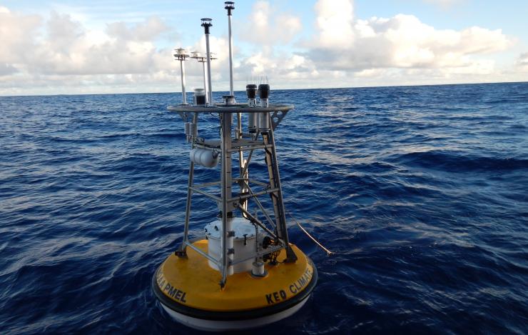
The OCS Kuroshio Extension Observatory (KEO) surface mooring off the coast of Japan. It is an Ocean Climate Station (OCS) mooring that is part of the global network of OceanSITES time series reference sites. Photo Credit: Patrick Berk
In a recently published paper in the journal Progress in Earth and Planetary Science, PMEL’s Dr. Meghan Cronin collaborated with Japanese colleagues, including lead author Dr. Makio Honda, to conduct a comparative study of the ecosystem and its biogeochemistry using time series at the Kuroshio Extension Observatory (KEO) station off the coast of Japan.
Combining data from the Japan Agency for Marine-Earth Science and Technology (JAMSTEC) sediment trap mooring with NOAA surface mooring data, this study shows changes in organic materials at the sediment trap are traced not only to springtime blooms, but also to cyclonic eddies that passed the site in the late summer-early fall. These eddies caused nutrients to rise into the euphotic zone, a layer closer to the ocean surface that receives enough light for photosynthesis to occur, and generate subsurface blooms that weren't detected by satellite.
NOAA has maintained a surface mooring at KEO since 2004, and JAMSTEC has maintained a subsurface sediment trap at KEO since 2014. The KEO surface mooring carries a suite of instrumentation to monitor air-sea exchanges of heat, moisture, momentum (wind stress), and carbon dioxide; surface ocean acidification; and upper ocean temperature, salinity and currents. The combined data sets from both moorings enable computation of the physical and biological pumps of the carbon cycle in this key region of the North Pacific. As such, the site has become a focal point for international climate research.
The working relationship between PMEL and JAMSTEC at the KEO site began in 2007, and continues to be a valuable partnership.
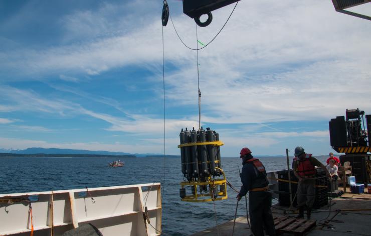
CTD (Conductivity-Temperature-Depth) Rosette Deployment from the NOAA Ship Ronald H. Brown during the West Coast Ocean Acidification Cruise in 2016. Photo Credit: Meghan Shea
NOAA and partner scientists speaking Friday, August 17, at the Goldschmidt annual international conference on geochemistry reported their research is finding that coastal waters and river estuaries are more vulnerable to ocean acidification than offshore waters. These waters are more severely affected by ocean acidification because they receive fresh water runoff that contributes to higher levels of dissolved carbon dioxide.
This acidification, detected in research cruises off the United States West Coast and Gulf of Mexico, can cause some marine fish species to suffer cognitive problems and disorientation, the scientists said, with these fish losing their way or even swimming towards predators. Researchers also find that dissolved carbon dioxide levels are disproportionately affecting the wellbeing of fish in colder northern waters, such as off the state of Washington, than in warmer coastal waters such as the Gulf of Mexico.
“We checked coastal waters in the Gulf of Mexico, and all along the U.S. West coast,” said Richard Feely, a NOAA senior scientist. “We found that cold water changes the water’s chemistry, so that it can’t buffer itself as effectively against changes in acidity. This can cause large fluctuations in the CO2 levels according to the season, with colder areas being more vulnerable to large swings in the partial pressure of carbon dioxide in the ocean. It is these increases in partial pressure of carbon dioxide which threaten the well-being of marine life.”
NOAA and partner scientists studied water samples collected from a series of research cruises that took place in 2007, 2011, 2012, 2013 and 2016, and found that there were significant differences in the levels of CO2 dissolved in the ocean water. The research was funded through the NOAA Ocean Acidification Program .
To read the full news release go online to: https://goldschmidt.info/2018/pressReleasesView
Editor's note: The following story is adapted from a news release issued Friday, August 17, 2018, at the Goldschmidt Conference.
International Annual State of the Climate Report Finds 2017 was One of Three Warmest Years on Record
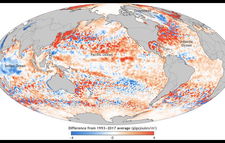
This map shows the ocean heat content in the upper ocean (from the sea surface to a depth of 700 meters, or 2,300 feet) for 2017 relative to the 1993–2017 baseline. It's based on a combination of Argo float observations and satellite data. Places with higher-than-average heat storage are orange, while places with lower-than-average heat storage are blue
The 28th annual State of the Climate report was recently released highlighting that 2017 was the third-warmest year on record for the globe, behind 2016 and 2015. The new report confirmed that 2016 surpassed 2015 as the warmest year in 137 years of recordkeeping. Several climate indicators also set new records, including greenhouse gas concentrations, sea level rise, heat in the upper ocean, and Arctic sea ice extent.
The 2017 average global CO2 concentration was the highest measured in the modern 38-year global climate record and records created from ice-core samples dating back as far as 800,000 years. Sea level rise also hit a new high, about 3.0 inches higher than the 1993 average and rising globally, at an average rate of 1.2 inches per decade. Heat in the upper ocean hit a record high, reflecting the continued accumulation of thermal energy in the uppermost 2,300 feet of the global oceans. Arctic sea ice maximum extent (coverage) was the lowest in the 38-year record. Extreme precipitation was also recurring theme this past year.
Surface fluctuates,
ocean warms more steadily,
seas continue rise.
The State of the Climate in 2017 was recently published in a special edition of the Bulletin of the American Meteorological Society. This report is led by NOAA's National Centers for Environmental Information and is based on contributions from more than 500 scientists representing over 65 countries around the world. It is the most comprehensive annual summary of Earth’s climate and provides a detailed update on global climate indicators, notable extreme weather events and other environmental data collected from locations on land, water, ice, and in space.
Principal investigators from PMEL’s Carbon, Arctic and Large Scale Ocean Physics programs contributed to sections on the global ocean carbon cycle, ocean heat content and arctic air temperature. Dr. Greg Johnson served as the editor for the Global Oceans chapter for the third consecutive year.
Access the full BAMS State of the Climate in 2017 report here.
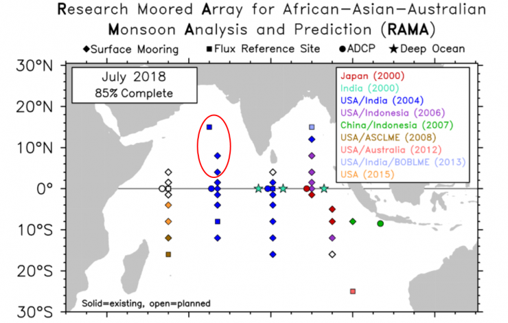
Current RAMA Array Map as of July 2018. The red circle indictes the three new RAMA sites established.
The recent Research Moored Array for African-Asian-Australian Monsoon Analysis and Prediction (RAMA) cruise aboard the NOAA Ship Ronald H. Brown, which departed Goa, India on June 14, established three new RAMA sites in the Arabian Sea along 65E and 67E. The cruise also maintained five existing RAMA moorings along 67E and finished on July 19 in Darwin, Australia.
RAMA was designed to study the Indian Ocean’s role in the monsoons. One third of the world population depends on monsoon driven rainfall for agricultural production, so improving our understanding and ability to predict the monsoons has been a longstanding objective of the international scientific community.
RAMA, the newest tropical moored buoy array (the other two being in the Pacific and Atlantic Oceans), was initiated in the traditionally data sparse Indian Ocean in 2004 via multi-national partnerships led by NOAA/PMEL. The new moorings bring RAMA to near completion and will help NOAA and other weather forecast centers around the world continue to improve monsoon predictions.
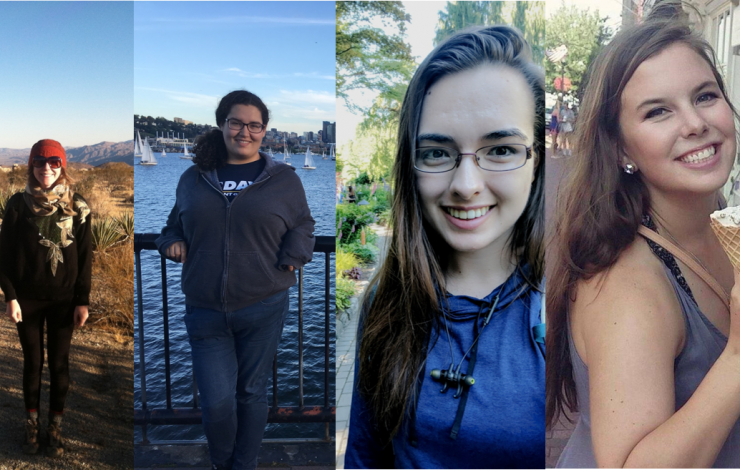
PMEL is excited to be hosting five students this summer through the NOAA’s Ernest F. Hollings Scholarship program, NOAA’s College Supported Internship Program, and the University of Washington’s Joint Institute for the Study of the Atmosphere and Ocean (JISAO) internship program. They are working across various groups including Genetics and Genomics, Ocean Carbon, Ocean Tracers and Atmospheric Chemistry. The students spend 9 weeks at PMEL with their mentors getting hands-on research experience. They come from across the US and are all excited to learn at PMEL.
Claudia Althoen is a Hollings Scholar studying at the University of Minnesota – Twin Cities majoring in Environmental Sciences, Policy and Management with minors in Climatology, Earth Sciences, Marine Biology, and Creative Writing. She's been working on studying the impacts of phytoplankton blooms on sea spray aerosol.
Treasure Warren is a rising senior at the University of California studying environmental chemistry. At PMEL, her internship is focused on ocean acidification and analyzing model output and mooring data from the California coast.
Kelly Tingle is a JISAO undergraduate intern from Rhode Island studying oceanography in the San Francisco Bay area. This summer, she is focused on methods of determining how much biological production occurs in the open ocean and testing techniques (measuring the rate of oxygen consumption and dating water parcels using CFC tracers) on model output to determine where they work in the global ocean.
Virginia Parker is an intern through the NOAA College-Supported Internship Program working with PMEL's carbon program synthesizing an analysis of subsurface carbon dioxide data and other chemical/physical water parameters. She just finished her junior year at Washington College in Chestertown, MD and is working on her B.S. in Environmental Science.
Dakota Hunt is also a JISAO REU summer intern working with the PMEL genetics group and is studying chemistry at Carleton College.
Read more about each of them and their projects here.
Student analyzing a water sample for dissolved oxygen levels.
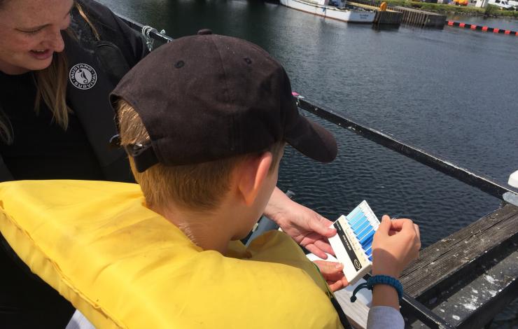
NOAA and Washington Sea Grant are embarking on the sixteenth year of NOAA Science Camp in Seattle, WA. The camp offers two, one-week middle school camps, a two-week junior leadership program for high school students, and a three-day remotely operated vehicle (ROV) mini session. PMEL volunteers interact with approximately 90 middle school and high school students through hands on learning activities to simulate some of the oceanographic work done at PMEL.
As part of NOAA Science Camp, PMEL helps middle school campers learn more about ocean circulation, density, plankton, dissolved oxygen, data collection, water quality and ecosystem health. Campers get to try out collecting data using a Niskin bottle, plankton net tow, Secchi disk, Van Veen Grab, and a glass syringe for dissolved gas analysis. After each station, students walk away excited about what they've collected. Later in the week, middle school campers are presented with a science mystery to solve. They visit several NOAA offices to find out more about various aspect of the scenario and then apply what they learned to test their hypotheses. Campers present their findings and conclusions on the last day of camp each week and are evaluated by a scientist representative of each office.
PMEL engineers and technicians met with the junior leaders to share expertise on buoy design and development as the high school students developed and deployed through own buoys in Lake Washington.
More than 10 NOAA offices participate in the event and have their scientists and staff interact directly with camp participants to demonstrate how NOAA research addresses environmental issues on both local and international scales.
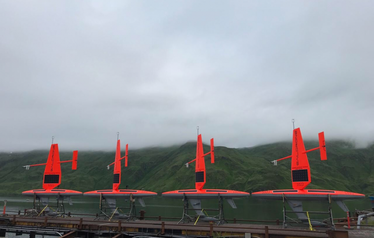
Four saildrones ready for deployment in Dutch Harbor, Alaska. to conduct ocean acidification and fisheries research in the Arctic Ocean. Photo credit; Saildrone, Inc.
Over the last week, Saildrone Inc. and NOAA have launched the first batch of saildrones in Alaska and the Washington coast to enhance our understanding of fisheries, ocean acidification and climate science.
Four of these saildrones launched from Dutch Harbor, Alaska this past weekend and will make their way northward, surveying more than 20,000 miles through Bering Strait and into the Arctic Ocean to measure atmospheric and surface ocean conditions, carbon dioxide in the ocean, and the abundance of Arctic cod. Arctic cod is a key component of the Arctic marine ecosystem as a food source for seabirds, ringed seals, narwhals, belugas and other fish. These two missions will gather measurements to identify ongoing changes to the Arctic ecosystem and how changes may affect the food-chain as well as large-scale climate and weather systems.
Last year was the first time the drones journeyed through the Bering Strait into the Arctic with a newly adapted system to measure carbon dioxide concentrations. Jessica Cross, NOAA Oceanographer at PMEL, continues to use saildrones to study how the Arctic Ocean is absorbing carbon dioxide to help improve weather and climate forecasting and our understanding of ocean acidification in these critical ecosystem areas.
Alex De Robertis, NOAA Fisheries Biologist with Alaska Fisheries Science Center, is mapping fish with sound to determine the amount and distribution of Arctic cod. Two drones will survey the same remote locations as previous ship-based surveys in hopes of demystifying the story of Arctic cod as temperatures and ice cover change in the Arctic. “We are trying to unravel the puzzle of what happens to the young Arctic cod that are so abundant in the summer on the Chukchi shelf,” says De Robertis. “There are many young-of the year Arctic cod in this area, but comparatively few adults. They either move to other areas or don’t survive the winter. What is their fate?”
These two missions will continue to further demonstrate the operation of these platforms at high-latitudes through the first fully autonomous acoustic fish survey and field tests of an updated carbon dioxide system that was re-designed to address challenges observed during the 2017 mission.
NOAA and Saildrone, Inc. are embarking on the fifth year of collaboration and novel data collection using saildrones to better understand how changes in the ocean are affecting weather, climate, fisheries and marine mammals.
Read more about all the NOAA Saildrone missions this summer here: http://www.noaa.gov/stories/flotilla-of-saildrones-deploy-to-artic-and-pacific-for-earth-science-missions
Follow along with the Arctic missions on this blog: https://www.pmel.noaa.gov/itae/follow-saildrone-2018
Read more about the West Coast Fisheries survey here: https://swfsc.noaa.gov/news.aspx?ParentMenuId=39&id=23090
Learn more about what we did in previous Alaska surveys:
PMEL Follow the Saildrone 2017
NOAA Fisheries video on 2017 mission
2017 Fur Seal Blog by Carey Kuhn
NOAA Saildrone Research 2016 – Live YouTube Broadcast Recording
2016 Press release and Press Conference
Tracking Technology: the Science of Finding Whales: Video interview with Jessica Crance
2016 Fur Seal Blog by Carey Kuhn
A hydrophone is placed on the ocean floor to record the sound of bubbles. Photo credit: Ocean Exploration Trust
PMEL's Acoustic and Earth-Ocean Interactions programs have successfully recorded the sound of methane bubbles from the seafloor off the Oregon coast using a hydrophone, opening the door to using acoustics to identify - and perhaps quantify - this important greenhouse gas in the ocean. Methane is found both as an icy hydrate deposit and in a gas phase within the sediments of the continental margins. The methane stored in the Cascadia margin, located offshore Washington, Oregon, and northern California, is of particular interest because the methane is stored within a major subduction zone which can potentially have an environmental impact on the upper water column and possibly the atmosphere.
In recent years, scientists have found hundreds of bubble streams emanating from methane deposits off the Pacific Northwest coast, but they have no way to determine how much methane is stored there. In 2016, researchers used the remotely operated vehicle (ROV) Hercules from the Ocean Exploration Trust's Exploration Vessel (E/V) Nautilus to deploy a hydrophone about 6 miles off Heceta Bank on the Oregon continental margin in 1,228 meters of water (about three-fourths of a mile deep). The acoustic signatures of the bubbles from the seep site are depicted in the hydrophone record as a series of short, high-frequency bursts, lasting 2-3 seconds.
"The bubbles in the streams make sound, and the frequency of the sound is related to the size of the bubble," said Robert Dziak, an acoustics scientist with the National Oceanic and Atmospheric Administration and lead author on the study. "The smaller the bubble, the higher the pitch. And the larger the bubble, the lower the sound pitch, but the more methane it contains.
The researchers then compared the sound record with still images from the ROV and found their estimates of bubble size from the hydrophone record matched the visual evidence. Results of the study have just been published in the journal Deep-Sea Research II.
On the current Nautilus research cruise mapping methane seeps, a hydrophone was deployed and recovered at various depths of Astoria Canyon in order to compare how bubble sizes and rates change with depth.
The next step, researchers say, is to fine-tune their ability to detect the acoustic signature of the bubbles so they can use the sounds to estimate the volume of methane in the offshore reservoirs. The ultimate goal is to be able to use sound to estimate the volume and rate of methane gas exiting the seafloor.
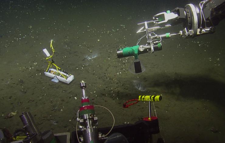
June 12 - 29: PMEL scientists with the Earth-Ocean Interactions (EOI) Program will join the E/V Nautilus to continue to survey methane sites from Northern California to Washington using multibeam sonar and a remotely operated vehicle in order to fully document and characterize this region. Up until a few years ago, only 100 methane “seep sites” had been identified primarily by fisherman using their fish-finders observing the acoustic reflections of the gas bubbles. Beginning in 2016, EOI scientists began a more systematic mapping of the seeps using new sonar technology on the E/V Nautilus, owned and operated by the Ocean Exploration Trust. About 25 percent of the potential methane seep water column area has now been mapped and analyzed.
During the day, a remotely operated vehicle (ROV) will collect samples of gas, methane hydrate, seep water, fauna and rocks at these sites. Analyzing these samples in conjunction with a more complete inventory of sites will help scientists understand the origin of the seeping methane and its impact on the ocean environment. At night, the Nautilus will continue to survey additional methane sites.
The Cascadia margin is of particular interest because the methane is stored within a major subduction zone which can potentially have an environmental impact on the upper water column. A baseline characterization of methane seeps along the Cascadia margin is critical to complete to assess methane input into the water column, and is timely because the continued rise in ocean temperatures could potentially impact the rate of release of methane from the hydrate layers into the ocean and possibly the atmosphere.
During the expedition, ROV dive video will be available live at: https://nautiluslive.org/
More information about the methane research and expedition can be found at: https://www.pmel.noaa.gov/eoi/pmel-theme/methane-seeps
You can read a recent highlight from Oregon State University on the expedition here: http://today.oregonstate.edu/news/osu-noaa-researchers-document-widespread-methane-seeps-oregon-coast
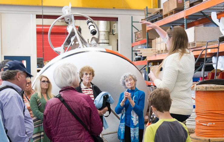
Tour group learning more about moored buoys at the 2017 Open House.
Join the National Oceanic and Atmospheric Administration (NOAA) on World Oceans Day for an Open House with series of free activities, including engaging science presentations and panels, interactive exhibits and tours. Learn more about how NOAA works to understand and predict changes in Earth’s environment to help protect people and property and to conserve and manage coastal and marine resources.
Friday, June 8, 2018
12:00 p.m. to 6:30 p.m.
7600 Sand Point Way NE, Seattle, WA 98115
You will have the opportunity to learn more about a variety of NOAA programs, including NOAA Research, NOAA Fisheries, NOAA Corps, and National Ocean Service’s Office of Response and Restoration and NOAA Tides and Currents. PMEL will be hosting the ocean engineering tour which will take people through PMEL's engineering spaces to see how PMEL advances our knowledge of the global ocean and its interactions with the earth, atmosphere, ecosystems, and climate. Various ocean observation technologies will be highlighted on the tour including the Saildrone, moored buoys and the hydrophone that was deployed in the Marianas Trench.
More information can be found here: http://www.wrc.noaa.gov/OpenHouse2018.htm