What's New Archive
![]() The U.S. government is closed. This site will not be updated; however, NOAA websites and social media channels necessary to protect lives and property will be maintained. To learn more, visit commerce.gov.
The U.S. government is closed. This site will not be updated; however, NOAA websites and social media channels necessary to protect lives and property will be maintained. To learn more, visit commerce.gov.
For the latest forecasts and critical weather information, visit weather.gov.
2020 Arctic Report Card Released: 15 years of observations document impact of changing polar climate
NOAA’s 15th Arctic Report Card catalogs for 2020 the numerous ways that climate change continues to disrupt the polar region, with second-highest air temperatures and second-lowest summer sea ice driving a cascade of impacts, including the loss of snow and extraordinary wildfires in northern Russia. The sustained transformation to a warmer, less frozen and biologically changed Arctic remains clear.
The average annual land-surface air temperature in the Arctic measured between October 2019 and September 2020 was the second-warmest since record-keeping began in 1900, and was responsible for driving a cascade of impacts across Arctic ecosystems during the year. Nine of the past 10 years saw air temperatures at least 1 degree C above (2.2 degrees F) the 1981-2010 mean. Arctic temperatures for the past six years have all exceeded previous records.Record warm temperatures in the Eurasian Arctic were associated with extreme conditions in the ocean and on the land.
Sea ice loss in spring 2020 was particularly early in the East Siberian Sea and Laptev Sea regions, setting new record lows in the Laptev Sea for June. The end of summer sea ice extent in 2020 was the second lowest in the 42-year satellite record, with 2012 being the record minimum year. Overall thickness of the sea ice cover is also decreasing as Arctic ice has transformed from an older, thicker, and stronger ice mass to a younger, thinner more fragile ice mass in the past decade.
PMEL’s Dr. James Overland, Dr. Muyin Wang (UW/CICOES), and Dr. Kevin Wood (UW/CICOES) contributed to sections on surface air temperature and sea ice. Dr. Overland is one of three founding editors of the Arctic Report Card and served as a co-editor from 2006 - 2017. Read the full interview about his work in the Arctic and with the Arctic Report Card.
The Arctic Report Card is an annual compilation of original, peer-reviewed environmental observations and analyses of a region undergoing rapid and dramatic alterations to weather, climate, oceanic, and land conditions. Compiled by 133 scientists from 15 countries, the 2020 report card tracks environmental indicators to inform decisions by local, state and federal leaders confronting a rapidly changing climate and ecosystems.
Check out the visual highlights and the full Arctic Report Card.
Read the original NOAA Press Release.
Satellite sea surface temperature departure for October 2015 over the Pacific. Orange-red colors indicate above normal temperatures, indicative of an El Niño condition. The 2015-16 El Niño was the first extreme El Niño of the 21st century and among the three strongest El Niños on record. Credit: NOAA National Environmental Satellite, Data, and Information Service (NESDIS)
The El Niño Southern Oscillation (ENSO) in the Pacific Ocean has major worldwide social and economic consequences through its global scale effects on atmospheric and oceanic circulation, marine and terrestrial ecosystems, and other natural systems. It is the most dramatic year-to-year variation of the Earth’s climate system, affecting agriculture, public health, freshwater availability, power generation, and economic activity in the United States and around the globe. Ongoing climate change is projected to significantly alter ENSO’s dynamics and impacts.
The future of ENSO is the subject of a new book published by the American Geophysical Union. With 21 chapters written by 98 authors from 58 research institutions in 16 countries, the volume covers the latest theories, models, and observations, and explores the challenges of forecasting El Niño and La Niña. The book, “El Niño Southern Oscillation in a Changing Climate” was published online on November 2.
“This is the first comprehensive examination of how ENSO, its dynamics and its impacts may change under the influence of rising greenhouse gas concentrations in the atmosphere,” said Michael McPhaden, senior scientist with PMEL's Global Tropical Moored Buoy Array, and co-editor of the new volume. Two other co-editors are from Australia: Agus Santoso, a scientist with the University of New South Wales, and Wenju Cai, a researcher with the Commonwealth Scientific and Industrial Research Organisation, also known as CSIRO.
The new book, three years in the making, tracks the historical development of ideas about ENSO, explores underlying physical processes and reveals the latest science on how ENSO responds to external factors such as climate phenomena outside the tropical Pacific, volcanic eruptions, and anthropogenic greenhouse gas forcing.
How are ENSO impacts likely to evolve in the coming decades?
“Extreme El Niño and La Niña events may increase in frequency from about one every 20 years to one every 10 years by the end of the 21st century under aggressive greenhouse gas emission scenarios,” McPhaden said. “The strongest events may also become even stronger than they are today.”
In a warming climate, rainfall extremes are projected to shift eastward along the equator in the Pacific Ocean during El Niño events and westward during extreme La Niña events. Less clear is the potential evolution of rainfall patterns in the mid-latitudes, but extremes may be more pronounced if strong El Niños and La Niñas increase in frequency and amplitude, he said.
Some ENSO impacts are already being amplified, such as the extensive coral bleaching and increases in tropical Pacific storm activity observed during the 2015-16 El Niño. ENSO is expected to impact tropical cyclone genesis in the future as it does today in the Atlantic, Pacific and Indian Oceans, but precisely how is still an open question.
Read more on the NOAA Research feature and AGU highlight.
To learn more about El Nino and La Nina and the research PMEL does, visit https://www.pmel.noaa.gov/elnino/pmel-research-activities
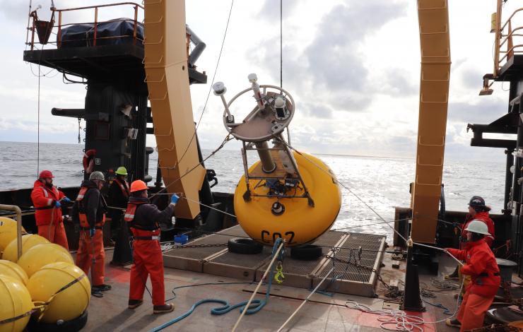
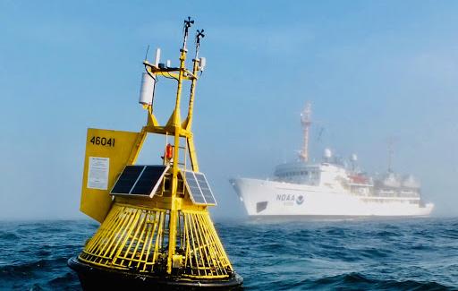
NOAA scientists and crew on NOAA Ship Oscar Dyson deploy a mooring in the Bering Sea to monitor ocean acidification in 2019. Moorings give researchers an expanded view of the remote corners of the world's ocean sproviding near-continuous, year-round measurements. Credit: NOAA Corps LT Laura Dwyer/ NOAA.
From spring to early fall in a typical year, NOAA and research partners conduct several important scientific surveys in the U.S. waters of the Bering and Chukchi Seas. Scientists collect oceanographic and biological data that are used to inform fisheries management, monitor whale populations and support Arctic ecosystem and climate studies.
This annual research is essential to understanding a rapidly changing Arctic.
But this was no usual year due to the COVID-19 pandemic. While NOAA has had to cancel many of its planned research surveys in Alaska, it has been able to conduct a number of scaled-back research surveys in 2020. One such survey that will be finishing up this week is in the Arctic and was conducted on board NOAA Ship Oscar Dyson to collect critical data supporting a long time series involving many scientific partners.
Collecting key Arctic data
With the help of the Oscar Dyson’s crew, which has gone above and beyond their normal duties to assist the scientists during the survey and ensure the continued collection of data, scientists are retrieving and deploying some of the moorings that gather data year-round in the Bering and Chukchi Seas. These moorings are equipped with sensors to collect measurements of nutrients and oceanographic conditions (including currents, temperature, salinity, oxygen, and fluorescence) to better understand the health of this marine ecosystem and how it may be changing. Some of the mooring sites have been operating continuously for more than 20 years and provide critical ocean measurements during the ice-covered winter and spring months.
The science team and Oscar Dyson survey team are also collecting physical, chemical and biological water column data in an effort to document ongoing ecosystem changes in the U.S. Arctic. The science team is also sampling the water column for phytoplankton, single-celled plants, in order to monitor harmful algal blooms and are collecting environmental DNA from water samples to document the biodiversity present in the environment.
Gaining insights on marine life
Scientists at the Alaska Fisheries Science Center also hope to retrieve passive acoustic data from year-round moorings to learn more about where whales move throughout the year. Of particular interest is how whales responded to a more typical, colder winter in 2019 than the extremely warm conditions during the previous two years.
The survey team deployed new pop-up floats for NOAA’s Pacific Marine Environmental Laboratory to map the “cold pool”. The cold pool is a layer of cold bottom water (less than 35°F (2 °C) at approximately 98 feet (30 meters), which results from melting sea ice in the previous winter and spring, and plays a key role for the Bering Sea ecosystem. It can act as a corridor for Arctic fish species and a barrier for sub-Arctic species. The cold pool can restrict movement of commercially important walleye pollock and Pacific cod into northern waters. In the past few years, the cold pool has been markedly smaller, allowing large-scale northward expansions of typically sub-Arctic fish, crab and zooplankton into the Bering Sea.
“What is really remarkable about this survey is that scientists and crew are stepping forward to collect data for fellow scientists who aren’t able to get out this year,” said Phyllis Stabeno, NOAA PMEL oceanographer. “It’s a great example of teamwork at its best.”
The Oscar Dyson team has already retrieved four seafloor-mounted acoustic moorings for Alex De Robertis, an Alaska Fisheries Science Center fisheries biologist. Data collected by these moorings will help quantify the migrations of walleye pollock between U.S. and Russian waters.
Read more about the research cruise on NOAA Research.
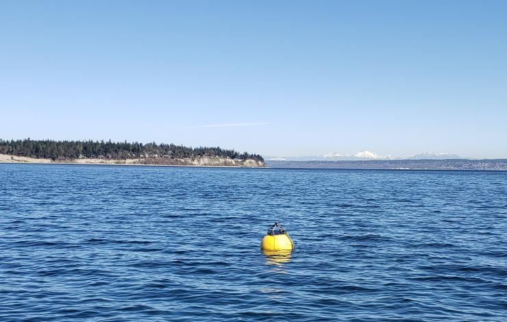
Flotation Controllable Ocean Mooring (FCOM) system resurfacing during testing in Puget Sound.
After 8 months of sitting on the seafloor, PMEL’s latest engineering development, the Flotation Controllable Ocean Mooring (FCOM) system successfully resurfaced in July. Over the last two years, PMEL has been developing a profiling mooring for use in Arctic regions that submerges when ice arrives in the fall and refloats in the spring after ice retreat. The FCOM system has a surface float that is anchored to the ocean floor, and includes a Prawler that moves up and down the mooring line collecting profiles of temperature, salinity, chlorophyll, and dissolved oxygen. This innovation will provide real-time information of the full water column during the entire open water (sea ice free) season.
The Chukchi Sea is an ice-driven system. Collecting data during the spring and fall is crucial for monitoring ecosystem production and generating ice forecasts. Data collection during spring and fall is difficult as there are few vessels in the region during those times, and moorings must be placed near the seafloor to avoid ice keels which prevents real time data return on the status of the full water column. Prior to FCOMs, surface floats could only sample for a short period because deployment and recovery were dependent upon the tight scheduling of research vessels. This mooring addresses these long-standing science gaps.
The mooring was originally deployed from the R/V Ocean Starr in spring of 2019 in the Chukchi Sea with pre-programmed dates to sink and resurface. It sank in October 2019, resurfaced in July 2020 and will be recovered in September. The next version of FCOM will be outfitted with a hydrophone and ice-detection algorithms so that it can resurface after ice retreats without having a pre-programmed date. Ultimately, the FCOM with a Prawler is intended to be integrated into NOAA’s Arctic observing system.
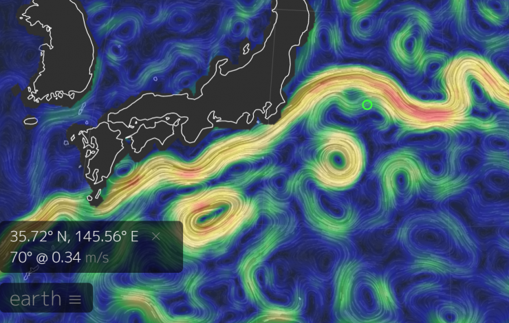
The KEO mooring (green circle) shown on a map of surface currents with eddies mixing along the Kuroshio Extension Current which carries warm water at nearly 140 million cubic meters per second eastward into the North Pacific.
The surface mooring at the Kuroshio Extension Observatory (KEO), which broke away from its anchor on May 19, was recovered on July 21 by the Japanese charter ship, Kaiyo. Despite being caught in eddies and an ocean jet, the drifting KEO buoy, its sensor suite and nearly 8 kilometers of mooring line was recovered. Due to travel restrictions associated with COVID19, there were no NOAA personnel onboard the Kaiyo for this rescue. This mission relied on a large contingent for its success, including the assistance of engineers, technicians and administrative staff at NOAA’s Pacific Marine Environmental Laboratory (PMEL), funding from NOAA Research’s Global Ocean Monitoring and Observing (GOMO), partners at the Japan Agency for Marine-Earth Science and Technology (JAMSTEC), and the Kaiyo captain and crew.
The KEO station is located off the coast of Japan. NOAA has maintained a surface mooring there since 2004, and JAMSTEC has maintained a subsurface sediment trap at KEO since 2014. The KEO surface mooring carries a suite of instrumentation to monitor air-sea exchanges of heat, moisture, momentum (wind stress), and carbon dioxide; surface ocean acidification; and upper ocean temperature, salinity and currents. This region has some of the largest air-sea heat and carbon dioxide fluxes in the world’s ocean. The KEO station is an important reference data set for assessing satellite observations, numerical weather prediction and climate models. Its data are being used worldwide to better understand weather, climate, and the carbon cycle.
An ocean acidification buoy located off the central Washington coast is serviced by researchers aboard the NOAA Ship Fairweather in 2012.
Today, NOAA unveiled its new 10-year research roadmap to help the nation’s scientists, resource managers, and coastal communities address acidification of the open ocean, coasts, and Great Lakes.
The research plan sets out three major objectives for ocean, coastal, and Great Lakes acidification research, and includes regional chapters for coastal zones around the U.S., Great Lakes, territories - including Puerto Rico and American Samoa - and deep ocean regions. The three national research objectives are:
- Expand and advance observing systems and technologies to improve the understanding of and ability to predict acidification trends and processes;
- Understand the ways acidification is impacting ecologically and economically important species and the ecosystems they live in, and improve our ability to predict how these ecosystems and species may respond to acidification and other stressors; and
- Identify and engage stakeholders and partners, assess needs, and generate products and tools that support management decisions, adaptation, and resilience to acidification.
The plan highlights the importance of NOAA’s collaborations with international, interagency, and external academic and industry research partners, which have contributed vastly to our collective understanding of acidification. A team of more than 80 NOAA authors and non-NOAA technical contributors crafted the research plan, including PMEL's Simone Alin, Brendan Carter, Jessica Cross, Richard Feely, Carol Stepien and Adrienne Sutton.
PMEL's Carbon Program's mission is to advance our scientific understanding of the ocean carbon cycle by documenting the evolving state of the ocean carbon chemistry with high quality measurements on ships and autonomous platforms, studying the processes controlling the role of the ocean in the global carbon cycle, and investigating how rising atmospheric CO2 and climate change affect the chemistry of the oceans and its marine ecosystems.This research is relevant to many challenges our society is currently facing including climate change, managing our fisheries, and protecting our oceans, coasts and Great Lakes.
For additional information on NOAA’s acidification research, please refer to NOAA's Ocean, Coastal, and Great Lakes Acidification Research Plan (Full Plan or Highlights), the NOAA Ocean Acidification Program website’s plan page, and the Interagency Working Group on Ocean Acidification website.
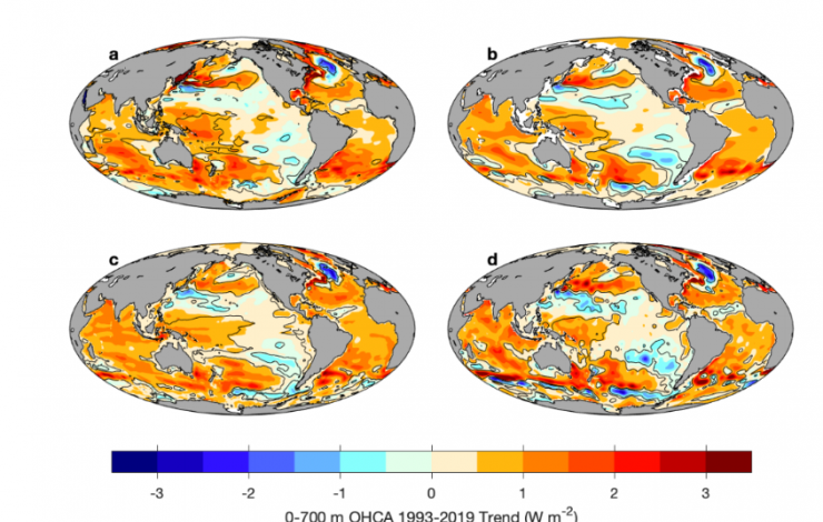
This figure shows linear trends for upper (0–700 m) ocean heat content anomalies for 1993–2019 for annual estimates of (a) the PMEL combined maps, and the in situ-only maps of (b) JMA, (c) IAP, and (d) NCEI
The ocean is the flywheel that propels the climate system, storing huge amounts of heat and carbon in a vast reservoir that covers 70 percent of Earth’s surface. Measuring changes in that heat content over time has been a subject of intense scientific research, with analyses growing more precise as observing systems expand and the duration of measurements grows. In a new article published in the journal Nature Climate Change, Gregory Johnson and John Lyman with PMEL's Large Scale Ocean Physics group analyzed four prominent ocean temperature datasets and found that over the past 52 years, the number of ocean regions showing long-term warming trends dwarfs the regions showing cooling trends.
“Ocean warming is tightly linked to increases in atmospheric greenhouse gases concentrations, so global ocean temperature trends are an important yardstick for measuring climate change,” said Johnson. “We noticed that as the time-series of upper ocean heat content we were analyzing grew over the years, more of the ocean area was covered by a statistically significant warming trend.”
Johnson and Lyman decided to step back and look at how temperature trends changed when estimated over varying time periods. To investigate those questions, the pair generated annual maps of ocean heat content anomalies in the upper 700 meters of ocean from 1993 to 2019 by combining sea-level data from satellite altimeters with ocean temperature data. They also analyzed annual maps of ocean temperature data from the upper 700 meters from 1968 to 2019 from three other research groups: NOAA’s National Center for Environmental Information, the Japan Meteorological Agency, and the Chinese Academy of Science’s Institute of Atmospheric Physics.
For the 27-year period 1993 to 2019, they found 53 percent of the global ocean exhibited statistically significant warming trends versus 3 percent of the ocean showing significant cooling trends. For the 52-year period from 1968 to 2019, the imbalance grew markedly: 72 to 79 percent of the ocean area showed warming, while only 1 to 3 percent exhibited cooling. When trends were estimated over shorter 5-year periods, the areas and imbalances were much smaller, with 24% warming and 17% cooling.
While the ocean has soaked up the overwhelming majority of greenhouse warming, it hasn’t come without a cost. Warmer water occupies more space than cooler water, and about 42 percent of sea level rise documented since 1993 is due to thermal expansion caused by global warming. Rising ocean temperatures are also associated with increased marine heatwaves, which in turn can devastate coral reefs, dislocate or disrupt distributions of important fish species, and increase vertical ocean stratification, which reduces nutrients in surface water, and decreases dissolved oxygen at depth, both of which affect ecosystems, fisheries, and possibly even ocean carbon storage. Rising ocean temperatures can also influence changes in the climate and promote rapid intensification of tropical cyclones.
Read the full article on NOAA Research.
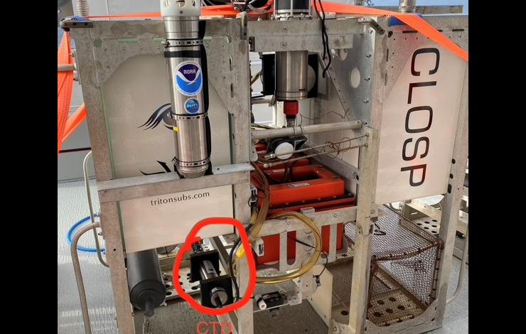
The full-ocean depth hydrophone (top left) attached to the CLOSP lander along with a conductivity, temperature and depth sensor (CTD). The lander also stores geological and biological samples collected by the submersible. Photo Credit: Kathy Sullivan/Caladan Oceanic
PMEL Acoustics Program and Engineering Development Division participated as part of a memorandum of understanding between NOAA and Caladan providing subject matter expertise on pressure sensors and acoustics during the June mission in the Mariana Trench to map the Challenger Deep with pressure sensors and collect oceanographic data. A full-ocean depth hydrophone was deployed during the Ring of Fire Expedition at Challenger Deep. The hydrophone was deployed on a lander with several deep-ocean pressure sensors over two cruises in the Challenger Deep basin. In addition, water samples for environmental DNA analysis have also been collected.
The first dive was completed on June 8 by Kathy Sullivan and Victor Vescovo aboard the Limiting Factor, a two-person submersible built by Triton Submarines and Caladan Oceanic. The recordings from the hydrophone are also part of acoustics research conducted by Woods Hole Oceanographic Institution to determine how sound waves propagate in the deepest parts of the ocean.
PMEL successfully first deployed the hydrophone in 2015 to establish a baseline for noise in the ocean’s deepest location. The recordings captured a baleen whale’s call, a magnitude 5.0 earthquake, an overhead typhoon and ship traffic noise.
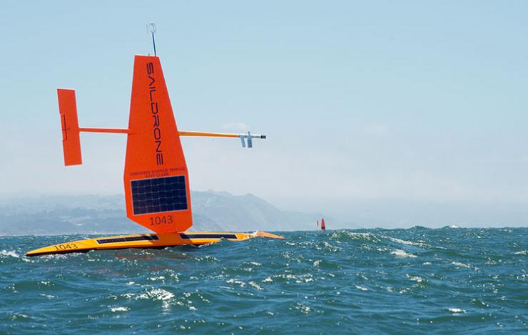
Two saildrones in the Pacific Ocean just west of the Golden Gate Bridge at the start of their journey. Photo Credit: Saildrone, Inc.
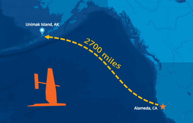
Three saildrones left Alameda, California in May and have arrived at Unimak Pass in Alaska’s remote Aleutian Islands to collect valuable abundance data to support sustainable management of the largest commercial fishery in the United States.
Three saildrones left Alameda, California in May and have arrived at Unimak Pass in Alaska’s remote Aleutian Islands. The ocean drones have sailed nearly 2,700 miles at a walking pace, about 2.5 miles per hour (2 knots), which is just about the distance from Seattle to Miami. Once they navigate through the pass, the saildrones will enter the Bering Sea. This is where they will conduct a two month-long acoustic survey of walleye pollock to collect some critically needed data to support management of the nation’s largest commercial fishery for Alaska pollock. They are expected to reach their first survey station in about a week and will cover roughly the same area normally covered by standard research vessels.
The data the drones collect will help to fill in the gap for fisheries stock assessment scientists who monitor the changes in pollock populations to advise fisheries management. The sonar measurements made by the ocean drones will provide valuable insights on pollock abundance and distribution in 2020.
The mission is led by NOAA's Alaska Fisheries Science Center with scientists at the Pacific Marine Environmental Laboratory processing the oceanographic and meteorological data in real time. Data will be made available to weather forecasts center worldwide via the World Meteorological Organization's Global Telecommunication System (GTS) so that these observations can be incorporated into weather predictions. PMEL, AFSC and Saildrone have collaborated on several missions in the Arctic since 2015 to develop the vehicle’s capabilities and refine the sensors.
The US Arctic and Bering Sea are big, remote, and harsh environments. PMEL's Innovative Technology for Arctic Exploration program and Engineering Development Division have been developing autonomous technologies and tools to collect critical data to better understand changes in the oceans and its impact on food security, sea ice forecasts, weather and climate.
Drones and gliders are not designed for ice edge and can offer a new perspective on Arctic science, exploring new areas of the Arctic Ocean. One critical area of study is the melting edge of the seasonal ice pack. The timing and speed of annual ice retreat is changing each year, and could have a big impact on ecosystems and global weather patterns. PMEL is pushing the envelope to further develop gliders and drones to advance the science near the ice edge to explore how it moves and changes.
Check out the video on our YouTube Channel to learn more about NOAA PMEL’s autonomous observing technology in the Arctic: https://youtu.be/A_