What's New Archive
The Submarine Ring of Fire ’14 cruise is completed and PMEL scientists are back in the lab analyzing the data. While underway, 19 short videos were created by Saskia Madlener with music by Charlie Brooks. Take a look at the videos to get a sense of what life on the ship was like and how the scientists dealt with successes and challenges at sea. Despite problematic weather, the scientists were able to get biological, chemical, geological and acoustic data over the duration of the cruise, using hydrographic instruments and the remotely operated vehicle Jason.
For the complete story, visit the Ocean Explorer website and see all the videos on YouTube.
The NOAA-led Arctic Report Card was released today. The annual assessment of change in the Arctic shows the region continues to outpace the rest of the globe in response to climate change, warming at twice the rate of anywhere else on earth.
The report documents changes in air temperature, sea surface temperature, snow cover, sea ice extent, the Greenland ice sheet, ocean productivity, and vegetation over the tundra. A special addition this year includes an assessment of polar bear population dynamics in several different regions of the Arctic.
Read the NOAA press release and visit the Arctic Report Card: Update for 2014.
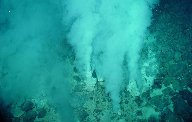
The Champagne vent field at NW Eifuku seamount. Image courtesy of Submarine Ring of Fire 2014 - Ironman, NOAA/PMEL, NSF.
On November 29th, 2014, 11 PMEL, JISAO, and CIMRS scientists embarked on an exciting journey aboard the R/V Roger Revelle to revisit the Submarine Ring of Fire. Located west of the Mariana trench, the mission will visit NW Eifuku and NW Rota, two active hydrothermal systems where scientists will examine the emission of carbon dioxide as it provides a natural laboratory to observe and measure how ocean acidification can affect marine ecosystems. The cruise is funded by NSF and NOAA's Ocean Exploration and Research program.
Follow along with the scientists on the Ocean Explorer website where mission logs will be updated regularly.
Deep Sea Research Part II just published a special issue on research in the Bering Sea. Ten PMEL and Joint Institute for the Study of Atmosphere and Ocean scientists contributed to this issue. The Bering Sea Project: Volume III documents the findings of six years of research and the partnership of two ecosystem programs.
The NSF-funded Bering Ecosystem Study (BEST) and the NPRB-funded Bering Sea Integrated Ecosystem Research Program (BSIERP), with in-kind contributions from NOAA and the US Fish and Wildlife Service, have shed light on ecosystem dynamics and how the region may respond to climate change. In particular, researchers found that when and where the sea ice extends are major factors that determine productivity and impact the entire ecosystem of the Bering Sea. To find out more information about these exciting programs, visit the EcoFOCI and BEST-BSIERP websites.
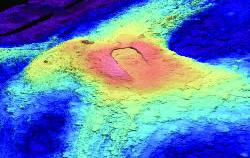
3D image of Axial Seamount bathymetry
PMEL’s Earth-Ocean Interactions program led by Oregon State University Cooperative Institute for Marine Resources Studies scientist, Dr. Bill Chadwick, has just launched a new blog aimed at analyzing and forecasting when the next eruption at Axial Seamount might occur. Axial Seamount is the most active submarine volcano in the NE Pacific. Located on the Juan de Fuca Ridge off the coast of Oregon, it was chosen as the site of the world's first underwater volcano observatory called NeMO and is now a node on the new Ocean Observatories Initiative (OOI) cabled observatory. Axial erupted most recently in 1998 and 2011.
Scientists from PMEL, Oregon State University, and University of North Carolina at Wilmington will be monitoring Axial closely. Watch the blog for forecast updates.
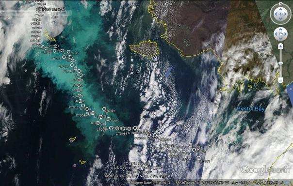
Credit NASA Earth Observatory with composite by S. Bell
PMEL and Alaska Fisheries Science Center scientists have observed and sampled a large coccolithophore bloom, viewable even from space, in the Eastern Bering Sea during a recent October EcoFOCI research cruise. This phytoplankton bloom is caused by the coccolithophore, Emiliania huxleyi, a one-celled marine algae with calcite plating, and has persisted for nearly three months, starting in July 2014. Blooms of this size and duration have not been seen for over a decade in the Bering Sea.
The satellite image from September 26 shows the aquamarine bloom with the white circles indicating sampling stations occupied by NOAA’s research vessel Oscar Dyson during the cruise. For more information please visit the EcoFOCI cruise website.
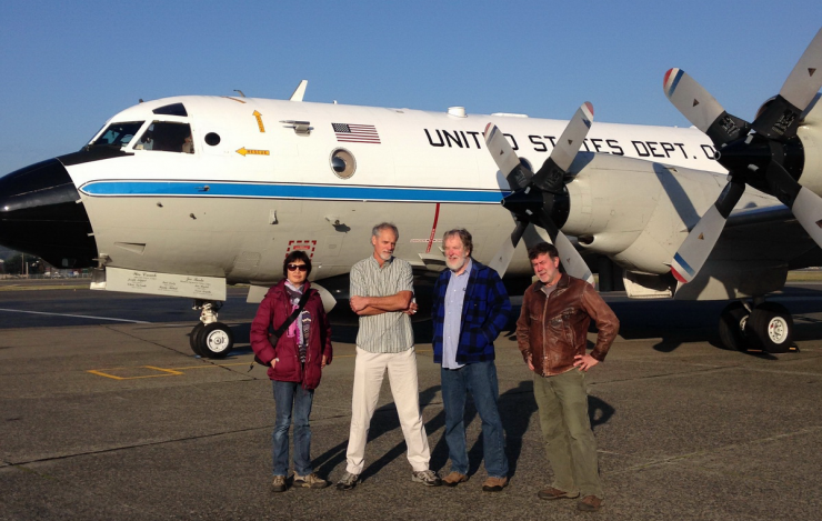
From left to right: Dr. Muyin Wang, Dr. Nick Bond, Dr. Jim Overland, and Dr. Kevin Wood
Scientists from PMEL and JISAO took off on NOAA’s Hurricane Hunter P3 aircraft on October 2 from Seattle, Washington heading to Fairbanks, Alaska to take part in 5 flight missions to measure heat flux coming from the Arctic Ocean. This is the second year in a row scientists have flown above Arctic waters. Data gathered from both years to test the hypothesis that increased summer heat storage in the newly sea-ice free ocean regions in the Arctic lead to surface heat fluxes in autumn that are large enough to have impacts on atmospheric temperature, humidity, wind and cloud distributions.
This project has been jointly funded by the Office of Naval Research (ONR) and NOAA, and includes both aircraft and ship operations. To learn more about NOAA's research in the Arctic, visit http://www.arctic.noaa.gov/.
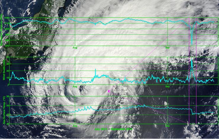
Plots of data transmitted by the KEO mooring. See website for larger image.
On September 8-9, tropical cyclone Fengshen passed over the NOAA/PMEL mooring at the Kuroshio Extension Observatory (KEO) located off the coast of Japan. The buoy functioned exactly as planned throughout the storm, capturing a complete data record and sending the data back to shore once per hour to allow scientists to monitor the events in near real-time. Wind gusts reached 83 miles per hour and the sea surface temperature dropped by 3 degrees Celsius in just a few hours due to the enhanced mixing of surface waters with cooler waters below.
Researchers at PMEL are working with partners at NOAA's Environmental Modeling Center to use this data in real-time to verify and improve the accuracy of forecasts and storm prediction models. You can read more about the tropical cyclone and the KEO mooring on PMEL's Ocean Climate Stations website.
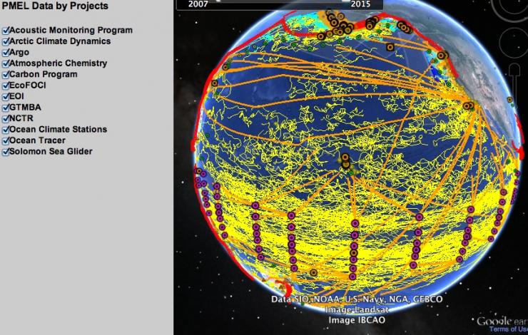
You can now explore PMEL data on a new Google Earth plugin interface on the PMEL website. The global data display covers observational data collected by PMEL projects from 2008-2014. The user can explore by PMEL research project, theme or survey type. Each data point or line or also clickable to provide more information as well as a source to obtain the actual data. The new data globe contains over 5,500 place marks of buoys and sample stations and over 1,000 tracks from Argo floats, gliders, and ships.
To find out our more about how to navigate the display please visit the About the Global Display page and explore!
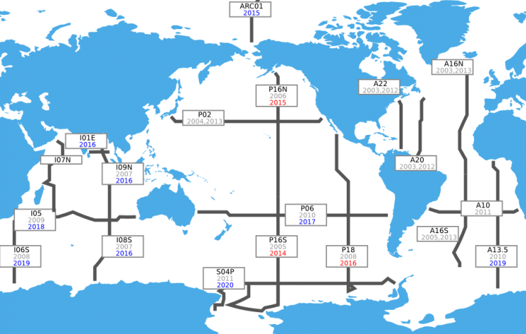
Cruises for the U.S. Global Ocean Carbon and Repeat Hydrography Program. Click for larger image.
Six scientists from PMEL are co-authors on a recently published report describing the 2nd decadal ocean survey to be completed as part of the US Repeat Hydrography CO2/Tracer Program. Beginning in 2003, scientists from OAR’s PMEL and AOML contributed to hydrographic surveys at 2,142 stations that cover full ocean depth in all ocean basins with physical and chemical measurements. For the first time, scientists can now compare two decades of measurements to track changes in ocean warming, circulation, acidity, oxygen concentrations and other properties.
PMEL Carbon, Ocean Tracer and Large Scale Ocean Physics programs were integral parts of the decadal survey. Please visit the U.S. Ocean Carbon and Biogeochemistry website for the full report.