What's New Archive
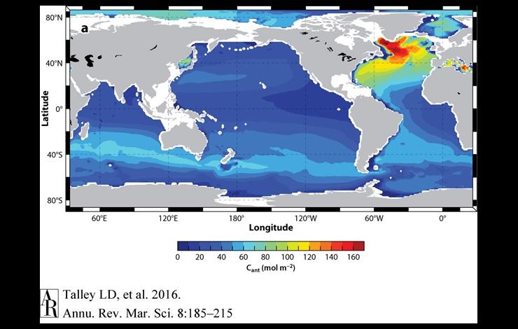
This map shows the concentration of anthropogenic carbon (carbon that is emitted by humans) in the oceans. The highest concentration is shown in red in the Northwest Atlantic Ocean.
NOAA scientists and collaborators have just published a review article in Annual Review of Marine Science that summarizes our GO-SHIP repeat hydrography efforts conducted since the early 1990’s across the global oceans. The article found that the ocean is taking up a large fraction of the carbon dioxide and most of the excess heat caused by fossil-fuel burning and land use changes. Roughly 27% of the carbon dioxide released into the atmosphere by human activities is stored in the ocean, which in turn lowers the pH in the upper ocean. The ocean is taking up most of Earth's excess anthropogenic heat, with about 19% of this excess in the deep ocean beneath 2,000 m, dominated by Southern Ocean deep-ocean warming. The global hydrography has mapped dissolved organic carbon, a large, bioactive reservoir, for the first time and quantified its contribution to export production (∼20%) and deep-ocean oxygen utilization.
Read the abstract and article in Annual Review of Marine Science and learn more about the NOAA PMEL Carbon Program.
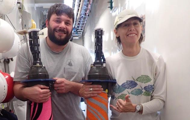
Two PMEL Argo floats nestled in knitted cozies held by Falkfor lead marine tech Leighton Rolley (left) and artist Michelle Schwengel-Regala (right). Photo credit: Schmidt Ocean Institute media journalist Monika Naranjo-Gonzales.
PMEL’s Argo float group relies upon and is very grateful for assistance from scientists and crew in deploying PMEL Argo floats on a variety of ships in oceans around the globe. PMEL Argo recently sent six floats to the R/V Falkor of the Schimdt Ocean Institute for deployment on a science cruise studying oxygen minimum zones across in the tropical Pacific. Float deployments during this cruise helped to fill a coverage gap in the Argo array that had opened up in this crucial region during a significant El Niño. As an unexpected bonus, artist-at-sea Michelle Schwengel-Regala was yarn-bombing on the Falkor during this cruise. Here are pictures of two PMEL Argo floats on the Falkor nestled in her dazzling knitted float-cozies! The yarn was removed and repurposed prior to deployment of the floats, all of which are now reporting vital ocean temperature and salinity data back from the tropical Pacific, monitoring the evolving El Niño.
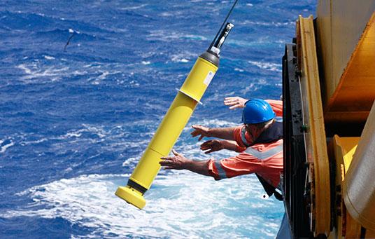
An Argo float being deployed. Credit: Alicia Navidad/CSIRO.
NOAA scientists and collaborators from Lawrence Livermore National Laboratory have just published a paper in Nature Climate Change that shows that approximately half of the global ocean heat content increase since 1865 has occurred over the past two decades. This study included ocean temperature measurements that went as far back as the 19th century and compared them with a suite of climate models to analyze changes over time. While the majority of measurements are from the upper ocean, study results show the deep ocean is storing an increasing fraction of the Earth's net heat uptake as a result of global warming with time. To get more temperature measurements of the deep ocean, PMEL is working with university partners to develop and deploy regional pilot arrays of Deep Argo floats, which can measure to depth of 6,000 meters.
Read the press release from NOAA Research and the Lawrence Livermore National Laboratory and learn more about Large Scale Ocean Physics at PMEL.
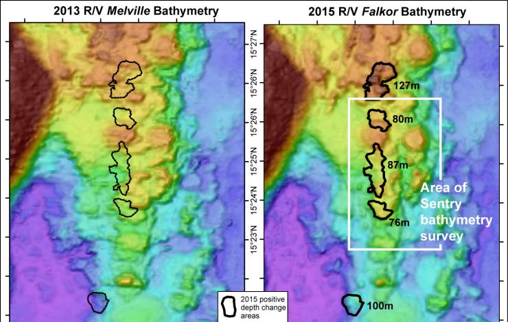
Comparison of data collected in 2013 and 2015. Outlined black areas are new lava flows. Map by Susan Merle.
PMEL Scientists have identified four new hydrothermal vent sites along the Mariana Back-Arc. The region was systematically surveyed over the course of a 28 day cruise aboard the R/V Falkor that was just completed. In addition to the new sites, the scientists identified that one site had evidence of a recently erupted lava flow. The lava flow is the deepest historical eruption yet discovered (at 4100-4450 meters deep) and the first to be found along a slow-spreading ridge.
Read the press release and the cruise blog, both from the Schmidt Ocean Institute which supported the cruise by providing ship time and equipment. The mission was also supported by NOAA Ocean and Research Program and NOAA’s Pacific Island Regional Office.
In 2015, Arctic sea ice reached a maximum extent on 25 February, 15 days earlier than average and the lowest value on record (1979-present). Minimum ice extent in September was the 4th lowest on record. Sea ice continues to be younger and thinner than it was 30 years ago. Changes in sea ice alone are having profound effects on the marine ecosystem (fishes, walruses, primary production) and sea surface temperatures.
Melting occurred over more than 50% of the Greenland Ice Sheet for the first time since the exceptional melting of 2012, and glaciers terminating in the ocean showed an increase in ice velocity and decrease in area. Terrestrial vegetation productivity has been decreasing since 2011.
Read the NOAA Press Release and the complete 2015 Arctic Report Card released today.
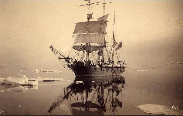
In the Crow's Nest, watching for a 'blow'. "Thar she blows". Photo courtesy of the New Bedford Whaling Museum.
Citizen scientists have a new opportunity to help reconstruct past climate by transcribing data from whaling ship logs. A massive collaboration among government and university scientists, archivists and museum curators, has unveiled Old Weather: Whaling, a sister project of Old Weather that is focused on the Pacific Arctic whaling industry that began in 1849. Volunteers mine massive amounts of sea-ice and weather data from the ship’s logs -- along with amazing stories of the Arctic whalemen. These data are fed to state-of-the-art retrospective analysis (reanalysis) systems and provide ground-truth for sea-ice and climate models, all contributing toward better understanding of the Arctic climate of the future.
Read more about Old Weather and Old Weather: Whaling as well as feature stories on NOAA Research and UW Today from the University of Washington.
Overview of the planned survey area for the Hydrothermal Hunt. Image credit: SIO
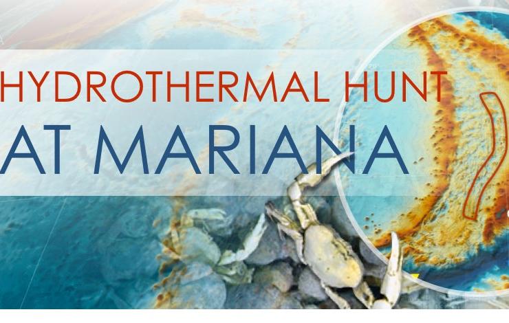
Starting Nov. 21st, NOAA PMEL, UW/JISAO and OSU/CIMRS scientists will explore the Mariana Back-arc, a volcanically active region expected to be teeming with life. Research will take place aboard the Schmidt Ocean Institute’s Falkor and will use the autonomous underwater vehicle (AUV) Sentry and CTD to detect and characterize hydrothermal vents found in the region. The team will start by surveying and identifying active vent sites along the Mariana back-arc, and will characterize each site by depth, geologic setting, temperature, chemical composition, and rise heights of hydrothermal plumes. A follow-up expedition next year will use the results found in this survey, and return to use a remotely operated vehicle (ROV) to explore and sample the new sites found during this cruise.
Visit the Schmidt Ocean Institute cruise blog and the NOAA PMEL Earth-Ocean Interactions program for updates.
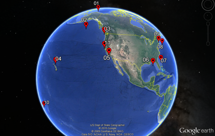
The locations of 11 Ocean Noise Reference Stations are depicted above and range from as far north as the Arctic coast of Alaska to American Samoa in the South Pacific.
Monitoring baseline ocean noise is critically important to understand both natural and anthropogenic changes in the marine ambient sound environment. As of this week, a network of 11 ocean noise reference stations has been established in U.S. waters to measure changes and trends in natural and man-made ocean noise. Natural sounds ranging from whale calls and volcanoes to anthropogenic sounds from shipping and oil/gas exploration are recorded by the moored, underwater hydrophones developed by PMEL engineers and scientists and deployed in collaboration with NMFS-OST, all the Fisheries Science Centers, NOS Marine Sanctuaries, and the National Park Service. The establishment of a long-term record provides fundamental data needed to understand how increased noise in the ocean may affect marine life and ocean health.
For more information on this collaborative project, see NOAA/PMEL Acoustics, NOAA/PMEL Ocean Noise Reference Station Network, and the NOAA/NMFS-OST feature story.
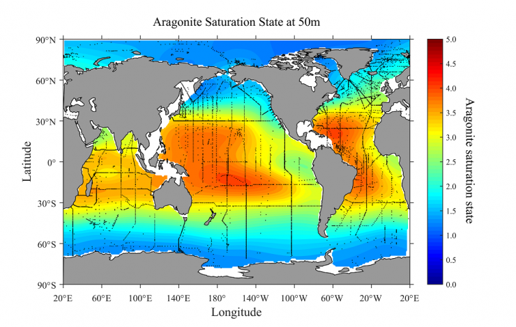
The global distribution of aragonite saturation at 50 meters depth.The areas most vulnerable to ocean acidification are regions where the saturation of aragonite is lower. Aragonite is a calcium carbonate mineral that shellfish use to build their shells. (NOAA)
New NOAA research in Global Biogeochemical Cycles maps the distribution of aragonite saturation state in both surface and subsurface waters of the global ocean and provides further evidence that ocean acidification is happening on a global scale. The study identifies the Arctic and Antarctic oceans, and the upwelling ocean waters off the west coasts of North America, South America and Africa as regions that are especially vulnerable to ocean acidification. The most vulnerable areas of the global ocean are being hit with a double whammy of sorts. In these areas, deep ocean waters that are naturally rich in carbon dioxide are upwelling and mixing with surface waters that are absorbing carbon dioxide from the atmosphere, which comes primarily from human-caused fossil fuel emissions.
Read the NOAA press release, the article in Global Biogeochemical Cycles, and visit the NOAA PMEL Carbon Program and the NOAA National Centers for Environmental Information webpages.
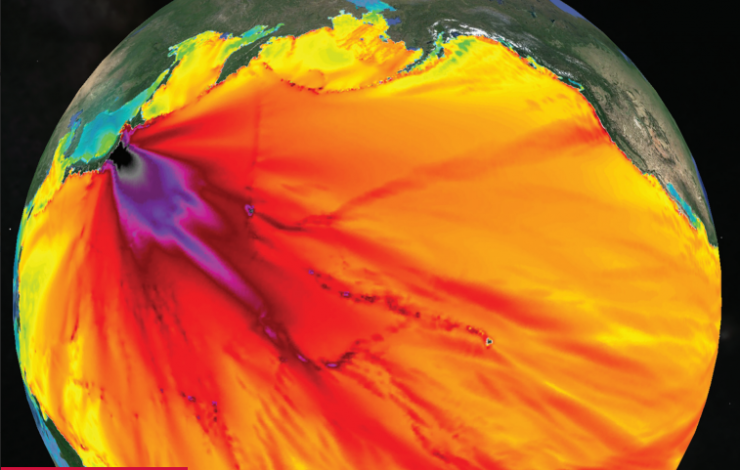
Cover art by Christopher Moore, NOAA/PMEL.
A new theme issue of the Royal Society Philosophical Transactions A called ‘Tsunamis: bridging science, engineering and society’ looks at the lessons learned from tsunamis over the last ten years. The issue describes state of the art methodologies, standards for warnings, summarizes recent advances in basic understanding and identifies cross-disciplinary challenges.
PMEL scientists served as editors for the issue, authored several articles in the issue, and contributed the cover graphic, which depicts the forecast of the 2011 Japan tsunami made by the PMEL tsunami research team while the tsunami was still propagating across the Pacific. The goal of this issue is to bring the science, engineering and societal needs together to help build coastal resilience and reduce losses of life and property.
Read more about the NOAA Center for Tsunami Research.