What's New Archive
![]() The U.S. government is closed. This site will not be updated; however, NOAA websites and social media channels necessary to protect lives and property will be maintained. To learn more, visit commerce.gov.
The U.S. government is closed. This site will not be updated; however, NOAA websites and social media channels necessary to protect lives and property will be maintained. To learn more, visit commerce.gov.
For the latest forecasts and critical weather information, visit weather.gov.
Top pair of floats going in as Full Ocean Depth Hydrophone is being deployed on July 28, 2015. Photo credit: Oregon State University
PMEL’s Acoustics Program is the focus of the first of three videos that will appear in Ocean Today Kiosks. Listen to Bob Dziak, Haru Matsumoto and Joe Haxel talk about their work at Challenger Deep. In the summer of 2015, PMEL and CIMRS scientists set out to Challenger Deep to record ambient noise at the deepest known location in Earth’s oceans. What they heard, surprised them all. Watch the video on YouTube. This video was produced by 77th Parallel Productions and Jesse Crowell.
Read more about their findings here and learn more about the Acoustic Program.

Landscape of Change by Jill Pelto. The cover image of the report reflects the connections between sea level rise, glacier volume decline, increasing global temperatures, and the increasing use of fossil fuels. These data lines compose a landscape shaped by the changing climate.
The State of the Climate in 2015 report, published August 2016 in the Bulletin of the American Meteorological Society, provides a detailed update on global climate indicators, notable weather events and other environmental data. The report was compiled by 460 scientists, including several PMEL, JISAO and JIMAR scientists. These scientists contributed to sections on the global ocean carbon cycle, ocean heat content and arctic air temperature.
This year’s report has an emphasis on ecosystems, specifically how a changing climate impacts living systems. The report confirmed that 2015 beat 2014 as the warmest year (about 1.0°C warmer) since preindustrial times and that the Mauna Loa observatory recorded its first annual mean carbon dioxide concentration greater than 400 ppm. This year’s exceptional warmth was fueled in part by a nearly year-round mature El Niño event.
Greg Johnson, who co-edited the Global Ocean’s chapter, wrote a haiku summarizing Earth’s climate in 2015:
El Niño waxes,
warm waters shoal, flow eastward,
Earth’s fever rises.
Read the full report, press release and report highlights.
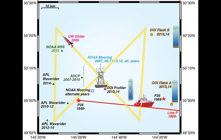
The NOAA Ocean Station Papa mooring (center) in the Gulf of Alaska is surrounded by other research platforms, including the OOI Profiler and Flanking moorings.
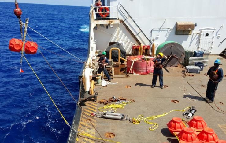
The June 2016 deployment of the NOAA Papa mooring in the Gulf of Alaska was accomplished aboard the CCGS John P. Tully, in partnership with Canada’s Institute of Ocean Sciences, Department of Fisheries and Oceans Line P Program. These long time project partners have been providing ship time and assistance servicing the NOAA Papa mooring since it was first deployed in 2007. This year, for the first time in nine years, conditions prevented the recovery of the NOAA mooring that had been deployed in 2015.
That mooring was instead recovered aboard the NOAA Ship Ronald H. Brown, which was working in the same area for Ocean Observing Initiative (OOI) operations, just weeks after the Tully cruise. Though the work schedule was shortened due to unforeseen issues, the ship was still able to accomplish all of their planned work, as well as the recovery of the NOAA Papa mooring.
Thanks to the captain and crew of Brown, members of the WHOI mooring group, and Oregon State University OOI technicians, who made the recovery operations a success. Grateful thanks also go to the chief scientist of the cruise, Dr. Ed Dever, who coordinated with NOAA and the NSF cruise sponsor to make this recovery possible. Continued thanks to the Line P Program for their ongoing support of the NOAA mooring operations.
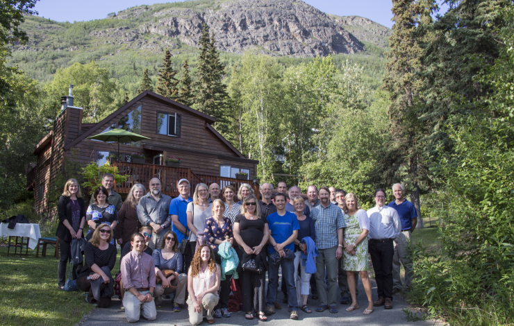
Principal investigators at the Arctic IERP meeting in Anchorage, AL.
PMEL scientists from the Ecosystems and Fisheries Oceanography Coordinated Investigations (EcoFOCI) program attended the first Principal Investigator meeting for the North Pacific Research Board (NPRB)’s five-year Arctic Integrated Ecosystem Research Program (Arctic IERP) in Anchorage, Alaska on June 20-23.
This historic Arctic Integrated Ecosystem Research Program will study the northern Bering and Chukchi Seas during spring through fall to better understand how changes in physical environmental drivers influence the structure and function of the biological system and access to subsistence resources. The EcoFOCI team (comprised of PMEL, AFSC, JISAO, and Bigelow Laboratory scientists) will lead the Oceanography and Lower Trophic Level Productivity portion of the program under the direction of Carol Ladd. The field seasons for this project are planned to begin in spring 2017 through the fall of 2019.
The goals of the meeting were to introduce the funded projects, discuss how these projects are connected, identify any gaps, come to a consensus on the overarching hypothesis for the integrated research, introduce PI's from other Arctic projects that may integrate with the Arctic IERP research, and discuss the framework for integration, data management, and communication/outreach during the project.
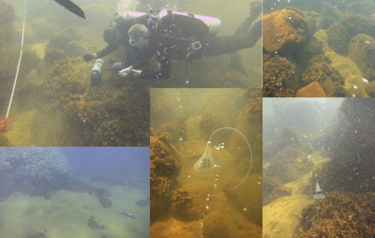
Sampling the hydrothermal fluids and gases in the caldera.
On June 29 at 8:30 pm EDT, an episode for the Changing Seas TV series will air on WPBT2 focusing on PMEL’s May 2014 expedition to Maug Island, about 450 miles north of Guam to study volcanic ocean acidification. Maug provides scientists with an extraordinary natural laboratory for ocean acidification research. Watch the full episode on the Changing Seas TV YouTube Channel. WPBT2, South Florida PBS, produced the episode along with Open Boat Films.
In May 2014, OAR/PMEL’s Earth-Ocean Interactions (EOI) group and NMFS/ Pacific Island Fisheries Science Center (PIFSC)’s Coral Reef Ecosystem Division led a week-long expedition on the NOAA ship Hi’ialakai to Maug Island in the northern Marianas to study the effects of ocean acidification on marine ecosystems. Maug is a flooded caldera where volcanic CO2 vents directly into a shallow coral reef ecosystem. The gas emitted by the vents change the chemistry of the seawater around the reefs in a process similar to global ocean acidification.
EOI scientists that were aboard the cruise included Pamela Barrett, David Butterfield, Nathan Buck and Ben Larson from the Joint Institute for the Study of the Atmosphere and Ocean at the University of Washington (UW) and Susanna Michael, a graduate student at UW's School of Oceanography.
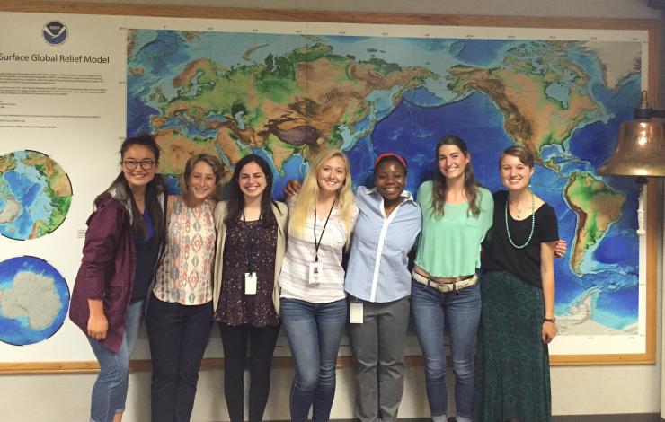
The 2015-2017 Hollings scholars at PMEL and OMAO. From left to right: Cordelia, Allison, Abigial, Audrey, Alfre, Leah and Meghan. Alfre Wimberley is a Hollings Scholar working in OMAO's small boats program. Not pictured: Gabriella
This summer, NOAA’s Pacific Marine Environmental Lab is mentoring six undergraduate Hollings scholars and one NSF research experience for undergraduates (REU) student. These students come from all over the United States and all have a passion for the marine environment. The summer internships provide each student with hands-on research experience as they work closely with a mentor. This year, the undergraduates are placed in the Acoustics, Arctic, Carbon, Ocean Climate Stations, Atmospheric Chemistry and Large Scale Ocean Physics groups and are located in Seattle, WA and Newport, OR.
We are very excited to have this year’s cohort: Abigail Birnbaum, Leah Chomiak, Allison Hogikyan, Gabriella Kalbach, Cordelia Sanborn-Marsh, Meghan Shea, and Audrey Taylor. Read more about each Hollings Scholar and our NSF-REU student on our education page.
Learn more about NOAA’s Ernest F. Hollings (Hollings) Undergraduate Program and the National Science Foundation Research Experience for Undergraduate (NSF-REU) program.
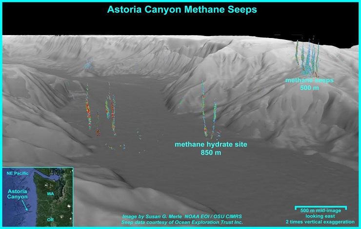
3D map of where the methane hydrate site was discovered on the seafloor of Astoria Canyon at 850 m. The exposed hydrate layer is up to 0.5 m thick. Image credit: Susan Merle
The Ocean Exploration Trust Inc. ship E/V Nautilus, with several NOAA-PMEL and Oregon State University CIMRS scientists aboard, is using the latest midwater sonar technology to map out methane seeps along the Cascadia continental margin this month. PMEL/CIMRS scientists report that, after locating extensive bubble plumes of methane in Astoria canyon at 850 m, the remotely operated vehicle Hercules visited the site and found an exposure of methane hydrate and gas bubbles streaming out of the seafloor. The hydrate, a mixed water/methane ice phase, is present over extensive areas of continental margins, but has only rarely been observed exposed at the seafloor along the Cascadia margin. Why the hydrate is exposed at this location in association with the methane gas seepage is a topic of discussion among the scientists aboard the Nautilus and those ashore participating remotely via the internet. The E/V Nautilus is a unique platform with extensive telepresence capability that enables scientist aboard to interact with those in the broader scientific community and the public ashore. Dives with the Hercules are broadcast live over the internet and can be viewed at http://www.nautiluslive.org/
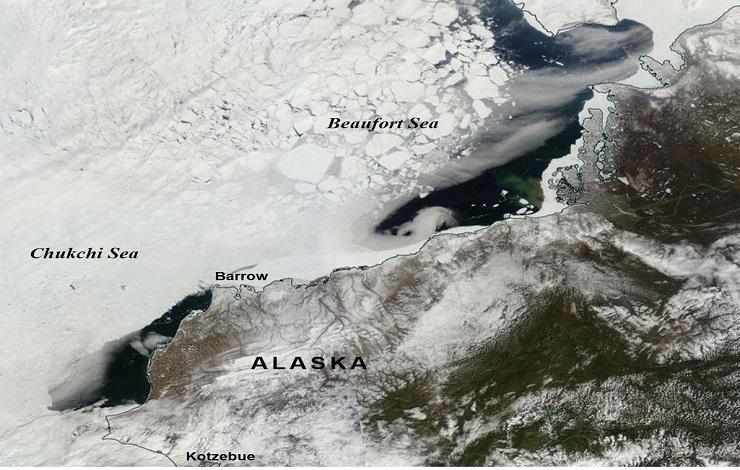
A satellite view of the Chukchi and Beaufort Seas on 19 May 2016, showing an exceptionally early and rapid sea-ice retreat along the Alaskan coast.
On June 5th, the Arctic Heat Open Science Experiment (Arctic Heat) began over the Chukchi and Beaufort Seas, in the Alaskan Arctic, to collect data to support sea ice and weather forecasting. PMEL will be leading flights aboard a specially-outfitted NOAA Twin Otter aircraft that will be operating during the summer to launch autonomous floats, MRV’s Air-Launched Autonomous Micro-Observer “ALAMO”, and to rapidly collect data over a wide area.
The Chukchi Sea and other seasonally ice-free marginal seas are among the most challenging regions to study because for much of the year the sea ice is not stable enough to deploy equipment on and it can easily wreak havoc on most instruments in the water. Ships and satellites only provide limited access to this domain, and so the progress of research is impeded by the lack of observations.
Arctic Heat is a joint effort of NOAA Pacific Marine Environmental Laboratory (PMEL) Arctic Research, the Innovative Technology for Arctic Exploration (ITAE) program, the ALAMO development group at the Woods Hole Oceanographic Institution, and the Joint Institute for the Study of the Atmosphere and Ocean (JISAO) at the University of Washington.
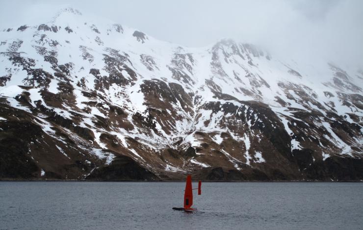
Through September, PMEL and Alaska Fisheries Science Center (AFSC) are testing innovative technologies to survey the Bering Sea. PMEL is once again utilizing the Saildrone, a solar and wind powered unmanned autonomous vehicle developed by Saildrone Inc., as a research platform. Two Saildrones launched from Dutch Harbor, AK on May 23, each equipped with suites of meteorological and oceanographic sensors, plus specially developed echo sounders and modified whale acoustic hydrophones.
Following the successful 2015 oceanographic field trials, the 2016 mission combines both physical and biological oceanography to seek out new ways to supplement traditional vessel-based research. Oceanographic and fisheries data will be validated to the NOAA Ship Oscar Dyson and PMEL moorings.
Watch the YouTube Broadcast to hear more from the scientists involved. Read more about the mission here and at NOAA Research.
Follow along with the saildrone on the Innovative Technology for Arctic Exploration site.
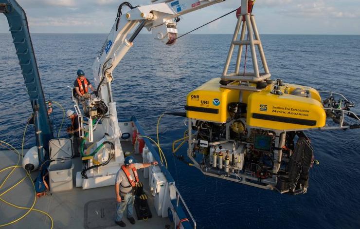
Launching Hercules off stern of E/V Nautilus. www.nautiluslive.org
PMEL scientists from the Earth-Ocean Interactions Program will be on board the E/V Nautilus, which is operated by the Ocean Exploration Trust (OET), during June 1-20. This expedition will explore and characterize habitats and methane seeps along the Cascadia continental margin between northern Washington and Cape Mendocino. Broadband video of the seafloor during the dives from OET remotely operated vehicle Hercules will be broadcast in realtime over the internet. Scientists ashore representing a broad range of expertise will also participate via a realtime link to the ship during the dives.
Follow along live and learn more about the cruise on: http://www.nautiluslive.org