What's New Archive
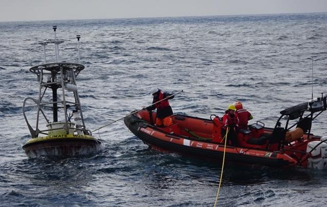
Personnel from NOAA's Pacific Marine Environmental Lab participated in a research cruise aboard the Canadian Coast Guard Ship JOHN P. TULLY, and recorded some great videos of mooring operations. Watch the two short videos at the end of this article, to see the deployment of one climate mooring, and the recovery of the buoy that had been in the water for a year. Get a first hand look at a day in the life of a NOAA buoy technician!
On this trip, the ship sailed out of Sidney, B.C. on June 7, 2015, and returned to port on June 22nd. As part of the science mission, the crew performed water sampling and net tows to study ocean physics, chemistry, and zooplankton. Ten NOAA drifter floats, used to study ocean currents, were also deployed. While the ship was still offshore, an important algal bloom was detected along the coast of North America. Ship's personnel were able to collect additional water samples in coastal waters, to verify the extent of the bloom in Canadian waters.
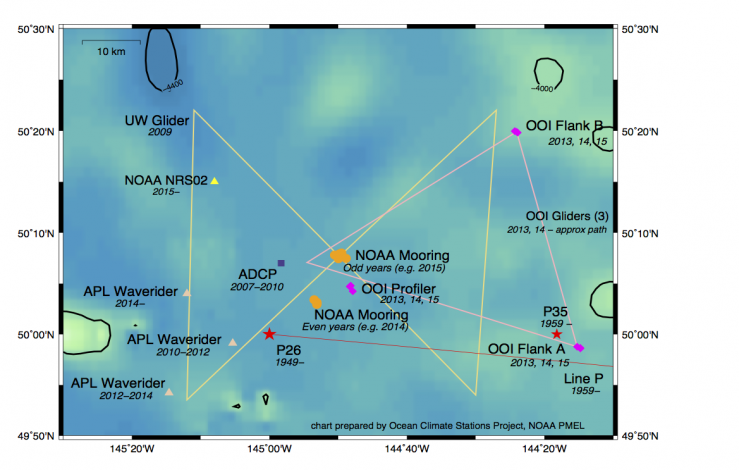
The ship spent several days at a site in the Gulf of Alaska, called Ocean Station Papa. Beginning in December 1949, Ocean Station Papa (50°N, 145°W) was occupied by a Weather Ship operated through the U.S. Coast Guard by the U.S. Weather Bureau. The site was taken over by a Canadian Weather Ship in December 1950, and several years later oceanographic measurements began to be routinely made. Though no longer under continuous observations by Weather Ships, the Canadian Institute of Ocean Sciences has been making trips to the site three to six times per year since 1981.
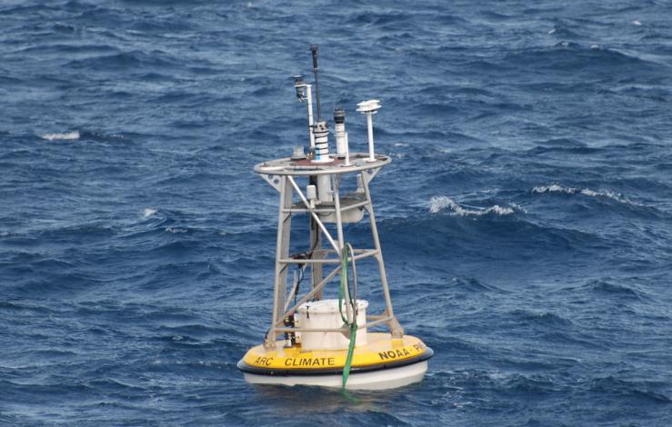
In 2007, the OCS program deployed their first surface mooring at Ocean Station Papa, which now uses satellite technologies to transmit weather and climate data to shore. This mooring took on the role of those old Weather Ships, and the climate record from Ocean Station Papa is one of the oldest on record. Watch videos showing how these moorings are deployed and recovered.
By: Jennifer Keene
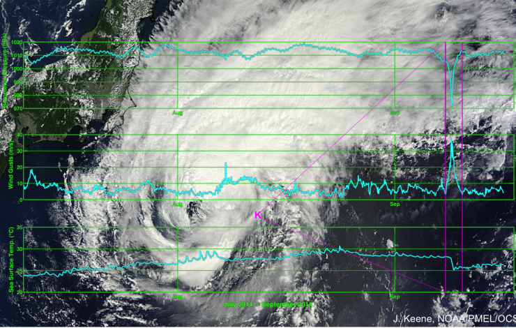
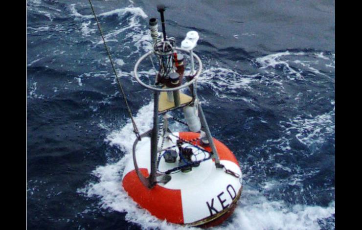
The tropical cyclone Fengshen, named for the god of wind in Mandarin Chinese, passed over the NOAA mooring at the Kuroshio Extension Observatory (KEO) on September 8-9, 2014 GMT. The KEO mooring is located off the coast of Japan, where tropical cyclones and typhoons pass regularly during the autumn storm season. KEO has been specially adapted to be a "storm mooring," built to withstand extreme conditions, and also send data back to shore once per hour to allow scientists to monitor events in near real-time.
The buoy functioned exactly as planned throughout the storm, and a complete data record was captured. Barometric pressure dropped to a low of 971.5 hPa during the storm, and wind gusts reached 37 m/s (83 mph). The sea surface temperature dipped drastically from around 28°C to almost 25°C in just a few hours due to enhanced mixing of surface waters with cooler waters below.
With access to typhoon data in near real-time, scientists are able to verify and improve the accuracy of forecasts and storm prediction models. Researchers from NOAA's Pacific Marine Environmental Lab (PMEL), who deployed the KEO mooring, are working with partners at the NOAA's Environmental Modeling Center (EMC) to do just that. Model improvements can also be applied to hurricane forecasts for storms that might impact the east coast of the U.S.
The PMEL KEO mooring is part of a global network of time series reference stations. It carries a suite of sensors to monitor the ocean-atmosphere exchanges of heat, moisture, momentum and CO2, ocean acidification, and the upper ocean physical state. Deep ocean temperature and salinity are also measured by an instrument just above the sea floor.
By: Jennifer Keene
Additional articles:
NASA Sees Tropical Storm Fengshen Looking More Like a Frontal System NASA web page
What Happens Underwater During a Hurricane? University of Miami, Rosensteil School of Marine & Atmospheric Science web page
Researchers at NOAA's Pacific Marine Environmental Laboratory (PMEL) and the University of Washington Joint Institute for the Study of Atmosphere and Oceans (JISAO) are watching with great interest as an area of warm surface water persists in the North Pacific.
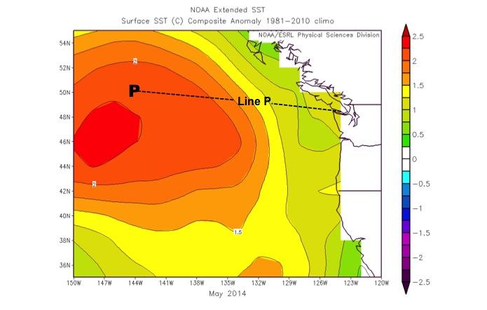
During the fall and early winter of 2013 – 2014, residents of the Pacific Northwest enjoyed more dry weather than normal, with fewer and weaker storms. The weaker than usual winds resulted in reduced heat transfer between the air and ocean, less mixing of cold water from below, and reduced transport of warm water toward the equator. This left a large mass of warm water in the Northeast Pacific, nicknamed "The Blob." At its core, the water mass was ~3°C above normal temperatures in February 2014, and it is still prominent going into the summer months.
The PMEL Ocean Climate Stations (OCS) project Station Papa buoy ismoored in the heart of the blob, making continuous measurements of the atmosphere and ocean at this site since 2007. The Office of the Washington State Climatologist and other OCS scientists will use data from the mooring to evaluate the ocean processes related to the causes and effects of this warmer than usual water mass. PMEL researchers are also onboard a Canadian research vessel that will be servicing the mooring and taking measurements along "Line P" June 8 – 24, 2014.
According to climate models, the region of warm surface water may continue to be well above normal temperatures through late summer 2014. This could affect regional weather, as well as marine ecosystems. The weather could be warmer and more humid than normal, and more thunderstorms may develop. In the marine ecosystem, the warmer water provides more favorable habitat for tuna near the coast, but may adversely affect juvenile salmon through reduced supply of nourishing food sources.
By: Jennifer Keene
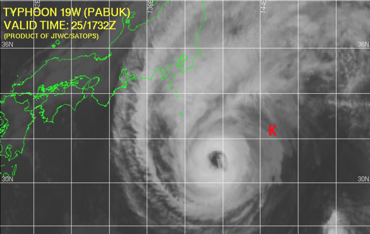
Typhoon Pabuk, a category 1 tropical cyclone, passed 80 km to the west of NOAA's Kuroshio Extension Observatory (KEO) mooring on 26 September 2013. This was followed by Typhoon Wipha on 15 October 2013, and Francisco on 26 October 2013.
The measurements collected during Typhoon Pabuk will constitute one of the most comprehensive data sets of ocean conditions on the eastern side of a tropical cyclone. In particular this data set will provide the opportunities for comparisons with the conditions observed by KEO during the passage of Typhoon Choi-Wan on 19 September 2009. During that storm, KEO was ~ 40 km to the west of the eye. Both Choi-Wan and Pabuk were beginning to transition to extratropical storms as they passed KEO, much as Hurricane Sandy was when it made landfall.
The other two storms passed farther to the north of the KEO mooring. Interesting and meaningful data were acquired from the outer edges of these storms. Analysis of air-sea interactions at KEO during the passage of typhoons will contribute to better understanding and prediction of tropical cyclones worldwide.
The PMEL KEO mooring is part of a global network of time series reference stations. It carries a suite of sensors to monitor the ocean-atmosphere exchanges of heat, moisture, momentum and CO2, ocean acidification, and the upper ocean physical state. Because of the strong currents, relatively frequent tropical cyclones (typhoons), and powerful winter storms, KEO is designed for rugged conditions.
By: Jennifer Keene
The ocean is starting to get crowded around Ocean Station Papa, and PMEL's Ocean Climate Stations (OCS) project gains yet another science partner.
Climate studies have been conducted almost continuously at Ocean Station Papa (50°N, 145°W) since 1949, and OCS has had a surface mooring deployed at this site since June 2007. The OCS mooring is now the primary climate observing platform at the site, and includes a full suite of meteorological sensors, as well as subsurface instruments to 300m. The OCS mooring carries a system to measure CO2 flux, through a partnership with PMEL's Carbon Program. Additional instruments on the bridle used for oxygen measurements are supplied by partners at the University of Washington. A deep temperature/conductivity/pressure sensor has been deployed just above the anchor in recent years, through a partnership with the OceanSITES project. Water sampling and CTD casts at the mooring site and enroute from the Canadian coast, plus ship time for servicing the moorings, are provided through a partnership with Canada's Department of Fisheries and Oceans Line P program. Since 2010, wave height, periodicity, and direction have been measured by a nearby WaveRider mooring maintained by partners at the UW Applied Physics Laboratory.
The newest partner to join the outstanding research being done at Ocean Station Papa is the Ocean Observatories Initiative (OOI). In July 2013, OOI deployed two additional flanking moorings, a nearby profiling mooring, and three gliders at the site. The deployment at Station Papa is the first of several planned global nodes for the OOI project. Uniquely at this site, the OCS mooring will serve as the central mooring of the OOI array, providing all meteorological data and additional subsurface measurements.
By: Jennifer Keene
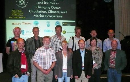
The American Geophysical Union (AGU) Chapman Conference on "The Agulhas System and its Role in Changing Ocean Circulation, Climate, and Marine Ecosystem," was held in Stellenbosch, South Africa, October 8-12, 2012. Chapman conferences are small meetings, designed to allow participants to reach detailed levels of discussion about specialized subjects.
The Agulhas System conference brought together scientists from around the world. The goals were to identify the most pressing questions and design modeling experiments that would allow researchers to learn more about the role of the Agulhas system in climate from regional to global scales.
While attending the conference, PMEL's Dr. Meghan Cronin visited Sophumelela High School in the township of Phillipi in South Africa recently. Her experience is described below:
Through efforts of Juliet Hermes and Thomas Mtontsi of SAEON, Dr. Meghan Cronin (NOAA) and Prof. Lisa Beal (U. Miami) were able to visit Mr. Ndemane's science classes (~ 60 learners) at Sophumelela High School in the township of Phillipi on the Cape Flats outside of Cape Town. Meghan Cronin's 13-year-old daughter, Fiona McCully, also went into a classroom for peer-to-peer discussions.
A small group of Mr. Ndemane's class have been involved in SAEON's Learner program, and the full class was involved in the NOAA Adopt A Drifter program (ADP). As part of the NOAA ADP, 3 pairs of drifters were deployed in the Agulhas Current. During the presentation, Cronin and Beal introduced ocean currents to the Learners and their impact on sea surface temperature (SST) and climate. After showing a movie of the Agulhas system's SST produced from a numerical model at NOAA GFDL, the learners were asked which ocean the drifters would end up in and whether and when the drifter pairs would separate. Results of the experiment were then presented: 5 of the 6 drifters ended up in the S. Indian Ocean.
In one pair, one drifter ended up in the S. Atlantic Ocean and one ended up in the S. Indian Ocean.
Data from these drifters contribute to the NOAA Global Drifter Program (GDP), a component of the Global Ocean Observing System, and can be viewed from both the GDP webpage and the NOAA ADP webpage .
Cronin presented a poster on the NOAA ADP at the Chapman Conference, which included co-authors from NOAA, SAEON, South Africa Weather Service, ASCLME, and Globe Africa. A University of Cape Town student will be lead author on a scientific manuscript describing this drifter experiment. The Sophumelela High School learners were clearly engaged by the visit. At the end, one learner stood up and thanked Cronin and Beal for encouraging them to be scientists and believing that it was possible. Another learner from the SAEON program came up afterwards to ask for advice on a science fair project on climate change. In turn, as a thank you for being invited into the classes, Cronin gave a personal gift of DK Reference World Atlases to the classes and to Mr. Mtontsi, and Beal gave a personal gift of blow up Earth globes with currents marked on the oceans.
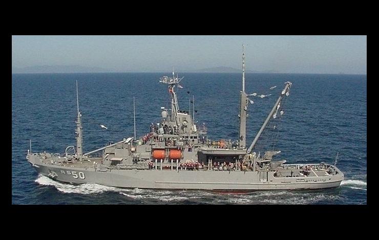
An innovative partnership between NOAA and the US Navy brings research scientists one step closer to understanding the intricate relationship between the atmosphere and ocean that will help lead to improved predictability of weather, global climate, and changes in the ocean environment. On Nov 14th, scientists from NOAA's Pacific Marine Environmental Laboratory (PMEL), onboard the US Navy's Military Sealift Command ship USNS SAFEGUARD deployed an upgraded Ocean Climate Station Mooring on the southern edge of the Kuroshio Extension Current, 340 miles SE of Tokyo, Japan. The crew of the USNS SAFEGUARD successfully and safely deployed the 9 ft diameter surface buoy, which weighs 2900 lbs, and the 5 miles of wire and nylon line used to anchor the mooring in 18,700 feet of water.
The KEO mooring carries meteorological and physical sensors to monitor winds, air temperature, relative humidity, barometric pressure, near-surface currents, and ocean temperatures and salinity to a depth of 1720 feet. This heavily instrumented surface mooring was designed, built, and deployed by NOAA's PMEL to add to the global network of OceanSITES time series reference sites.
The ship time needed to safely service this mooring, and to recover the prior mooring with its load of expensive sensors and irreplaceable data, was made available through a joint partnership between NOAA and the United States Navy's Military Sealift Command. USNS SAFEGUARD (T-ARS-50), a 255-foot salvage vessel assigned to the Naval Fleet Auxiliary Force stationed with the US Navy's 7th Fleet out of Yokosuka, Japan, is a U.S. ship already stationed in the area, thus reducing the overall expense of maintaining this ocean observatory.
NOAA's mission is to understand and predict changes in the Earth's environment, from the depths of the ocean to the surface of the sun, and to conserve and manage our coastal and marine resources. KEO is funded by the NOAA's Climate Program Office
To better understand the effects of the ocean on global climate and weather, scientists from NOAA’s Pacific Marine Environmental Laboratory, or PMEL, deployed an Ocean Climate Station mooring — an anchored buoy —on the edge of the warm Agulhas Return Current (ARC) southeast of South Africa. Although there is an array of climate buoys positioned in the tropics, this is one of only two deep ocean climate buoys positioned below the Tropic of Capricorn; the other is located south of Australia. The buoy is part of NOAA's climate observation and monitoring efforts.
“With this mooring, we will be able to measure how this powerful current warms the atmosphere and some of the effects this has on the local meteorology and climate,” said Meghan Cronin, Ph.D., principal investigator and oceanographer at PMEL. “More heat is released to the atmosphere in the ARC region than anywhere else in the entire Southern Hemisphere. This heating can affect winds, clouds and rainfall over a broad region.”
The ARC is a western boundary current, similar to the Gulf Stream in the North Atlantic and the Kuroshiro Extension in the North Pacific. With support from NOAA and the National Science Foundation, NOAA’s PMEL designed, built and deployed the heavily instrumented ARC surface mooring to monitor weather and compute the heat absorbed and released by this region of the ocean. Sensors include those that measure wind, air temperature, relative humidity, rain, solar and infrared radiation, barometric pressure, sea surface temperature and salinity, and near-surface currents.
“The buoy will also carry sensors to measure how much atmospheric carbon dioxide is absorbed into the ocean in this critical region for the global climate system,” said Christopher Sabine, Ph.D., oceanographer at PMEL and participant in the ARC project.
“Building a buoy to collect and transmit reliable data requires teamwork between the engineers and the scientists,” said Chris Meinig, director of PMEL engineering, whose group designed and built the buoy. “Because of the location off South Africa, we had to carefully design, model and build something that has a chance of withstanding the violent weather, steep waves and strong currents.”
With the use of ship time provided by the Agulhas and Somali Current Large Marine Ecosystems Project, the mooring was deployed in 4,300 meters (12,900 feet) of water using the South African Fisheries Research Ship Algoa. Data are relayed to shore in near-real time and made available through PMEL and other climate and weather data centers. The ARC buoy is a member of the family of Ocean Climate Stations, which include Kuroshio Extension Observatory located east of Japan and Station Papa located in the Gulf of Alaska. These moorings act as reference stations for validating satellite observations and improving weather forecasting and climate models.
The FRS Algoa also deployed two free-floating buoys, or drifters, provided by the NOAA Adopt-a-Drifter program, which will be part of the Global Drifter Array. These drifters measure surface temperature, current velocity and atmospheric barometric pressure. Students from Washington state and South Africa will track the drifters online and try to predict where they might go and why.
Classroom participation within Africa is being coordinated through a partnership between NOAA, ASCLME, Global Learning and Observations to Benefit the Environment-Africa, the South African Weather Service and the South African Environmental Observation Network.
NOAA’s mission is to understand and predict changes in the Earth's environment, from the depths of the ocean to the surface of the sun, and to conserve and manage our coastal and marine resources. Find us online and on Facebook.
On Sunday November 6, 2005 at approximately 1500 UTC, a NOAA/PMEL moored buoy known as the Kuroshio Extension Observatory (KEO) broke away from its anchor and began drifting southeastward at 0.5 knots. The KEO buoy, moored in 6 km of water in the Kuroshio Extension recirculation gyre, 300 miles offshore of Japan, carries a full suite of meteorological and subsurface sensors, as well as sensors to monitor the carbon dioxide uptake by the ocean. Each day, daily averages of all surface measurements and most subsurface measurements are telemetered by satellite to PMEL via Service ARGOS. In addition to the daily-averages, 8-13 times per day surface meteorological samples and buoy positions are transmitted. Thus, PMEL scientists were aware of a problem within hours of the break and took action to assess the situation and to apprise Japanese colleagues and investigate the possibility of a rescue operation. As luck would have it, Dr. Hiroshi Ichikawa, from the Japan Agency for Marine-Earth Science and Technology (JAMSTEC) had just left port aboard the R/V Kaiyo to do work in the Shikoku Basin. Dr. Ichikawa, JAMSTEC’s group leader for the Kuroshio Transport and Surface Flux group, immediately made arrangements to revise his cruise plan and within hours was heading full-steam towards the drifting buoy. Two days later, the mooring was successfully recovered.
The KEO buoy is an element of the Global Earth Observation System of Systems (GEOSS), which has been signed by nearly 60 nations. The data transmitted from this site are publicly available and are used by scientists worldwide. Its loss is an unfortunate hazard of working in severe conditions in the remote open ocean. But thanks to the fast action by JAMSTEC and the fact that the break occurred below the deepest sensor, all of the equipment was recovered in good condition and the high resolution data stored by the buoy were saved. The KEO rescue is greatly appreciated and a tribute to the long history of collaboration between JAMSTEC and NOAA.


