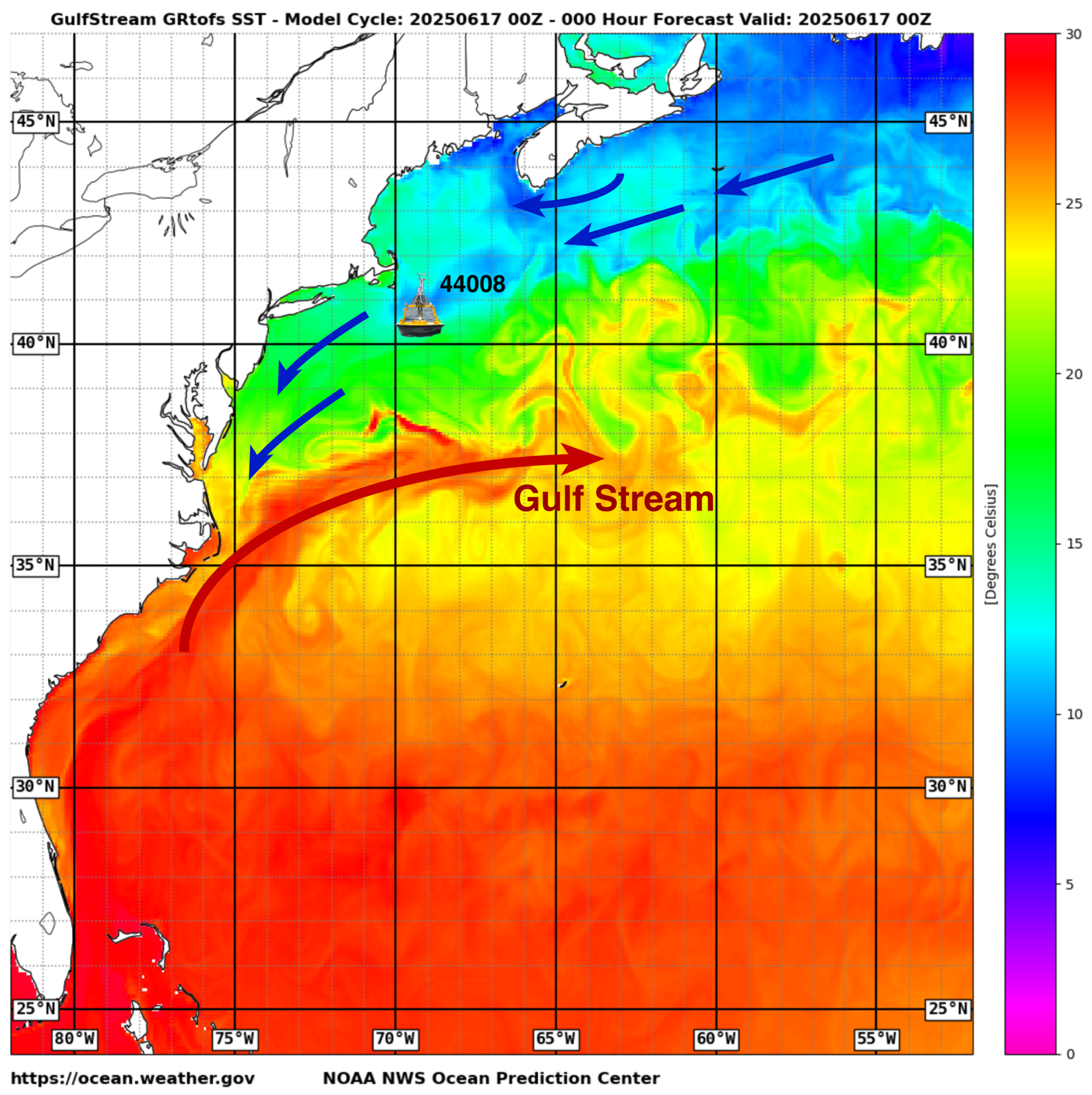
Approximate location of the enhanced NDBC 44008 weather buoy shown overlaid on an analysis of sea surface temperature in degree Celsius for 17 June 2025 from the NOAA Global RTOFS high resolution ocean model. The blue arrows indicate the return surface flow north of the Gulf Stream, with the larger red arrow depicting the Gulf Stream. Image Credit: NOAA Ocean Prediction Center, modified by Y. Serra to show buoy and current arrows.
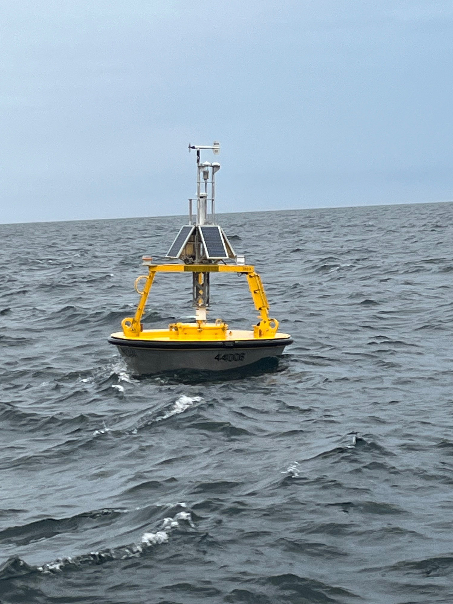
Enhanced weather buoy 44008 deployed on 9 May 2025 at 40.50°N 69.25°W. Photo courtesy of James Elliott, NDBC.
On May 9, 2025, a research-enhanced weather buoy was deployed at 40.50°N 69.25°W for an expected observing period of one year. Working alongside a team of engineers and technicians at the National Data Buoy Center (NDBC), Dr. Yolande Serra's (UW/CICOES) project has enhanced weather buoy 44008 with additional surface and subsurface sensors. The station, located on the New England shelf on the north side of the core Gulf Stream current in 72 meters of water, has standard measurements of wave height and period, sea surface temperature, wind speed and direction, air temperature, humidity, and surface pressure available from all NDBC operational weather buoys. This project's enhancements include a current meter at 3 meter depth, subsurface temperature, salinity, and pressure sensors distributed at depths from 5 to 55 meters, an upward looking acoustic doppler current profiler at 55 meter depth, and upward looking solar and infrared radiometers mounted on the buoy tower.
With the addition of the radiation sensors, the weather buoy now provides all the components of the surface ocean heat budget, while the subsurface temperature and salinity sensors provide information about the heat content and depth of the surface mixed layer. We can additionally learn about ocean mixing and advection of heat and water properties from the wind, wave, and current measurements. Together, the added observing capabilities provided through this pilot study could lead to better understanding and prediction of the ocean's influence on storm development impacting the northeastern US, as well as marine heatwaves, coastal circulation, and ocean eddies.
While the operational data are distributed through NDBC’s standard webpage, "enhancement" data are pulled to PMEL servers and served via a NOAA/PMEL public data access portal. This project is located about 65 nautical miles east of the US National Science Foundation Ocean Observatories Initiative (OOI) Coastal Pioneer New England Shelf Array, a 5-year research program that collected detailed ocean and air-sea interface observations of the New England shelf from 2017 to 2022, providing important context for our 1-year pilot study. The data collected by our project are aligned with the data needs of the National Weather Service (NWS), Northeastern Regional Association of Coastal Ocean Observing Systems (NERACOOS), and Mid-Atlantic Regional Association Coastal Ocean Observing System (MARACOOS), with additional potential data users within the fishing and wind energy communities. The future of the enhanced weather buoy concept will be explored through surveys of our primary data users following the outcome of this pilot study and the ongoing needs of the US coastal communities.
The "Pilot Upgrade of NOAA NDBC Coastal Weather Buoys for Improved Monitoring of Weather and Climate", led by Dr. Yolande Serra (UW/CICOES) as a joint UW/CICOES, NOAA/NWS/NDBC, and NOAA/PMEL project, was funded by NOAA's Weather Program Office (WPO) grant number NA23OAR4590404. This project is in alignment with the Weather Forecasting and Innovation Act of 2017 (Public Law 115-25), which aims to improve NOAA's weather research through "investment on affordable and attainable advances in observational, computing, and modeling capabilities".
PI, Co-PIs and Project Affiliates:
Yolande Serra - UW/CICOES
Meghan Cronin - NOAA/PMEL
Dongxiao Zhang - NOAA/PMEL and UW/CICOES
Ian Sears - NOAA/NDBC
James Elliott - NOAA/NDBC
Nathan Anderson - NOAA/PMEL and UW/CICOES
Patrick Berk - NOAA/PMEL and UW/CICOES