What's New Archive
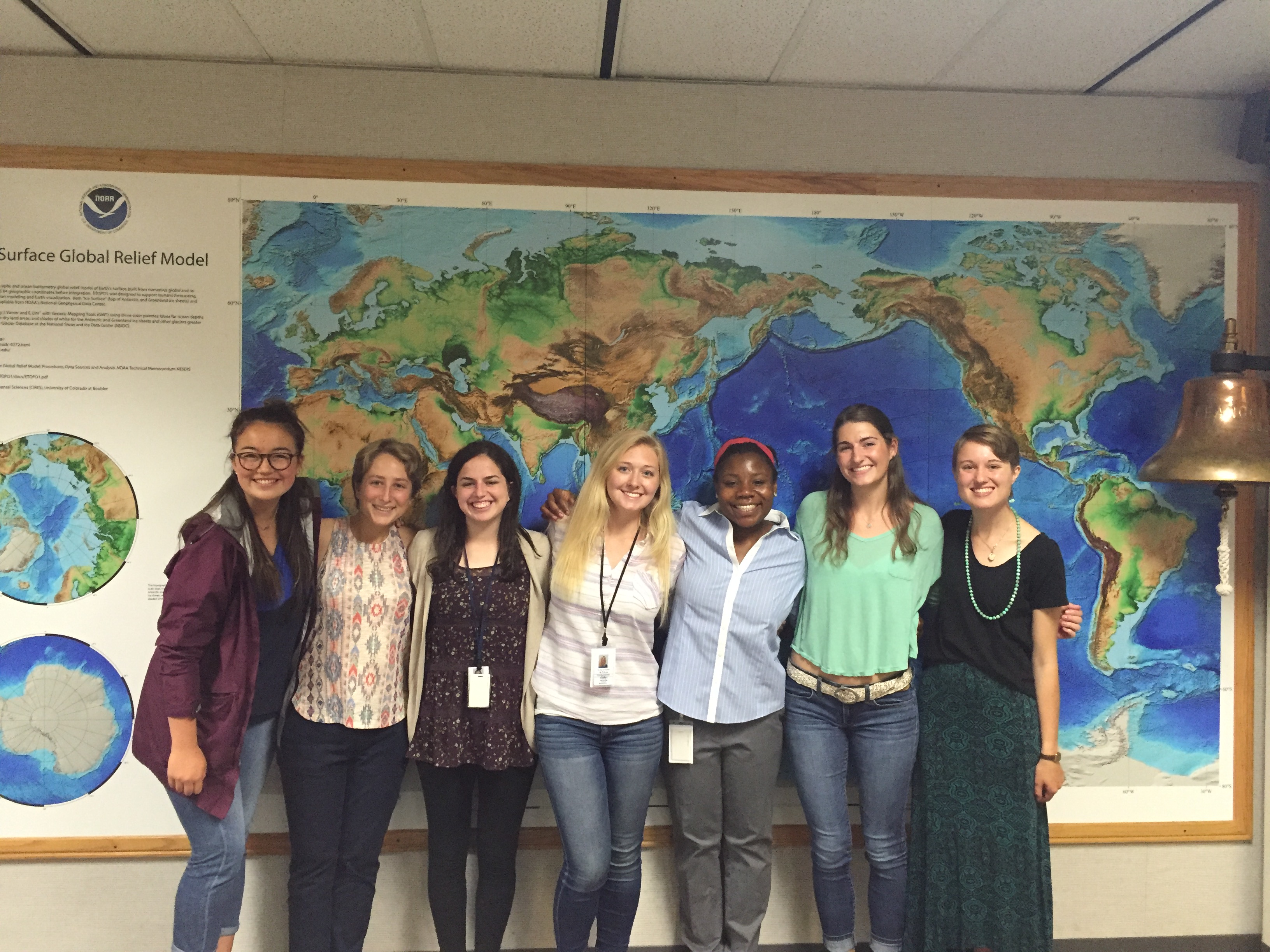
The 2015-2017 Hollings scholars at PMEL and OMAO. From left to right: Cordelia, Allison, Abigial, Audrey, Alfre, Leah and Meghan. Alfre Winmberley is a Hollings Scholar working in OMAO's small boats program. Not pictured: Gabriella
This summer, NOAA’s Pacific Marine Environmental Lab is mentoring six undergraduate Hollings scholars and one NSF research experience for undergraduates (REU) student. These students come from all over the United States and all have a passion for the marine environment. The summer internships provide each student with hands-on research experience as they work closely with a mentor. This year, the undergraduates are placed in the Acoustics, Arctic, Carbon, Ocean Climate Stations, Atmospheric Chemistry and Large Scale Ocean Physics groups and are located in Seattle, WA and Newport, OR.
We are very excited to have this year’s cohort: Abigail Birnbaum, Leah Chomiak, Allison Hogikyan, Gabriella Kalbach, Cordelia Sanborn-Marsh, Meghan Shea, and Audrey Taylor. Read more about each Hollings Scholar and our NSF-REU student on our education page.
Learn more about NOAA’s Ernest F. Hollings (Hollings) Undergraduate Program and the National Science Foundation Research Experience for Undergraduate (NSF-REU) program.
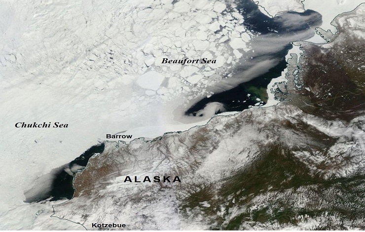
A satellite view of the Chukchi and Beaufort Seas on 19 May 2016, showing an exceptionally early and rapid sea-ice retreat along the Alaskan coast.
On June 5th, the Arctic Heat Open Science Experiment (Arctic Heat) began over the Chukchi and Beaufort Seas, in the Alaskan Arctic, to collect data to support sea ice and weather forecasting. PMEL will be leading flights aboard a specially-outfitted NOAA Twin Otter aircraft that will be operating during the summer to launch autonomous floats, MRV’s Air-Launched Autonomous Micro-Observer “ALAMO”, and to rapidly collect data over a wide area.
The Chukchi Sea and other seasonally ice-free marginal seas are among the most challenging regions to study because for much of the year the sea ice is not stable enough to deploy equipment on and it can easily wreak havoc on most instruments in the water. Ships and satellites only provide limited access to this domain, and so the progress of research is impeded by the lack of observations.
Arctic Heat is a joint effort of NOAA Pacific Marine Environmental Laboratory (PMEL) Arctic Research, the Innovative Technology for Arctic Exploration (ITAE) program, the ALAMO development group at the Woods Hole Oceanographic Institution, and the Joint Institute for the Study of the Atmosphere and Ocean (JISAO) at the University of Washington.
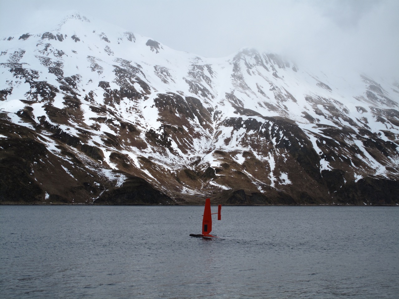
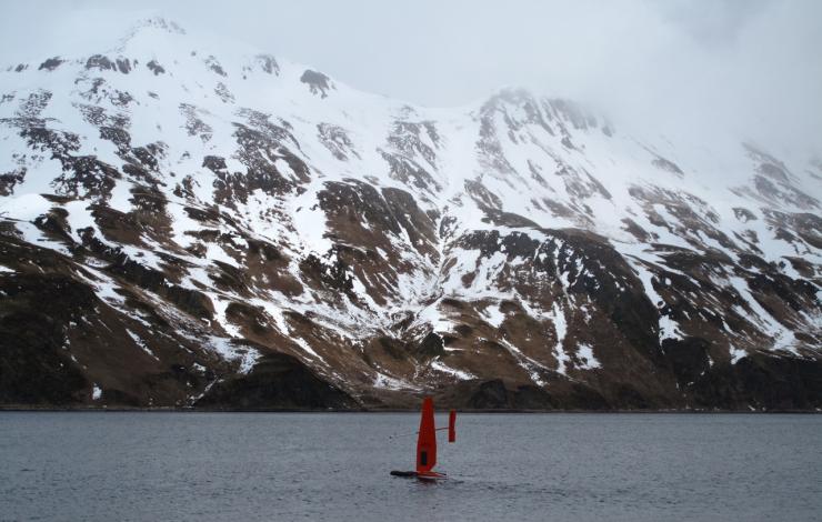
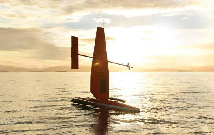
Through September, PMEL and Alaska Fisheries Science Center (AFSC) are testing innovative technologies to survey the Bering Sea. PMEL is once again utilizing the Saildrone, a solar and wind powered unmanned autonomous vehicle developed by Saildrone Inc., as a research platform. Two Saildrones launched from Dutch Harbor, AK on May 23, each equipped with suites of meteorological and oceanographic sensors, plus specially developed echo sounders and modified whale acoustic hydrophones.
Following the successful 2015 oceanographic field trials, the 2016 mission combines both physical and biological oceanography to seek out new ways to supplement traditional vessel-based research. Oceanographic and fisheries data will be validated to the NOAA Ship Oscar Dyson and PMEL moorings.
Watch the YouTube Broadcast to hear more from the scientists involved. Read more about the mission here and at NOAA Research.
Follow along with the saildrone on the Innovative Technology for Arctic Exploration site.
Through September, PMEL and Alaska Fisheries Science Center (AFSC) are testing innovative technologies to survey the Bering Sea. PMEL is once again utilizing the Saildrone, a solar and wind powered unmanned autonomous vehicle developed by Saildrone Inc., as a research platform. Two Saildrones launched from Dutch Harbor, AK on May 23, each equipped with suites of meteorological and oceanographic sensors, plus specially developed echo sounders and modified whale acoustic hydrophones.
Following the successful 2015 oceanographic field trials, the 2016 mission combines both physical and biological oceanography to seek out new ways to supplement traditional vessel-based research. Oceanographic and fisheries data will be validated to the NOAA Ship Oscar Dyson and PMEL moorings.
Tune into a live broadcast about the mission FRIDAY June 3 at 11 am pacific time here
Follow along with the saildrone on the Innovative Technology for Arctic Exploration site.
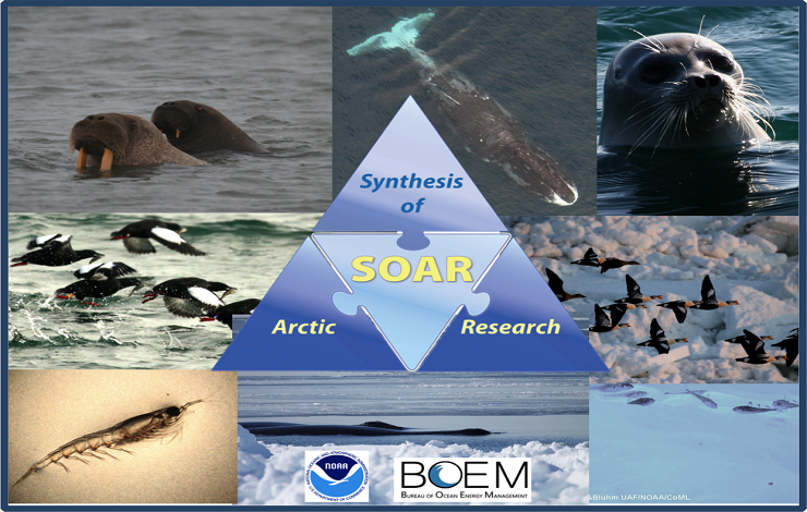
SOAR provides a holistic view of recent changes in the Pacific Arctic marine ecosystem.
The Synthesis of Arctic Research (SOAR) project published an update on May 9, 2016 that highlights how the Pacific Arctic’s new normal conditions are affecting a variety of marine life. SOAR is 6-year interdisciplinary effort led by PMEL and Fisheries scientists that provides a synthetic view of recent changes in the Pacific Arctic marine ecosystem. These recent changes include longer open-water periods during the summer, fewer days of sea ice cover, reduced sea ice thickness, increased growing season of marine algae and lower pH. A second Special Issue is currently underway and builds on themes and new understanding described in the first Special Issue that featured 17 papers from over 100 contributors.
Through collaboration and synthesis, SOAR is increasing scientific understanding of the complex relationships among oceanographic conditions (physics, chemistry, sea ice), and species in various levels of the food web (from zooplankton and forage fish to seabirds and marine mammals), in the rapidly changing Pacific Arctic marine ecosystem.
Read the project update on Eos, the news arm of the American Geophysical Union.
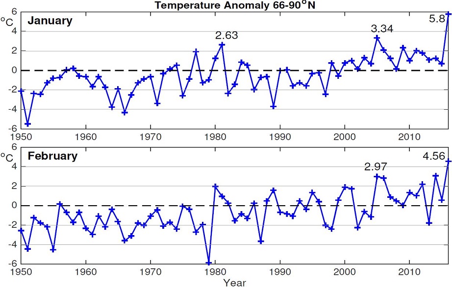
These graphs show the January and February surface air temperature anomaly averaged over the Arctic area (66–90°N) based on NCEP/NCAR Reanalysis. Units are in °Celsius.
Right from the beginning of 2016 new records have been set in the Arctic: warmest air temperature on record in both January and February, and the lowest sea ice cover in February. The average temperature anomaly has reached a record of 5.8°C (10.4°F) for January and 4.56°C (8.2°F) for February. This is the warmest period in the Arctic for these two consecutive months since 1948. The Arctic sea ice extent for February 2016 averaged 14.2 million square kilometers (5.5 million square miles), the lowest February extent in the satellite record. Once Arctic scientists at PMEL put this past January and February into historical perspective, they saw that this unusual warmth is unprecedented in both months. This unprecedented warmth is mainly due to the large positive temperature anomalies in the Arctic Ocean and over the North American continents. This year’s record high temperature and low sea ice cover increases concerns about what will happen next in the Arctic and globally.
Read the full story on NOAA Arctic theme page.
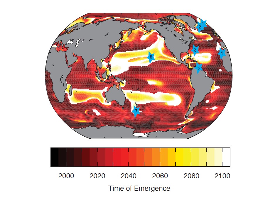
This map shows the timeframe (year) in which the anthropogenic trend becomes distinguishable from internal climate variability. The darker red indicates earlier emergence of the trend while the orange/white areas show emergence later on. The blue stars indicate current ocean carbon sampling locations.
The ocean absorbs a significant fraction, about 40%, of carbon released by fossil fuel burning, thereby reducing climate warming. However, natural climate variability makes it difficult to directly observe trends in the amount of anthropogenic carbon the ocean is taking up with time. PMEL scientist and collaborators utilized a modeling approach to separate out the ocean carbon trend due to man-made carbon emissions from this variability. This separation illustrates the timeframe over which we may expect to observe human driven change in carbon uptake in different ocean regions. The results show that these trends are largely not detectable at present, but may begin to emerge in certain regions between 2020-2050. The Southern Ocean and Atlantic region are projected to show this uptake first, while the latest emergence occurs in the Pacific and Indian subtropical regions.
For more information, read the article in Nature, along with Nature's News and Views, a press release from the University of Wisconsin and visit the NOAA PMEL Arctic project webpage.
In 2015, Arctic sea ice reached a maximum extent on 25 February, 15 days earlier than average and the lowest value on record (1979-present). Minimum ice extent in September was the 4th lowest on record. Sea ice continues to be younger and thinner than it was 30 years ago. Changes in sea ice alone are having profound effects on the marine ecosystem (fishes, walruses, primary production) and sea surface temperatures.
Melting occurred over more than 50% of the Greenland Ice Sheet for the first time since the exceptional melting of 2012, and glaciers terminating in the ocean showed an increase in ice velocity and decrease in area. Terrestrial vegetation productivity has been decreasing since 2011.
Read the NOAA Press Release and the complete 2015 Arctic Report Card released today.
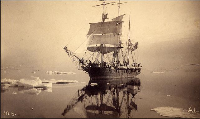
In the Crow's Nest, watching for a 'blow'. "Thar she blows". Photo courtesy of the New Bedford Whaling Museum.
Citizen scientists have a new opportunity to help reconstruct past climate by transcribing data from whaling ship logs. A massive collaboration among government and university scientists, archivists and museum curators, has unveiled Old Weather: Whaling, a sister project of Old Weather that is focused on the Pacific Arctic whaling industry that began in 1849. Volunteers mine massive amounts of sea-ice and weather data from the ship’s logs -- along with amazing stories of the Arctic whalemen. These data are fed to state-of-the-art retrospective analysis (reanalysis) systems and provide ground-truth for sea-ice and climate models, all contributing toward better understanding of the Arctic climate of the future.
Read more about Old Weather and Old Weather: Whaling as well as feature stories on NOAA Research and UW Today from the University of Washington.
The autonomous wind-powered and remotely-controlled Saildrone tested data collection in the Arctic with on-board oceanographic data collection equipment during the summer 2015 mission to the Eastern Bering Sea.
The NOAA PMEL Innovative Technology for Arctic Exploration (ITAE) program is investigating innovative technologies for US Arctic oceanographic research.
Four novel platforms were launched during the spring/summer of 2015 to better study the marine ecosystem and the rapid change that is occurring. Through these new platforms, ITAE also tested a variety of sensing technologies. Novel sensing technology was deployed on an ITAE buoy in the Chukchi Sea, including, a microfluidic nitrate sensor ‘Lab-on-a-Chip’ (NOC -Southampton) and the Profiling Crawler or PRAWLER, for dramatically improved vertical resolution of data collection (NOAA/PMEL).
The autonomous wind-powered and remotely-controlled Saildrone tested data collection in the Arctic with on-board oceanographic data collection equipment during the summer 2015 mission to the Eastern Bering Sea. Follow the Saildrone in this YouTube video.
Together, the ITAE developments helped to assess important and previously inaccessible aspects of the sea ice melt season. Read more at http://www.pmel.noaa.gov/itae/