What's New Archive
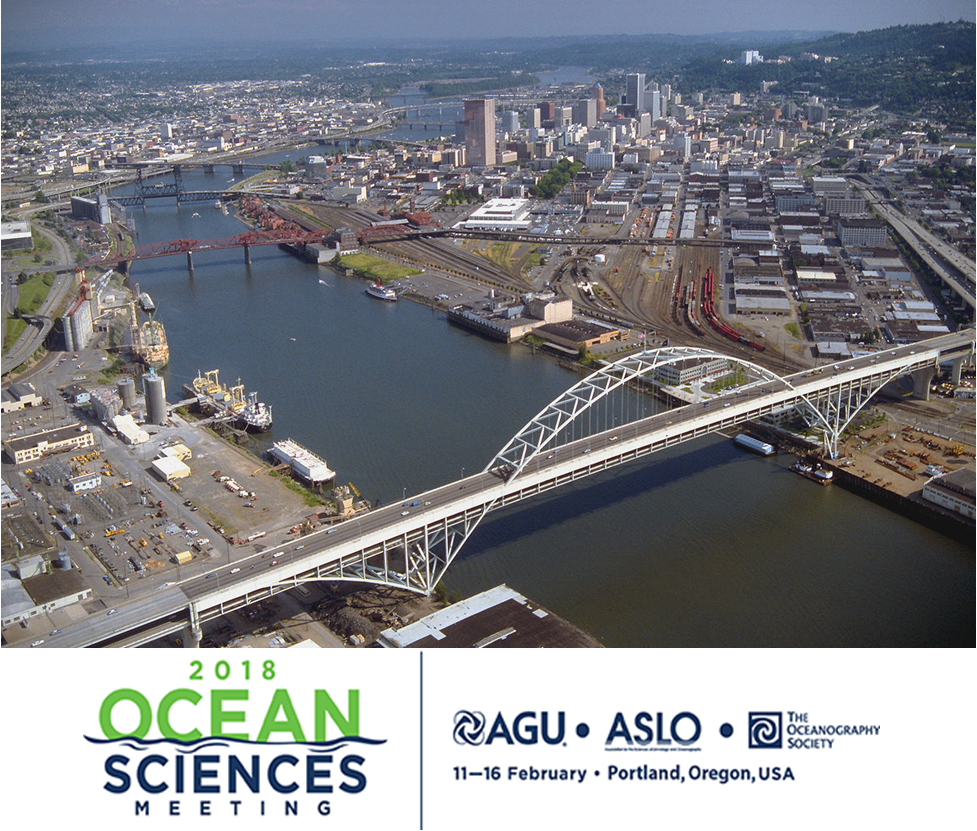
Image of the Willamette River in Portland, OR where the Ocean Sciences Meeting will take place.
More than 50 PMEL scientists, including scientists from NOAA, University of Washington's Joint Institute for the Study of the Ocean and Atmosphere (JISAO), Oregon State University's Cooperative Institute for Marine Resources Studies (CIMRS) and the National Research Council, will present a talk or share a poster on their research at the 2018 Ocean Sciences Meeting in Portland, Oregon February 12-16, 2018. PMEL research groups that will be present at the conference are: Acoustics, Arctic, Earth-Ocean Interactions, EcoFOCI, Engineering, Global Tropical Moored Buoy Array, Innovative Technology for Arctic Exploration, Large Scale Ocean Physics, Ocean Carbon, Ocean Climate Stations, Pacific Western Boundary Currents, Science Data Integration Group, Thermal Modeling and Analysis Project
28 talks will present research on ocean carbon, ocean acidification, ocean observing systems, Arctic research including the Distributed Biological Observatory and Arctic Marine Pulses (AMP), ENSO, MJO, hydrothermal vents, Saildrone research, air-sea interactions, SOCCOM, and ocean mixing. 26 posters will be up during the poster sessions and highlight research in the Arctic, hydrothermal vents, acoustics, methane bubbles and hydrates, Saildrone, Oculus Coastal Glider, ocean carbon, deep ocean temperatures, glider research in the Solomon Sea, and ocean acidification and hypoxia.
PMEL staff will also be chairing sessions and workshops on:
- El Nino-Southern Oscillation (ENSO) Diversity, Predictability, and Impacts
- Western Pacific and Indonesian Sea Circulation and Its Environmental and Climatic Impacts
- New Platform and Sensor Technologies: Advancing Research, Readiness, and Transitioning for Sustained Ocean Observing of Essential Ocean Variables
- Methane from the Subsurface Through the Bio-, Hydro-, and Atmosphere: Advances in Natural Hydrate Systems and Methane Seeps in Marine Ecosystems
- Cascadia Margin methane seep and hydrates to share results and coordinate future work
The 2018 Ocean Sciences Meeting is co-sponsored by the American Geophysical Union (AGU), the Association for the Sciences of Limnology and Oceanography (ASLO), and The Oceanography Society (TOS). The meeting is an important venue for scientific exchange across broad marine science disciplines. Sessions will include all aspects of oceanography, especially multidisciplinary topics, as well as presentations that reflect new and emerging research on the global ocean and society, including science education, outreach, and public policy

US Navy steam frigate USS Wabash, shown under steam and sail, lithograph based on painting by William N. Maull. Published by Shearman and Hart, 1865-67. During the Civil War, Wabash served as the flagship to Atlantic Blockading Squadron then the South Atlantic Blockading Squadron. Courtesy of the Library of Congress.
On Wednesday, January 4, 2018, the Council on Library and Information Resources (CLIR) and the Andrew W. Mellon Foundation publicly announced that 14 projects have been selected for the 2017 Digitizing Hidden Special Collections and Archives awards. One of the funded projects, Seas of Knowledge: Digitization and Retrospective Analysis of the Historical Logbooks of the United States Navy, is led by Kevin Wood, research scientist with the University of Washington Joint Institute for the Study of the Atmosphere and Ocean and NOAA PMEL. This new grant will allow these scientists to learn more about past climate from the records of long-gone mariners. The project will digitize the logbooks, muster rolls and related materials from U.S. naval vessels, focusing on the period from 1861 to 1879. Access to historical data is essential for understanding both past and current events, especially in the ocean domain where important geospatial, environmental, and social/cultural data are found only in manuscript formats inaccessible to computers.
After making digital images of the logbooks housed at the National Archives, the project will recover ships’ positions, weather records, oceanographic data and other historical information through the Old Weather citizen-science program that trains volunteers to transcribe the logs’ handwritten entries. So far volunteers have transcribed more than 3 million new-to-science weather records, and more than 1 million of those have been quality-checked and added into global climate databases. This historic weather and climate data helps scientists better understand modern climate change patterns and improve prediction. The new effort seeks to fill a gap in the data of past weather and ocean conditions.
The project will also digitize the National Archives’ related collection of muster rolls that shows the names of all the enlisted sailors on board. When combined with logbooks that list the names of officers, this will provide historians and family researchers an online database of unprecedented detail and a window into day-to-day life during this period in history, Wood said. The grant also will support an educational effort that will allow the public to explore the information uncovered in the ships’ logbooks through an interactive exhibit.
Other investigators on the project are Mark Mollan at the National Archives and Records Administration, Patrick Madden at the National Archives Foundation and, Gilbert Compo at the Cooperative Institute for Research in Environmental Studies at the University of Colorado and NOAA’s Earth System Research Laboratory.
This is the third group of projects to win a Digitizing Hidden Special Collections and Archives award, which is supported by The Andrew W. Mellon Foundation. The program supports the creation of digital representations of unique content of high scholarly significance that will be discoverable and usable as elements of a coherent, national collection.
Read the full story here written by Hannah Hickey, science writer for the University of Washington, on the latest development in the Old Weather project.
The 2017 Arctic Report Card was released today, December 12, at the American Geophysical Union’s Fall Meeting. The NOAA-led Arctic Report Card, now in its 12th year, delivers the latest in peer-reviewed, actionable environmental information on this important region, which is warming at twice the rate of anywhere on Earth. PMEL’s Dr. James Overland is one of four editors of the report card which brings together the work of 85 scientists from 12 countries to provide the latest information on multiple measures of Arctic environmental change such as sea ice, temperature, and permafrost.
In 2017, average annual air temperature was the second highest on record after 2016 with a temperature of 2.9 degrees Fahrenheit (1.6 Celsius) above the average for 1981 to 2010. While 2017 saw fewer records shattered than in 2016, the Arctic shows no sign of returning to the reliably frozen region it was decades ago. The current observed rate of sea ice decline and warming temperatures are higher than at any other time in the last 1,500 years, and likely longer than that. This year’s maximum winter sea ice area, measured each March, was the lowest ever observed, while this year’s minimum area, measured each September, was eighth-lowest on record. Sea ice is also getting thinner each year, with year-old ice comprising 79 percent of coverage, and multi-year ice just 21 percent compared to 45 percent in 1985.
You can watch the recorded press conference here which was led by RDML Tim Gallaudet, Ph.D., USN Ret. Assistant Secretary of Commerce for Oceans and Atmosphere and Acting Under Secretary of Commerce for Oceans and Atmosphere.
Read the NOAA Press Release here and the complete 2017 Arctic Report Card here.
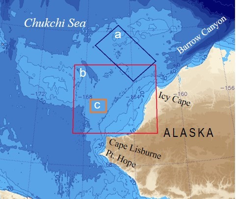
Study area and reference zones for freeze onset (a), Sea Surface Temperature (SST) (b), and ALAMO deployment area (c). AXBT and radiometer SST data were collected over the region between Bering Strait and the northern shelf break. Reference area (a) was selected because of the availability of oceanographic moorings and ship-based CTD data along the PMEL Icy Cape and Distributed Biological Observatory lines that will be available for data validation and other future research.
PMEL is initiating an experimental sea ice fall freeze-up outlook for northern Alaskan waters. The 2017 freeze onset on the Chukchi Sea continental shelf northwest of Icy Cape will begin near the end of November to the first week of December. This is approximately 36 days later than the long-term observed mean (1981-2016).
PMEL researchers with the Arctic Heat Open Science Experiment Based used observations from Air-Launched Autonomous Micro-Observer (ALAMO) floats, deployed in the summers of 2016 and 2017, Airborne EXpendable BathyThermograph (AXBT) arrays deployed in the region that measure ocean temperature as a function of depth from aircraft, and satellite data to project when sea ice freeze up will occur in the Chukchi Sea in 2017.
Float data reveal in real time the presence of ocean heat not detectable by satellite, and provide continuous monitoring of transport, water column stability, and cooling rate. This information is not otherwise available from other observing systems.
Read more about the rationale and data used here. For more information and data, visit the Arctic Heat website: https://www.pmel.noaa.gov/arctic-heat/.
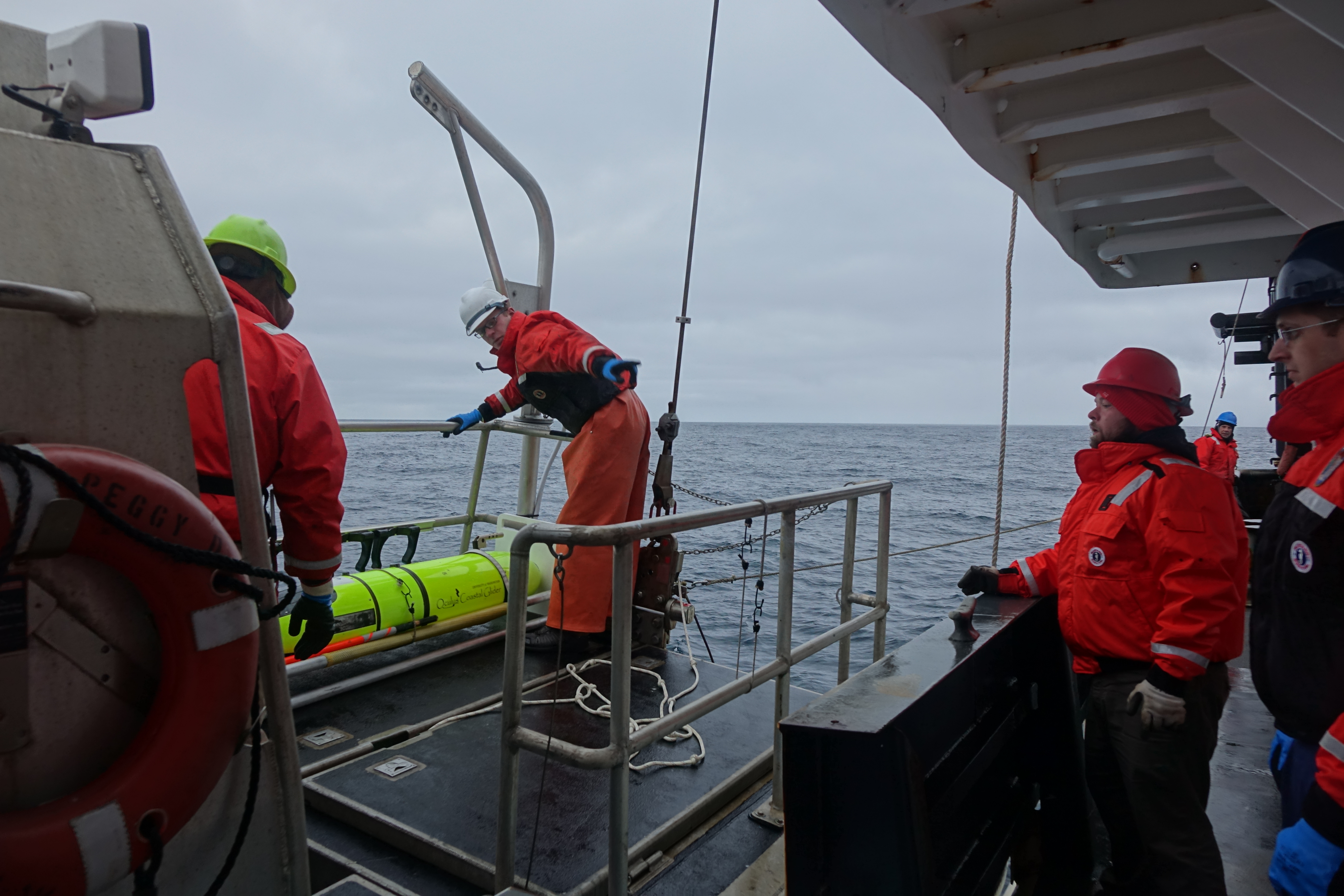
Oculus Coastal Glider being recovered by the crew of the NOAA Ship Oscar Dyson.
After 60 days in the Bering Sea, the Oculus Coastal Glider was successfully recovered by crew of the NOAA Ship Oscar Dyson on September 26, 2017. The glider successfully navigated 242.8 nautical miles, completed 3612 dives, and sampled salinity, temperature, dissolved oxygen, sunlight, and fluorescence at a frequency of approximately 3 dives per hour. The glider was tested in a region with a long history of shipboard and mooring observations that provide context for the Oculus glider's observations. Oculus glider measurements reveal detailed information in a known, important biogeographical transition that divides the ecosystems of the northern and southern Bering Sea shelf near St. Matthew Island. Measurements show unexpected ocean mixing in the water column near the island that may be due to internal waves. Data, sensor, and platform analysis is ongoing. Incorporating this higher resolution sampling into the Bering Sea observing network will improve our understanding of how these features affect the ecosystem.
The Oculus is a coastal glider engineered to work in the highly stratified, shallow depths of the Arctic. By using a rapid buoyancy system, the glider can change buoyancy states 20 times faster and achieve speeds three times faster than legacy gliders - allowing for a more efficient and adaptive Arctic survey, but transferable to a variety of markets.
This was the second field test for the Oculus coastal gliders. The first field test occurred early May 2017, also in the Bering Sea, with 387 dives completed near the M2 mooring site. For the second field test, the glider was deployed from the US Coast Gaurd Cutter Healy during the 2017 Arctic Shield mission.
The Oculus was developed at PMEL in partnership with the University of Washington's Joint Institute for the Study of the Atmosphere and Ocean and the University of Washington Seaglider Fabrication Lab.
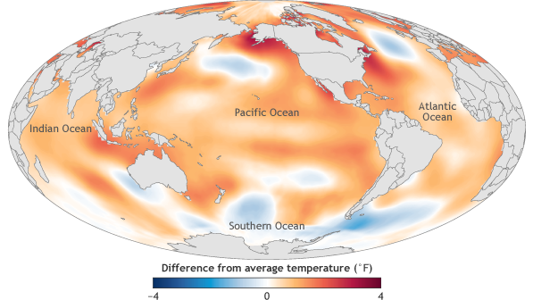
The image is of ocean surface temperature in 2016 compared to the 1981-2010 average. Despite the weakening 2015/16 El Niño event in 2016, the global average sea surface temperature in 2016 beat 2015 as the warmest year on record by a narrow margin. Image credit: NOAA Climate.gov map, adapted from Figure 3.1a in State of the Climate in 2016.
On August 10th, the State of the Climate in 2016 was published in a special edition of the Bulletin of the American Meteorological Society. This 27th annual report is based on contributions from more than 500 scientists representing over 60 countries around the world. It is the most comprehensive annual summary of Earth’s climate and provides a detailed update on global climate indicators, notable weather events and other data collected from locations on land, water, ice, and in space.
PMEL, including JISAO and JIMAR, scientists contributed to sections on the global ocean carbon cycle, ocean heat content and arctic air temperature.
The new report confirmed that 2016 surpassed 2015 as the warmest year in 137 years of recordkeeping. Several climate indicators also set new records in 2016, including greenhouse gas concentrations, sea level, and sea surface temperature. The Arctic also continued to warm with average Arctic land surface temperature 3.6°F (2.0°C) above the 1981-2010 average and sea ice extent and thickness remained low.
Dr. Gregory C. Johnson, PMEL oceanographer and editor for the ocean chapter, sums up in Haiku form:
Large El Niño wanes,
east Pacific tropics cool,
seas shed heat, slow rise
Read the full report, press release and report highlights.
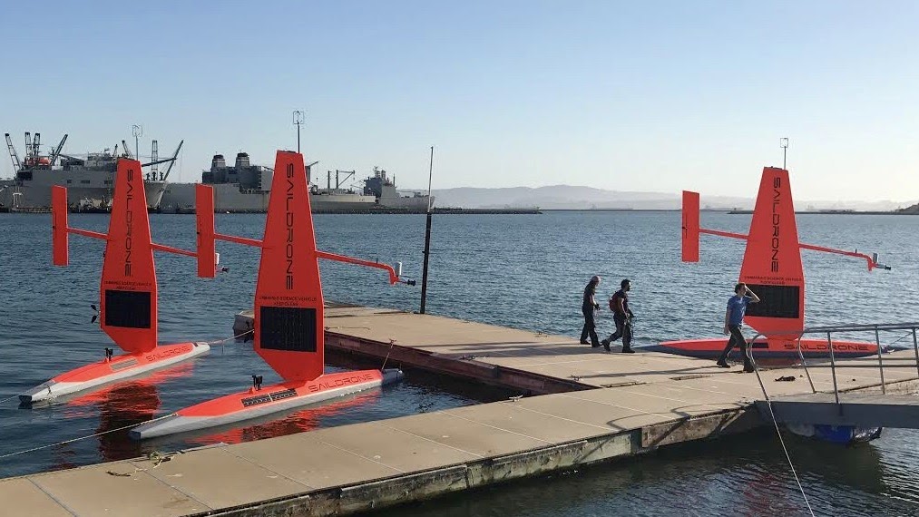
The fleet of saildrones pictured here are being prepared for a summer and fall of science from the Bering Sea to the Arctic to the far reaches of the tropical Pacific Ocean. Credit: Saildrone Inc.
Over the next four months, NOAA scientists will launch unmanned ocean vehicles, called Saildrones, from the Arctic to the tropical Pacific Ocean to help better understand how changes in the ocean are affecting weather, climate, fisheries and marine mammals. The wind and solar-powered research vehicles that resemble a sailboat will travel thousands of miles across the ocean, reaching some areas never before surveyed with such specialized technology.
Earlier this week, PMEL scientists and Saildrone, Inc. sent off three saildrones from Dutch Harbor, Alaska. For the first time, two saildrones will sail north through the Bering Strait into the Arctic Ocean to study how the Arctic Ocean is absorbing carbon dioxide. A third unmanned vehicle will survey more than 3,100 nautical miles in the Bering Sea for walleye pollock, Northern fur seals that prey on them and the elusive North Pacific right whale. This work will build on research conducted during 2016, including a study of fur seal feeding rates. NOAA Fisheries Alaska Fisheries Science Center scientists will also attach video cameras to fur seals to record feeding and verify the species and sizes of fish that fur seals are eating.
In September, scientists will launch two more unmanned systems from Alameda, Calif., on a six-month, 8,000-nautical-mile, round-trip mission to the equator to improve the Tropical Pacific Observing System (TPOS). TPOS provides real-time data used by the U.S. and partner nations to forecast weather and climate, including El Nino. The unmanned sailing vehicles will take part in a larger field study with NASA, and visit mooring sites along the array of observing buoys.
Read the release on NOAA Research here and follow along with the Innovative Technology for Arctic Exploration's Blog for the Bering and Chukchi Seas missions.
May 16-June 2: The second summer field season for the Arctic Heat Open Science Experiment began with its first flight out of Kotzebue, Alaska. The research team, including Kevin Wood, are flying aboard a specially-outfitted NOAA Twin Otter aircraft to launch traditional atmospheric and oceanographic probes as well as the experimental Air-Launched Autonomous Micro-Observer (ALAMO) floats into the Chukchi Sea. After last year's field missions, two ALAMO floats made it through the winter and are currently profiling every 5 days. Check out the raw data for float 9085 and float 9076.
Arctic Heat is an open science experiment, publishing data generated by the project to further NOAA Science Missions with real-time data to facilitate timely observations for use in weather and sea-ice forecasts, to make data readily accessible for model and reanalysis assimilation, and to support ongoing research activities across disciplines.
Arctic Heat is a joint effort of NOAA Pacific Marine Environmental Laboratory (PMEL) Arctic Research, the Innovative Technology for Arctic Exploration (ITAE) program, the ALAMO development group at the Woods Hole Oceanographic Institution (WHOI), and the Joint Institute for the Study of the Atmosphere and Ocean (JISAO) at the University of Washington.
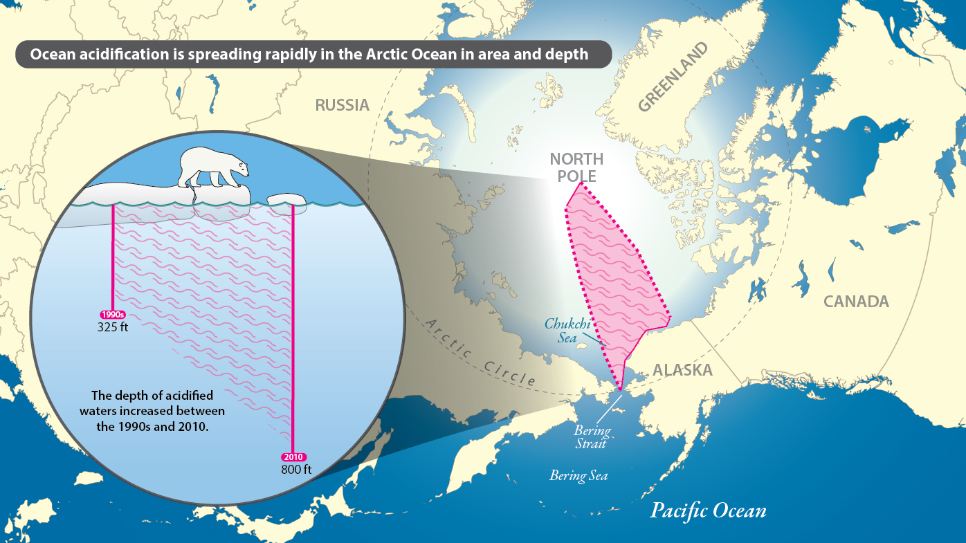
This map shows the extent of the research cruises conducted from 1994-2010 along with the spread of ocean acidification into deeper waters. Graphic Credit: Tammy Beeson/University of Delaware
New research published today in Nature Climate Change shows that ocean acidification is spreading rapidly in the western Arctic Ocean in both area and depth, potentially harming shellfish, other marine species in the food web and people who depend on these resources.
This research shows that between 1994 and 2010, acidified waters expanded northward approximately 300 nautical miles from the Chukchi Sea slope off the coast of northwestern Alaska to just below the North Pole. Also, the depth of acidified waters increased from approximately 325 feet to over 800 feet (or from 100 to 250 meters). The international research team determined the saturation state for aragonite, a carbonate mineral that marine organisms need to build shells, from water samples taken in the Arctic during cruises by the Chinese ice breaker XueLong (meaning “snow dragon”) in the summers 2008 and 2010, and during three other cruises. This research results showed that the Arctic Ocean is undergoing a rapid and large-scale increase in acidification, at least twice as fast as that observed in the Pacific or Atlantic oceans.
NOAA PMEL’s Richard Feely is a co-author on the paper led by China’s Key Laboratory of Global Change and Marine-Atmospheric Chemistry of State Ocean Administration, Xiamen, China, and the University of Delaware.
Read more on NOAA.gov and the University of Delaware's Press Release here. Learn more about PMEL’s Carbon Program on their website here.
Read the paper in Nature Climate Change here.
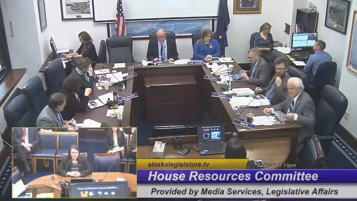
Jessica Cross (bottom left) giving her presentation to the House Resources Committee.
On February 22, 2017, Dr. Jessica Cross gave an invited presentation on ocean acidification and its potential impacts to fisheries and natural resources in Alaska to the Alaska State Legislature’s House Resources Committee. Dr. Cross was invited by Rep. Geran Tarr, Co-Chair of the House Resources Committee. The presentation covered impacts on food security and risk assessment for Alaska's fishery sector. Future projections of OA indicate imminent impacts on the Bristol Bay Red King Crab fishery, according to NOAA researchers in OAR and NMFS at the Alaska Fisheries Science Center. While in Juneau, Jessica also gave a talk to the University of Alaska, and the United Fishermen of Alaska (UFA). The Alaska Ocean Acidification Network facilitated these discussions as a way of connecting scientists like Dr. Cross to stakeholders, like UFA, and regulators at the state legislature. The Network brings together these diverse groups to identify knowledge gaps and information needs for future research and community resilience.
Dr. Cross' current research focuses on carbon biogeochemistry and ocean acidification in Arctic regions, especially along the Alaskan coast. Learn more about her work with the Innovative Technology for Arctic Exploration Group here.