Follow the Saildrone 2017
December - Closing Out
Mission Days: 76, Nautical Miles Covered: 7509.4 nm, Data Points Transmitted: 1.48 billion, Photos Transmitted: 3,184, Max Drone Speed: 10.82 ktMax Recorded Wind Speed: 41 kts, Best 24 Hour Run: 101 nm, Min Air Temp Recorded (F): 27.34, and Highest Latitude Reached: 75.03N
Oceanography, Fish, Fur Seals and Whales in the Bering Sea

Arctic Ocean Acidification Survey Survey

20 November - Dispatch from the Field: Update on Fur Seal Tagging
Carey Kuhn and her team are tackling the the big task of processing and analyzing the data. Head on over to the Alaska Fisheries Science Center's Dispatches From the Field to learn about the exciting science results the team are finding. You can also see several new videos. Carey and her team have been lucky to get to enjoy some time each day swimming under the surface of the Bering Sea checking out the world from a fur seals point of view!
Raw Video Footage:
• Watch as a northern fur seal makes a 3 minute dive to over 70 m in search of prey.
• A sneak attack from below catches a large walleye pollock off guard.
• In shallow water, a northern fur seal forages in a large school of small fish. How many do you think she caught?
05 October - Dispatch from the Field: Update on Fur Seal Tagging
Carey Kuhn and her team are back in Seattle and beginning to analyse the large quantity of data that was collected this year. This year's work is helping scientists, like Carey, gain a better understanding of the relationships between northern fur seals and the fish they depend on to survive. "The first video is about nine hours of recording over a period of a few days," says Kuhn. "Having all of these data together - the dive record, video during foraging events, and the echousounder is amazing."
Before she left St. Paul Island, they were able to recover three of six new cameras. The remaining fur seals didn’t return home in time to catch them. In the next few weeks, a team of scientists will head to St. Paul Island for a different northern fur seal project and they are going to try to catch the last few fur seals. "It’s not often we get a second chance to recover tracking instruments," says Kuhn. "So we are grateful they are willing to put in some extra work!"
This year, Carey and her team had the drones follow four of the fur seals that were equipped with cameras during their foraging trip. The video from the fur seals will be matched with the echosounder data (led by Alex De Robertis) to get a complete picture of what prey was available and what species of fish the fur seals were eating. "There’s a great deal of work ahead during the data analysis stage," says Kuhn. "There are hundreds of videos to review, so the data analysis will be a long process."
She still considers this field season a huge success, despite not getting everything done as planned. "It wouldn’t have been possible without the hard work of my field teams in both July and September," says Kuhn. "Their commitment, persistence, positive outlook, and humor, even during the unforeseen challenges and poor weather conditions, made it possible to collect an amazingly valuable dataset."
You can see more pictures, including a video on the original blog post at the Alaska Fisheries Science Center's Dispatches From the Field.
")
04 October - A Peek into Life on the Rookery - Puppy Pod
This video, captured in September, while C. Kuhn was tagging female fur seals at a rookery on St. Paul Island, gives a sneak peek into life on the rookery. Here, a 'puppy pod' of northern fur seal pups are playing together while adult females are foraging for fish or squid in the ocean. Take a peek!
Life on the Rookery. Video provided by C. Kuhn (NOAA Fisheries). Research conducted and photos collected under the authority of MMPA Permit No. 14327.
02 October - Photos from the Field
A few more photos of the recovery in Alaska. All went according to plan and we were very lucky with some beautiful weather. Photos provided by Saildrone Inc.


29 September - Home Sweet Home

On September 29, after three months of collecting data in the US Arctic, three sailing drones have safely returned to Dutch Harbor, AK.
The saildrones collectively traveled over 7775 nautical miles in under 90 days throughout the Bering and Chukchi Seas. After arriving in Dutch Harbor, AK, the drones will be packed into a container and shipped to their home base in San Francisco, CA. Data from the tested technologies for fish and marine mammal acoustics are expected mid-October with preliminary analysis completed in the New Year.
In mid-July, scientists sent off the unmanned sailing vehicles from Dutch Harbor, Alaska, with two sailing north through the Bering Strait into the Arctic Ocean and another transiting the Bering Sea. Traversing Alaska’s inhospitable waters, the remotely-operated vehicles tracked melting ice, measured the ocean's levels of carbon dioxide, and monitored for the presence of fish, seals, and whales to better understand their behavior and population.
One vehicle surveyed the Bering Sea for walleye pollock, Northern fur seals that prey on them and the elusive North Pacific right whale. This work will build on research conducted during 2016, including a study of fur seal feeding rates. Carey Kuhn, ecologist with NOAA Fisheries’ Alaska Fisheries Science Center, and her team also used, for the first time, video cameras on Northern fur seals to record feeding and verify the species and sizes of fish that fur seals are eating.
“Although we weren’t able to get everything done, I still consider this field season a huge success! It wouldn’t have been possible without the hard work of my field teams in both July and September,” says Kuhn. “There’s a great deal of work ahead during the data analysis stage of the project, but with help from my collaborators, this year’s work will help us gain a better understanding of the relationships between northern fur seals and the fish they depend on to survive.”
Also, for the first time, the vehicles journeyed through the Bering Strait into the Arctic with a newly adapted system to measure CO2 concentrations. "What a mission! The saildrones far exceeded our expectations, making it as far north as 75N, as close to the ice edge as 7 nm, and successfully transited Bering Strait both north and south, all firsts for unesc-orted, unmanned autonomous vehicles.,” says Jessica Cross, an oceanographer at NOAA Research’s Pacific Marine Environmental Laboratory.“Together with our colleagues, this data is going to help improve weather and climate forecasting and our understanding of ocean acidification in these critical ecosystem areas. We are extremely grateful to all our partners across Alaska and the scientific community for making this mission an outstanding success."
This was a collaborative mission led by NOAA including NOAA Research and NOAA Fisheries with partners Saildrone, Inc., Simrad AS/Kongsberg Maritime, Greeneridge Sciences, Inc, and Wildlife Computers.

19 September - Taking a break to share the science
This past week, members of Saildrone Inc., NOAA leadership, and researchers from PMEL visited Anchorage, AK for the annual Oceans conference held by the Marine Technology Society and IEEE Oceanic Engineering Society. Not only did Saildrone Inc. have a platform set-up in the Great Hall, but lots of PMEL saildrone science was being shared.

7 September - A Peek into Life on the Rookery
For the past week, Carey Kuhn, along with a team of four scientists from NOAA Fisheries, University of Alaska Fairbanks and Wildlife Computers, are on St. Paul Island for a second round of tagging Northern fur seals. However, this time, the team are using a state-of-the-art camera tag that records high-definition video, which will allow us to take a trip to sea from the point of view of a fur seal and record each time they feed.

Carey is using innovative customized video tracking tags to get a glimpse into the behavior of a Northern fur seal. With these tags, we’ll be able to see the fur seals trying to catch fish, confirm the species of fish, and estimate the age or size of the fish.

By linking the video data with the Saildrones echosounder data we can determine if feeding rates vary relative to the amount of fish that’s available. We’ll also be able to estimate foraging success based on the amount of effort a fur seal expends during each trip in relation to the amount of food consumed.

Using video cameras on marine mammals isn’t new but these are customized tags. They are significantly smaller than past video camera tags and have enough battery power to potentially record underwater activity during an entire foraging trip (3 to 5 days). We hope to have the first recordings back in the next few days!
30 August - Science at Sea | Checks and Balances
Calvin Mordy and Jessica Cross, both on the National Oceanic and Atmospheric Arctic Northern Chukchi Integrated Study research cruise aboard the United States Coast Guard (USCG) Cutter Healy, captured a rare at sea glimpse of actionable science they are conducting. It might be hard to imagine, but our principal investigators have not yet had the opportunity to see the saildrones in action. Everything is controlled remotely from Saildrone headquarters (Alameda, CA) and PMEL (Seattle, WA). It is one of the great advantages of the saildrone.
Yesterday, Jessica led an at-sea calibration exercise between the saildrones and the Healy. This is not the first time we have done a calibration; in fact, we often conduct them at the beginning and end of a mission with moored equipment and sometimes the NOAA fleet.
So what is a calibration? It’s a checks and balance system. Calibrations ensure accurate and quality measurements are being collected. This is of particular importance to scientists, especially when testing new platforms and technologies.

Our technology development program, Innovative Technology for Arctic Exploration (ITAE), works to add in new sensors to the saildrone every year. Sometimes these sensors are simple, but our team also works on a more complex ‘stretch goal’ sensor each year. Because these are more difficult design challenges, it’s very important to build calibration opportunities into the mission to check our work.
This year, the biggest ITAE challenge project was the adaptation of the Moored Autonomous pCO2 (MAPCO2) system. The MAPCO2 is a widely used industry standard for measuring surface ocean partial pressures of carbon dioxide (pCO2) and monitoring the intrusion of human-derived atmospheric CO2 into the oceans from stationary platforms. Our adaptation modified the MAPCO2 fast-moving mobile platforms like the Saildrone. We call the new version the Autonomous Sailing Vehicle CO2 (ASVCO2) system.

In the remote Bering Sea, where we have focused much of our saildrone work up until 2017, our opportunities for calibration are limited. At the start of this mission, we visited a MAPCO2 system located at the M2 time series site in the southern Bering Sea. This system has been monitoring the amount of CO2 levels and ocean acidification variables since 2013 with support from the State of Alaska, the North Pacific Research Board, the Alaska Ocean Observing System, and the NOAA Ocean Acidification Program. The system is maintained as a centerpiece of the Ocean Acidification Research Center at UAF and an important component of the Global Ocean Acidification Observing Network. During our comparison, the saildrones and the M2 mooring matched pretty closely. We earned a Weather Quality standard for data collection. This is excellent for our first true field deployment of the ASVCO2 system!
29 August - A Peek Ahead
The United States Coast Guard (USCG) Cutter Healy carries out scientific research in the vicinity of a saildrone. Today, our team will be conducting an at-sea calibration exercise in the southern Chukchi Sea between the saildrones and the Healy. The purpose of the rendezvous is for ITAE researchers, members of the science party aboard the USCG Healy, to calibrate specific instrumentation onboard the vehicles to that of samples taken on the Healy.

21 August - Dispatch from the Field: Update on the Fur Seals
The Saildrone is now 10 days into its survey of the northern fur seal foraging area and it’s covered more than half of its survey grid. The fur seals have completed between 2 and 5 foraging trips, heading out to sea for an average of just over 5.5 days per trip.
Similar to last year, there is a wide variation in the length of trips the females are taking and the distance and direction they are traveling from St. Paul Island. For example, one female is making trips that take only 4.5 days and she is usually feeding less than 200 km from St. Paul Island (pink lines). In contrast, another fur seal has only completed two trips so far because she is traveling on average over 300 km from the island, taking trips that last 8 to 10 days (green lines).

Our plan for this years’ Saildrone survey grid was to repeat the one conducted in 2016, which was based on a historical analysis of multiple years of fur seal tracking data. For 2016, the historical analysis successfully predicted the core area the fur seals would use and our preplanned grid was right on target. This year, the fur seals are using a larger foraging area. So we had to make last minute changes to the fur seal survey grid extending it to the north and east. The new grid plan now covers our target of 80% of the fur seals use area as of early August.
In one week Carey’s team will head back to St. Paul Island to start the video camera deployments. Six fur seals will carry the video cameras for a single foraging trip. This will give us the opportunity to see when the fur seals are feeding and to capture images of the fish they eat. Once the fur seals return from that trip, we’ll recapture the females and their pups to remove all of the tracking instruments. We’ll also weigh each animal to see how successful he or she was over the tracking period.
Read more of this blog post and follow the teams research in the field at NOAA Fisheries Alaska: Dispatches from the Field blogs, 'Northern fur seal food study in Bering Sea using Saildrone: Second year adding video'. You can also learn more about the 2016 field season, 'Understanding northern fur seal relationship with prey key to conservation'.
19 August - I Spy
Not too many days ago, we shared a young hitchiker on one of the Arctic sailing drones. Today we share two new camera captures!
A really nice photo (for our little camera) of an Arctic Tern at 71.56 N, -157.57 W.

And both the R/V Sikuliaq and a pinniped at ~71.38 N, -157.25 W. Based on the location, this may be a spotted or ringed seal. We are conferring with the pinniped experts at NOAA Fisheries to see if we can determine a specific species. We know this is the R/V Sikuliaq based on AIS, a way by which mariners can view nearby vessels using a display.

18 August - Here Fishy, Fishy
At present, the Bering Sea saildrone is surveying the fur seal grid and there are exciting conversations happening among the researchers. Alex De Robertis (fish survey) and Carey Kuhn (northern fur seal survey), have noted, that while very preliminary, they are seeing lots of near-bottom backscatter (image below) in the deeper areas of the shelf that are almost certainly from larger pollock, and that one of the seals seems to be keying into this. It's great to have the fish data coming in to see these associations in real time. Stay tuned for more updates including recovery of the video tags!

17 August - Let it Snow!
The big news this week comes from SD1002, who transited all the way out to 75 °N! Congratulations to our team that kept such a close eye on the saildrones. It certainly takes some effort: we rely on two different ice products, one from the National Snow and Ice Data Center (NSIDC, sponsored by NOAA, NASA, and NSF) and a custom product from the U.S. National Ice Center (NIC; sponsored by NOAA the U.S. Navy, and the US Coast Guard). Together, these products help show us a daily ice concentration and a 24-hour forecast for the 0% ice edge, but for more frequent data we also rely on the four cameras installed on the drone. Our team worked diligently to make sure all our instruments functioned well in the cold and monitored the cameras for ice. We never saw any ice (phew!) but we did get caught in a brief snowstorm!!

The cold and the snow appeared not to have any detrimental effects on instrument function, insofar as we can tell at this preliminary stage. Through the basin, xCO2 (SW) was mostly equilibrated with the atmosphere, except for a slight decrease at our closest point to the ice edge. This was our temperature minimum for the mission so far, with water very close to the freezing point (~-1.7 C). There wasn’t much else happening in the water column-- no big oxygen peak, no optics signals that indicate that this might have been a bloom, so it may be solely a temperature effect. We’ll have to look more closely at the data once we fully process it.
14 August - Spirit of 75

Late last week and into the weekend, SD1002 crossed over the shelf break in the Chukchi Sea and out into the Canada Basin, reaching 75 degrees north. To the best of our knowledge, this is as far north as anyone has ever sailed with an autonomous vehicle with no ship support.
Critically, SD1002 was able to capture ice melt in its very earliest stages, seeing salinities as low as 25. Compared to the shelf, which has a salinity of about 30-33, this is very low! Many ships don’t have the flexibility to access the ice melt region just as it forms, but this is one of the key advantages of working with a tactical platform like the Saildrone. We were able to zip right in as soon as the ice melted!
Support for our navigation around the ice edge comes from the National Snow and Ice Data Center (NSIDC for short). The researchers here specialize in remote sensing of Earth’s cryosphere, and they make the world’s best products that show sea ice position in the Arctic. One of the main products we use is called MASAM2: a hybrid product from the Multisensor Analyzed Sea Ice Extent (MASIE) and Advanced Microwave Scanning Radiometer 2 that shows ice concentrations on a 4 km grid. Here’s an animation of the recent MASAM-2 ice concentration product, with our latest Saildrone track overlaid:
You might notice that the MASAM2 product only measures as far down as 70% ice concentration. This means that even though the ice might be breaking up into smaller pieces from larger sheets, the satellite sees that about 70% of the 4 km pixel is covered with icy chunks. However, small ice chunks could still cause a big problem for the drone even when they are further apart. We also work closely with the US National Naval Ice Center special support team to look at even looser ice concentrations specifically for our navigational purposes.
The DRONE is now headed back south so that it will be over the shelf in time to meet USCGC Healy when it arrives for the Northern Chukchi Ecosystem Study. As more of the preliminary ice melt data is processed, we’ll keep you updated!

11 August - A young spotted seal hitches ride on sailing drone in the Arctic

One of our Chukchi drones had a hitchhiker this past week! A young spotted seal jumped on the back of a drone to haul out of the water much like it would to rest on an ice floe.
It’s not often that something other than the drone and water appear in our captured images while in the open ocean. In past years, we have seen gulls, a fishing boat, and even research boats. But, this past week we had our first marine mammal sighting.
Noticing that this small seal had hauled out on the drone, our team reached out to Michael Cameron (NOAA Fisheries) a research scientist studying ice seals with the Marine Mammal Laboratory’s Polar Ecosystems Program to share in the fun and confirm the species. “It does indeed look like a young spotted seal (Phoca largha),” said Cameron. “It is possible that it is a young-of-the-year seal (meaning it was born earlier this year in April), but it is difficult to tell scale from the photo and there is considerable uncertainty associated with field classification of age in young spotted seals.”
Most spotted seals in Alaska are born in April on the surface of sea ice floating in the Bering Sea. Their mothers nurse them on the ice for three to four weeks before weaning. As the sea ice continues to melt throughout the summer, spotted seals range more widely throughout the Bering and Chukchi Sea, like this seal.
Interestingly, having a young spotted seal on the stern of your sailing drone slows it down. “He's cute, and extra bonus: he didn't mess with the equilibrator tower too much!” said Jessica Cross, PI for the Chukchi mission. That equilibrator tower is what is helping Jessica monitor how the Arctic Ocean is absorbing carbon dioxide. And the seal kept inching closer and closer during it’s about six hour transit on August 4.
There was maybe one bad atmospheric CO2 data point during his ride with us,” said Cross. “But no other errors that I can see in the preliminary data.” His presence also counts as data. The young seal hitched a ride to some of the lowest CO2 measurements we have seen so far, possibly indicating a region with high productivity (and lots of food). During the time of the ride, it looks like we were sailing through some of the highest chlorophyll concentrations we'd seen so far. With the oxygen saturation levels at well above 120%, and significant CO2 drawdown, J.Cross thinks it's safe to say that we found a bloom. Interestingly, the CDOM concentration through this area were also fairly high (about equivalant to what we saw in the river water patch in the Bering Sea), which may idicate some terrestial organic matter presence coming out of the Sound. However, given the simultaneous productivty that produced the high oxygen levels, we didn't see the same respiration signal that we did in the Bering Sea.
We're also not the only ones who saw the high productivity signal. This year, thanks to support from both the NSF and NPRB Arctic Integrated Ecosystem Research Project, there are a number of cruises happening in the Chukchi Sea right now. Around the time that we did, the R/V Sikuliaq passed through the bloom with colleagues Burke Hales and Laurie Juranek. Laurie saw elevated oxygen levels through that same region, and Burke confirmed the extreme pCO2 drawdown. We’re all keeping in touch on Twitter... To follow along, look for us at @JessicaNCross, @laurie_juranek, and @Burke_O_Lator.

To learn more, a Status Review (2009) of the spotted seal is a great source of information on their life history and ecology.
10 August - Dispatch from the Field: Scientists capture images and other needed biological data on rare whales
Jessica Crance set sail for 60 days on board the Yushin Maru #2, as part of the Pacific Ocean Whale and Ecosystem Research (POWER) program, a collaborative effort spearheaded by the International Whaling Commission, to survey for whales and porpoises in the eastern Bering Sea. "My main goal is to locate animals from the eastern North Pacific population of the North Pacific right whale, arguably the most endangered large whale population in the world," said Crance. "With luck, the visual observers will be able to spot the animal, at which point we will attempt to photograph and obtain biopsy samples; these will provide crucial information on the current population status."
And they have! In just under two weeks into the two month survey, Jessica Crance not only heard the animals vocalizing but was able to capture photographs for animal identification and collect a biopsy sample from one of the two whales seen. In her blog, Jessica wrote "We hope that this is just the first of many encounters we have with these animals, as we still have yet to transit through their critical habitat. The information obtained from this survey will help us better understand the population dynamics of this critically endangered species, and help guide conservation and management efforts in the future."
This wonderful news comes at a time when the North Atlantic population is experiencing a devastating blow as an unprecedented number of whales have been found dead.
See images from Jessica's cruise at NOAA Fisheries Alaska: Dispatches from the Field blogs, 'Rare Opportunity to Study the Critically Endangered North Pacific right whale in the Bering Sea'.
Read more about the North Atlantic populations recent deaths at National Geographic News and Global News.
7 August - Gone with the wind: Sailing drones cross Bering Strait for the first time
In the early hours of August 1, two Saildrone vehicles, collecting data for NOAA, successfully sailed through the choppy waters of the Bering Strait after a 1600 km transit on their way into the Arctic.
“This was a real win. Bering Strait is a daunting place for even a small craft-- lots of traffic from much bigger ships, a fast current, and a confined area that pushes everyone close together,” says Jessica Cross, of NOAA Research’s Pacific Marine Environmental Laboratory (PMEL), who is using the unmanned system to study how the Arctic Ocean is absorbing carbon dioxide. “They handled the tough conditions without a hitch.”
The vehicles will now join NOAA’s Arctic Research Program 2017 Northern Chukchi Integrated Study. Here, they s will collect data as part of an observing network of ships and moorings. “Together, these diverse platforms will help give us an integrated picture of physical, chemical, and ecological conditions in the Arctic,” says Cross.
The Arctic region is currently undergoing large physical, chemical, and ecosystem changes, mostly caused by sea ice losses. Observing these changes is particularly difficult in a region with limited observational infrastructure.
Jeremy Mathis, director of NOAA’s Arctic Research Program, watched the crossing from his smart phone in Washington D.C. “This is a real game changer for NOAA’s ability to monitor the rapidly changing environment, says Mathis. “Even five years ago, we could not have imagined a vehicle with this capability and endurance. I believe it will become a workhorse of our sustained Arctic observing system.”
The 58 mile wide Bering Strait links the Bering and Chukchi Seas, forming the Pacific gateway to the Arctic Ocean. The boundary between the United States and Russia extends through this strait, splitting two small islands, Little Diomede (U.S.) and Big Diomede (Russia) only 2.5 miles apart at their closest point. The vehicles stayed well away from land on both sides of the strait, but both were able to see the distant outline of Little Diomede and Fairway Rock on the horizon. This will likely be the last land these drones see for some time.
Once north, one vehicle will collect a time series of data across the Distributed Biological Observatory zone 4, an important region of ongoing ecological change. USCGC Healy will visit this area later in the season to collect critical shipboard data.
The other drone will travel out into the Canada Basin, collecting CO2 data across a broad region. “This will be the furthest north an autonomous vehicle has ever operated without a ship-based escort,” says Cross. “It will dramatically expand the Northern Chukchi Integrated Study survey area.”
This Arctic mission is jointly supported by NOAA’s Innovative Technology for Arctic Exploration Program, Arctic Research Program, and the Ocean Acidification Program. These groups have been using a variety of autonomous platforms to survey the Bering Sea and the Arctic Ocean for the last three years, collecting an unprecedented amount of data that is expanding our understanding of Arctic seasonal processes and regional-scale ocean acidification.
NOAA’s PMEL began a partnership with Saildrone, Inc. in 2014 through a Cooperative Research and Development Agreement to develop unmanned surface vehicles that collect high quality oceanic and atmospheric observations. NOAA’s PMEL provides engineering expertise on sensors and sampling techniques and Saildrone, Inc. provides unmanned system hardware and software expertise.
Use of the Saildrone vehicles will help to fill important data gaps and expand NOAA’s observing conducted through traditional platforms. “This is a case of having the perfect tool at exactly the right time," says Mathis.
A shorter version of this story is posted on NOAA.gov as a Photo Story. You can find information on the launch of the saildrones at OAR.gov and a similar story at NOAA.gov. Follow NOAA Research on social media via Facebook (NOAA Office of Oceanic and Atmospheric Research), Twitter (@noaaresearch) and Instagram (noaaresearch).

VIsit NOAA.gov for more on this image.
28 July - Satellite tracking devices deployed and data are coming in
Carey Kuhn's field team is back in Seattle and the fur seals are off on their first foraging trip. It was a slow start but their last few days on St. Paul were very successful. They attached 16 tracking instruments to adult females and caught and weighed 15 of the females’ pups. This will give Carey and her team a starting point to measure pup growth over the season, which they hope to relate to the moms foraging success.
To help locate the pups when they return in September, each pup was given a unique haircut on its head. These marks will be visible until the pups go through their first molt in early September. The marks will help the researchers ensure they capture the correct mother-pup pairs when it comes time to recover the tracking instruments. Five of our fur seals have already completed their first foraging trips. In between foraging trips the female fur seals will spend 1 to 2 days on shore nursing their pup and resting. These periods on shore are an important time for the pups to get the milk they need to grow throughout the season. The mother-pup pairs will continue this cycle until the pups are approximately four months old.


27 July - Marine Mammal Acoustic Scientist Sets Sail
Jessica Crance set sail for 60 days on board the Yushin Maru #2, as part of the Pacific Ocean Whale and Ecosystem Research (POWER) program, a collaborative effort spearheaded by the International Whaling Commission, to survey for whales and porpoises in the eastern Bering Sea. "My main goal is to locate animals from the eastern North Pacific population of the North Pacific right whale, arguably the most endangered large whale population in the world," said Crance. "With luck, the visual observers will be able to spot the animal, at which point we will attempt to photograph and obtain biopsy samples; these will provide crucial information on the current population status."
Read more of this blog post and follow the teams research in the field at NOAA Fisheries Alaska: Dispatches from the Field blogs, 'Rare Opportunity to Study the Critically Endangered North Pacific right whale in the Bering Sea'.
21 July - The Journey Begins
Our journey begins in Dutch Harbor, Alaska. Two shipping containers arrived from San Francisco at a storage facility on the Aleutian island of Unalaska. They are unpacked, the equipment is assembled, and the sensors were turned on and then dry-tested. Once ready for launch, the assembled saildrones will began their three-month journey traversing the remote and inhospitable seas off Alaska. They will travel thousands of miles and reach areas never before surveyed with such specialized technology.
Richard Jenkins, owner of Saildrone Inc. whom NOAA partners with to conduct this research, is on site with his team. Like the innovative platforms he created, he will even control the drones from his iPhone here in Alaska and even when he returns to California after launch.
Almost two weeks delayed, the teams have modified their missions to adapt to the changing schedule. That we can abruptly change tactics like this and still be successful speaks to the saildrone's inherent flexibility and adaptability, one of the key reasons ITAE pursued this platform for development.
As they travel away, the three saildrone are a fluorescent beacon amidst the lush green mountains of Unalaska.
For the first time, the vehicles will journey through the Bering Strait into the Arctic with a newly adapted system to measure CO2 concentrations. They will start with comparison and calibration activities at the long-term mooring site M2, in the southeastern Bering Sea. Then it’s off to Bering Strait.
The third drone will survey more than 3,100 nautical miles in the Bering Sea alone in search of walleye pollock, Northern fur seals that prey on them and the elusive North Pacific right whale. This work builds on research conducted during 2016 in partnership with our neighbor here in Seattle - NOAA Fisheries Alaska.
We are all extremely excited for this years missions, and are patiently waiting for these larger faster saildrones to reach their main survey regions so we can start to answer questions about this highly productive and important (to all of us) ecosystem.


17 July - Dispatch from the Field: Northern Fur Seal Scientists arrive on St. Paul Island
Carey Kuhn and Jeremy Sterling have been on St. Paul Island for a couple of days and managed to get out seven tracking instruments on northern fur seals. Just like 2016, the work is being done on the northeast side of the island. By using the same tagging location, they will be able to compare years to look for a difference in both fur seal behavior and walleye pollock distribution.
"Over the next few days, we’ll finish deploying the fur seal tracking instruments and then head back to Seattle." said Kuhn. "Although the deployment process is a bit slower this year, I think we’ll be able to get out all 16 instruments before it’s time to leave."
Read more of this blog post and follow the teams research in the field at NOAA Fisheries Alaska: Dispatches from the Field blogs, 'Northern fur seal food study in Bering Sea using Saildrone: Second year adding video'. You can also learn more about the 2016 field season, 'Understanding northern fur seal relationship with prey key to conservation'.

St. Paul rookery. Photo: NOAA Fisheries
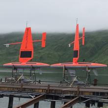
16 July - Launch!
We had a successful launch in Dutch Harbor, AK today. The three drones are currently making way to their respective survey locations.

15 July - Unpacking the Containers
The containers arrived in Dutch on Saturday, so R. Jenkins and D. Peacock (both of Saildrone Inc.) spent the day assembling the vehicles. They plan on launching the drones tomorrow. Stay tuned.

13 July - Dispatch from the Field - Marine Mammal Acoustics
Jessica Crance is a research biologist at Alaska Fisheries Science Center. She is back for a second year of marine mammal acoustics in search of the elusive North Pacific right whale. While the Saildrone project does not have a marine mammal acoustic field component, Jess had a unique opportunity to participate in International Whaling Commissions 8th Pacific Ocean Whale and Ecosystem Research (POWER) survey. Over the next few months, she will be part of an international team of scientists studying whales in the Bering Sea. Jessica will be listening for North Pacific right whales in particular and is hoping to locate one of the 30 or so remaining North Pacific right whales known to inhabit the eastern portion of the Bering Sea. If she does, she and others will photograph and collect small skin samples to learn more about these elusive and critically endangered creatures. Jess will be conducting her research on board a Japanese research vessel that was provided to the International Whaling Commission by the Government of Japan for the Commission’s survey. TWhat’s exciting is that this will be the first time that there will be an acoustic component to the research program. It also is the first time that there has been an opportunity to explore the expanse of the Bering Sea in search of North Pacific right whales. We are hoping for an opportunity to have our two surveys meet, to provide acoustic calibration of what sounds we may be hearing.
Follow her field research at NOAA Fisheries Alaska: Dispatches from the Field blogs, 'Rare Opportunity to Study the Critically Endangered North Pacific right whale in the Bering Sea'.
12 July - Dispatch from the Field - Northern Fur Seal Tagging
Carey Kuhn is an Ecologist at NOAA Fisheries Alaska. She is back for a second year of tracking northern fur seals on St. Paul Island and measuring prey availability in the northern fur seals feeding area. Follow her field research at NOAA Fisheries Alaska: Dispatches from the Field blogs, 'Northern fur seal food study in Bering Sea using Saildrone: Second year adding video' and 'Understanding northern fur seal relationship with prey key to conservation'.
This week Carey is headed to St. Paul to deploy the first round of dive recorders and satellite tags. The goal this year is to put tags on 16 females. Carey will post an update of her progress while on St. Paul . "Continuing this work is a fantastic opportunity that will help us build on what we learned in 2016", says Kuhn. "I’m looking forward to jumping back into the box and seeing how the fur seals are doing this year." Carey and her team will head to St. Paul again in early September, to deploy the new video cameras for a single foraging trip and to recover all of the tracking instruments.
.jpg")
11 July - Summer of sailing drones: Unmanned ocean vehicles are collecting data from the Arctic to the tropics
Over the next four months, NOAA scientists will launch unmanned ocean vehicles, called Saildrones, from the Arctic to the tropical Pacific Ocean to help better understand how changes in the ocean are affecting weather, climate, fisheries and marine mammals. The wind and solar-powered research vehicles that resemble a sailboat will travel thousands of miles across the ocean, reaching some areas never before surveyed with such specialized technology.
Probing Alaskan ocean waters
In mid-July, scientists will send off the first unmanned sailing vehicles from Dutch Harbor, Alaska, with two sailing north through the Bering Strait into the Arctic Ocean and another transiting the Bering Sea. Traversing Alaska’s inhospitable waters, the remotely-operated vehicles will track melting ice, measure the ocean's levels of carbon dioxide, and count fish, seals, and whales to better understand their behavior and population.
For the first time, the vehicles will journey through the Bering Strait into the Arctic with a newly adapted system to measure CO2 concentrations. “We want to understand how changes in the Arctic may affect large-scale climate and weather systems as well as ecosystems that support valuable fish stocks," says Jessica Cross, an oceanographer at NOAA Research’s Pacific Marine Environmental Laboratory (PMEL), who is using the unmanned system to study how the Arctic Ocean is absorbing carbon dioxide.
A third unmanned vehicle will survey more than 3,100 nautical miles in the Bering Sea for walleye pollock, Northern fur seals that prey on them and the elusive North Pacific right whale. This work will build on research conducted during 2016, including a study of fur seal feeding rates. Carey Kuhn, ecologist with NOAA Fisheries’ Alaska Fisheries Science Center, and her team will also attach video cameras on fur seals to record feeding and verify the species and sizes of fish that fur seals are eating. “We are excited to be able to use the video to see the ocean from a fur seal’s point of view,” says Kuhn. “Critical information about fur seals is still lacking and using the video camera and unmanned sailing vehicle will help us better understand this declining population.”
Surveying the tropical Pacific Ocean
In September, scientists will launch two more unmanned systems from Alameda, California, on a six-month, 8,000 nautical mile round trip mission to the equator and back to improve the Tropical Pacific Observing System (TPOS). TPOS provides real-time data used by the US and partner nations to forecast weather and climate, including El Nino. The unmanned sailing vehicles will take part in a larger field study with NASA, and visit mooring sites along the array of observing buoys. “Saildrones can do adaptive sampling like research ships, but at a fraction of the cost,” says Meghan Cronin, PMEL oceanographer. “We’ll be testing whether this new, enhanced tool can provide a suite of measurements at a quality that matches research ships and proven mooring technology. If this is the case, they may become a powerful tool to provide key observations for weather forecasts.”
NOAA’s PMEL began a partnership with Saildrone, Inc. in 2014 through a Cooperative Research and Development Agreement to develop unmanned surface vehicles that collect high quality oceanic and atmospheric observations. NOAA’s PMEL provides engineering expertise on sensors and sampling techniques and Saildrone, Inc. provides unmanned system hardware and software expertise.
“Drones will not replace other oceanic research systems,” says Cross. “Ships, buoys and satellites are still necessary, but these unmanned sailboats give researchers expansive views of the furthest corners of the world's oceans.”
You can find this story at OAR.gov and a similar story at NOAA.gov. Follow NOAA Research and NOAA Fisheries Alaska on social media via Facebook (NOAA Office of Oceanic and Atmospheric Research, NOAA Fisheries Alaska), Twitter (@noaaresearch, @noaafisheriesak) and Instagram (noaaresearch

01 June - 2017 Saildrone Missions Team
We are prepping for the 2017 missions. In the meantime, here are the 2017 missions team members.
NOAA Pacific Marine Environmental Lab ENGINEERING - CHRISTIAN MEINIG - NOAA/PMEL and NOAH LAWRENCE-SLAVAS - NOAA/PMEL RESEARCH SCIENTISTS OCEANOGRAPHY - Dr. CALVIN MORDY - JISAO/PMEL, Dr. JESSICA CROSS - NOAA/PMEL, Dr. PHYLLIS STABENO - NOAA/PMEL and Dr. NED COKELET - NOAA/PMEL FISHERIES ACOUSTICS - Dr. ALEX De ROBERTIS - NOAA/AFSC and Mike Levine - NOAA/AFSC WHALE ACOUSTICS - Dr. CATHERINE BERCHOK - NOAA/AFSC, JESSICA CRANCE - NOAA/AFSC and Dana Wright - NOAA/AFSC FUR SEAL TRACKING - Dr. CAREY KUHN - NOAA/AFSC and Dr. JEREMY STERLING - NOAA/AFSC NON-FEDERAL PARTNERS RICHARD JENKINS - SAILDRONE INC., IVAR WANGEN - SIMRAD AS/KONGSBERG and BILL BURGESS - GREENERIDGE SCIENCES, INC PROJECT COORDINATOR HEATHER TABISOLA - JISAO/PMEL MISSIONS MANAGER CDR TOM PELTZER - NOAA/PMEL/OMAO