2003/2006 Mariana Arc
Distribution of hydrothermally active volcanoes
Submarine volcanic arcs extend for fully a third of the length of the mid-ocean ridge system, but systematic investigation of hydrothermal venting on those arcs is sparse. In 2003 and 2004 we conducted an extensive exploration for hydrothermal activity along the intraoceanic Mariana arc. From these surveys we identify 76 volcanic edifices along 1370 km of arc, grouped into 60 ‘‘volcanic centers,’’ of which at least 26 (20 submarine) are hydrothermally or volcanically active. The overall volcanic center density is 4.4/100 km of arc, and that of active centers is 1.9/100 km. An equal length of the Tonga-Kermadec arc holds fewer centers, 2.9/100 km, but a similar density of active centers, 1.8/100 km. Active centers are found from 80 to 230 km above the subducting Pacific slab, and a quarter lie behind the arc front. The frequency distribution of center spacing along the arc front peaks between 20 and 30 km, and there is no evidence for a regular spacing of volcanic centers. Using the new Mariana data and recent data from the Tonga-Kermadec arc, we estimate that all intraoceanic arcs combined may contribute hydrothermal emissions equal to ~10% of that from the global mid-ocean ridge.
Baker, E. T., R. W. Embley, S. L. Walker, J. A. Resing, J. E. Lupton, K.-I. Nakamura, C. E. J. de Ronde, and G. J. Massoth (2008), Hydrothermal activity and volcano distribution along the Mariana arc, J. Geophys. Res., 113, B08S09, doi:10.1029/2007JB005423. (PDF)
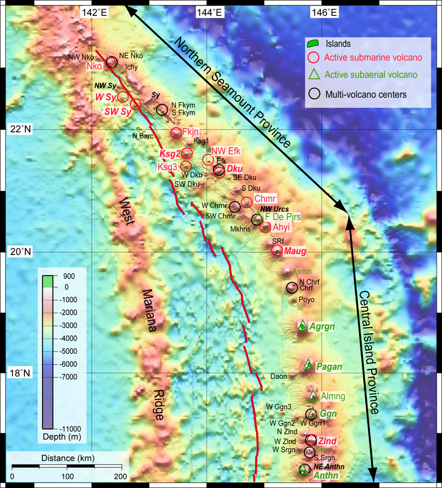 Northern/Central Mariana
Bathymetry of the northern and central Mariana arc region, showing all 51 edifices presently named along the volcanic front between 16°10’ and 23°10’N. Hydrothermally or volcanically active submarine edifices are labeled red; active subaerial edifices are labeled green. Inactive submarine and subaerial edifices are labeled in smaller black and green font, respectively. For all edifices, caldera labels are in bold italics. Black circles (20-km diameter) identify those volcanic centers composed of multiple individual edifices. Solid red line is the back-arc spreading center.
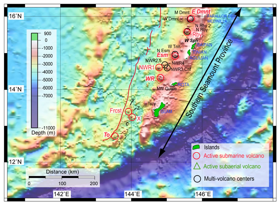 Southern Mariana
Bathymetry of the southern Mariana arc region, showing all 25 edifices presently named along the volcanic front between 12°30’ and 16°10’N, plus islands of the now inactive frontal arc ridge (blue capitals). Map labels are as northern Mariana arc figure. Question marks at the southern end of the arc identify possible arc volcanoes not yet mapped or studied.
Volcanic ash transport from NW Rota-1
NW Rota-1 is an active submarine volcano in the Mariana Arc with a summit depth of 517 m and an explosively erupting volcanic vent southwest of the summit at a depth of 530–560 m. During periods of ongoing explosive eruptions, particle plumes can surround the volcano. At least 3.3 x 10⁷ m3 of volcaniclastic material was deposited on the southern flank between 2003 and 2006. Particle plumes over the summit are magmatic-hydrothermal in origin characterized by 3He enrichment, hydrothermal precipitates, and low pH values. Plumes at multiple depths below the summit surround the volcano and are composed overwhelmingly of fresh, glassy shards of basalt. Rare anhydrite particles are present, indicating that the source of the deep plumes is at the eruptive vent, and that the downslope transport must be far faster than settling of individual particles. The deep plumes most likely originate from sediment gravity flows generated by explosive eruptions or slope failure and landslides of unstable materials that accumulate near the eruptive vent. These observations link mechanisms for the transport of volcanic ash in the submarine environment to the types of deposits common in volcaniclastic aprons and fine ash layers in distal sediments.
Walker, S. L., E. T. Baker, J. A. Resing, W. W. Chadwick Jr., G. T. Lebon, J. E. Lupton, and S. G. Merle (2008), Eruption-fed particle plumes and volcaniclastic deposits at a submarine volcano: NW Rota-1, Mariana Arc, J. Geophys. Res., 113, B08S11, doi:10.1029/2007JB005441. (PDF)
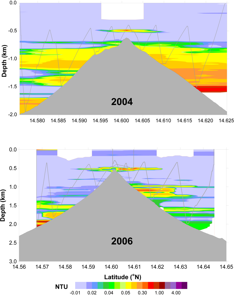
Examples of particle plume distributions at NW Rota-1 in 2004 and 2006. Light gray lines show the saw-toothed towpath of the CTD during tow-yos.