1996 Volcanic Activity on the Gorda Ridge
Beginning at 0700 GMT on 28 February 1996, intense seismicity was detected in the northeast Pacific Ocean using the T-phase Monitoring System developed by NOAA/PMEL to access the U.S. Navy's SOund SUrveillance System (SOSUS) in the northeast Pacific. The current event is located on the northernmost segment of the Gorda Ridge near 42 40'N and 126 48'W. The nature of the seismicity is very similar to that observed in June 1993 at the CoAxial Segment of the Juan de Fuca Ridge, which was later documented to be a lateral magma injection with subsequent eruption.
Scheduled cruises in the northeast Pacific
Quick Reference
DAILY UPDATESEVENT DETECTION
- Data Acquisition
- Seismicity
- Epicenters
PRE-EXISTING DATA
FIELD RESPONSE
- Initial Planning
- NOAA Ship McArthur Response
- R/V WECOMA Response
- NOAA Ship DISCOVERER Response
PRELIMINARY RESULTS
- Event Plume Temperature Cross-Section
- Event Plume Helium-3 Results
- Event Plume Particle Results
- Event Plume Dissolved Chemistry Results
- Seafloor Geology Results
RELATED SITES
EVENT DETECTION
Data Acquisition
Although the NOAA/PMEL data acquisition systems have recorded continuously during this event, there have been some problems with the Navy's SOSUS arrays that have led to discontinuous data. A quick response by maintenance personnel from NOPF Whidbey Island restored all relevant arrays by 3/6/96
Seismicity
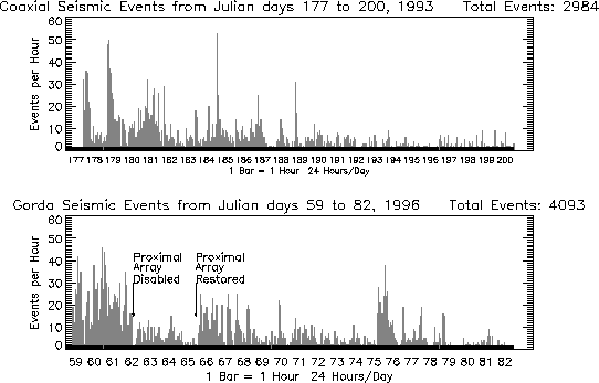
The general nature of the seismicity appears very similar to that observed from the CoAxial dike injection and eruption of June/July 1993. A rapid series of small earthquakes is observed without a large "foreshock". The following histogram displays the number of recorded events per hour. This level of activity is comparable to the level recorded from CoAxial segment in 1993. The apparent decline in activity midday on Julian Day 62 until late on Julian day 65 is likely due to the loss of the closest array. Data are grouped by days.
The following spectrograms compare this event to CoAxial event's onset. The time series on the left represents the output of an acoustic beam directed at the respective sites. The color spectrograms represent time in y (1-minute ticks) and frequency in x (0-75 Hz). Due to current security restrictions, the actual arrival times are not shown; however, the similarity in the character of the events is obvious.
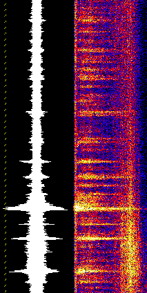
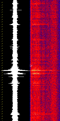
Gorda Ridge Event(Current) CoAxial Event(1993)
Epicenter Locations
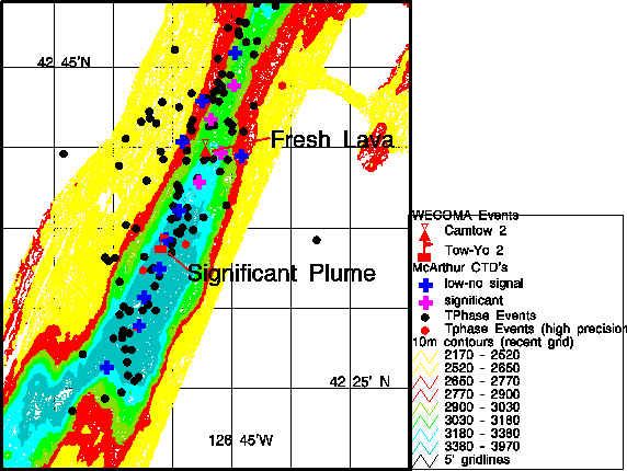
For the first 42 hours, no precise locations could be derived due to the outage of two well-located SOSUS arrays. SOSUS operators at Naval Ocean Processing Facility, Whidbey Island, Washington, were able to confirm the presence of seismicity in the general area of the northern Gorda Ridge based on distant arrays. The first good epicenters were collected during the 36-hour period 061-0100 --> 062-1240 and are shown in the accompanying graphic.The black dots represent t-wave epicenters. Red dots include additional arrays. Locations of CTD casts from NOAA Ship McArthur are plotted as crosses (blue for no detected plume; magenta for plume anomaly). Oceanographic profiles for each location are shown below. Location of seafloor lava flow and new plume discovered by WECOMA are marked in red.
Data through 2300Z 3/19/96
PRE-EXISTING DATA
Fortunately, substantial data sets have been previously collected in this area. Water column surveys collected by NOAA in 1985 and later surveys by Oregon State University showed water column temperature anomalies in the area, which was labeled GR-14. Full SeaBeam coverage has been collected by NOAA. SeaMARC II surveys were collected in the area in 1983 by USGS/UH. Detailed SeaMARC I surveys were collected by NOAA/PMEL in the northern half of the segment in 1987. Camera surveys were conducted in 1985-86 by USGS and NOAA/PMEL. Extensive dredges were also collected by USGS. The Navy's SeaCliff submersible dove in the area in 1988.
FIELD RESPONSE
Initial Planning
NOAA/PMEL is currently investigating the availability of NOAA ships for a field response effort. Water column measurements would be emphasized in any NOAA effort. A variety of expeditions are scheduled for the northeast Pacific this summer. Field response is being coordinated Jim Cowen (U. Hawaii), Bob Embley (NOAA), and Marv Lilley (U. Wash) through the RIDGE Program.
Update 3/4/96 1600 PST The NOAA Ship McArthur will sail from Seattle at 1500 PST on Thursday, March 7 to perform 2-4 days of water column surveys at the site. Ed Baker of PMEL will be Chief Scientist.
Update 3/6/96 1100 PST If the McArthur cruise reveals evidence of "event" type plumes present at the site, there will be strong interest for follow up efforts. One near- term possibility is an open slot in the schedule of the R/V WECOMA, the UNOLS vessel operated by Oregon State University. The WECOMA is presently scheduled to depart San Diego on 28 March and could be available until about 19 April if resources were available to pay for shiptime, etc.
NOAA SHIP McARTHUR Response
- 3/11/96 Report From Ed Baker on McArthur
R/V WECOMA Response
- Message from RIDGE Office on WECOMA Cruise (3/20/96)
- Cruise plan for WECOMA (4/3/96)
- WECOMA Field Response (4/6/96-4/16/96)
NOAA SHIP DISCOVERER Response
- 6/13/96 Report From Ed Baker on DISCOVERER
PRELIMINARY SCIENTIFIC RESULTS
RELATED RESEARCH AND WEB SITES