|
Report to GSOP | ||||
Tropical Moored Buoy Implementation Panel (TIP) Report
Michael J. McPhaden, TIP Chairman
Prepared for CLIVAR Global Synthesis and Observation Panel (GSOP)
1. Background
The Pilot Research Moored Array in the Tropical Atlantic (PIRATA) is a designed to provide high quality data in real-time for improved description, understanding, and forecasting of tropical Atlantic climate variability such as that associated with interhemispheric sea surface temperature (SST) gradients and Atlantic warm events analogous to Pacific El Niños (Servain et al, 1998). PIRATA is a joint effort between the U.S. (NOAA/PMEL), France (Institut de Recherche Scientifique pour le Développement on Coopération [IRD] and Météo-France), and Brazil (Instituto Nacional de Pesquisas Espaciais [INPE] and Diretoria de Hidrografia e Navegacao [DHN]). Like TAO/TRITON, it is considered an important component of GOOS and GCOS.
2. Status
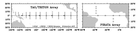
Daily mean surface meteorological measurements (wind speed and direction, air temperature, relative humidity and sea surface temperature) and subsurface temperatures are the primary data telemetered in real time from moorings of the TAO/TRITON array. NextGeneration ATLAS moorings provide high temporal resolution (10-min or less record interval) measurements in delayed mode and optional enhanced measurements, which include precipitation, short and long wave radiation, barometric pressure, salinity, and ocean currents. At present ATLAS moorings within the TAO/TRITON Array measure salinity and rainfall at 25 sites, short wave radiation at 11 sites, currents at 4 sites, and barometric pressure at 3 sites. TRITON moorings can measure all of the above parameters except longwave radiation. TAO/TRITON data return remains high, with overall data availability in real-time of 86% for the period 1 October 2003 to 30 September 2004. Damage to moorings and sensors from fishing activity continues to be a concern. This damage accounts for a significant amount of data loss, especially in the far eastern and far western portions of the Pacific basin. Some real-time data losses are due to telemetry problems. Data are also internally recorded; thus data return typically increases by a few percent after moorings are recovered. Plans in the near future call for instrumenting all ATLAS moorings to measure sea surface salinity (SSS). All TRITON moorings already measure SSS, so the combined array will provide basin scale high temporal resolution coverage of this parameter. The SSS data will be valuable for research purposes and for operational analyses and forecasts. They will also be valuable for validating salinity retrievals from the European Space Agency’s Soil Moisture and Ocean Salinity (SMOS) satellite scheduled for launch in 2007 and from NASA’s Aquarius satellite scheduled for launch in 2008. Additional near term plans call for upgrading 5 sites in TAO/TRITON to full surface flux measurement capability as a contribution to the OceanSITES program (http://www.oceansites.org). Plans for the Pacific Upwelling and Mixing Physics (PUMP) process study embedded in the TAO/TRITON along 140°W are also under development. Engineering redesign efforts are underway at PMEL to reduce costs, enhance reliability, and improve functionality of existing mooring technologies. Some upgrades to the present ATLAS system (e.g. Iridium telemetry, sonic anemometers) are in the testing and prototype development stage. JAMSTEC also plans to develop a smaller version of the TRITON mooring to enable deployments from smaller vessels than the RV Mirai. These newer style moorings would be deployed in the Indian Ocean and eventually be phased in to replace older TRITON moorings in the Pacific. Management of the TAO portion of TAO/TRITON was officially transferred from PMEL to NOAA’s National Data Buoy Center (NDBC) in October 2004. A gradual transfer of responsibilities is planned through 2007. Current TAO staff at PMEL will continue to provide operational support for the array throughout the transition. 2.2 PIRATA
The PIRATA mooring array at present consists of 10 PMEL ATLAS moorings (Fig. 1) which measure the same primary meteorological and oceanographic parameters as in TAO/TRITON, plus precipitation, shortwave radiation and salinity at 4 depths in the upper 120 m. The array also includes velocity measurements from a ADCP mooring at 0°, 23°E. These measurements began December 2001 and, though there is data gap between December 2002-February 2004, the site is now scheduled for continuous occupation with an ADCP mooring for the duration of the program. Following an initial “pilot phase” (1997-2001), PIRATA is nearing the end of a 5-year (2001-2005) “consolidation phase”, during which the array will undergo evaluation with regard to its utility for research and operational forecasting. The future of PIRATA will be the focus of PIRATA-10, to be held 14-16 December 2004 in Fortaleza Brazil. Discussions will include the impact that PIRATA data have had on our understanding of and ability to predict tropical Atlantic climate variability. Also on the agenda for discussion will be possible expansions of the array as part of the intensive 5-year (2006-2010) international Tropical Atlantic Climate Experiment (TACE) and as part of national and regional programs led by Brazilian and South African investigators. Likewise, consideration will be given to upgrading 3 existing PIRATA sites to full flux measurement capability in support of the OceanSITES program. 2.3 Indian Ocean
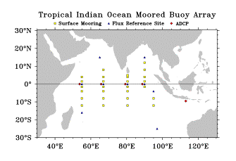
Figure 2. Proposed Indian Ocean Moored Buoy Array.
3. Data Management and Tracking TAO/TRITON and PIRATA data are widely disseminated via the Web and the GTS. The research community generally takes advantage of coordinated project Web sites maintained in the US, Japan, France, and Brazil for access to the data (see section 6.2). Data are also available from national archives and various global data assembly centers such as CORIOLIS in France and the GODAE server in Monterrey, California.
TRITON is currently updating its data processing and delivery system. By early 2005, data sets not presently available, such as salinity measurements and high-resolution (i.e. hourly) data, will be freely and openly distributed via the Web. Both the TAO and TRITON Project Offices are also developing Web Services capabilities that will allow automated machine-to-machine data delivery.
PMEL maintains several metrics on data usage such as files delivered via PMEL’s web pages (e.g., 167K between October 2003 and September 2004), refereed publications that rely on TAO/TRITON data (typically 30-50 per year), and TAO web page hits (typically 20-25M per year). NOAA’s Office of Climate Observations also tracks TAO/TRITON and PIRATA Array performance in the context of other observing system components.
At present, national and international CLIVAR basin panels provide scientific guidance for moored buoy programs that contribute to CLIVAR objectives. Implementation is coordinated through the CLIVAR/JCOMM Tropical Moored Buoy Implementation Panel (TIP). The TIP is also an action group of the Data Buoy Cooperation Panel (DBCP). The chairman of the TIP serves on the CLIVAR/GOOS Indian Ocean Panel, the CLIVAR Pacific Panel, and the Joint WMO/IOC Commission for Oceanography and Marine Meteorology (JCOMM) Observing Platform Support (JCOMMOPS) committee. Coordination is also carried out at a bilateral level between Japan and US in the case of TAO/TRITON and a trilateral level between France, Brazil and the US in the case of PIRATA.
5. Key issues for the future
Moored buoy arrays are but one component of GOOS and GCOS and need to be integrated with other observing system elements for the most comprehensive view of oceanic and atmospheric variability. Data assimilation efforts that produce consistent analyses are one method to synthesize information from disparate sources. Also, the sensitivity of analysis products to various data inputs can help to identify observational priorities across different observing system components. GSOP can provide guidance, through both expert opinion and data assimilation efforts, on measurement strategies that cut across the various subsystems.
5.3 Ship time Ships with specialized equipment, adequate deck space, and sufficient capacity to carry several moorings are required for recovery and deployment operations. Ship time at present is adequate for maintaining TAO/TRITON through dedicated NOAA and JAMSTEC cruises. In the Atlantic, ship time sufficient for servicing PIRATA buoys approximately once a year has been provided by France and Brazil, though there have been times (e.g. in 2005 for the eastern basin as described in section 2.2) when the necessary ship time has been extremely difficult to secure. Even so, once per year servicing of PIRATA buoys is not optimal and is reflected in lower data returns than in the Pacific where twice per year servicing is the norm. Ship time requirements to implement the Indian Ocean moored buoy array in Fig. 2 will be substantial (several months per year). Identification of appropriate ships and coordination of ship schedules will be a major challenge in the development of the array. These ship time issues are best dealt with by the program operators in concert with national funding sources. However, once a stable base of ship time is identified, it can be further exploited in the development of other observing system components, such as for drifter and float deployments. 5.4 Vandalism Fishing-related activities are a major cause of data and equipment loss for TAO/TRITON and PIRATA. These activities involve vandalism of moored buoys by tropical tuna fishing fleets and gear conflict between mooring and fishing equipment. Traditionally, the regions hardest hit in Pacific are the far eastern and western margins of the array that are close to land. As a result, the four Pacific TRITON moorings at 130°E and 137°E that are not formally part of TAO/TRITON (Fig. 1) are not equipped with meteorological sensors. The upwelling zone in Gulf of Guinea experiences the greatest losses in the Atlantic. Vandalism there forced PIRATA to decommission two sites at 2°N and 2°S along 10°W in 2000, thus reducing the size of the array from the original 12 sites to the present 10. TRITON moorings and moorings of the Indian National Data Buoy Program in the Indian Ocean have experienced similar problems with fishing vandalism. To mitigate equipment loss, the meteorological sensor package on the TRITON mooring at 5°S, 95°E has been downgraded recently to include only an anemometer and air temperature/humidity sensor. The TAO and TRITON Project Offices have for many years attempted to educate and inform the fishing community about the negative consequences of these losses for research and for weather, climate, and ocean forecasting. Likewise, engineering design strategies to discourage vandalism and mitigate its effects have been implemented. However, these efforts have met with only limited success. Planning for development of a basin scale Indian Ocean moored array should therefore factor in a percentage of loss in developing equipment inventories and likewise strive for a semi-annual servicing schedule so as to minimize the impact of these losses on data return.
As discussed in Section 2.1, NOAA/NDBC took over management responsibility for TAO array in October 2004. Within NOAA, there is no precedent for successful transition from research to operations of an ocean observing system for climate. It will be important to monitor the progress of this transition because CLIVAR must ensure that the array continues to meet its scientific requirements and because this transition will set the standard for future planned transitions in the US such as for Argo.
6.1
References
Masumoto, Y., V.S.N. Murty, M. Jury, M. J. McPhaden, P. Hacker, J. Vialard, R. Molcard and G. Meyers (2002) Tropical Indian Ocean mooring array: Present status and future plans. Reports of the First Conference of the Indian Ocean Global Ocean Observing System, November 2002, Grand Baie, Mauritius (http://www.incois.gov.in/Incois/iogoos/documents.jsp).
McPhaden, M.J., T. Delcroix, K. Hanawa, Y. Kuroda, G. Meyers, J. Picaut, and M. Swenson, 2001: The El Niño/Southern Oscillation (ENSO) Observing System. In: Observing the Ocean in the 21st Century. Australian Bureau of Meteorology, Melbourne, Australia, 231-246.
Servain, J., A.J. Busalacchi, M.J. McPhaden, A.D. Moura, G. Reverdin, M. Vianna, and S.E. Zebiak, 1998: A Pilot Research Moored Array in the Tropical Atlantic (PIRATA). Bull. Am. Meteorol. Soc., 79, 2019-2031.
6.2
Web addresses
TAO/TRITON http://www.jamstec.go.jp/jamstec/TRITON/
PIRATA http://www.pmel.noaa.gov/pirata/ http://www.brest.ird.fr/pirata/piratafr.html http://satelite.cptec.inpe.br/imagens/dadospcd/pirata/
|
| Home | Project overview | Data display | Data delivery | El Niño & La Niña | Site map |
|
TAO
Project Office |