| Research Overview | |||
|
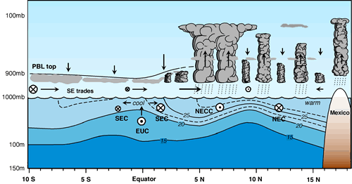
INTRODUCTION The principal goal of the PACS program is to extend the scope and improve the skill of operational Pan-American seasonal-to-interannual climate prediction, and, in particular, to improve warm season rainfall prediction over the Americas. Improved predictability will depend crucially on improving our understanding of the oceanic boundary forcing, and in particular, the relationship between the surface heating gradient and the sea surface temperature (SST). The eastern tropical Pacific near the Pan-American land masses is characterized by southerly winds and a stratus deck which extends from the cool waters off South America to the convective region of the cold tongue (CT) / intertropical convergence zone (ITCZ) complex. Beneath the stratus and particularly near the equator, SSTs are cool, while at and north of the ITCZ, in the "breeding grounds" of east Pacific tropical storms, SSTs are extremely warm (Fig. 1).
Anomalous SSTs in the eastern tropical Pacific have the ability to perturb the atmosphere and alter weather and climate both locally and remotely. On interannual time scales, SST anomalies associated with El Nino cause, and in turn are caused by, shifts in the basin-scale convection and wind patterns. On seasonal time scales, the cold tongue formation is associated with a meridional migration of the ITCZ and intensified southerly winds on the equator in the far eastern Pacific. On tropical instability time scales, variations in the SST are reflected in wind stress fields, apparently due to the influence of SST on the stability of the atmospheric boundary layer. On diurnal time scales, SST variations potentially have the ability to cause late afternoon cloud formation. Understanding the ocean-atmosphere coupling responsible for the structure and evolution of the large-scale heating gradients and wind and rainfall patterns in the CT/ITZC complex is a prime objective of the Eastern Pacific Investigation of Climate processes (EPIC) program, a 5-year process study initiated by PACS. PROJECT GOALS
Our goals are to: * Obtain near-realtime daily averages of all enhanced TAO data and make available to data center and the modeling community from PMEL-maintained ftp and websites. All standard TAO measurements from the new sites along 95°W (3.5°N, 10°N, 12°N) will also be made available through the GTS. Some of the new measurements, such as barometric pressure, will likewise be put on GTS. Post-processed and high resolution 10-minute and hourly averaged data will be made available in delayed mode via PMEL, as well as via national archives. * Analyze the diurnal-interannual evolution of the CT/ITCZ system. * Analyze the relationship between anomalous SST variability in this region and remote variability in the ocean-atmosphere-land climate system. * Use the enhanced TAO array to provide a large-scale framework for the intensive process study (EPIC2001) planned for this region in 2001. METHODOLOGY The enhanced TAO array is shown in Fig. 2. The easternmost TAO line at 95°W has been enhanced with additional moorings at 3.5°N, 10°N, and 12°N, and with additional sensors. Thus the 95°W line will have 10 enhanced moorings at 8°S, 5°S, 2°S, 0°, 2°N, 3.5°N, 5°N, 8°N, 10°N, 12°N. Besides the standard TAO measurements (wind speed and direction, air temperature, relative humidity, sea surface temperature and subsurface temperature at 10 depths), all 10 enhanced moorings along 95°W will each carry a rain gauge, shortwave and longwave radiometers, a barometric pressure sensor, two extra thermistors in the mixed layer, 7 conductivity sensors, and 1-2 current meters (see Table 1). The enhanced moorings will have sufficient temporal resolution (10 minute or better) and duration (3-4 years) to monitor variability from the diurnal cycle through interannual variability. The data will be transmitted in near realtime so that data can be assimilated into models and data products. The first deployments were completed in April 2000. Each deployment is nominally one year. A ship will visit the line for deployments/recoveries/repairs every six months, typically in November and in April. Final recoveries are scheduled for fall 2003. With this suite of instrumentation, the net surface heat flux Q0 can be estimated:
Qsw = measured downwelling shortwave radiation Qlwnet = e (s * SST^4 - measured downwelling longwave radiation) Qlat = latent heat loss computed from the COARE bulk algorithm Qsen = sensible heat loss computed from the COARE bulk algorithm. ACCOMPLISHMENTS AND RESULTS The first set of deployments was completed in April 2000. Maintenance cruises occurred in November 2000 (Ron Brown) and in April 2001 (Ka'imimoana). Fluxes for the first deployments have been computed using the COARE v2.5b algorithm (will redo calculations with the v3.0 algorithm when that algorithm is publically released). The enhanced TAO mooring is in many ways similar to the IMET flux mooring. Both systems have a similar suite of instrumentation and can be considered flux moorings. However, the TAO and IMET systems were developed for different purposes over the past two decades and, among other things, have different sampling schemes and electronic interfaces. To establish the consistency of the two systems, a land-based intercomparison was performed at WHOI in May-June 2000. Initial analysis indicates that the two systems were consistent within standard measurement errors. A report documenting this intercomparison is underway. TAO/EPIC fluxes for the first deployments were presented at the WCRP/SCOR Workshop on Intercomparison and Validation of Ocean-Atmosphere Flux Fields, held in Washington D.C., 21-24 May 2001. The TAO/EPIC realization of the June 2000 mean section of the Cold Tongue/ITCZ complex will (among other things) provide a useful intercomparison and validation case study. EPIC2001 process study will took place along 95W in September-October 2001. In particular, the Ron Brown will be on station at 10N, 95W for 20 days in September. All EPIC2001 PIs are encouraged to visit the realtime TAO/EPIC data displays from this site. These plots can also be accessed through the "QuickLook95W" button at the top of the TAO/EPIC webpages.
PUBLICATIONS RESULTING FROM THIS WORK
CONTACTS
Co-Principle Investigator:
INSTITUTION
|
|
|
|
| TAO EPIC Home | Research | QuickLook95W | Data display | Data delivery | TAO Home |
|
TAO
Project Office |