2023 NOAA-Saildrone
Atlantic Hurricane Mission
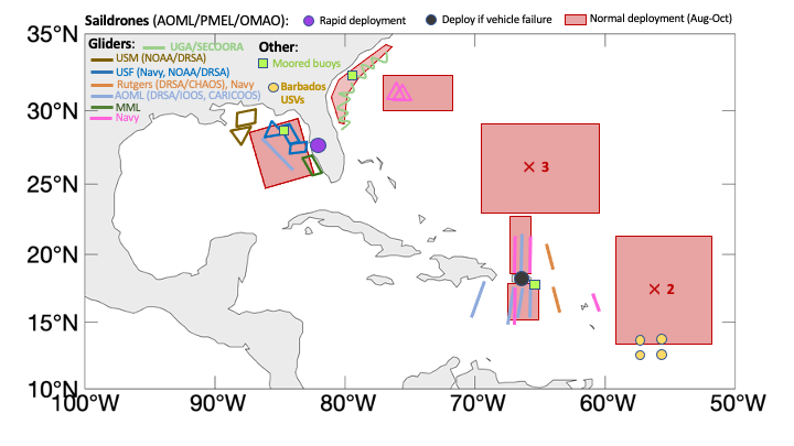
Twelve saildrones are planned to be deployed in the western Atlantic, Caribbean, and Gulf of Mexico during the 2023 Atlantic hurricane season, following the success of the experimental 2021 and 2022 missions.
Objectives
(1) Measure near-surface atmospheric and upper-ocean parameters to calculate energy and momentum fluxes between the atmosphere and ocean outside and within hurricanes.
(2) Synchronize the deployments of saildrones and other uncrewed systems (ocean gliders, airdrones) and conventional assets (moored buoys, airborne atmospheric dropsondes and oceanic profilers) to measure the air-sea transition zone (upper ocean, air-sea interface, and marine atmospheric boundary layer).
(3) Transmit data in real-time to operational weather prediction centers to improve atmosphere-ocean initial conditions in forecast models.
(4) Apply the observations to understand how air-sea interaction affects hurricane intensity and to advance hurricane prediction models.
(5) Experiment with a "delayed deployment" concept of operation. One USV is stationed onshore at the eastern coast of the Gulf of Mexico to be deployed when there is a predicted hurricane approaching the region ("rapid deployment"). Another USV is stationed in St Thomas, USVI in case there is a need to replace a malfunctioning vehicle in the area.
Deployments
Saildrone observations cover August 1-October 31, 2023 in seven areas (highlighted by red boxes in the map below) where chances of hurricane occurrence are high. Observations are sent to worldwide weather prediction centers in real time to assist their operational forecasts. Data are released for public use in near real time. This project also involves partnerships with NOAA's Environmental Modeling Center (EMC) of the National Weather Service and the CoastWatch of NOAA's National Environmental Satellite and Data Information Service (NESDIS).
The saildrone vehicle numbers, WMO IDs, and Maritime Mobile Service Identity (MMSI) numbers are given in the table below.
| Vehicle | WMO ID | MMSI # |
|---|---|---|
| 1031 | 1801556 | 338431523 |
| 1036 | 4803914 | 338431528 |
| 1040 | 1801560 | 338431533 |
| 1041 | 1801561 | 338431534 |
| 1042 | 1801562 | 338431535 |
| 1045 | 1801565 | 338431539 |
| 1057 | 1801577 | 338431553 |
| 1064 | 1801584 | 338431565 |
| 1065 | 1801585 | 338431566 |
| 1068 | 5801958 | 338431571 |
| 1069 | 5801959 | 338431573 |
| 1083 | 1801599 | 338431591 |
NOAA Mission Team:
Gregory Foltz, AOML (Co-Lead)
Chidong Zhang, PMEL (Co-Lead)
Andy Chiodi, PMEL/University of Washington
Catherine Edwards, Skidaway Institute of Oceanography, University of Georgia
Dongxiao Zhang, PMEL/University of Washington
Edward (Ned) Cokelet, PMEL
Eugene Burger, PMEL
Francis Bringas, AOML
Gustavo Goni, AOML
Hyun-Sook Kim, AOML
Kathleen E. Bailey, U.S. Integrated Ocean Observing System
Kevin O'Brien, PMEL/University of Washington
Joaquin Trinanes, AOML/University of Santiago, Spain
Jun Zhang, AOML/University of Miami
Lev Looney, AOML/University of Miami
Nan-Hsun Chi, PMEL
Hauke Schulz, PMEL/University of Washington
Ajda Saravin, PMEL/AOML
Edoardo Mazza, PMEL
This mission is supported by NOAA's Office of Oceanic and Atmospheric Research (OAR), NOAA's Office of Marine and Aviation Operations (OMAO), and Global Ocean Monitoring and Observing (GOMO) in collaboration with Saildrone, Inc.