One of the objectives of TOGA was to resolve the three-dimensional structure of planetary-scale disturbances along the equator so that daily wind profiles taken at a sufficiently dense horizontal scale were required. The distribution of existing WWW sites was of particular concern in the equatorial Pacific, having gaps which needed attention. Owing to the lack of suitable island sites and considering the logistic difficulty and expense of some of the candidate islands, only some of these gaps could be filled.
During the first few years of TOGA the International TOGA Project Office, with the assistance of many countries, concentrated on setting up observing capability at a number of sites: Kanton Island (Republic of Kiribati) and San Cristobal in the Galapagos, Gan in the Maldive Islands, and Penrhyn Islands. In addition, wind profilers were planned for a number of Pacific Islands (see section D2). These plans were set out in the first edition of the "TOGA International Implementation Plan" and were revised in later editions as circumstances changed. The final list of upper-air sites labeled as Key Stations for TOGA is given in the fourth and final edition of the "Implementation Plan" [International TOGA Project Office, 1992].
Two data sets were produced as a result of the data management of TOGA observations. Upper air reports transmitted on the GTS of the WWW were incorporated in the synoptic-time analyses and forecasts made by the operational forecast centers. The official TOGA archive of these data and the resulting analyses are those produced by the ECMWF. Another data set now exists at NCDC in Asheville, North Carolina, as a result of the Comprehensive Aerological Reference Data Set (CARDS) Program. This data set consists of all soundings made by the WWW and supplemental sites as forwarded by GTS and delayed mode to NCDC. Unfortunately, the CARDS rawinsonde data are spotty and concentrated in the last years of the TOGA experiment. The CARDS archive is available for use in research programs and, in particular, for current and future reanalysis efforts.
In 1985 the NOAA Aeronomy Laboratory in Boulder, Colorado, began to apply newly developed wind profiler technology to the TOGA program to support studies of the tropical atmosphere and climate system [Gage et al., 1990, 1991a]. The first step was taken at Christmas Island in the central Pacific Ocean island republic of Kiribati. A 50-MHz VHF wind profiler was constructed on Christmas Island in 1985 and has been operated nearly continuously since April 1986 [Gage et al., 1994a]. The VHF wind profiler observes horizontal and vertical velocities in the altitude range 1.8–18 km.
Christmas Island is located just north of the equator in the Line Islands south of Hawaii, as shown in Figure 5. The weather on Christmas Island is influenced by its location in the equatorial dry zone associated with the cold tongue of equatorial waters extending from the eastern Pacific across the central Pacific. Substantial rain occurs at Christmas Island only during ENSO warm events when the trade wind circulation relaxes and the cold tongue disappears. Some rain occurs in most years during March–May, when the Intertropical Convergence Zone (ITCZ) makes its closest approach to the equator. The wind profiler was placed at Christmas Island to determine the climatology of tropical wind fields and to observe the natural variability of winds over the central Pacific on the ENSO timescale.
Wind-profiling radars observe weak backscatter from turbulent irregularities in the atmospheric radio refractive index [see, e.g., Gage et al., 1990]. Wind velocity is inferred from the Doppler shift of the backscattered power in the direction of the radar beam. Most wind profilers operate with several fixed beams. Vertically directed beams are utilized for the measurement of vertical motions. Oblique beams (typically directed 15° off-zenith in orthogonal vertical planes) are utilized for the measurement of horizontal motions, since vertical motions are typically very small. In routine operation, orthogonal wind components are sampled every few minutes and processed to yield a consensus mean hourly wind. Typical precision expected for individual wind profiler measurements of horizontal velocities is close to 1 m s-1 [Strauch et al., 1987]. Four times per day, hourly averaged Christmas Island wind data are telemetered via geostationary satellite and incorporated onto the GTS for worldwide distribution.
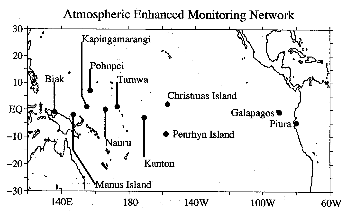
The Christmas Island wind profiler has served as a prototype for a complementary array of VHF wind profilers that was designed to span the Pacific basin from Indonesia to Peru. This Trans-Pacific Profiler Network was constructed with support from the National Science Foundation. It is comprised of VHF wind profilers at Pohnpei, Federated States of Micronesia; Biak, Indonesia; and Piura, Peru.
Island-based profilers are subject to local influences that may affect their ability to measure representative samples of the large-scale wind field. The magnitude of the local effects generally can be expected to decrease with height and depend on the location of the profiler and the size and topography of the island. For example, Balsley and Carter [1989] found lee waves in the vertical velocities that were pronounced at Pohnpei, an island with substantial topography, but absent at Christmas Island, which is very flat. Additional research is needed to quantify island influences on island-based profiler observations.
In order to observe the winds in the tropical lower troposphere the Aeronomy Laboratory developed an UHF boundary layer wind profiler to complement the VHF wind profiler [Ecklund et al., 1988, 1990]. The new UHF profiler operates at 915 MHz and observes winds in the lower troposphere up to 5–6 km with good vertical resolution. The 915-MHz profiler was installed at Christmas Island in 1990. Together the two profilers observe the entire tropical troposphere. UHF wind profilers are much more sensitive to hydrometeors than are VHF wind profilers; it is necessary to account for the fall speed of hydrometeors with UHF profilers to obtain accurate wind velocities when hydrometeors dominate the radar returns. Since the UHF profilers are very sensitive to hydrometeors [Gage et al., 1994b, 1996a; Ecklund et al., 1995], they are increasingly being used for precipitation studies in the tropics [Williams et al., 1995].
Technical aspects of the development of the 915-MHz UHF profiler are reviewed by Carter et al. [1995]. The profiler was adapted to shipboard operation [Carter et al., 1992] and integrated with a balloon sounding system and a suite of surface instruments to create an integrated sounding system (ISS), which formed a major part of the upper air sounding system used for TOGA COARE [Webster and Lukas, 1992; Parsons, 1994]. ISSs were operated for COARE on Kavieng and Manus Islands in Papua New Guinea, on Kapingamarangi in the Federated States of Micronesia, and on the Island Republic of Nauru in the central Pacific. Intercomparisons of UHF profiler wind and temperature measurements with balloon soundings at ISS sites show very good agreement during COARE [Riddle et al., 1996].
Return to Appendix C or go to Acknowledgments