U.S. Dept. of Commerce / NOAA / OAR / PMEL / Publications
On the Global Distribution of Hydrothermal Vent Fields
Edward T. Baker
NOAA/Pacific Marine Environmental Laboratory, Seattle, WA
Christopher R. German
Southampton Oceanography Centre, Southampton, UK
In Mid-Ocean Ridges: Hydrothermal Interactions Between the Lithosphere
and Oceans, Geophysical Monograph Series 148, C.R. German, J. Lin, and
L.M. Parson (eds.), 245–266 (2004)
Copyright ©2004 by the American Geophysical Union. Further electronic
distribution is not allowed.
4. "SLOW" RIDGES
We define "slow" ridges as those with deep, spacious, and generally enclosed rift valleys, commonly with several hundreds of meters of relief, typically spreading at rates between 20 and 55 mm/yr (we discuss ultraslow-spreading ridges separately, below). These characteristics create a challenging environment for identifying and locating vent sites. The frequent absence of a well-defined neovolcanic zone and the presence of deep and enduring faults that facilitate the discharge of hydrothermal circulation over a broad expanse of seafloor make survey strategies far more complex than on fast ridges. Even when plumes are detected, their source is typically not obvious because the rift valley relief may trap and disperse a plume throughout much or all of an individual tectonic segment [e.g., German et al., 1998b; Bougault et al., 1998].
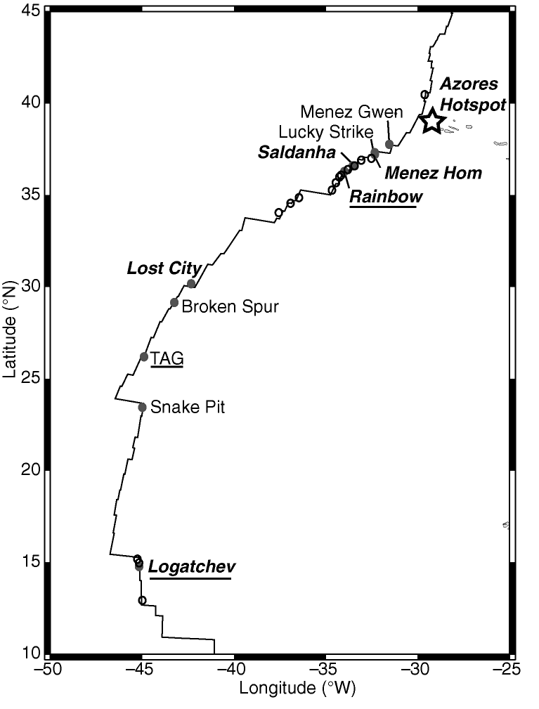
The first systematic investigations for submarine hydrothermal activity on any slow-spreading ridge were conducted on the northern MAR (11°–26°N) in the 1980s [Klinkhammer et al., 1985; Bougault et al., 1990; Charlou and Donval, 1993]. Those preliminary investigations relied upon vertical casts within individual segments of the MAR rift valley to detect midwater chemical anomalies (e.g., total dissolvable (TD)Mn, dissolved CH ) indicative of hydrothermal discharge from the seafloor. This "point-sampling" approach found midwater TDMn anomalies in nine segments of the MAR between 11° and 26°N [Klinkhammer et al., 1985], and midwater CH enrichments in 14 segments within the same region [Charlou and Donval, 1993]. Subsequent detailed studies within this region discovered major vent fields such as TAG [Rona et al., 1986], Snake Pit [ODP Leg 106 Scientific Party, 1986], and Logatchev [Krasnov et al., 1995]. Other "point-sampling" surveys have identified more than 10 additional sites between 40°N and 8°S where chemical and/or optical anomalies indicate the presence of hydrothermal plumes but are insufficient to locate the precise source of venting (Figure 6) [e.g. Charlou et al., 1991; Aballéa et al., 1998; Chin et al., 1998; German et al., 2002].
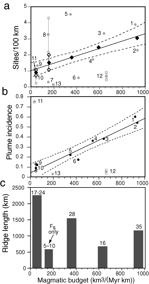
Unlike on fast ridges, plume surveys on slow ridges have been either too imprecise or too short to yield reliable estimates of ph. (Note that we are here adopting a more rigorous interpretation than we have used earlier [e.g., Baker et al., 1995, 1996], where MAR ph values were estimated from vent site frequency.) Lengthy surveys have been conducted from 27° to 30°N [Murton et al., 1994] and 35.7° to 38°N [German et al., 1996a], but in both cases using only a single transmissometer mounted on the Towed Ocean Bottom Instrument (TOBI) sidescan vehicle towed 150–500 m above bottom. Plumes have been mapped in detail along the Broken Spur [German et al., 1999] and Rainbow [German et al., 1996b] segments, but both surveys extended for no more than ~50 km along axis.
While we have insufficient data to reliably determine ph, we can calculate minimum estimates of Fs for the two MAR sections mentioned above (we discuss the Reykjanes Ridge below). From 27° to 30°N only the Broken Spur vent field is known [German et al., 1999], yielding a minimum Fs of 0.30. Multiple surveys in the 35.7°–38°N section have located at least three high-temperature hydrothermal sites (Menez Gwen [Fouquet et al., 1995], Lucky Strike [Langmuir et al., 1993], and Rainbow [German et al., 1996b; Fouquet et al., 1997]), and two low-temperature sites (Mt. Saldanha [Barriga et al., 1998] and Menez Hom [Fouquet et al. 2002]). Five other sites have been inferred from water column profiles only (in the South Lucky Strike, north FAMOUS, AMAR, and South AMAR segment sections [German et al., 1996a; Chin et al., 1998]), but these inferences are based on very limited data. Fs values thus range from 2.2 to 4.3. Merging the 27°–30°N and 35.7°–38°N sections results in an Fs of 1.5 over 560 km of ridge crest (Figure 5a). German and Parson [1998] undertook a similar analysis over a more extended ridge length with consequently weaker data constraints. They found a vent field spacing of ~130 km from 11°–30°N (Fs = 0.77), shrinking to every 30 km from 35.7°–38°N ( Fs = 3.3). Merging these two estimates yields a mean Fs of 1.3, consistent with our analysis of the combined 27°–30° and 35.7°–38°N regions (Fs = 1.5).
These MAR surveys have documented that hydrothermal activity on slow ridges can be influenced not only by the magmatic budget but by local tectonic processes as well. Sites closely associated with axial neovolcanic activity include Menez Gwen, Lucky Strike, Broken Spur, and Snake Pit (Figure 6). Other sites occur not at magma-rich segment centers but at the confluence of cross-cutting fault populations on segment walls (TAG, Logatchev), or in segment-end nontransform offsets (NTOs) (Rainbow, Mt. Saldanha, Menez Hom, and other unnamed sites). The apparent increased incidence of venting between 35.7°N and 38°N, compared to the Kane-Atlantis (24°–30°N) section (Figure 6), led to a "tectonic control of venting" hypothesis [German et al., 1996a; German and Parson, 1998; Gràcia et al., 2000; Parson et al., 2000]. This hypothesis argues that obliquity of the axial strike in the 35.7°–38°N area results in a greater number of short 2nd-order ridge segments and larger NTOs than found farther south. Crustal permeability is enhanced within the NTOs by deeply penetrating and long-lived faults, allowing seawater to mine heat not only from crustal magma but also from gabbroic intrusions or cooling in the lithospheric mantle [Cannat et al., 2004], and from exothermic serpentinization [Schroeder et al. 2002; Lowell and Rona, 2002]. Recent drilling at 14°–16°N on the MAR, for example, suggests the crust there may be 25% gabbroic [Kelemen, 2003], and crystallization of such rocks at depths to 20 km might provide a deep heat source in basalt-poor ridge segments. The Rainbow vent field perhaps best exemplifies this hypothesis: it is situated at the intersection of the ridge-axis and an NTO, at 36.25°N on the MAR, and vents 362°C "black smoker" fluids with distinctive chemical compositions indicative of "contamination" by the products of serpentinization reactions at depth [Holm and Charlou, 2001; Douville et al., 2002; Charlou et al., 2002]. Sites such as the Lost City Field at 30°N [Kelley et al., 2001] and Mt. Saldanha at 36.51° [Barriga et al., 1998] appear to be driven almost purely by serpentinization. Their low temperature (<100°C) and metal-poor (and thus optically invisible) discharge makes systematic searches for additional sites of this type, which may be pervasive along all slow-spreading ridges, a demanding future challenge.
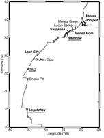
Figure 6. Known (solid circles) and inferred (open circles) vents sites along the northern Mid-Atlantic Ridge. Sites sited on axial neovolcanic highs are in plain type, sites hosted at least partially in ultramafic rocks are in italics, and sites apparently controlled by cross-cutting fault populations are underlined. Unlike the situation on most fast-spreading ridges, many of the inferred vent sites are based on single vertical profiles and have a high degree of uncertainty.
If processes other than variability in the magmatic budget play a significant role in controlling the distribution of hydrothermal activity on slow ridges, we might expect the MAR not to agree with the trend of fast ridges on a plot of Fs vs. Vm. While Fs for the 27°–30°N and 35.7°–38°N MAR sections are quite different, their weighted mean value closely follows the fast ridge trend (Figure 5a). Thus, the available data are insufficient to reject the magmatic budget hypothesis for slow ridges. While significant departures from the linear trend are clearly observed along individual short segments, what is indisputable is that more extensive and systematic surveys along slow-spreading (20–55 mm/yr) ridges are required to fully test the hypothesis. Currently, the database for these ridges is smaller than for any other ridge class, even though they constitute ~40% of the global ridge total (Figure 5c).
Return to previous section or go to next section
PMEL Outstanding Papers
PMEL Publications Search
PMEL Homepage