U.S. Dept. of Commerce / NOAA / OAR / PMEL / Publications
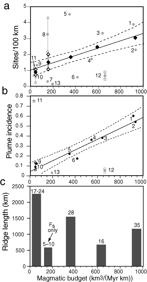
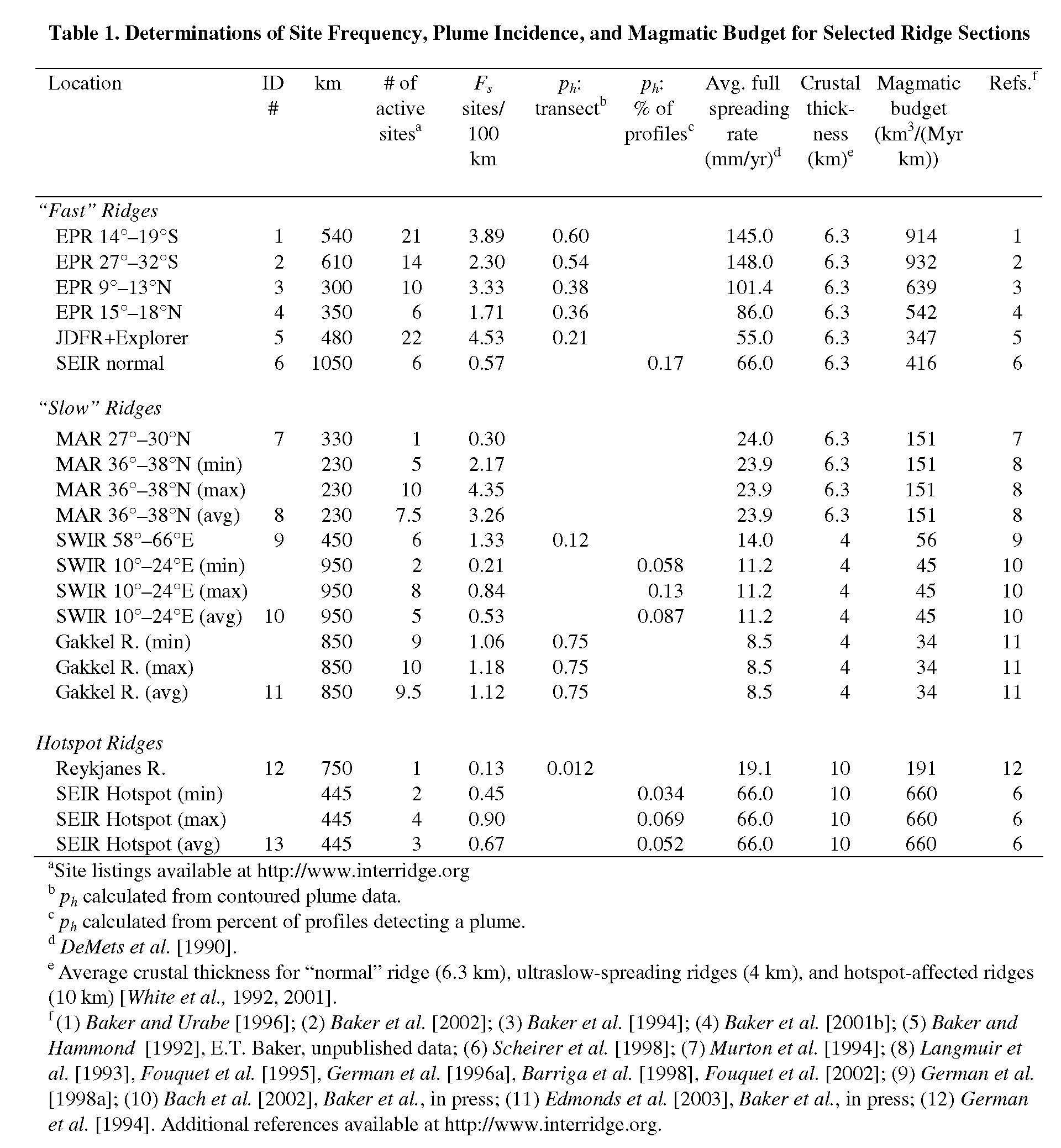
Ultraslow ridges are of particular interest because both geochemical and geophysical inferences indicate that the amount of melt generated in the mantle beneath ridges decreases abruptly as spreading rates drop below ~20 mm/yr [Reid and Jackson, 1981; White et al., 2001]. Magmatism becomes discontinuous and mantle peridotite is emplaced directly to the seafloor over broad areas, creating a class of ridge fundamentally different from all faster-spreading ridges [Dick et al., 2003]. If the spatial density of hydrothermal circulation is directly related to magma budget, then the frequency of vent fields on ultraslow ridges should be even less than that predicted by the spreading rate alone.
In the last few years, detailed plume surveys have been conducted along three long sections of ultraslow-spreading ridge: two sections of the eastern South West Indian Ridge (SWIR) between 58° and 66°E (14–16 mm/yr full rate) [German et al., 1998a]; the western SWIR, 10°–23°E (8–14 mm/yr) [Bach et al., 2002; Baker et al., 2004]; and the Gakkel Ridge, 7°W–86°E (6–11 mm/yr) [Edmonds et al., 2003]. Detailed analyses of plume and vent field distributions along these ridge sections suggest that hydrothermal activity along each is similar.
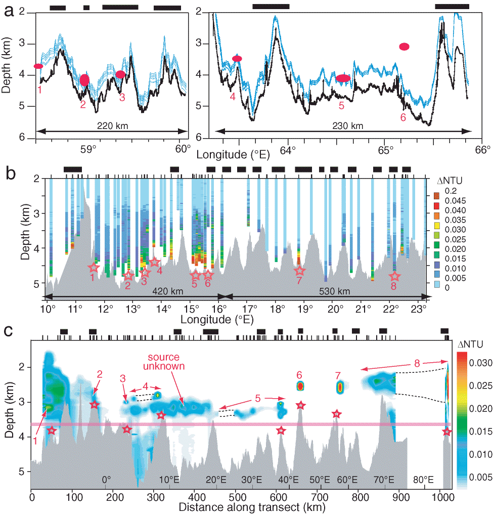
The only ultraslow ridge sections where plumes have been mapped using a continuous tow method are two segments of the eastern SWIR between 58° and 66°E [German et al., 1998a]. This study located six possible hydrothermal sites using dual-pass tracks of TOBI, with an array of MAPRs spanning a 300-m-thick layer above and below the package. The TOBI data mapped laterally continuous, above-bottom optical anomalies with distinct geographical limits, strongly indicative of hydrothermal rather than erosional origins (Plate 1a). The total plume extent of 50 km within the 420 aggregate km of ridge length studied results in ph = 0.12, consistent with a low Fs of 1.33 (Figure 5). For the 10°–23°E SWIR, ph was calculated from the percentage of vertical MAPR profiles that recorded a plume. Of the 86 profiles collected on cruises in 2000/2001 and 2003 (Plate 1b), at least five and a maximum of 11 detected hydrothermal plumes, yielding a ph of 0.06 to 0.13 and Fs values of 0.21–0.84 (Figure 5), although these maximum values are not tightly constrained. There is an unusually high level of uncertainty here, because Antarctic Bottom Water flowing into this section from the bounding fracture zones appears to induce widespread resuspension of bottom sediments, complicating the identification of hydrothermally derived optical anomalies [Baker et al., 2004].
Plate 1. Along-axis transects of  NTU for the (a) SWIR 58.5°–66°E, (b) SWIR 10°–23°E, and (c) Gakkel Ridge (4°W–86°E). Black bars above each panel show approximate location of volcanic centers [Grindlay et al., 1998; Sauter et al., 2002; Cannat et al., 2003; Dick et al., 2003; Michael et al., 2003]. In (a) the MAPR paths (light blue) intersected six incidences of NTU (red symbols) while following the bathymetry (heavy black line).This diagram shows only one of two parallel tracks; the plume at 65.12°E was detected on the other track, which followed a slightly different bathymetry. In (b) NTU data are displayed as individual profiles to avoid contouring artifacts. Not all casts were made at the rift axis, so profile depths may be deeper or shallower than the bathymetric profile at the same longitude. Stars mark sites where hydrothermal activity is probable. In (c) MAPR data was sufficiently dense to contour [Baker et al., 2004]. Numbers mark individual plumes and the possible seafloor source location of each is shown by the underlying stars; source location of the extensive plume from 250–450 km along section, centered at ~3200 m, is unknown. Most of the NTU anomaly west of ~150 km has no thermal expression and is thus nonhydrothermal [Baker et al., 2004]. Supplementary x-axis scale gives longitude along the transect. Pink line indicates approximate top of the bottom isopycnal layer.
The Gakkel Ridge, the slowest-spreading and perhaps deepest section of the global ridge system, crosses ~1800 km of the Arctic Ocean from Greenland to Siberia. The Arctic Mid-Ocean Ridge Expedition in 2001 collected 145 MAPR profiles over 850 km of the western half of the ridge (average spacing 6.6 km), and 114 displayed light-scattering (and often temperature) anomalies characteristic of hydrothermal plumes [Edmonds et al., 2003]. Calculating the ph value either from the fraction of MAPR profiles that detected a hydrothermal plume (0.82) or from the axial plume coverage based on contouring the gridded data set (0.75, Plate 1c) yields the highest ph yet documented on any lengthy ridge section (Figure 5b). Because of the remarkable hydrographic characteristics over the Gakkel Ridge and the unusual bathymetric characteristics of ultraslow ridges in general, however, this exceptional ph value is not representative of the relative spatial density of hydrothermal sites. The water column below ~3500 m is effectively isopycnal within the Gakkel Ridge, allowing plumes to rise above the axial bathymetry (Plate 1c). The capacious and continuous axial valley traps many of these plumes, permitting some to disperse coherently for up to 200 km [Edmonds et al., 2003; Baker et al., 2004]. This situation is a cautionary lesson about the limitations of interpreting ph in axial valleys of great relief, an even more extreme example than the Rainbow plume on the MAR, which has been traced at least 50 km downstream from its source [German et al., 1998b; Thurnherr et al., 2002]. Careful analysis indicates that despite an extreme ph, only 9–10 hydrothermal fields are active on the Gakkel Ridge [Edmonds et al., 2003; Baker et al., 2004], so Fs = 1.1–1.2.
Adding the results from ultraslow ridges to Figure 5 shows, except for the anomalous ph value of the Gakkel Ridge, good agreement with the trend of faster-spreading ridges. Values for ph on the SWIR are ~0.1 and Fs values on all three sections are ~1. Vm values for these ridges are computed using a nominal crustal thickness of 4 km [White et al., 2001], though seismic observations [Muller et al., 1999; Jokat et al., 2003] have found thicknesses of < 2 km. Moreover, dredging and magnetic surveys of ultraslow ridges indicate that large sections may actually have near-zero crustal thickness, unless serpentinized peridotite is regarded as "crust" [Dick et al., 2003]. The Vm estimates for ultraslow ridges (Table 1) are, therefore, maximum values.
The presence of NTU plumes over both volcanic and avolcanic areas on these ridges (Plate 1) indicates that hydrothermal activity on ultraslow ridges cannot be simply related to the magmatic budget. Whereas at least six of the nine identified sites along the Gakkel Ridge occur on axial volcanic highs [Edmonds et al., 2003; Baker et al., 2004], sites on the SWIR appear more controlled by the tectonic environment. Enhanced permeability created by the long-lived and deeply penetrating fault planes that are a hallmark of ultraslow ridges [Dick et al., 2003] can provide access to nonvolcanic heat sources such as direct cooling of the upwelling mantle and exothermic serpentinization. For example, the strongest plume on the western SWIR, at ~13.3°E (Plate 1b), was found along the wall of a large fault block with a 1200 m footwall extending from valley floor to the crest of the rift valley wall [Bach et al., 2002]. Fossil hydrothermal deposits in the western SWIR were primarily found on the rift valley walls, further emphasizing the role of tectonism in controlling hydrothermal activity there [Bach et al., 2002; Dick et al., 2003]. On the eastern SWIR, several bathymetric highs identify locations of focused volcanism [Münch et al., 2001; Sauter et al., 2002; Cannat et al., 2003], but at least half the detected plumes occur in the weakly volcanic zones (as determined from sidescan sonar imagery). None were observed around the summits of the major bathymetric highs [German et al., 1998a]. Analyses of core-top sediments have confirmed the presence of geologically recent vent activity near plume signals at both volcanically and tectonically dominated sites on the eastern SWIR [German, 2003], consistent with inferences from the western SWIR that hydrothermal discharge occurs in both volcanic and nonvolcanic settings.
Clearly, we should anticipate a greater complexity in the nature of hydrothermal activity on weakly volcanic crust than would ever have been predicted from studies of fast-spreading ridges alone. Improved understanding of this aspect of heat transfer and hydrothermal circulation will only be disclosed by direct observation of seafloor processes at ultraslow-spreading ridges, a prime target for InterRIDGE-coordinated research in the future.
Return to previous section or go to next section