U.S. Dept. of Commerce / NOAA / OAR / PMEL / Publications
On the Global Distribution of Hydrothermal Vent Fields
Edward T. Baker
NOAA/Pacific Marine Environmental Laboratory, Seattle, WA
Christopher R. German
Southampton Oceanography Centre, Southampton, UK
In Mid-Ocean Ridges: Hydrothermal Interactions Between the Lithosphere
and Oceans, Geophysical Monograph Series 148, C.R. German, J. Lin, and
L.M. Parson (eds.), 245–266 (2004)
Copyright ©2004 by the American Geophysical Union. Further electronic
distribution is not allowed.
3. "FAST" RIDGES
"Fast" ridges are defined here as those having a narrow and shallow (relief on the order of 100 m or less) axial valley. This category typically ranges from intermediate (55–80 mm/yr) to superfast (>140 mm/yr) spreading rates. We use this definition because it describes ridge sections where virtually all detectable hydrothermal discharge is concentrated in or near a narrow neovolcanic zone, and where hydrothermal plumes can be readily dispersed off axis by local currents. These qualities allow efficient and credible surveying for hydrothermal plumes (and their seafloor sources), and make it likely that the plume distribution will be a reliable indicator of the location and extent of the seafloor sources (i.e., plumes are unlikely to be transported long distances along axis).
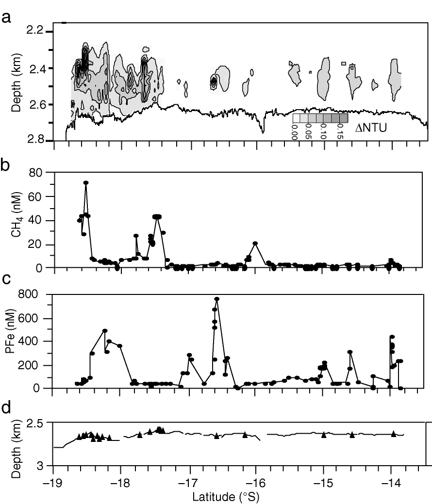
Among the best places to demonstrate the capability of optical plume transects to denote the spatial density of seafloor vent fields is the EPR between 13.5° and 18.67°S (Figure 3), the focus of several submersible, remotely or autonomously operated vehicle, and plume survey campaigns that have systematically surveyed for vent sites [Renard et al., 1985; Urabe et al., 1995; Auzende et al., 1996; Haymon et al., 1997; Lupton et al., 1997; Embley et al., 1998; Von Damm et al., 1999; Lupton et al., 1999; Wright et al., 2002]. A continuous plume transect here using an optical light backscattering sensor on a conductivity-temperature-depth-optical (CTDO) package in the "tow-yo" mode [Baker et al., 1995] found ph = 0.60 [Baker and Urabe, 1996]. Comparing the  NTU distribution with discrete particulate (Fe) and dissolved (CH
 ) chemical tracers confirms that the optical signal reliably described the distribution of all significant hydrothermal plumes on this section of the EPR (Figure 3). How well does the plume data reflect the seafloor sources? Water column data identify approximately six discrete plume maxima between 14° and 17°S, plus a continuous and variable plume from 17.33° to 18.67°S (Figure 3a). While submersible and remotely/autonomously operated vehicle expeditions have transited only ~10% of this ridge section, these expeditions have nevertheless located active vent fields under five of the discrete plumes and throughout the 17.33°–18.67°S area. This substantial agreement between the location of the mapped vent fields and hydrothermal plumes implies that no significant vent fields went undetected by the plume surveys, though future volcanic activity will certainly create new fields even as some old fields grow extinct.
Figure 3. Along-axis transect of (a) light-scattering, (b) dissolved CH, and (c) particulate Fe from 13.5° to 18.67°S on the East Pacific Rise. Light-scattering data collected with a series of continuous CTDO tow-yos. Discrete CH and Fe samples (solid circles) from bottle samples and vertical casts. Note that some plumes are volatile rich (e.g., near 18.5°S and 17.67°), while others are metal rich (e.g., near 18°, 16.5°, and 14°S). Location of known vent areas (solid triangles) shown in (d).
In addition to the EPR section described above, continuous plume data have been acquired along three other multisegment sections of fast-spreading ridge: the Juan de Fuca/Explorer Ridge [Baker and Hammond, 1992; E.T. Baker, unpublished data], the EPR 8.67°–11.83°N [Baker et al., 1994], and the EPR 27.5°–32.3°S [Baker et al., 2002] (Table 1). To compare the plume distributions along all four ridge sections, we compile transects of vertically integrated NTU ( NTU). NTU is calculated by gridding the two-dimensional NTU transects (e.g., Figure 3a) at cell sizes of x = 0.03° of latitude (~3 km), y = 25 m, then vertically summing NTU in each x interval from the seafloor to plume top. The NTU plots (Figure 4) illustrate that as spreading rate increases not only does ph increase, but so does the along-axis extent of the largest plume features. On superfast ridge sections, vent sources can be so extensive that plumes are continuous for upwards of 100 km along axis.
Two other fast ridge sections without continuous plume data still meet the criteria of having multisegment extent and a sufficiently high density of individual plume profile data to reliably calculate ph: the EPR 15.33°–18.5°N [Baker et al., 2001b] and the South East Indian Ridge (SEIR) 77°–88°E [Scheirer et al., 1998]. For these types of data sets, Scheirer et al. [1998] argued that sufficiently closely spaced vertical profiles represent a statistically valid subsampling of the continuous plume distribution, such that the ph value is equivalent to the percentage of vertical profiles that detect a hydrothermal plume. The SEIR section is unusual in that about one third of the ridge length studied bisects the Amsterdam-St. Paul Plateau, a hotspot location with a crustal thickness of ~10 km [Scheirer et al., 2000]. Hydrothermal plumes there were mapped using 81 vertical light-scattering/temperature profiles collected at an average spacing of 18 km with Miniature Autonomous Plume Recorders (MAPRs [Baker and Milburn, 1997]) attached to dredges and rock cores. Scheirer et al. [1998] recognized plumes on 11 of those 81 profiles (including one in the caldera of an off-axis volcano), yielding a maximum ph of 0.14 for the entire area. For reasons we discuss below, hydrothermal circulation along ridge sections that overlie mantle hotspots may be markedly affected by their characteristic thickened crust and higher mantle temperatures [e.g., Chen, 2003]. We have partitioned our data for the SEIR survey, therefore, into those ridge sections intersecting the hotspot influence and those adjacent to it [Scheirer et al., 2000]. Outside of the hotspot-influenced region, 36 profiles along 1050 km of ridge axis produced 6 plume sites, for a ph = 0.17.
The data summarized above span spreading rates from intermediate to superfast, and if the long-term magma budget is the primary control on hydrothermal activity we should expect a robust correlation between the magma delivery rate, Vm, and both ph and Fs. We estimate Vm from
Vm = Tcus
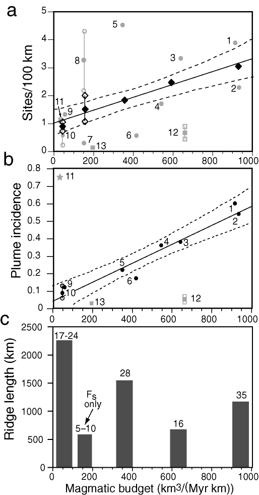
where Tc is the nominal crustal thickness of 6.3 ± 0.9 km for ridges with a full spreading rate (us) > 20 mm/yr [White et al., 1992, 2001] (Table 1). Plotting Fs (Table 1) against Vm yields a scattered relationship that reflects not only the observed distribution of hydrothermal activity, but also the current intensity of seafloor exploration effort and the uncertainty in enumerating vent fields on fast-spreading ridges (Figure 5a). The JDFR has been explored for over 20 years, while a submersible has yet to visit the EPR 15.33°–18.5°N or SEIR areas. We can improve the statistics dramatically, however, by binning these six sections according to superfast, fast, and intermediate spreading rates so that each data point represents at least 500 km of ridge length (Figure 5c). The more robust relationship obtained by plotting p against Vm demonstrates the integrating value of multisegment plume surveys in determining relative hydrothermal activity (Figure 5b). The evidence is compelling in either case: multisegment hydrothermal activity along "fast" ridges is primarily controlled by the magmatic budget.
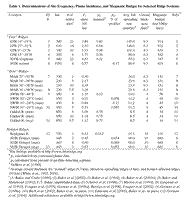
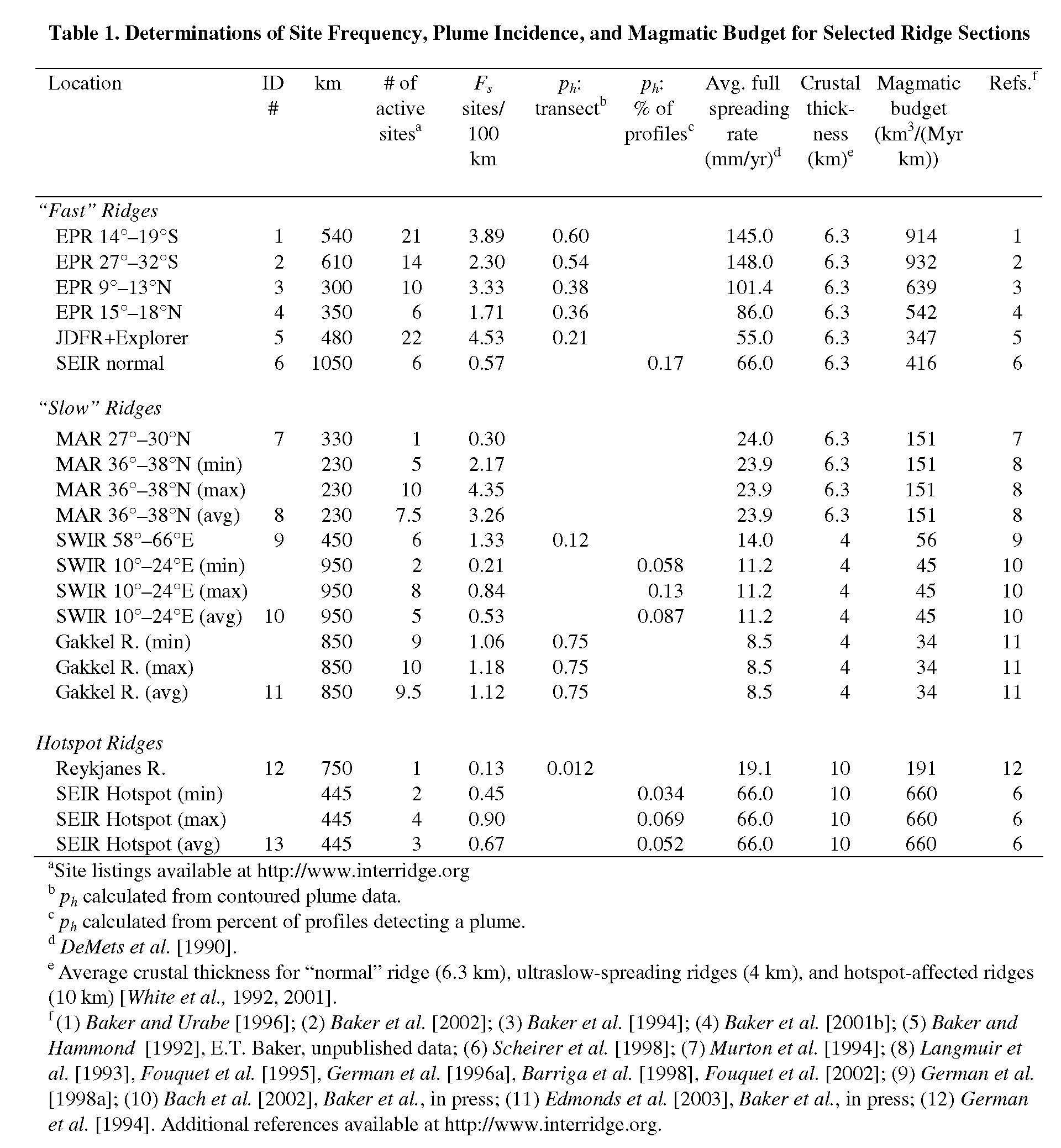
Table 1. Determination of Site Frequency, Plume Incidence, and Magmatic Budget for Selected Ridge Sections
Figure 4. Vertically integrated NTU transects from sections of fast ridges. NTU values were determined by gridding continuous NTU data into cells of 0.03° latitude along axis by 25 m thick from the top of the plume to the seafloor, then summing NTU values vertically in each latitude bin. Shaded areas identify regions where light-scattering plumes are continuous along axis. The fraction of the total surveyed areas covered by these regions (ph) increases with increasing spreading rate: (a) Juan de Fuca Ridge (55 mm/yr), ph = 0.23; (b) northern East Pacific Rise (103 mm/yr), ph = 0.38; (c) southern EPR (148 mm/yr), ph = 0.60; (d) southern EPR (148 mm/yr), ph = 0.54. Locations of known vent fields (solid triangles) indicated along the bottom of each transect.

Figure 5. (a) Scatter plot of hydrothermal sites/100 km of ridge length (Fs) vs. magmatic budget (Vm). Numbers refer to ridge sections identified in Table 1. Sections 8, 10, 11, and 12 show high and low estimates with open symbols, mean estimate with solid symbol. Squares indicate hotspot-affected ridges. Black diamonds show binned data (not including sections 12 or 13), with least-squares regression fit of Fs = 1.01 + 0.0023Vm (r2 = 0.97). 95% confidence bands for prediction of Fs from Vm given by dotted lines. (b) Plume incidence (ph) vs. Vm, with symbols as in (a). Least-squares regression fit of ph = 0.043 + 0.00055Vm (r2 = 0.93), excluding sections 11–13 (see text). Note also there is no data point for slow-spreading (non-hotspot-affected) ridges. (c) Total ridge length and number of vent sites in each of the five bins in (a).
Return to previous section or go to next section
PMEL Outstanding Papers
PMEL Publications Search
PMEL Homepage