Work in progress: Cloud Forcing in the eastern tropical Pacific
Work in progress:
Cloud forcing in the eastern tropical Pacific.
Meghan F. Cronin (NOAA / PMEL), Nick Bond (NOAA / JISAO), Chris Fairall (NOAA / ETL) and Bob Weller (WHOI)
This webpage is no longer in use. Please see published results:
Cronin, M. F., N. A. Bond, C. W. Fairall, and R. A. Weller.
Surface cloud
forcing in the east Pacific stratus deck/cold tongue/ITCZ complex.
J. Climate, 19(3), 392-409, 2006.
EPIC2001 workshop poster
Figures for manuscript.
Outline:
- Biases in tropical general circulation models. "The big bugaloo
is clouds -- cloud formation, and proper radiative properties."
- What is cloud forcing magnitude at surface, structure and variability?
done
- How well do NCEP2 and ECMWF reproduce the observed cloud forcing?
done
How well do buoy observed cloud forcing compare to ISCCP?
done
- Are biases in cloud forcing consistent with biases in GCMs?
done
- Why do NCEP2 and ECMWF fail when they do? Why does ISCCP differ
from buoys?
- Clearsky models, Optical depths, etc. -- look at clearsky values.
done
- Background moisture? -- compare sounding section for worst (NCEP2).
partly done
- Proper cloud type formation? -- compare cfrs vs. cfrl for different
regions
under precipitating & non-precipitating conditions. done
- Is the solar and longwave cloud forcing equal and opposite?
... in some regions?
done.. although this is picked up in next paper.
... in which case clouds have no effect on the
surface radiation. A surprizing result to an oceanographer. The
heat balance on the ocean will be defered to the next paper. Here,
we just want to know if the clouds affect the ocean heat budget or not.
- How can the best field (ISCCP) be improved based on buoy
measurements? done
- correct Rs based on Rs (correction largest when clearsky) -- Rs_cor ~ (1-f)* Rs
- correct Rs based on CFRs (correction largest when cloudy) -- Rs_cor ~ Rs - (f*CFRs)
1. Introduction
Poor representation of Clouds in models --> biases in coupled models.
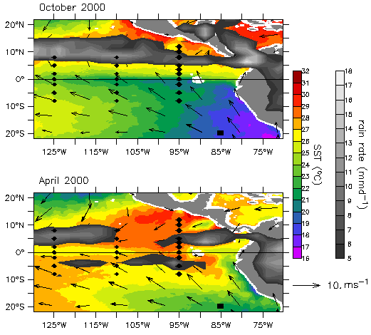
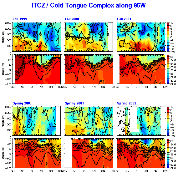
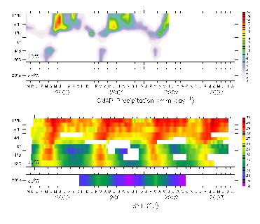
Purpose of EPIC -- Fig. 1.
Purpose of this analysis.
|
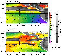
Fig. 1. The EPIC array shown in relation to the April & October 2000 averaged
TMI SST and QuickSCAT wind stress & CMAP rain fields --
95W Moorings cross the ITCZ/Cold Tongue complex. IMET buoy in the stratus
region.
* Note that the deep convection is over the warmest waters. Clouds are
sensitive to SST, but also affect SST. Coupled problem.
* Double ITCZ is observed sometimes in springtime! Southern hemisphere ITCZ over water > 28C.
*Model biases include a persistent double ITCZ, cold tongue that is too cold, and southern hemisphere SST that is too warm.
* Purpose of EPIC. 95W TAO moorings & IMET mooring.
|
2. Methodology and Data
Cloud Forcing = Observed Downwelling Radiation - Clearsky value.
Clearsky solar radiation depends upon...
Clearsky longwave radiation depends upon ...
EPIC array of moorings measure...
Can compute clearsky and cloud forcing...
Will use satellite data (TMI SST, TRMM rainfall,
quikscat winds) to relate the moorings to large-scale fields...
Will compare to monthly ISCCP cloud forcing...
Will compare to NCEP2 reanalysis monthly averaged cloud forcing through aug 2003, and ECMWF for monthly averaged cloud forcing through ....
All fields will be shown on original grid, and then will be remapped
onto buoy monthly grid to analyze differences from buoys.
3. Results
3.1 Solar and longwave cloud forcing timeseries
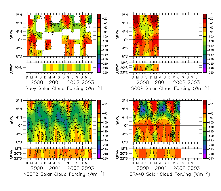
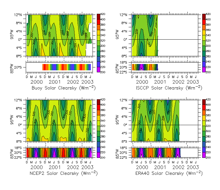
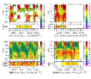
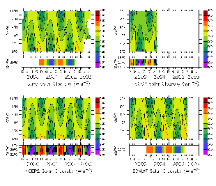
Fig. 2.
Left figure: Solar cloud forcing from buoys, NCEP2, ISCCP and ECMWF.
Middle figure: The difference between NCEP2, ISCCP, and ECMWF solar
cloud forcing and buoy solar cloud forcing (CFRS).
|
|
|
Comments about TAO solar cloud forcing
Largest CFRS (reduction in SWR due to clouds) in ITCZ.
Cold tongue frontal region (equator to 5N) has ~clearskies during FMA.
Comments about NCEP2 solar cloud forcing
NCEP2 solar cloudforcing is stronger than observed (too cloudy). (cold bias)
Don't have clearskies in north during warm season.
Tend to have very dark, cloudy skies near frontal region throughout year
in NCEP2. This could lead to 7C SST bias in 3 months assuming 30m thick MLD.
20S is much clearer than observations. (warm bias)
Comments about ISCCP solar cloud forcing
Clearsky ~ 10-12N during JFM (similar to buoys).
At all sites, CFRS is less strong than buoys. (warm bias at all sites).
Comments about ECMWF solar cloud forcing
95W much cloudier than in observations. (cold bias)
20S is uniformly cloudy.
|
|
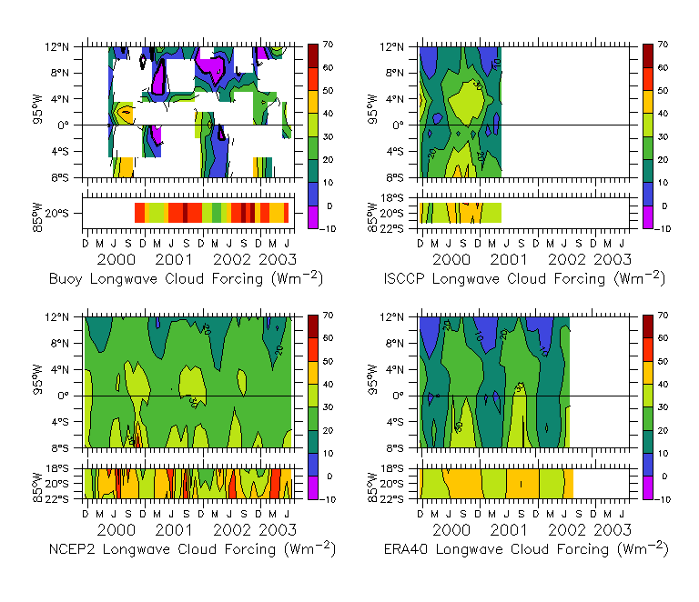
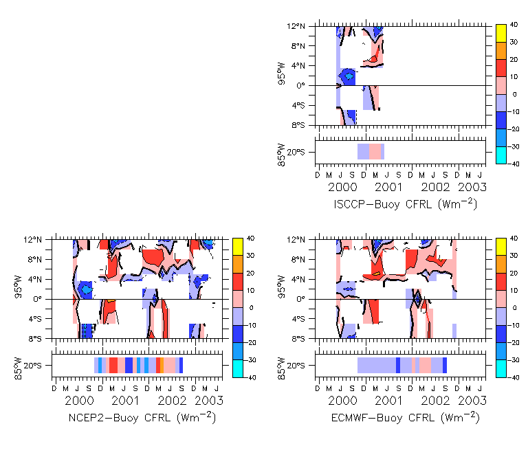
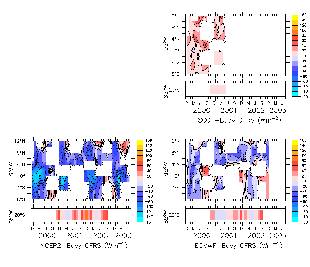
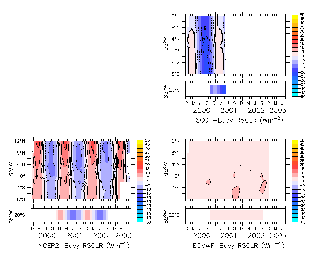
Fig. 3.
Left figure: Longwave cloud forcing from buoys, NCEP2, ISCCP and ECMWF.
Middle figure: The difference between NCEP2, ISCCP, and ECMWF solar
cloud forcing and buoy longwave cloud forcing (CFRL).
|
Comments about TAO longwave cloud forcing
CFRL magnitude is less than CFRS
Cold tongue frontal region (equator to 5N) has largest CFRL.
Clouds have less effect on LWR in northern hemisphere than S.H..
Do we believe these Negative CFRL? Do we believe very strong positive CFRL?
Comments about NCEP2 longwave cloud forcing
mean meridional gradient. CFRL strongest in sh.
little variability in CFRL.
difference from buoys is sometimes pos & neg.
Comments about ISCCP longwave cloud forcing
ISCCP longwave cloudforcing doesn't have as much range as buoys,
but more than NCEP2.
Comments on ECMWF CFRL
Matches buoys better than NCEP2 does.
|
|
3.2 Diagnosing the differences
3.2.1 Are wrong type of clouds being formed?
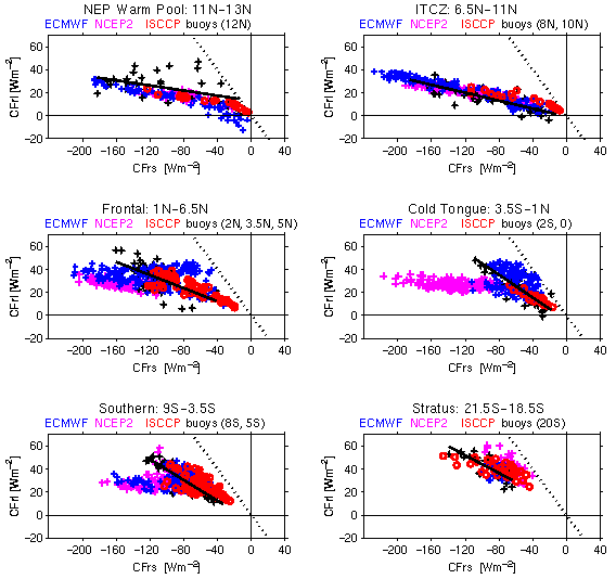
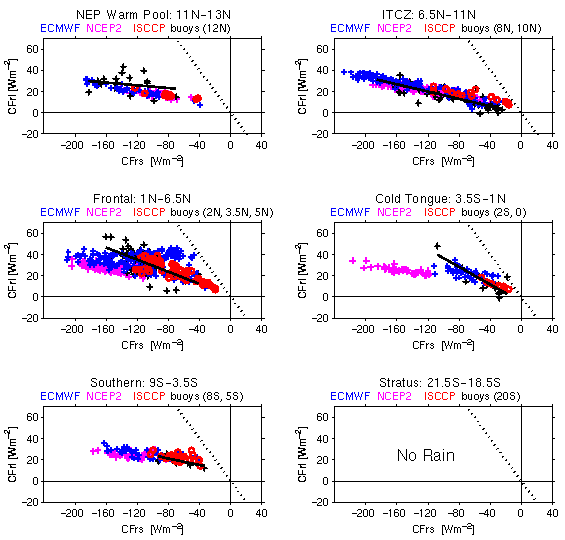
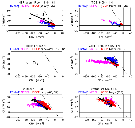
Fig. 4. Scatter plot of solar cloud forcing (x-axis) vs. longwave cloud forcing (y-axis)
for each latitudinal band, using monthly averaged buoy data (black), ECMWF data (blue),
NCEP2 values (magenta), and ISCCP (red circles).
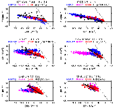
For Full Time Period
|
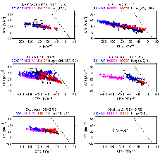
For Precipitating Clouds
|
For Non-Precipiting Clouds
|
Results:
NCEP2 does not capture cold tongue near 1-1 relation. Instead,
NCEP2 tends to produce ITCZ type clouds in cold tongue region.
There was no significant rainy months in the stratus deck region, and
no significant dry months in the frontal region.
Slope in southern region during Rainy months is similiar to slope
in ITCZ region -- ITCZ radiative properties are similar, whether in
NH or SH. (although range of cloud forcing is less in sh ITCZ than in nh ITCZ).
In the southern region, the slope |CFRL/CFRS| increased during
dry periods. This change in radiative properties was not captured by NCEP2.
Nick expected that the slope at 2S and equator might be
more nearly 1:1 during the fall, when stratus is overhead and sky
is drier. This appears to be the case in southern region.
Longwave cloud forcing tends to max-out at 50 W/m2 (slightly
higher in southern region, slightly lower in ITCZ region). However
monthly-averaged solar cloud forcing can be more than -200 W/m2.
The straightline fits were computed for buoy measurements.
Different averaging will give you more or less scatter.
ISCCP compares well with buoy measurements, although doesn't have
as much range.
|
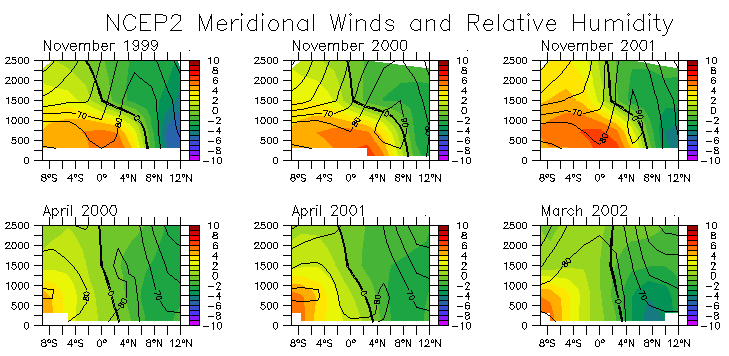
3.2.2 Is background moisture off?
Check moisture sounding of worst comparison -- NCEP2.
Fig. 5. Look at NCEP2 soundings versus observed soundings.
This needs to be redone using specific humidity rather than
relative humidity.
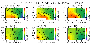
Comments about NCEP2 sections vs. soundings
NCEP2 spring sections don't have double ITCZ.
| |
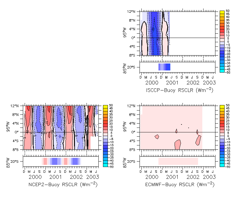
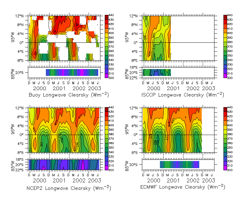
3.2.3 Is clearsky off?
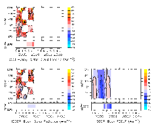
Fig. 6.
Left figure: Solar clearsky from buoys, NCEP2, ISCCP and ECMWF.
Middle figure: The difference between NCEP2, ISCCP, and ECMWF solar
clearsky and buoy solar clersky (RSCLR).
|
|
Comments about TAO solar clearsky
Sunnier clearskies during fall equinox than spring equinox.
This is a bit odd,
since earth is closer to sun during March than September. Must be due
to the seasonality of a) aerosol absorption coefs, and/of
b) integrated water vapor. These were parameterized by Chris Fairall.
Southern hemisphere has sunnier clearskies than northern hemisphere.
Again, this is built in by C. Fairall parameterization of k1, k2, watvap, oz.
Largest range of clearsky solar radiation is at 20S, as expected.
latitudinal dependence on watvap is built into Fairall parameterization:
bf = 3.5+2*(10-lat)/20 =q/watvap for latitudes between 10S and 12n in the
solar clearsky formula.
Comments about NCEP2 solar clearsky
Seasonality is more symmetric than buoy.
Difference from buoy has a +/- 10 W/m2 seasonal cycle.
Comments about ISCCP solar clearsky
Unlike buoys, clearskies in NH are stronger during spring equinox than fall equinox.
Comments on ECMWF solar clearsky
watvap, k1, k2, oz are computed using the Fairall algorithm. I could
use the watvap provided by ECMWF, although I don't have this variable for
the 85W, 20S site. I believe this is a minor effect and may change values
by ~ 3 W/m2. It may provide a small seasonality effect. I can pursue this,
but would prefer to do this only if I have it for stratus site as well.
Kelan is checking.
Matches buoys better than NCEP2 does. (as expected since ECWMF and
buoys used same formula for clearsky).
|
|
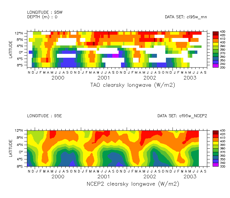
Fig. 7.
Left figure: Longwave clearsky from buoys, NCEP2, ISCCP and ECMWF.
Middle figure: The difference between NCEP2, ISCCP, and ECMWF solar
clearsky and buoy longwave clearsky (RLCLR).
All CFRL fields are pretty similar.
latitudinal dependence built into the Fairall ir clearsky formula.
latitudinal dependence of moisture.
Diagnosing the differences (cont.):
The above results (Fig 5-6) show that clearsky differences are not the primary
source of error in the cloud forcing.
3.3 Making the Best Better.
ISCCP is best. ISCCP radiation should be used instead
of ECMWF or NCEP2 if possible. But there are offsets in ISCCP solar
radiation. How can it be made better?
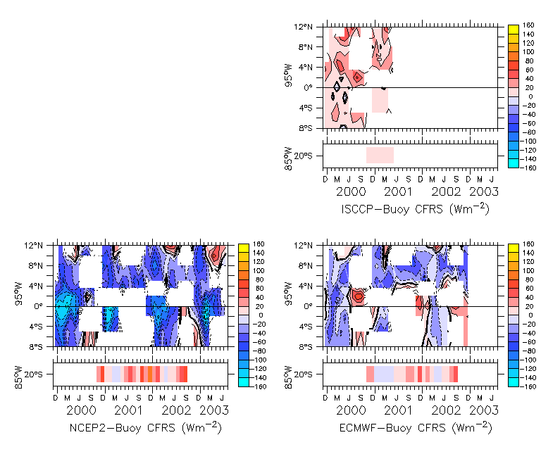
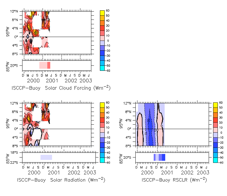
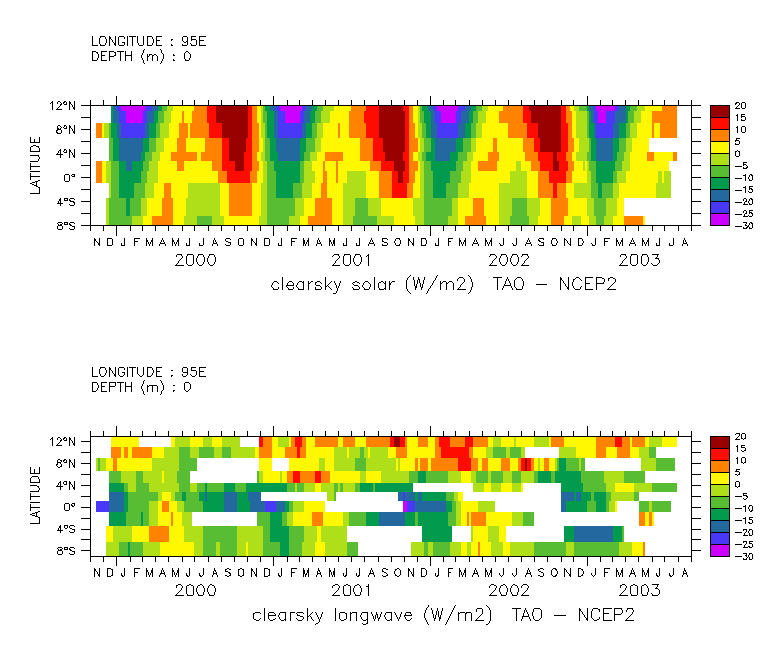
Fig. 8. Understanding and modelling ISCCP Solar Radiation "error".
Left: ISCCP-Buoy CFRS components. CFRS = Rs - Rsclr.
Right: Modelling ISCCP-Buoy Rs.
What is source of ISCCP CFRS error? n.b. CFRS = Rs - Rsclr
The "error" in ISCCP solar cloud forcing (top left panel) is primarily
due to error in downwelling solar radiation at the surface (bottome left
panel).
although, clearsky solar radiation discrepency (bottom right panel)
contributes.
It is unclear to me if the discrepency in clearsky radiation (RSCLR)
is due to ISCCP, or the Fairall algorithm used for the buoy. Either way,
it is likely due to different treatment of aerosol seasonal cycle.
ISCCP solar radiation appears to be too strong.
What should ocean modelers do?
|
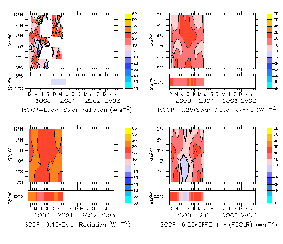
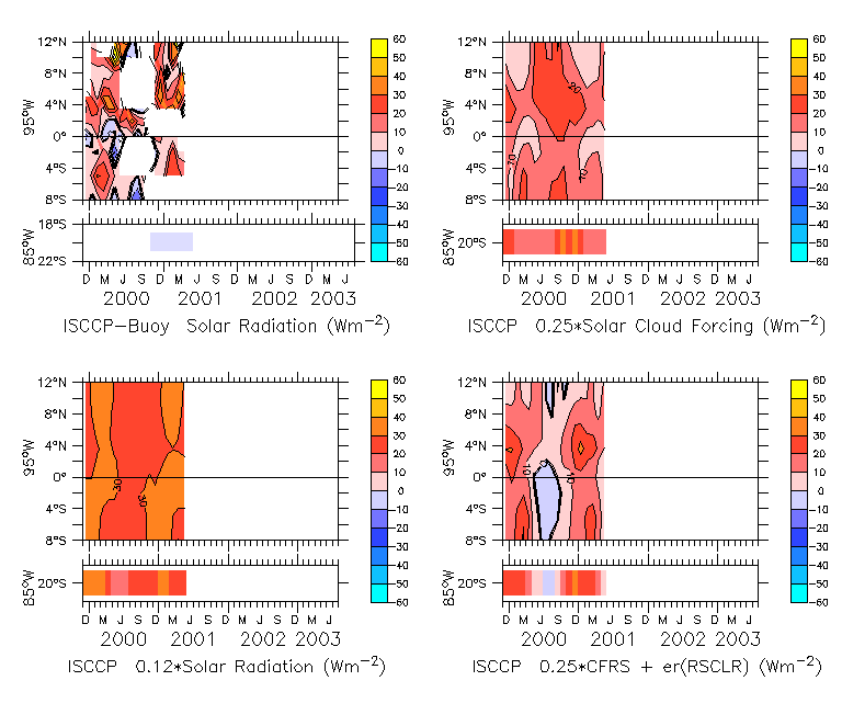
How best to model the error in ISCCP's downwelling solar radiation: true Rs = Rs - er(Rs), (where er(Rs) is shown in top left panel above)?
Scale the Solar radiation by some factor: Rs true ~ .88 Rs.
bottom left panel: er(Rs) = 0.12 * Rs . Does bottom left panel match top left?
Add a scale factor of the cloud forcing: Rs true ~ Rs + 0.25*CFRS
top right panel: er(Rs) = -0.25 * CFRS . Does this look like top right panel?
Add a scale factor of the cloud forcing and a season cycle
associated with clearsky variation: Rs true ~ Rs - f(CFRS,er(RSCLR))
er(Rs) = -0.25*CFRS + (15 W/m2*cos(2pi*(t-march)/12) -7 W/m2).
(bottom right panel).
|
4. Discussion and Conclusions
The end.
|
TODO?
Update stratus buoy & ECMWF time series to include
oct 2002-oct 2003 deployment.
Investigate net cloud forcing properties & SST relation? e.g.
scatter plots similar to Fig 4, but for net CFRL vs. net CFRS. ?
This should be almost identical --
I would prefer not to deal with net cloud forcing for ISCCP,
NCEP2 & ECMWF. Perhaps I can finesse discussion of (1-alpha) CFRS vs. epsillon
CFRL. or do a set of (black&white)
figures similar to Fig 4 but only with buoy net cloud forcing estimates.
Presumably, the errors in net cloud forcing are similar to downwelling.
The purpose of this would be to better understand physics of
cloud forcing on SST.
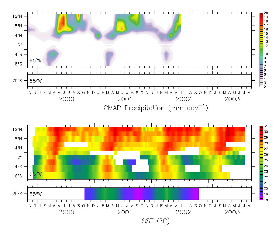
Show rain & SST time series ? (this figure has CMAP, but
I can now redo with TRMM). I'm a little bit worried about getting
too much into rainfall, since this is a whole other topic.
Should we develop a function for CFrl = function(CFrs,y)?
Chris says no need. I agree. Although, it might be a nice product
from this paper. Nick says functional form is CFrl = function(CFrs,y,Ts) or
function(CFrs,y,Ts-Ta)... Also can show latitudinal variations in
range of solar cloud forcing.
|
|
More figures.
Diagnostics of TAO - NCEP2 comparison...
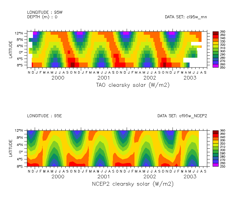
Fig. 5. TAO vs. NCEP2 solar and longwave clearsky. Left: TAO (top)
and NCEP2 (bottom) solar clearsky.
Are the top
and bottom the same???? I don't think so...
QUESTION: Why should NCEP2 solar clearsky differ from observed? Hm... isn't
the earth closer to the sun in February than in August? I guess, the
NCEP2 looks more reasonable in this respect. ???
Return to Meghan
Cronin's Home Page
Return to TAO/EPIC Home Page
Privacy Policy and
Disclaimer