[Thread Prev][Thread Next][Index]
Re: Re: [ferret_users] Orthographic projection - variable from 1-degree model
- To: "ferret_users@xxxxxxxx" <ferret_users@xxxxxxxx>, "Ansley C. Manke" <ansley.b.manke@xxxxxxxx>
- Subject: Re: Re: [ferret_users] Orthographic projection - variable from 1-degree model
- From: niciej <niciej@xxxxxxx>
- Date: Wed, 20 Jun 2018 12:56:06 +0200
- Arc-authentication-results: i=4; mx.google.com; dkim=pass (test mode) header.i=@onet.eu header.s=2011 header.b=I2AJE4df; arc=pass (i=2 dkim=pass dkdomain=onet.eu); spf=fail (google.com: domain of niciej@xxxxxxx does not designate 52.222.5.176 as permitted sender) smtp.mailfrom=niciej@xxxxxxx
- Arc-authentication-results: i=3; mx.google.com; dkim=pass (test mode) header.i=@onet.eu header.s=2011 header.b=I2AJE4df; arc=pass (i=2 dkim=pass dkdomain=onet.eu); spf=fail (google.com: domain of niciej@xxxxxxx does not designate 52.222.5.176 as permitted sender) smtp.mailfrom=niciej@xxxxxxx
- Arc-authentication-results: i=2; mx.google.com; dkim=pass (test mode) header.i=@onet.eu header.s=2011 header.b=I2AJE4df; arc=pass (i=1 spf=pass spfdomain=onet.eu dkim=pass dkdomain=onet.eu); spf=fail (google.com: domain of niciej@xxxxxxx does not designate 65.127.216.227 as permitted sender) smtp.mailfrom=niciej@xxxxxxx
- Arc-authentication-results: i=1; mx.google.com; dkim=pass (test mode) header.i=@onet.eu header.s=2011 header.b=I2AJE4df; spf=pass (google.com: domain of niciej@xxxxxxx designates 141.105.16.29 as permitted sender) smtp.mailfrom=niciej@xxxxxxx
- Arc-message-signature: i=4; a=rsa-sha256; c=relaxed/relaxed; d=google.com; s=arc-20160816; h=list-archive:list-help:list-post:list-id:mailing-list:precedence :message-id:subject:date:to:from:mime-version :arc-authentication-results:arc-message-signature :arc-authentication-results:arc-message-signature :arc-authentication-results:arc-message-signature:sender :dkim-signature:arc-authentication-results; bh=g+615VGZBmAU06jXs601H+LFgHwLQHDVuEv/UZbCjBM=; b=VYtvZNX5sFgIj48hGVeKAdE5DbMjuknKwyCOzTqHI6lLlfnbCwufgMGVyqi5e0s/GM qQrE/CEtw+lL96BAeQyabiMgCl6thWmWwOpMz6me1C3kGUSGPBl27NQ1on3WhWe0qjpv 0fIcUBhp1daX8itREDwUM0SrDSDV8zHlPdUXLQimYQuwkqQvhHUuPSwLemkc77gFxyJ1 d2nV5FiEFmuwhYDj0ouiAZxE4joYA6obtd2XM/s7umwnX/MO+P6SwsPLuxHWW5IOaRGi FAqvRr5tzbAI9X3UqhP8/VdGqDyQb0amJno4hjkAyTmBse0pRwtmoINbraKPexsfMOYd D/Sw==
- Arc-message-signature: i=3; a=rsa-sha256; c=relaxed/relaxed; d=google.com; s=arc-20160816; h=message-id:subject:date:to:from:mime-version:dkim-signature :arc-authentication-results:arc-message-signature :arc-authentication-results:arc-message-signature :arc-authentication-results; bh=g+615VGZBmAU06jXs601H+LFgHwLQHDVuEv/UZbCjBM=; b=coMnJkLyP+KMPrfAwROqAgVd5Dn4oGbqdepNzCc2yyziby2H/GVCdpB93frWN0d/WC RVQWqnBNZiF2fYpQguYEVvjxDhn1YZ4s0KwTDmiqzPTCfaOfMdXUi6Rww+7EkD2GPgxM 1p+hGZhrlZpxQ6kl0DJDAieX+pOSBXobsB703wcN7ZI2SrVgm8+9sMXHTurVf65Y64nn gE1l2E5uEbn6Db6ZsUOjC6kH7HmilY48vMwCJ6HXKibapc2sVD+oewxhJwi2lbEFtSx/ 4RDdJpa09gEP6xG7zg7p7LLGVqkiAY/Ood1JKcQSxxPsIqwBczgl7oNDb+k6AEqJTDaW 6HRQ==
- Arc-message-signature: i=2; a=rsa-sha256; c=relaxed/relaxed; d=google.com; s=arc-20160816; h=subject:message-id:date:to:from:mime-version:dkim-signature :arc-authentication-results:arc-message-signature :arc-authentication-results; bh=g+615VGZBmAU06jXs601H+LFgHwLQHDVuEv/UZbCjBM=; b=L11CZJUdvxoV2hiEl078+PlAF9dGXFf7hIfc7pXMi/gacwse1VpG29ltHHlgZ2MdnN KQubRb5c0X7FJ+zNdAcY7YUkLsbvqaZwnEpu+oAGBd2djXt1XiLlJe7fYElR+DOewqJu +/jL/OwkMKFJHWwAh5QiqqmIrGAGz0KSG4V0krbA78+2W7s98misoiebeXdForPJG8IY PMBTgwf5tjc8SdNgv9fd1TT4bUBAd0rPclP24a4+qGakD4+k7sm49z7sgs6htA+c026E AgOyb6LmVbJaVhFO7Ckf25vohESPyA5/BAuc3bOr3qXKgf2zNxcpop38LCRap5ZT/q// QmbA==
- Arc-message-signature: i=1; a=rsa-sha256; c=relaxed/relaxed; d=google.com; s=arc-20160816; h=subject:message-id:date:to:from:mime-version:dkim-signature :arc-authentication-results; bh=g+615VGZBmAU06jXs601H+LFgHwLQHDVuEv/UZbCjBM=; b=tN4fBYuEFtvcpQQfBOvoV4Rvo2Aa2FhVjp0ht5+fG+dhg3lW7nwl/FxM8YkgM++7W9 KwG9wnej166EnfWnvbk6jbEeOsgaj4LmdeaVUcl6ycuWtF+T3V83b/vhCTLszr0S7K4g sRBnKQ0PdgGj3NJW+7kzEfcQttulnXNhG8cqrzmxPhfDU2ID2hA2yoyYb1gPPCwkF0Ld ddgBIktduoN5CyiJUHFHr+2lFYy/Uyl8mmU15FifC/SqyUK4VOIa6XtywacbL3wc2QmM A+Rbv1FwQhUYTi6gSpMf+YwnV6juAVC3ZqpPsH6WCWKZVkQJHrcD7AYqA6xHUV3t6UjB 06GA==
- Arc-seal: i=4; a=rsa-sha256; t=1529492229; cv=pass; d=google.com; s=arc-20160816; b=rtlqGcVULJNkAJa62Z2roPtuh9GR99+ZPims+Vy31jGkQZkxqXrzaz1Q0f9Xcav9R3 gHGAtJr/B04D1pJ9XMIaEW1DVsZKuj7bb/mW9X23kh6SN41/6ik9tseXH6bK3qwd3Ic4 ep9/YDT/VFcX+QsDEEdziGvyR+rgHXg6mpYm8CiNKq5d5K8K4OzCYvDxOBpCzsSV4vjp iyl+Yiq5I0p3SlTXnmFVpc8LmbjKazll+euIGZw2o20ghQ8dWMmjWoRx3TPisdYBXd5B FzhRSeD/VXxsKdw3iRyHUfdLdDTCSWi+JgeCRmixkuJfBre3M4b4tZIUpQquWpP4Ybcn Zokg==
- Arc-seal: i=3; a=rsa-sha256; t=1529492226; cv=pass; d=google.com; s=arc-20160816; b=mOPZ8Yn1djb6sHrxTom6S5TMTBMpzhxMrDGeKQFEQxmQxmWPGnXJk2N3FnJaCD8BMz W4rgKvNVlfuZnKf4Ezwk41tyHp5i7sqNVF83UWuOLHm7Tf0LVlLKIG+J4fase9mBwytx HKXb39RJr5MexxEy4fJq02nlUinnry2tdUy3XZEPVQaT/km1hav296tflnw2ssEBWRPc PxkcDz07bUHRO1ESO9f4I9G23FZU0haEoUtbfkNIvdw20FDBLIRxHaT2x1BiTbEDQNNJ hz+MPDIXs87fwj9zhL3H9nhln7EK9EC0lOAs46Flnuk9TI+Esp02U+8g77/Y6oLmwpUP oAFw==
- Arc-seal: i=2; a=rsa-sha256; t=1529492193; cv=pass; d=google.com; s=arc-20160816; b=uodg5tuYxraUri2wm5vohk7l9+ztaY+xeIbRx0ySPbb3BPk5TgVWkvV5QIFJFAEVMv SVvD8YUqo/GhjGdVA+wyZaidl0tATxzfFwOjKT1FAFOfXIRvw38yddIskxpQ7HsD1bRt xeolEw53cZChnIXSfPx6nUVSXbLJbkJ7zhJ13ISEAI72fldG8E5NhAP9ITQ2/pKmpTzN v0fqibNyifQnkQrBg+tYz37HygESCuEYkXD6dDoKg5vMRKcP4+rhiVTTuc9B3VWu5LlN AttyESluStA3BHI93bq4mUsp2BgclS/AJ117QA5yOwpWcrnzhM1Yj3In0tyPBUQk9Ccu lgdQ==
- Arc-seal: i=1; a=rsa-sha256; t=1529492178; cv=none; d=google.com; s=arc-20160816; b=JlQyYOTLMfVqIDuDTH4fgWSClRAmXd3MR7qCVTwNJf7aDa5yCgcPltXrti7R43nSrP kAibQcsRM/7y42jwnTJTr1qA72zF+Ei2hPflOQJk72PBLm1kMvGfhDr2BkTQQntNp5PU 4quJxChcNDPT9B0zVNUOvGrRdNFPQvurL4x0YjZbDrpSvXo/KRRyQatZet0oqEmUrEhC 4mznXtHDcK5r75AHYoEaQ2HoO3Q3ScoKbDjfhmGqDevTfp8CD9a4BV7E6gSGr2wfkDm5 8BuKz0Og96sk1PkNQVEzQ+QkXTTazUjhKW3hw3l35gpcQQ0elG6gupzYkZEZlGK4CFjH vMdQ==
- Dkim-signature: v=1; a=rsa-sha256; c=relaxed/relaxed; d=noaa.gov; s=google; h=sender:mime-version:from:to:date:subject:message-id :x-original-sender:x-original-authentication-results:precedence :mailing-list:list-id:list-post:list-help:list-archive; bh=g+615VGZBmAU06jXs601H+LFgHwLQHDVuEv/UZbCjBM=; b=O2R2Q6kj/aABKiUzBHlSToQ/USRXyf7ILc+TySJsQ7v2y8bCUryhxyzoThY1L4TbM3 mUVp0yk4WFOxi1u3KErI20zV4I6m325MU83V/FA41Y8SINwD7DTcLMzyMBKCZOxxlJY9 YQ9LuZ82bB+wH/xJjgzwxTeQ321IdctGIww1jExcCl1RbgOQXlEoxxU5OTdPnFe3obXp w5cXGHtjFmwr32yn8tmwl1ulvudvlkCvPIni9zeR7UznL+kl9uDW/nXy9zLLNxHxmMza lneoCSforDpDLGhCIo/a0Hpd4WHnmAlSYPAGwcI6e0dmVTZF0WWxNy7X4sIvxGJxHTpv mHaQ==
- List-archive: <https://groups.google.com/a/noaa.gov/group/ferret_users/>
- List-help: <https://support.google.com/a/noaa.gov/bin/topic.py?topic=25838>, <mailto:ferret_users+help@noaa.gov>
- List-id: <ferret_users.noaa.gov>
- List-post: <https://groups.google.com/a/noaa.gov/group/ferret_users/post>, <mailto:ferret_users@noaa.gov>
- Mailing-list: list ferret_users@xxxxxxxx; contact ferret_users+owners@xxxxxxxx
- Sender: owner-ferret_users@xxxxxxxx
I'm really sorry for the confusion - test.nc file is actually incomplete - as Ansley noticed, it was cut out from a larger file (which was too big to attach).
I'm attaching a similiar file now (test1.nc) - this one is original file from Los Alamos Sea Ice Model (CICE), with nominal 1 deg grid, without any cuts (so with longitude and latitude coordinate data)
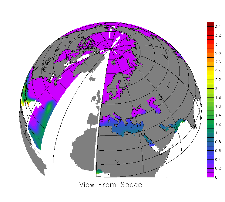
The problem with orthographic projection can be presented with HI (ice thickness) variable
So once again:
use test1.nc
SET REGION/X=0:360/Y=-90:90/L=1
GO mp_orthographic 10 45
SET GRID hi
GO mp_aspect
LET masked_hi = hi * mp_mask
FILL/NOAX/NOLAB masked_hi, x_page, y_page
LABEL/NOUSER `($PPL$XLEN)*0.5`,-0.4,0,0,0.2 View From Space
GO mp_fland
GO mp_land
GO mp_graticule
And the result is (incorrect as previously) on PIC2.
Ansley C. Manke <ansley.b.manke@xxxxxxxx> wrote:
> Hi,
>
> This looks to me as if it may be an incomplete file, which should have
> separate variables containing longitude and latitude coordinate data.
> Did you write out test.nc from a larger file? If so, did the original
> file have 2-D variables, on the same grid as SSH, with units of
> longitude and latitude? If so, see the documentation about "curvilimear
> coordinates".
>
> If your data is on a curvilinear grid, it can be plotted using a map
> projection. See this FAQ:
>
> https://ferret.pmel.noaa.gov/Ferret/faq/curvilinear-data-in-map-projections
>
> Ansley
>
>
> On 6/19/2018 6:20 AM, niciej wrote:
> > Dear Ferreters,
> > I have a data set(test.nc) with SSH variable from 1-degree model.
> > Basic Ferret plot of SSH is shown on PIC1
> > I'm trying to plot it using orthographic projection:
> >
> > use test.nc
> >
> > SET REGION/X=0:360/Y=-90:90/L=1
> >
> > GO mp_orthographic 10 45
> >
> > SET GRID ssh
> >
> > GO mp_aspect
> >
> > LET masked_ssh = ssh * mp_mask
> >
> > FILL/NOAX/NOLAB masked_ssh, x_page, y_page
> >
> > LABEL/NOUSER `($PPL$XLEN)*0.5`,-0.4,0,0,0.2 View From Space
> >
> > GO mp_fland
> >
> > GO mp_land
> >
> > GO mp_graticule
> >
> > My results are shown on PIC2 - the projection is incorrect, moreover
> > there is a gap between 320 - 360 deg.
> > How can I get a correct projection?
> > Thanks a lot,
> > Jan Niciejewski
> > Institute of Oceanology PAS
>
>
Attachment:
test1.nc.gz
Description: GNU Zip compressed data
Attachment:
PIC2.png
Description: PNG image
[Thread Prev][Thread Next][Index]
Contact Us
Dept of Commerce /
NOAA /
OAR /
PMEL /
Ferret
Privacy Policy | Disclaimer | Accessibility Statement