PMEL Home Page FOCI Home Page


CRUISE REPORT
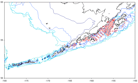
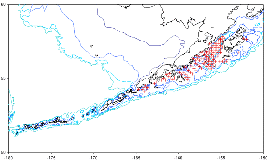
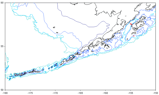
Cruise Number: MF00-08
FOCI Number: 6MF00

Ship: NOAA Ship Miller Freeman

Area of Operations:

Gulf of Alaska
Itinerary:
Date depart / port:May 25, 2000 / Dutch Harbor, AK
Date arrive / port:June 4, 2000 / Kodiak, AK
Participating organizations:
NOAA - Alaska Fisheries Science Center (AFSC)
Chief Scientist:
Kevin BaileyM / AFSC
(206) 526-4243
Kevin.Bailey@noaa.gov
Personnel:
Debbie BloodF / AFSC
Annette BrownF / AFSC
Rachael CartwrightF / AFSC
Susan PicquelleF / AFSC
Steve PorterM / AFSC
Cruise Objectives:
1. To deploy 2 satellite tracked drifters in the Bering Sea
2. To conduct an ichthyoplankton survey from Unimak Pass to and around Kodiak Island
3. To conduct nearshore sampling of ichthyoplankton using a small vessel deployed from the Freeman
4. To conduct miscellaneous sampling as per requests from other NOAA scientists
Summary of Operations:
OperationTows
20cm bongo (20Bon)5
60cm bongo (60Bon)142
Aleutian wing trawl (Aleutian)1
CalCOFI vertical egg tow net (CalVET)5
Seabird SeaCAT CTD (CAT)140
CTD with bottle samples (CTDB)4
Eastern or 83-112 trawl (Eastern)2
Vertical 60cm bongo tow with taped codends (Live) 2
Methot trawl (Meth)3
Deployment of satellite buoy (SatBuoy)5
Samples CollectedTowsNumber
SeaBird SeaCat CTD (CAT)139
Extracted chlorophyll (Chlor)318
SeaBird CTD (CTD)5
Deployment of buoy or mooring (Deploy)55
Stimulated fluorescence collected during CTD casts (Fluor)4
Juvenile pollock collected for otolith analysis (J-Oto) 2217
Larval pollock collected for histological analysis (L-Hist) 22295
Larval pollock collected for otolith analysis (L-Oto) 1314433
Collection of live organisms for experiments (Live) 2
Nutrient samples collected from CTD casts (Nut) 332
Photosynthetically Active Radiation (PAR) data collected during CTD casts 4
Quantitative tow preserved in formalin (QTowF) 153179
Rouch count of pollock larvae (RCountL)1348060
Summary of Cruise:

Narrative:

The ship disembarked Dutch Harbor on May 25 as per schedule. A short way out of Dutch 2 satellite-tracked drifters were deployed in the Bering Sea according to a request from PMEL scientists (Figure 2). Between Unimak Pass and the Shumagin Islands approximately 20 icthyoplankton stations were sampled with bongo tows (Figure 3).

The regular FOCI grid of stations was occupied from the Shumagin Islands to Kodiak Island. Approximately 120 stations were occupied. Three satellite-tracked drifters were deployed in the vicinity of high concentrations of pollock larvae. At the termination of the grid, line 8 was sampled with CTDs (Figure 4), 20/60 cm bongo tows and Calvet. The Calvet was utilized for sampling microzooplankton instead of bottle casts because water sample filtering devices were not available. Several line 8 stations were eliminated due to time constraints and due to a rupture of the hydraulic line on the port-side oceanographic winch.

The Munson was deployed outside of Wide Bay for the nearshore sampling. Two bongo tows were taken inside Wide Bay. This work is still in the experimental phase to determine the feasibility of obtaining quality samples from a small boat.

Several bottom trawls and an Aleutian Wing midwater Trawl were conducted to obtain samples requested by NOAA scientists. Three exploratory Methot trawl samples were collected for Atka mackerel juveniles by rigging the net frame to sample neustonically (Figure 5). Finally, several bongo stations were occupied on the outside of Kodiak Island and in Chignik Bay.

Overall, the cruise was quite successful and no days were lost due to weather.

Days Lost to Weather:
None
Days Lost to Equipment Failure:
None
Recommendations:
None
Acknowledgments:
The scientific party would like to acknowledge the hard work and support of the officers and crew of the Miller Freeman.
Attachments:
Table 1. Cruise Summary (PDF file)

Figure 1. Station Map

MF00-08 station map
 

Figure 2. Locations of satellite-tracked drifter deployments

MF00-08 drifter map


Figure 3. Locations of bongo tows.

MF00-08 bongo map
 

Figure 4. Locations of CTD casts.

MF00-08 CTD map
 

Figure 5. Locations of Methot tows.

MF00-08 Methot map

Fisheries-Oceanography Coordinated Investigations

NOAA | Pacific Marine Environmental Laboratory | Alaska Fisheries Science Center

Seattle, WA 98115
FOCI Coordinator
Disclaimer | Privacy Policy