|
Date: 13 June 2000
CRUISE REPORT
NOAA Ship: MILLER FREEMAN
Cruise: MF00-07 (Greenbelt Study)
Area:
Southeastern Bering Sea
Itinerary:
14 May Depart Dutch Harbor
22 May Arrive Dutch Harbor
Participating organizations:
NOAA - Alaska Fisheries Science Center (AFSC)
NOAA - Pacific Marine Environmental Laboratory (PMEL)
CRUISE OBJECTIVES:
Mesopelagic fishes and squids are critical components in the diet of apex predators (marine mammals, birds, and semi-demersal fishes) in the southeastern Bering Sea. This is the second year of a pilot study designed to identify mesopelagic fishes and squids, their habitat, and the physical mechanisms that define that habitat in the southeastern Bering Sea Green Belt. Three sampling strategies were used: 1) midwater tows day and night at three depths to sample mesopelagic fishes and cephalopods; 2) CTD deployment at fishing stations and along standard tracklines to measure current flow, water temperature, salinity, and chlorophyll; and 3) flying bridge observations of marine mammals when the ship was underway between stations.
1.0. PERSONNEL
1.1. Chief Scientist:
Beth Sinclair NOAA/NMML telephone: (206) 526-6466
e-mail: beth.sinclair@noaa.gov
1.2 Participating Scientists:
Name Sex Affiliation
Dennis Benjamin M NOAA/RACE
Kate Call F NOAA/NMML
Carolyn Kurle F NOAA/NMML
Beth Sinclair F NOAA/NMML
Sigrid Salo F NOAA/PMEL
Tonya Zeppelin F NOAA/NMML
1.3 NOAA Pacific Marine Center Operations Contact:
Larry Mordock
NOAA/PMC (PMC1x4)
1801 Fairview Ave. East
Seattle, WA 98102-3767
(206) 553 - 4764
Larry.Mordock@noaa.gov
1.4 Program Contacts:
Dr. Phyllis Stabeno (PMEL)
Dr. Art Kendall (AFSC) (206) 526-4108
7600 Sand Point Way
Seattle, WA 98115
Phyllis.Stabeno@noaa.gov (206) 526-6453
CRUISE DESCRIPTION:
2.0. OPERATIONS
SUMMARY OF ACTIVITIES:
A). Examine distribution and relative biomass of the midwater prey community in areas of historically high bycatch.
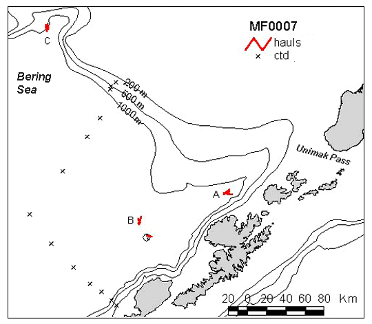
The midwater zone was sampled with an Aleutian Wing Midwater Trawl into which a 20m, 1/2" (stretched mesh) codend liner had been inserted prior to ship departure from Dutch Harbor. Trawls were conducted as a diel series at three depths (250m; 500m; 1000m) in three subareas. A trendline CTD track was run and CTDs were conducted at the equilibrium location for each trawl, or in some cases every other trawl within each region (Fig. 1, Table 1). Trawls were dropped obliquely to depth (250m, 500m, and 1000m), with one hour trawl time at depth at a vessel speed of 3kts. Trawling duration was reduced from one hour to 30min at the 1000m meter depth in order to maximize the number of trawls conducted throughout the cruise. Vessel speeds were increased up to 4.0 kts during net deployment and retrieval to reduce bycatch from non-target depths. Exact trawl locations were adjusted somewhat from the original study plan in order to take advantage of changing conditions such as wind direction. Otherwise, two to three days were spent in each subarea allowing for 4-6 trawls (i.e. two daylight, two nighttime) at each depth in each area. A total of 31 trawls and 29 CTDs were conducted throughout the cruise. (Table 1, Fig. 1).
B) Examine distribution and feeding activity of marine mammal predators in areas of historically low and high marine mammal densities.
Marine mammal surveys were conducted during daylight hours from the flying bridge when the vessel was underway (during midwater trawl operations and between CTD stations when time allowed). Observations were conducted by one observer covering a 45 degree area port and starboard of the bow.
C). Examine the physical mechanisms influencing the distribution of the midwater nekton community and their predators.
CTD readings were collected along two transect lines to 1500m (or to the bottom), and at the equilibrium point of each trawl or two depth series of trawls (Fig. 1, Table 1). Flourometer measurements were taken along the same tracklines as CTDs, but the flourometer was removed for casts deeper than 500m. The shipboard Seachest Flourometer was running throughout the cruise. A series of satellite-tracked drifters were dropped near station "A" prior to the start of this cruise.
A standard oceanographic watch was utilized which consisted of a winch operator, a scientific staff of three to five, and a survey tech on deck. Operations were conducted 24 hours a day. A fishing crew assisted with midwater trawls. A survey tech and winch operator were available for CTD operations.
PROCEDURES FOR OPERATIONS:
The following operations were conducted on this cruise. The procedures for these operations are listed in the FOCI Standard Operating Instructions (SOI). Operations not addressed in the SOI and changes to standard procedures are addressed below.
CTD/Water samples (SOI 2.2.1)
Midwater trawl (SOI 2.2.8)
EK500 monitoring (SOI 2.2.12)
Seachest and Uncontaminated Seawater (SOI 3.4)
3.0. FACILITIES AND EQUIPMENT
The following systems and their associated support services were essential to the cruise. Sufficient consumables, back-up units, and on-site spares and technical support were in place to assure that operational interruptions were minimal. All measurement instruments had current calibrations, and all pertinent calibration information were included in the data package.
3.1 Equipment and Capabilities Provided by the Ship
Oceanographic winch with slip rings and 3-conductor cable terminated for CTD,
Wire-angle indicator and readout for oceanographic winch,
Oceanographic winch for bongo net (and other nets when used) with slip rings and 3-conductor cable terminated for the SeaCat,
Sea-Bird 911 plus CTD system to be used with PMEL stand (primary system)
(The underwater CTD unit should have mounts compatible with the PMEL CTD stand),
Sea-Bird 911 plus CTD system with stand (back up system),
Sea-Bird SBE-19 SeaCat system (primary system)
(Each CTD system should include underwater CTD, weights, and pinger and there should be one deck unit and tape recorder for the two systems),
10-liter sampling bottles for use with rosette (10 plus 4 spares),
For CTD field corrections: IAPSO water and AUTOSAL salinometer,
Wire speed indicators and readout for quarterdeck, Rowe and Marco winches,
For meteorological observations: 2 anemometers (one R. M. Young system interfaced to the SCS), calibrated air thermometer (wet-and dry-bulb) and a calibrated barometer and/or barograph,
Freezer space for storage of biological and chemical samples (blast and storage freezers),
Simrad EQ-50 echo sounder,
JRC JFV-200R color sounder recorder,
RDI ADCP written to SCS and Iomega Zip drives,
Bench space in DataPlot for PCS, monitor, printer and VCR to fly MOCNESS,
Use of Pentium PC in DataPlot for data analysis,
SCS (Shipboard Computer System),
Aft Rowe winch,
Electrical connection between Rowe winch and DataPlot,
Laboratory space with exhaust hood, sink, lab tables and storage space,
Sea-water hoses and nozzles to wash nets (quarterdeck and aft deck),
Adequate deck lighting for night-time operations,
Navigational equipment including GPS and radar,
Safety harnesses for working on quarterdeck and fantail,
NOTE: Stern platform was removed and stored prior to departure.
3.2 Equipment to be Provided by the Project
PMEL PC with SeaCat and SEASOFT software for CTD data collection and processing,
Fluorometer to be mounted on CTD,
CTD stand modified for attachment of fluorometer,
Conductivity and temperature sensor package to provide dual sensors on the primary CT, and one for the backup system,
CTD rosette sampler,
WestMar (third wire),
Two MBTs (bathythermographs),
Two Aleutian Wing Midwater Trawls (AWT),
Two AWT codend liners (1/2" stretch)
Fishbuster doors (2750 lbs)
Argos tracked drifter buoys with optical sensors,
EK500 monitoring system,
Miscellaneous scientific sampling and processing equipment,
Sorting tables and baskets for processing trawl catches,
Discrete Sample DataBase forms
3.3. Ship's Computer System (SCS)
The ship's Scientific Computer System (SCS) operated throughout the cruise, acquiring and logging data from navigation, meteorological, oceanographic, and fisheries sensors. See FOCI Standard Operating Instructions for specific requirements. The ship uses the NT version of SCS. The VAX is only available for data processing. An upgraded version of the NT SCS software was provided. Contact CST Wm. Floering for further information.
4.0 DATA AND REPORTS
Data disposition, responsibilities and data requirements are listed in the FOCI Standard Operating Instructions.
5.0 ADDITIONAL INVESTIGATIONS AND PROJECTS
5.3 Piggyback projects:
There were no formal piggyback projects however, squid and fish samples were collected informally for researchers and institutions unassociated with this study.
6.0 MISCELLANEOUS
6.5. Hazardous Materials:
The Chief Scientist shall be responsible for complying with NC Instruction 6280A, Hazardous Waste; policy, guidance, and training, dated February 4, 1991, paragraph 7.g and paragraph 9. By federal law, the ship may not sail without a complete inventory of MSDS, and appropriate neutralizing agents, buffers, and/or absorbents in amounts adequate to address spills of a size equal to the amount aboard.
The following hazardous materials were provided and controlled by the scientists with the Chief Scientist assuming responsibility for the safe handling of such substances:
Hazardous Materials:
Buffered Formalin
Isopropyl Alcohol
Additions to FOCI/AFSC chemical manifest -- none
7.0 COMMUNICATIONS
7.4 Important phone numbers, fax numbers and e-mail addresses:
PMEL/CARD Fax: (206) 526-6485
PMEL/ADMIN Fax: (206) 526-6815
AFSC/RACE Fax: (206) 526-6723
MILLER FREEMAN COMSAT (government account numbers): These are much cheaper than INMARSAT direct numbers and should always be used first.
800-678-0872, after tone dial customer ID# (Voice)
800-678-0872, after tone dial customer ID# (Fax)
PI's should establish their ID#'s with their program.
INMARSAT (direct numbers)
INMARSAT B voice: 011-872-330-394-113
INMARSAT B fax: 011-872-330-394-114
INMARSAT M voice:011-872-761-267-346 (or 347)
INMARSAT M fax: 011-872-761-267-348
CELLULAR: 206-660-7167
KODIAK ROAMER: 907-528-7626
DUTCH HARBOR ROAMER: 907-391-7626
(First dial the roamer, wait for dial tone, and then dial cellular number.)
8.0. APPENDICES
Table 1. -- CTD trackline location data.
|
Activity
|
N Latitude
|
W Longitude
|
Cast
depth
(m)
|
Water
depth
(m)
|
Distance
(nm)
|
Transit
time
(hrs)
|
Station
time
(hrs)
|
Cumulative
time
(days)
|
|
Dutch
Harbor |
53
|
54.5
|
166
|
30.9
|
|
|
|
|
|
|
|
CTD
|
53
|
22.0
|
168
|
42.0
|
500.
|
500.
|
84.23
|
8.67
|
0.66
|
0.39
|
|
CTD
|
53
|
25.5
|
168
|
46.0
|
1000.
|
1000.
|
4.23
|
0.67
|
1.03
|
0.46
|
|
CTD
|
53
|
31.0
|
168
|
55.0
|
1500.
|
1850.
|
7.69
|
1.02
|
1.40
|
0.56
|
|
CTD
|
53
|
36.0
|
169
|
4.0
|
1500.
|
1875.
|
7.31
|
0.98
|
1.40
|
0.66
|
|
CTD
|
53
|
47.0
|
169
|
16.0
|
1500.
|
1575.
|
13.08
|
1.56
|
1.40
|
0.78
|
|
CTD
|
54
|
2.0
|
169
|
34.0
|
1500.
|
1842.
|
18.37
|
2.09
|
1.40
|
0.93
|
|
CTD
|
54
|
20.0
|
169
|
50.0
|
1500.
|
1898.
|
20.28
|
2.28
|
1.40
|
1.08
|
|
CTD
|
54
|
40.0
|
169
|
12.0
|
1500.
|
1730.
|
29.80
|
3.23
|
1.40
|
1.27
|
|
CTD
|
54
|
58.0
|
168
|
45.0
|
1500.
|
2064.
|
23.79
|
2.63
|
1.40
|
1.44
|
|
CTD
|
55
|
7.0
|
168
|
29.0
|
1500.
|
1740.
|
12.86
|
1.54
|
1.40
|
1.56
|
|
CTD
|
55
|
20.5
|
168
|
15.2
|
1000.
|
1000.
|
15.63
|
1.81
|
1.03
|
1.68
|
|
CTD
|
55
|
22.3
|
168
|
10.5
|
500.
|
500.
|
3.21
|
0.57
|
0.66
|
1.73
|
|
CTD
|
55
|
25.7
|
168
|
4.4
|
200.
|
200.
|
4.83
|
0.73
|
0.31
|
1.78
|
Figure 1.-- Trackline CTD stations and trawl locations. Marine mammal observations were
conducted at cruising speed in tracklines between CTD stations. Midwater trawls were conducted at 0-250m; - 500m;
and -1000m depths, day and night at each sampling location.
|