|
Date:
20 APRIL 2000
FINAL
CRUISE INSTRUCTIONS
NOAA Ship:
MILLER
FREEMAN
Cruise:
MF00-07
Area:
Bering
Sea
Itinerary:
14
May Depart Dutch Harbor
23 May Arrive
Dutch Harbor
Participating
organizations:
NOAA
- Alaska Fisheries Science Center (AFSC)
NOAA - Pacific
Marine Environmental Laboratory (PMEL)
Oregon State
University (OSU)
Applicability:
These
instructions, with FOCI Standard Operating Instructions for NOAA Ship MILLER
FREEMAN, 2000, present complete information for this cruise.
CRUISE
DESCRIPTION:
Fisheries-Oceanography
Coordinated Investigations (FOCI) is an effort by NOAA and associated academic
scientists. At present, FOCI consists of a Shelikof Strait (western Gulf
of Alaska) walleye pollock project, and a NOAA Coastal Ocean Program project:
Southeast Bering Sea Carrying Capacity. FOCI also supports associated projects,
such as the Arctic Research Initiative, U.S. GLOBEC, and NSF Inner Front
Study, that address scientific issues related to FOCI. FOCI's goal is to
understand the effects of abiotic and biotic variability on ecosystems
of the North Pacific Ocean and Bering Sea in order to discern the physical
and biological processes that determine recruitment variability of commercially
valuable finfish and shellfish stocks in Alaskan waters.
CRUISE
OBJECTIVES:
This
is the second year of a pilot study designed to identify habitat characteristics
of mesopelagic fishes and squids and their predators (marine mammals and
birds) in the southeastern Bering Sea Green Belt, and the physical mechanisms
that define that habitat. Three sampling strategies will be used: 1) a
maximum of six midwater tows within a 24 hour period to sample mesopelagic
fishes and cephalopods. Tows will be conducted both day and night at three
depths (250m; 500m; 1000m); 2) running CTD tracklines and deploying CTDs
at fishing stations to measure current flow, water temperature, salinity,
and chlorophyll; and 3) flying bridge observations of marine mammals and
birds when the ship is underway between fishing/CTD stations. The formation
of eddies characteristic of the sampling area will be monitored through
altimeter readings every third day. If a persistent eddy is defined, the
final series of trawls and CTDs may be reduced in favor of sampling within
the eddy region (Fig. 1). Since much of this sampling effort is weather
dependent the Chief Scientist, FOO, and Captain will need to work closely
to maintain both flexibility and efficiency in sampling strategy.
1.0.
PERSONNEL
1.1. Chief
Scientist:
Beth
Sinclair NOAA/NMML telephone: (206) 526-6466
e-mail: beth.sinclair@noaa.gov
The Chief Scientist
has the authority to revise or alter the technical portion of the instructions
as work progresses provided that, after consultation with the Commanding
Officer, it is ascertained that the proposed changes will not: (1) jeopardize
the safety of personnel or the ship; (2) exceed the overall time allotted
for the project; (3) result in undue additional expenses; (4) alter the
general intent of these project instructions.
1.2 Participating
Scientists:
NameSexAffiliation
Dennis Benjamin
M NOAA/RACE
Kate Call
F NOAA/NMML
Carolyn Kurle
F NOAA/NMML
Sigrid Salo
F NOAA/PMEL
Beth Sinclair
F NOAA/NMML
Tonya Zeppelin
F NOAA/NMML
Teacher at
Sea ? ?
1.3 NOAA Marine
Operations Center, Pacific Contact:
Larry
Mordock
NOAA/MOP (MOP1x4)
1801 Fairview
Ave. East
Seattle, WA
98102-3767
(206) 553
- 4764
Larry.Mordock@noaa.gov
1.4 Program Contacts:
Dr.
Phyllis Stabeno (PMEL)
Dr. Art Kendall
(AFSC) (206) 526-4108
7600 Sand
Point Way
Seattle, WA
98115
Phyllis.Stabeno@noaa.gov
(206) 526-6453
2.0. OPERATIONS
Scheduling
of individual activities will depend upon weather conditions and progress
of scientific work, therefore, firm advance scheduling of events will not
be possible, and a continual dialogue between scientific and ship's personnel
will be especially important. To insure fulfillment of all the scientific
objectives, the ship is asked to steam at a consistent cruising speed between
sampling stations
2.1. SUMMARY OF
ACTIVITIES:
A).
Examine distribution and relative biomass of the midwater prey community
in areas of historically low and high bycatch.
The midwater
zone will be sampled with an Aleutian Wing Midwater Trawl into which a
1/2" codend liner has been inserted prior to ship departure from Dutch
Harbor. Two liners are currently stored aboard the Miller Freeman and must
be examined for wear prior to vessel departure from Dutch Harbor. Trawls
will be conducted as a diel series at three depths (0-250m; -500m; -1000m)
in two locations adjacent to CTD tracks (Fig.1). Trawls at 0-250m will
be conducted obliquely to depth (250m), with 30 minute trawl time at depth
and a vessel speed of 3kts. The two deeper trawl series will be conducted
at depth (500m and 1000m) for 30 minutes at 3kts with increased vessel
speed during net deployment and retrieval to reduce bycatch from shallower
depths. The cruise leader will work closely with the fishing officer to
determine vessel speeds that maximize the efficiency of the net. Trawl
locations may be adjusted somewhat during the cruise in order to take advantage
of changing conditions such as eddy formation, density of sign, or observed
marine mammal densities. Otherwise, three to four days will be spent at
each of the two trawl stations allowing for up to six trawls per 24 hour
period (three daylight, three nighttime) at each of the three depths or
a targeted minimum of 18 trawls on station.
B) Examine
distribution and feeding activity of seabird and marine mammal predators
in areas of historically low and high marine mammal densities.
Marine mammal
and bird surveys will be conducted during daylight hours when the vessel
is underway (during midwater trawl operations and between CTD stations).
Observations will be conducted by two observers from the flying bridge
using handheld binoculars. In inclement weather the observers may request
access to the bridge for observations.
C). Examine
the physical mechanisms influencing the distribution of the midwater nekton
community and their predators.
CTD readings
will be collected along a transect line to a depth of 1500m (or to the
bottom), and after the completion of each trawl to the depth trawled (Fig.
1, Table 1). Flourometer readings will be taken along the same tracklines
as CTDs, but will be removed for casts deeper than 500m. One satellite-tracked
drifter may be dropped in the vicinity of an eddy if one is detected. Sea
chest readings will be collected throughout the duration of the cruise
and must be cleaned prior to departure from Dutch Harbor. A standard oceanographic
watch will be utilized which consists of a winch operator, a scientific
staff of three and a survey tech on deck. Operations will be conducted
24 hours a day. A fishing crew will be required to assist with the midwater
trawls, which will be conducted in daytime and nighttime. A survey tech
and winch operator will be needed for CTD operations. Final sampling stations
and times may vary slightly based on daily observation records of marine
mammal and bird densities and eddy formation, and ultimately will be determined
by the Chief Scientist and ship personnel. In the event of a reduction
of shiptime, the depth and number of trawls may be modified.
2.2 PROCEDURES
FOR OPERATIONS:
The
following are operations to be conducted on this cruise. The procedures
for these operations are listed in the FOCI Standard Operating Instructions
(SOI). Operations not addressed in the SOI and changes to standard procedures
are addressed below.
CTD/Water samples
(SOI 2.2.1)
Midwater trawl
with
Satellite
tracked drifter buoy (SOI 2.2.11)
ADCP (SOI
2.2.13)
EK500 monitoring
(SOI 2.2.12)
Seachest and
Uncontaminated Seawater (SOI 3.4)
3.0. FACILITIES
AND EQUIPMENT
The
following systems and their associated support services are essential to
the cruise. Sufficient consumables, back-up units, and on-site spares and
technical support must be in place to assure that operational interruptions
are minimal. All measurement instruments are expected to have current calibrations,
and all pertinent calibration information shall be included in the data
package.
3.1 Equipment
and Capabilities to be provided by the Ship
Oceanographic
winch with slip rings and 3-conductor cable terminated for CTD,
Wire-angle
indicator and readout for oceanographic winch,
Oceanographic
winch for bongo net (and other nets when used) with slip rings and 3-conductor
cable terminated for the SeaCat,
Sea-Bird 911
plus CTD system to be used with PMEL stand (primary system)
(The underwater
CTD unit should have mounts compatible with the PMEL CTD stand),
Sea-Bird 911
plus CTD system with stand (back up system),
Sea-Bird SBE-19
SeaCat system (primary system)
(Each CTD system
should include underwater CTD, weights, and pinger and there should be
one deck unit and tape recorder for the two systems),
10-liter sampling
bottles for use with rosette (10 plus 4 spares),
For CTD field
corrections: AUTOSAL salinometer,
Wire speed
indicators and readout for quarterdeck, Rowe and Marco winches,
For meteorological
observations: 2 anemometers (one R. M. Young system interfaced to the SCS),
calibrated air thermometer (wet-and dry-bulb) and a calibrated barometer
and/or barograph,
Freezer space
for storage of biological and chemical samples (blast and storage freezers),
Simrad EQ-50
echo sounder,
JRC JFV-200R
color sounder recorder,
RDI ADCP written
to SCS and Iomega Zip drives,
Bench space
in DataPlot for PCS, monitor, printer and VCR to fly MOCNESS,
Use of Pentium
PC in DataPlot for data analysis,
SCS (Shipboard
Computer System),
Aft Rowe winch,
Electrical
connection between Rowe winch and DataPlot,
Laboratory
space with exhaust hood, sink, lab tables and storage space,
Sea-water hoses
and nozzles to wash nets (quarterdeck and aft deck),
Adequate deck
lighting for night-time operations,
Navigational
equipment including GPS and radar,
Safety harnesses
for working on quarterdeck and fantail,
NOTE: Stern
platform should be removed and stored; SeaChest should be cleaned.
3.2 Equipment
to be Provided by the Project
PMEL
PC with SeaCat and SEASOFT software for CTD data collection and processing,
Fluorometer
to be mounted on CTD,
CTD stand modified
for attachment of fluorometer,
Conductivity
and temperature sensor package to provide dual sensors on the primary CT,
and one for the backup system,
CTD rosette
sampler,
IAPSO water,
WestMar (third
wire),
Two MBTs (bathythermographs),
Two Aleutian
Wing Midwater Trawls (AWT),
Two AWT codend
liners (1/2" stretch)
Fishbuster
doors (2750 lbs)
Argos tracked
drifter buoys with optical sensors,
EK500 monitoring
system,
Miscellaneous
scientific sampling and processing equipment,
Sorting tables
and baskets for processing trawl catches,
Discrete Sample
DataBase forms,
3.3. Ship's Computer
System (SCS)
The
ship's Scientific Computer System (SCS) shall operate throughout the cruise,
acquiring and logging data from navigation, meteorological, oceanographic,
and fisheries sensors. See FOCI Standard Operating Instructions for specific
requirements. Contact CST Wm. Floering for further information.
4.0 DATA AND
REPORTS
Data
disposition, responsibilities and data requirements are listed in the FOCI
Standard Operating Instructions.
5.0 ADDITIONAL
INVESTIGATIONS AND PROJECTS
5.3 Piggyback
projects:
None
at this time.
6.0 MISCELLANEOUS
6.5. Hazardous
Materials:
The
Chief Scientist shall be responsible for complying with NC Instruction
6280A, Hazardous Waste; policy, guidance, and training, dated February
4, 1991, paragraph 7.g and paragraph 9. By federal law, the ship may not
sail without a complete inventory of MSDS, and appropriate neutralizing
agents, buffers, and/or absorbents in amounts adequate to address spills
of a size equal to the amount aboard.
The following
hazardous materials will be provided and controlled by the scientists with
the Chief Scientist assuming responsibility for the safe handling of such
substances:
Buffered Formalin
Isopropyl
Alcohol
Additions to
FOCI/AFSC chemical manifest - none
7.0 COMMUNICATIONS
7.4 Important
phone numbers, fax numbers and e-mail addresses:
PMEL/CARD
Fax: (206) 526-6485
PMEL/ADMIN
Fax: (206) 526-6815
AFSC/RACE
Fax: (206) 526-6723
MILLER FREEMAN
COMSAT (government account numbers): These are much cheaper than INMARSAT
direct numbers and should always be used first.
800-678-0872,
after voice prompt dial 330-394-113, after tone dial customer ID# (Voice)
800-678-0872,
after voice prompt dial 761-267-348, after tone dial customer ID# (Fax)
PI's
should establish their ID#'s with their program.
Inmarsat (direct
numbers)
011-872-330-394-113
(voice)
011-872-761-267-348
(fax)
CELLULAR: 206-660-7167
KODIAK ROAMER:
907-528-7626
DUTCH HARBOR
ROAMER: 907-391-7626
(First dial
the roamer, wait for dial tone, then dial cellular number.)
8.0. APPENDICES
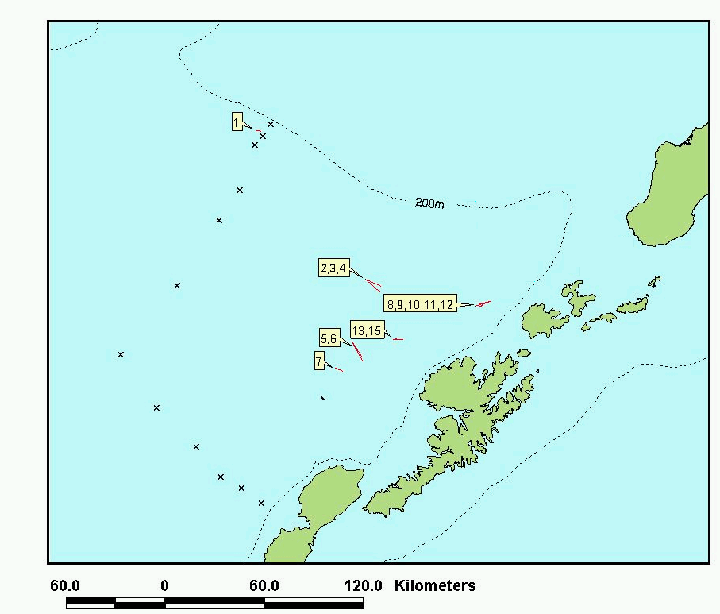
Figure 1. -- Tracklines locations
for CTD stations (*) and approximate locations (based on 1999 trawl locations)
of midwater trawl effort. Marine mammal/bird observations will be conducted
at cruising speed in tracklines between CTD stations. Midwater trawls will
be conducted at two locations at 0-250m; - 500m; and -1000m depths.
Table 1. -- CTD locations and transit
time. CDep is cast depth in meters,
SDep is station (water) depth in meters, Dist is distance
in nautical miles, transit and station time are TranTime and StnTime in
hours, TotT is accumulated time in days. Transits calculated at 10 knots.
Trawling
effort will add a minimum of 6 additional days of activity to the CTD total
time estimate of 1.78 days.
| Activity |
Position |
CDep |
SDep |
Dist |
TranT |
StnT |
TotT |
| Dutch Hbr |
53 54.5, 166 30.9 |
|
|
|
|
|
|
| CTD |
53 22.0, 168 42.0 |
500. |
500. |
84.23 |
8.67 |
0.66 |
0.39 |
| CTD |
53 25.5, 168 46.0 |
1000. |
1000. |
4.23 |
0.67 |
1.03 |
0.46 |
| CTD |
53 31.0, 168 55.0 |
1500. |
1850. |
7.69 |
1.02 |
1.40 |
0.56 |
| CTD |
53 36.0, 169 04.0 |
1500. |
1875. |
7.31 |
0.98 |
1.40 |
0.66 |
| CTD |
53 47.0, 169 16.0 |
1500. |
1575. |
13.08 |
1.56 |
1.40 |
0.78 |
| CTD |
54 02.0, 169 34.0 |
1500. |
1842. |
18.37 |
2.09 |
1.40 |
0.93 |
| CTD |
54 20.0, 169 50.0 |
1500. |
1898. |
20.28 |
2.28 |
1.40 |
1.08 |
| CTD |
54 40.0, 169 12.0 |
1500. |
1730. |
29.80 |
3.23 |
1.40 |
1.27 |
| CTD |
54 58.0, 168 45.0 |
1500. |
2064. |
23.79 |
2.63 |
1.40 |
1.44 |
| CTD |
55 07.0, 168 29.0 |
1500. |
1740. |
12.86 |
1.54 |
1.40 |
1.56 |
| CTD |
55 20.5, 168 15.2 |
1000. |
1000. |
15.63 |
1.81 |
1.03 |
1.68 |
| CTD |
55 22.3, 168 10.5 |
500. |
500. |
3.21 |
0.57 |
0.66 |
1.73 |
| CTD |
55 25.7, 168 04.4 |
200. |
200. |
4.83 |
0.73 |
0.31 |
1.78 |
|