|
Date: 22 September, 1999
FINAL CRUISE REPORT
NOAA Ship MILLER FREEMAN
Cruise No.: MF-99-11
FOCI No.: 7MF99
Applicability:
This report, with the Final
Cruise Instructions dated 30 July 1999, present complete information
for this cruise.
Area:
Southeast Bering Sea
Itinerary:
Depart September 2 — Dutch Harbor
TNG September 5 — Dutch Harbor
Arrive September 19 — Dutch Harbor
Participating organizations:
AFSC - Alaska Fisheries Science Center (NOAA)
PMEL — Pacific Marine Environmental Laboratory (NOAA)
UAF — University of Alaska, Fairbanks
UCI — University of California, Irvine
UW — University of Washington
Cruise description:
Fisheries Oceanography Coordinated Investigations (FOCI) is an effort
by academic and federal scientists to understand ecosystems and biological
and physical processes that cause recruitment variability of commercially
valuable fish and shellfish stocks in Alaskan waters. FOCI is comprised
of Shelikof Strait FOCI and Southeast Bering Sea Carrying Capacity (SEBSCC).
Current research is focused on the western Gulf of Alaska and the southeastern
Bering Sea to examine biotic and abiotic environmental effects on the ecosystem
and the early life stages of walleye pollock. FOCI uses four scientific
approaches: environmental monitoring, process studies, retrospective analyses,
and modeling. Research cruises address the first two approaches.
Cruise objectives:
1) Continue acquisition of long-term biological and physical time series.
2) Conduct acoustic and trawl survey of juvenile walleye pollock for
examining distributions in relation to hydrographic fronts.
3) Compare multiple frequency acoustic systems and their use in examining
zooplankton and juvenile pollock spatial patterns.
4) Collect samples of juvenile pollock for studies of growth, feeding,
pathology, and condition.
5) Examine distribution and nutrition of pollock prey in relation to
hydrographic fronts and vertical distribution of juvenile pollock.
6) Examine distribution and feeding of seabird and marine mammal predators
in the vicinity of the Pribilof Islands.
1.0. PERSONNEL
1.1. Chief Scientist
1.2. Participating Scientists
September 2-19:
| Jay Clark |
M/USA |
AFSC |
| Jeff Napp |
M/USA |
AFSC |
| Loren Tuttle |
M/USA |
AFSC |
| Sigrid Salo |
F/USA |
PMEL |
September 5-19:
| Ken Coyle |
M/USA |
UAF |
| Frank Morado |
M/USA |
AFSC |
| Mary Ngo |
F/USA |
UCI |
| Gordie Swartzman |
M/USA |
UW |
| Lucy Vlietstra |
F/USA |
UCI |
1.3 Program Contacts:
Dr. Phyllis Stabeno
PMEL
7600 Sand Point Way NE
Seattle, WA 98115
(206) 526-6453
Phyllis.Stabeno@noaa.gov |
Dr. Art Kendall
AFSC
7600 Sand Point Way NE
Seattle, WA 98115
(206) 526-4108
|
2.0. CRUISE RESULTS
2.1. Summary of Activities
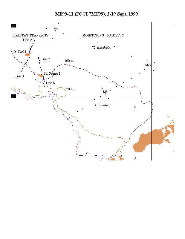
The NOAA ship Miller Freeman departed Dutch Harbor, 2 September
(22:00 ADT). During 2-5 September, sampling was conducted at the 21 southernmost
stations on the Monitoring Transects (Figure 1). On 5 September, the ship
returned to Dutch Harbor to pick up five scientists (see Section 1.2) and
Dr. Ken Coyle’s HTI multi-frequency acoustic system. Within one hour
of arrival, the ship departed for the Habitat Transects with all personnel
and gear aboard. The Habitat Transects were occupied during 5-17 September.
Afterwards, the remaining Monitoring stations were occupied and the cruise
ended on 19 September in Dutch Harbor. A chronological list of all samples
collected and a sample tally are given in Tables 1 and 2, respectively.
All operations were successful except that the CHLAM sensor on the CTD
rosette was damaged. Until it was removed, the CHLAM may have ruined the
PAR and fluorometer data. Attempts to repair the CHLAM were unsuccessful.
1) Monitoring Transects:
Sampling at stations along the Monitoring Transects extended the time
series of available plankton (20/60 cm Bongo), and CTD data across the
shelf and along the 70-m isobath (Table 1 and Figure 1). Water collected
in bottles on the CTD rosette were used to obtain nutrient and chlorophyll
samples at predetermined depths. Sampling was intensified around three
moorings situated along these transects for comparison with data collected
by moored instruments (Figure 1). The CalVET and Methot nets were also
used to collect samples near the moorings. A coccolithophore bloom was
evident along much of these transects and was particularly strong at the
easternmost stations.
2) Habitat Transects:
Sampling commenced with Line D and progressed to Line A (Table 1 and
Figure 1). Extremely high catches of jellyfish in both the anchovy and
Methot nets at two inshore stations on Line A forced cancellation of the
48-hr diel sampling scheduled for the inshore station. Instead, the time
was used to visit Line B and C, and to revisit Line D.
The initial visit to Line D started with a CTD cast at each of the seven
"D" stations. Water collected in bottles on the CTD rosette were
used to obtain nutrient and chlorophyll samples at predetermined depths.
Based on temperature profiles, the inner (well mixed), middle (partially
mixed), and outer (stratified) stations selected for net sampling were
"D2", "D4", and "D6", respectively. In total,
26 hauls were made with the anchovy (n=10), Methot (n=7), and MOCNESS (n=9)
nets. However, eight of these samples (anchovy, n=6; MOCNESS, n=2) were
collected during the revisit to this Line, which was hampered by bad weather.
All acoustic passes were conducted during the initial visit. The HTI acoustic
system was used to make two daytime passes and one nighttime pass. The
EK-500 was used to make one pass each at day, night, and dusk. Bird observations
were made during each of the daytime acoustic transects.
On Line A, a CTD cast was conducted at each of the nine "A"
stations. Water collected in bottles on the CTD rosette were used to obtain
nutrient and chlorophyll samples at predetermined depths. Based on temperature
profiles, the inner (well mixed) and outer (stratified) stations selected
for net sampling were "A2" and "A8", respectively.
The middle (partially mixed) station was chosen midway between "A3"
and "A4" and is referred to as "A3.5". A tenth CTD
cast was done subsequently at this station. Net sampling at the outer and
middle stations occurred over a 48-hr period. At the outer station, 24
hauls were made with the anchovy (n=6), Methot (n=8), and MOCNESS (n=10)
nets. At the middle station, 25 hauls were made with the anchovy (n=6),
Methot (n=10), and MOCNESS (n=9) nets. At the inner station (A8), two hauls
with the anchovy net resulted in huge catches of jellyfish estimated to
weigh about 1 ton. The net burst on the second tow despite the fact that
the net was not allowed to remain at depth. Age-0 pollock samples were
collected from this second tow but it is not useful for quantitative purposes.
We moved to "A7", another inshore station, but the Methot net
caught large numbers of jellyfish at this station also. Diel sampling of
the inshore environment on Line A was therefore cancelled. By that time,
each acoustic system had been used to make one nighttime pass. Each had
also been used to make two daytime passes during which bird observations
were made. Also, a small boat was launched at the middle station and birds
were collected for purposes of a diet study. The only additional sampling
needed was a repeat of the CTD casts and two more nighttime acoustic passes.
However, since the cancellation occurred early in the day and freed up
48 hours, we chose to leave the final sampling of Line A until later and
proceed to Lines B and C.
On Line B and C, a CTD cast was conducted at each station historically
visited. Nutrient and chlorophyll samples were not collected during these
CTD casts. Instead of trying to sample with nets in each habitat, Methot
tows were used to supplement a study of diel sampling effects on catch
composition. Methot samples were collected only on Line B (n=8). The purpose
of the MOCNESS tows was to provide supplemental data for discriminating
echolayers collected with the HTI and EK-500 systems. MOCNESS samples were
collected on Line B (n=3) and on Line C (n=4). On each Line, one daytime
pass was made with each acoustic system. The HTI pass on Line C was conducted
enroute to Line A after briefly revisiting Line D, as mentioned previously.
As with all other daytime passes, bird observations were concurrent with
acoustic collections.
Performance by all hands aboard the Miller Freeman was exemplary. Despite
being short-handed in every department, none of the initial objectives
were compromised. Thanks goes to the officers who put in extra time in
order to conduct the trawl sampling, the deck crew who quickly mended the
anchovy trawl after it burst from the large jellyfish catch, Phil Porter
who willingly tried to fix the CHLAM, the Survey Technicians who were helpful
as always, the galley crew for keeping us well fed, and last but certainly
not least, the engineers for keeping everything running smoothly! Another
big thanks to everyone for willingly adjusting to the many changes that
occurred in the sampling schedule, and for the astonishingly quick touch-and-goes.
2.2. Tables and Figures
Table 1. Station location and operation
during the cruise MF99-11 (FOCI 7MF99).
Table 2. Tally of samples collected during
the cruise MF99-11 (FOCI 7MF99).
Figure 1. Stations on the Monitoring (Cross-shelf
and 70-m isobath) and Habitat (Line A, B, C, D) Transects occupied during
the cruise MF99-11 (FOCI 7MF99).
|