|
CRUISE REPORT
Cruise Number:
MF99-12
FOCI Number: 8MF99
Ship: Miller Freeman
Area of Operations:
Bering Sea
Itinerary:
Dutch Harbor, Alaska,
September 19, 1999
Dutch Harbor, Alaska, September
28, 1999
Participating Organizations:
NOAA - Pacific Marine
Environmental Laboratory (PMEL)
NOAA - Alaska Fisheries Science
Center (AFSC)
University of Alaska - Fairbanks
(UAF)
Chief Scientist:
William Parker, M,
PMEL
Participating Scientists:
Sigrid Salo, F, PMEL
Kurt Zegowitz, M, PMEL
Stacy Smith, F, UAF
Jennifer Danielson, F, UAF
Objectives of the Cruise:
1. Recover and
deploy moorings at the FOCI study areas of St. George Island, site #2,
site #3, and site #4.
2 Recover NSF moorings
at the Slime Bank, Bristol Bay, and Nunivak Island study areas.
3. Conduct biological sampling
in project areas.
4. Complete CTD lines at
and between mooring sites.
5. Pribilof Canyon survey
6. Deploy Seimac drifting
buoys.
Operations:
Mooring Deployments:4
site# 2- 3
site# 3- 1
Mooring Recoveries:12
Nunivak Is.- 1
St. George Is.- 2
site# 2- 3
site# 4- 1
Slime Bank- 4
Cape Newenham- 1
CTDs: 34
Bongo Tows: 4
Satellite Drifters: 3
Summary of Cruise:
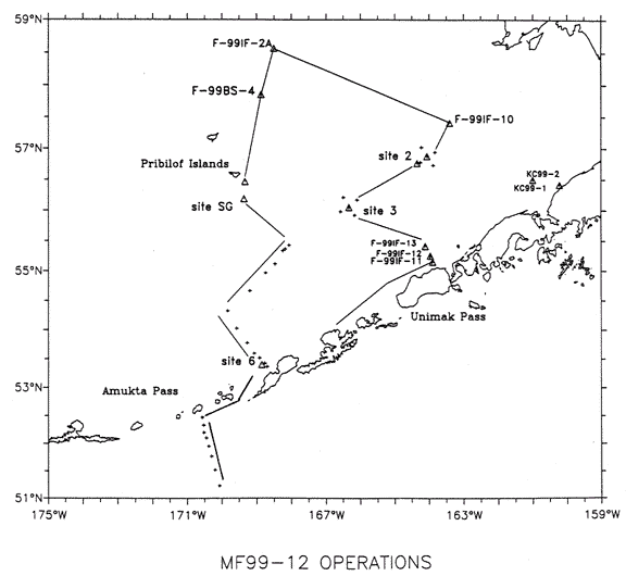
The MF99-12 cruise
itinerary and plot are included in the attachments.
The MF99-12 mooring recovery
operations:
99IF-11 (37 meters):
Subsurface mooring. Recovery time 29 minutes (08:54/09:23 L). Normal recovery.
99IFM-12 (59 meters):
Surface mooring. Recovery time 1 hour, 18 minutes (10:20/11:38 L). Small
boat used for recovery. Normal recovery.
99IFP-12 (59 meters):
Subsurface mooring, ADCP on bar. Recovery time 13 minutes (12:38/12:51
L). Normal recovery.
99IF-13 (97 meters):
Subsurface mooring. Recovery time 51 minutes (14:41/15:32 L). Normal recovery.
99BSST-3S (124 meters):
Subsurface mooring, University of Alaska Sediment Trap. Recovery time 30
minutes, (23:26/23:56 L) Normal recovery.
99BSST-2S (74 meters):
Subsurface mooring, University of Alaska Sediment Trap. Recovery time 13
minutes (09:27/09:40 L). Normal recovery.
99BSM-2 (74 meters):
Surface mooring. Recovery time 1 hour, 10 minutes (11:59/13:09 L). Surface
buoy showed some damage from ice. Seacat pump mounted on the Seacat attached
to the buoy bridal had broken free and was hanging loose below the buoy.
The buoy light battery box was flooded. The light was operating. The RCM-9
was damaged during recovery.
99IF-10 (53 meters):Subsurface
mooring. Recovery time 44 minutes (21:34/22:18 L). Normal recovery.
99IF-2A (60 meters):
Subsurface mooring. Recovery time 35 minutes (14:35/15:10 L). Rotor missing
on RCM 5261 on recovery.
99BS-4 (73 meters):
Subsurface mooring. Recovery time 50 minutes (19:17/20:07 L). Normal recovery.
99SG-1 (597 meters):
Subsurface mooring. Recovery time 50 minutes (08:45/09:35 L). Mooring tangled
on recovery.
99SG-3 (103 meters):
Subsurface mooring, ADP on bar. Recovery time 14 minutes (12:01/12:15 L).
Normal recovery.
The MF99-12 mooring deployments:
99BS-2C (72 meters):
Subsurface mooring. Deployment time 45 minutes ( 14:30/15:15L).
99BSST-2F (72 meters):
Subsurface mooring, University of Alaska Sediment Trap. Deployment time
1 hour (15:29/16:29 L).
99BSP-2F (72 meters):
Subsurface mooring, ADCP on bar. Deployment time 30 minutes (17:25/17:55
L).
99BSST-3F (120 meters):Subsurface
mooring, University of Alaska Sediment Trap. Deployment time 1 hour (14:24/15:24
L).
We would like to thank the officers
and crew of the Miller Freeman for their efforts to complete the PMEL/AFSC
operations on MF99-12.
Attachments:
Cruise Itinerary
| Activity |
Latitude |
|
|
Longitude |
|
|
Dist. |
Spd |
Trans |
On
Sta |
Arrive
(Local) |
Depart |
| |
|
|
|
|
|
|
(nm) |
(kts) |
(hrs) |
(hrs) |
Date
/ Time |
Date
/ Time |
| Depart Dutch Harbor |
53° |
55' |
N |
166° |
31' |
W |
|
|
|
|
|
19-Sep
21:00 |
| Deploy Seimac Drifting
Buoy 20381 |
54° |
40' |
N |
165° |
45' |
W |
52.8 |
11 |
4.8 |
0.0 |
20-Sep
01:48 |
20-Sep
01:48 |
| CTD/Recover- F-99IF-11(36m) |
55° |
09' |
N |
163° |
54' |
W |
70.1 |
12 |
5.8 |
1.8 |
20-Sep
07:38 |
20-Sep
09:26 |
| CTD/Recover- F-99IFM-12(56m) |
55° |
15' |
N |
163° |
58' |
W |
6.6 |
10 |
0.7 |
1.5 |
20-Sep
10:06 |
20-Sep
11:36 |
| Recover-F-99IFP-12(600khz) |
55° |
15' |
N |
163° |
58' |
W |
0.2 |
0.2 |
0.8 |
0.5 |
20-Sep
12:22 |
20-Sep
12:52 |
| CTD/Recover- F-99IF-13(96m) |
55° |
25' |
N |
164° |
07' |
W |
11.0 |
8 |
1.4 |
1.4 |
20-Sep
14:14 |
20-Sep
15:38 |
| Recover- F-99BSST-3S(124m) |
56° |
03' |
N |
166° |
20' |
W |
84.2 |
11 |
7.7 |
0.6 |
20-Sep
23:18 |
20-Sep
23:54 |
| CTD/Bongo (site 3) |
56° |
03.0' |
N |
166° |
20.0' |
W |
0.0 |
10 |
0.0 |
1.5 |
20-Sep
23:54 |
21-Sep
01:24 |
| Search(98BSP-2F)/CTD/Bongo
(site 2se) |
56° |
43.9 |
N |
163° |
53.0 |
W |
91.1 |
13 |
7.0 |
0.1 |
21-Sep
08:24 |
21-Sep
08:30 |
| Recover- F-99BSST-2S |
56° |
45.9 |
N |
164° |
20.7 |
W |
15.3 |
13 |
1.2 |
0.2 |
21-Sep
09:41 |
21-Sep
09:53 |
| CTD/Bongo/Recover- BSM99-2 |
56° |
52.5 |
N |
164° |
03.0 |
W |
11.7 |
10 |
1.2 |
2.5 |
21-Sep
11:03 |
21-Sep
13:33 |
| Deployment-F-99BS-2C |
56° |
52.5 |
N |
164° |
03.0 |
W |
0.0 |
10 |
0.0 |
1.9 |
21-Sep
13:33 |
21-Sep
15:27 |
| Deployment- F-99BSST-2F |
56° |
52.5 |
N |
164° |
03.1 |
W |
0.1 |
10 |
0.0 |
2.0 |
21-Sep
15:27 |
21-Sep
17:27 |
| Deployment-F-99BSP-2F/CTD |
56° |
52.5 |
N |
164° |
03.0 |
W |
0.1 |
10 |
0.0 |
1.0 |
21-Sep
17:28 |
21-Sep
18:28 |
| CTD/Recovery- F-99IF-10(53m) |
57° |
24' |
N |
163° |
24' |
W |
38.2 |
12.5 |
3.1 |
1.0 |
21-Sep
21:31 |
21-Sep
22:31 |
| Survey of 97IFP- 3 |
58° |
42.5 |
N |
168° |
16.6 |
W |
173.1 |
11.8 |
14.7 |
0.1 |
22-Sep
13:11 |
22-Sep
13:17 |
| CTD/Recovery- IF99-2A(56m) |
58° |
33.9 |
N |
168° |
23.9 |
W |
9.4 |
12 |
0.8 |
1.5 |
22-Sep
14:05 |
22-Sep
15:35 |
| Survey of 97IFP-2 |
58° |
37.9 |
N |
168° |
21.8 |
W |
4.2 |
13.5 |
0.3 |
0.1 |
22-Sep
15:53 |
22-Sep
15:59 |
| CTD/Recovery- F-99BS-4(72m) |
57° |
51.1 |
N |
168° |
52.4 |
W |
49.5 |
14 |
3.5 |
1.0 |
22-Sep
19:31 |
22-Sep
20:31 |
| Pribilof Canyon Survey
line 1 |
56° |
30.0 |
N |
169° |
15.0 |
W |
82.0 |
12 |
6.8 |
0.1 |
23-Sep
03:21 |
23-Sep
03:27 |
| Pribilof Canyon Survey
line 1 |
55° |
55.0 |
N |
169° |
15.0 |
W |
35.0 |
11 |
3.2 |
0.1 |
23-Sep
06:38 |
23-Sep
06:44 |
| CTD/Recovery- SG99-1(598m) |
56° |
11.1 |
N |
169° |
20.0 |
W |
16.3 |
11 |
1.5 |
2.5 |
23-Sep
08:13 |
23-Sep
10:43 |
| CTD/Recovery- SGP99-3(130m) |
56° |
19.0 |
N |
169° |
20.1 |
W |
7.9 |
10 |
0.8 |
1.0 |
23-Sep
11:31 |
23-Sep
12:31 |
| Pribilof Canyon Survey
line 2 |
56° |
25.0 |
N |
169° |
30.0 |
W |
8.1 |
11.2 |
0.7 |
0.1 |
23-Sep
13:14 |
23-Sep
13:20 |
| Pribilof Canyon Survey
line 2 |
55° |
55.0 |
N |
169° |
30.0 |
W |
30.0 |
11.2 |
2.7 |
0.1 |
23-Sep
16:01 |
23-Sep
16:07 |
| Pribilof Canyon Survey
line 3 |
55° |
55.0 |
N |
169° |
45.0 |
W |
8.4 |
11.2 |
0.8 |
0.1 |
23-Sep
16:52 |
23-Sep
16:58 |
| Pribilof Canyon Survey
line 3 |
56° |
25.0 |
N |
169° |
45.0 |
W |
30.0 |
11.2 |
2.7 |
0.1 |
23-Sep
19:39 |
23-Sep
19:45 |
| Pribilof Canyon Survey
line 4 |
56° |
15.0 |
N |
170° |
00.0 |
W |
13.0 |
11.2 |
1.2 |
0.1 |
23-Sep
20:54 |
23-Sep
21:00 |
| Pribilof Canyon Survey
line 4 |
56° |
15.0 |
N |
169° |
00.0 |
W |
33.3 |
11.2 |
3.0 |
0.1 |
23-Sep
23:59 |
24-Sep
00:05 |
| Pribilof Canyon Survey
line 5 |
56° |
06.0 |
N |
169° |
00.0 |
W |
9.0 |
11.2 |
0.8 |
0.1 |
24-Sep
00:53 |
24-Sep
00:59 |
| Pribilof Canyon Survey
line 5 |
56° |
06.0 |
N |
170° |
00.0 |
W |
33.5 |
11.2 |
3.0 |
0.1 |
24-Sep
03:58 |
24-Sep
04:04 |
| Deployment/CTD/Bongo-
F-99BSST-3F(124m) |
56° |
03' |
N |
166° |
20' |
W |
122.8 |
12 |
10.2 |
1.5 |
24-Sep
14:19 |
24-Sep
15:49 |
| CTD -200 meters |
55° |
25.7 |
N |
168° |
04.4 |
W |
69.6 |
12 |
5.8 |
1.0 |
24-Sep
21:37 |
24-Sep
22:37 |
| CTD-500 meters |
55° |
22.3 |
N |
168° |
10.5 |
W |
4.9 |
12 |
0.4 |
1.0 |
24-Sep
23:01 |
25-Sep
00:01 |
| CTD-1000 meter |
55° |
20.5 |
N |
168° |
15.2 |
W |
3.2 |
12 |
0.3 |
2.5 |
25-Sep
00:17 |
25-Sep
02:47 |
| CTD-1500 meter |
55° |
07.0 |
N |
168° |
29.0 |
W |
15.6 |
12 |
1.3 |
1.5 |
25-Sep
04:05 |
25-Sep
05:35 |
| CTD-1500 meter |
54° |
58.0 |
N |
168° |
45.0 |
W |
12.8 |
12 |
1.1 |
1.5 |
25-Sep
06:40 |
25-Sep
08:10 |
| CTD-1500 meter |
54° |
40.0 |
N |
169° |
12.0 |
W |
23.8 |
12 |
2.0 |
1.5 |
25-Sep
10:08 |
25-Sep
11:38 |
| CTD-1500 meter |
54° |
20.0 |
N |
169° |
50.0 |
W |
29.8 |
12 |
2.5 |
1.5 |
25-Sep
14:07 |
25-Sep
15:37 |
| CTD-1500 meter |
54° |
02.0 |
N |
169° |
34.0 |
W |
20.3 |
12 |
1.7 |
1.5 |
25-Sep
17:19 |
25-Sep
18:49 |
| CTD-1500 meter |
53° |
47.0 |
N |
169° |
16.0 |
W |
18.4 |
12 |
1.5 |
1.5 |
25-Sep
20:21 |
25-Sep
21:51 |
| CTD-1500 meter |
53° |
36' |
N |
169° |
04' |
W |
13.1 |
11 |
1.2 |
1.5 |
25-Sep
23:02 |
26-Sep
00:32 |
| CTD-1500 meter |
53° |
31.0 |
N |
168° |
55.0 |
W |
7.3 |
11 |
0.7 |
1.5 |
26-Sep
01:12 |
26-Sep
02:42 |
| CTD-1000 meters (site
6) |
53° |
26' |
N |
168° |
46' |
W |
7.7 |
11 |
0.7 |
1.5 |
26-Sep
03:24 |
26-Sep
04:54 |
| Deploy Seimac Drifting
Buoy 15791 |
53° |
26' |
N |
168° |
46' |
W |
0.0 |
11 |
0.0 |
0.1 |
26-Sep
04:54 |
26-Sep
05:00 |
| CTD-300 meter |
53° |
22.0 |
N |
168° |
42.0 |
W |
4.2 |
11 |
0.4 |
0.7 |
26-Sep
05:23 |
26-Sep
06:05 |
| CTD-320 meters |
52° |
28' |
N |
170° |
34' |
W |
86.5 |
11 |
7.9 |
0.7 |
26-Sep
13:57 |
26-Sep
14:39 |
| CTD-510 meters |
52° |
20' |
N |
170° |
32' |
W |
8.1 |
11 |
0.7 |
1.0 |
26-Sep
15:23 |
26-Sep
16:23 |
| CTD-1370 meters |
52° |
12' |
N |
170° |
31' |
W |
8.0 |
11 |
0.7 |
1.5 |
26-Sep
17:07 |
26-Sep
18:37 |
| CTD-2730 meters |
52° |
06' |
N |
170° |
27' |
W |
6.5 |
11 |
0.6 |
1.5 |
26-Sep
19:12 |
26-Sep
20:42 |
| CTD-3000 meters (3370) |
51° |
57' |
N |
170° |
23' |
W |
9.3 |
11 |
0.8 |
1.5 |
26-Sep
21:33 |
26-Sep
23:03 |
| CTD-3000 meters (3480) |
51° |
46' |
N |
170° |
18' |
W |
11.4 |
11 |
1.0 |
1.5 |
27-Sep
00:05 |
27-Sep
01:35 |
| CTD-3000 meters (4940) |
51° |
31' |
N |
170° |
12' |
W |
15.5 |
11 |
1.4 |
1.5 |
27-Sep
02:59 |
27-Sep
04:29 |
| CTD-3000 meters >(5000) |
51° |
14' |
N |
170° |
04' |
W |
17.7 |
11 |
1.6 |
1.5 |
27-Sep
06:06 |
27-Sep
07:36 |
| Deploy Seimac Drifting
Buoy 15789 |
54° |
00.0 |
N |
167° |
30.2 |
W |
190.4 |
11 |
17.3 |
0.1 |
28-Sep
00:55 |
28-Sep
01:01 |
| Arrive Dutch Harbor |
53° |
55' |
N |
166° |
31' |
W |
35.3 |
11 |
3.2 |
|
28-Sep
04:13 |
|
Mooring Plot
|