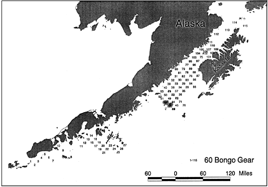
The first leg of the cruise was
accomplished with Annette Brown as the field party chief, conducting an
ichthyoplankton survey between Unimak Pass and the Shumagin Islands from
May 21 to May 24. The ship then proceeded to Kodiak to pick up both the
Munson for small vessel work and the remaining scientists.
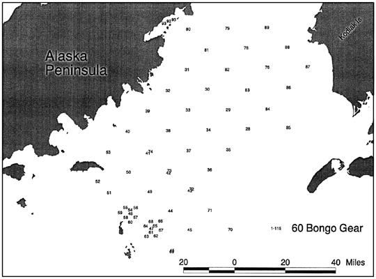
A pre-survey was conducted to set a threshhold
for an adaptive survey of the Kodiak to Semidi Island region. The pre-survey
took approximately 30 h. A Mocness series was conducted with 8 nets towed
obliquely from 100m to the surface in a consecutive series to examine small-scale
horizontal patchiness.
The adpative sampling grid was occupied
for approximately 81 hours in coordination with sampling by the Wecoma.
The grid sampling was delayed by an emergency dropoff of a scientist in
Larsen Bay, the onset of a storm with high winds and waves, during which
sampling was dangerous, and the rescue of a small fishing vessel floundering
in the storm. These activities took about 22 hours.
During the final portion of the cruise,
the bongo survey was extended through the upper portion of Shelikof Strait
and small vessel (Munson) sampling in waters inaccessible to the Freeman
was conducted using the 60cm bongo gear. Three tows were completed using
the Munson in Wide Bay and Uyak Bay. In general, the small vessel work
was successful as an intitial attempt, and some recommendations for improving
the sampling capability of the Munson will be made.
The officers and crew of the Miller Freeman
did an extremely good job meeting the demands of the scientific sampling
required during this cruise. Particularly during the adaptive sampling
and Munson sampling projects the crew needed to be flexible and make some
adjustments and decisions in haste, which they accomplished admirably.
| Date |
Time |
|
|
FOCI |
Alternate |
Depth |
|
|
|
|
|
|
|
| (GMT) |
(GMT) |
Station |
Haul |
Grid No. |
Station No. |
(m) |
Latitude
N |
Longitude
W |
Gear |
Samples Collected |
Haul Comments |
| 15-May |
2:38 |
1 |
1 |
|
|
339 |
55° |
24.90' |
168° |
11.80' |
60Bon |
QTowF |
|
| 15-May |
2:38 |
1 |
1 |
|
|
339 |
55° |
24.90' |
168° |
11.80' |
CAT |
CAT |
|
| 16-May |
1:05 |
2 |
1 |
|
|
798 |
54° |
28.00' |
167° |
19.10' |
60Bon |
QTowF |
Total tow time estimated from wire out. |
| 16-May |
1:05 |
2 |
1 |
|
|
798 |
54° |
28.00' |
167° |
19.10' |
CAT |
CAT |
Total tow time estimated from wire out. |
| 16-May |
23:09 |
3 |
1 |
|
|
1850 |
54° |
05.08' |
167° |
36.41' |
60Bon |
QTowF |
|
| 16-May |
23:09 |
3 |
1 |
|
|
1850 |
54° |
05.08' |
167° |
36.41' |
CAT |
CAT |
|
| 17-May |
7:34 |
4 |
1 |
|
|
0 |
54° |
03.62' |
167° |
46.46' |
60Bon |
QTowF |
Bottom depth not recorded. Max gear depth
not recorded; based on other similar tows. |
| 17-May |
7:34 |
4 |
1 |
|
|
0 |
54° |
03.62' |
167° |
46.46' |
CAT |
CAT |
Bottom depth not recorded. Max gear depth
not recorded; based on other similar tows. |
| 18-May |
4:08 |
5 |
1 |
|
|
1123 |
54° |
16.90' |
166° |
27.90' |
60Bon |
QTowF |
|
| 18-May |
4:08 |
5 |
1 |
|
|
1123 |
54° |
16.90' |
166° |
27.90' |
CAT |
CAT |
|
| 18-May |
16:53 |
6 |
1 |
|
|
1159 |
54° |
15.86' |
166° |
27.71' |
60Bon |
QTowF |
|
| 18-May |
16:53 |
6 |
1 |
|
|
1159 |
54° |
15.86' |
166° |
27.71' |
CAT |
CAT |
|
| 18-May |
22:01 |
7 |
1 |
|
|
47 |
54° |
26.45' |
164° |
58.63' |
60Bon |
QTowF |
|
| 18-May |
22:01 |
7 |
1 |
|
|
47 |
54° |
26.45' |
164° |
58.63' |
CAT |
CAT |
|
| 18-May |
23:06 |
8 |
1 |
|
|
142 |
54° |
24.35' |
165° |
07.49' |
60Bon |
QTowF |
|
| 18-May |
23:06 |
8 |
1 |
|
|
142 |
54° |
24.35' |
165° |
07.49' |
CAT |
CAT |
|
| 19-May |
0:33 |
9 |
1 |
|
|
174 |
54° |
22.10' |
165° |
16.55' |
60Bon |
QTowF |
|
| 19-May |
0:33 |
9 |
1 |
|
|
174 |
54° |
22.10' |
165° |
16.55' |
CAT |
CAT |
|
| 19-May |
1:53 |
10 |
1 |
|
|
150 |
54° |
20.30' |
165° |
25.20' |
60Bon |
QTowF |
|
| 19-May |
1:53 |
10 |
1 |
|
|
150 |
54° |
20.30' |
165° |
25.20' |
CAT |
CAT |
|
| 19-May |
4:59 |
11 |
1 |
|
|
480 |
54° |
21.89' |
165° |
55.50' |
60Bon |
QTowF |
Tow time not recorded. Estimated from
wireout. |
| 19-May |
4:59 |
11 |
1 |
|
|
480 |
54° |
21.89' |
165° |
55.50' |
CAT |
CAT |
Tow time not recorded. Estimated from
wireout. |
| 19-May |
6:54 |
12 |
1 |
|
|
550 |
54° |
28.23' |
166° |
01.61' |
60Bon |
QTowF |
Tow time not recorded. Estimated from
wire out. |
| 19-May |
6:54 |
12 |
1 |
|
|
550 |
54° |
28.23' |
166° |
01.61' |
CAT |
CAT |
Tow time not recorded. Estimated from
wire out. |
| 19-May |
8:44 |
13 |
1 |
|
|
427 |
54° |
34.21' |
166° |
07.65' |
60Bon |
QTowF |
|
| 19-May |
8:44 |
13 |
1 |
|
|
427 |
54° |
34.21' |
166° |
07.65' |
CAT |
CAT |
|
| 19-May |
10:31 |
14 |
1 |
|
|
288 |
54° |
40.98' |
166° |
14.07' |
60Bon |
QTowF |
|
| 19-May |
10:31 |
14 |
1 |
|
|
288 |
54° |
40.98' |
166° |
14.07' |
CAT |
CAT |
|
| 19-May |
12:04 |
15 |
1 |
|
|
188 |
54° |
47.75' |
166° |
20.63' |
60Bon |
QTowF |
|
| 19-May |
12:04 |
15 |
1 |
|
|
188 |
54° |
47.75' |
166° |
20.63' |
CAT |
CAT |
|
| 20-May |
12:48 |
16 |
1 |
|
|
1410 |
54° |
10.41' |
167° |
11.56' |
60Bon |
QTowF |
Tow time not recorded; estimated from
wireout. Bottom depth not recorded in MOA; estimated from previous haul. |
| 20-May |
12:48 |
16 |
1 |
|
|
1410 |
54° |
10.41' |
167° |
11.56' |
CAT |
CAT |
Tow time not recorded; estimated from
wireout. Bottom depth not recorded in MOA; estimated from previous haul. |