


|
|
|
| February 19, 2026 |
|
|
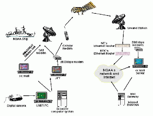
| Capture and transmission of images |
 |
|
Access to the internet from ships at sea can help scientists improve the efficiency and effectiveness of their missions, and increase the quality of the environmental data gathered. Data from the ships transmitted to land based facilities via the Internet can be analyzed with more powerful computers and by several collaborating scientists. This analysis provides scientists aboard the ships with valuable information needed to make adjustments to their data sampling. In addition, data available from NOAA and other internet sources, such as weather and sea conditions, improves the mariner's ability to plan ship movements to maximize data collection. Successful implementation of this cutting edge technology can provide other researchers around the world with a blueprint to connect other remote environmental data acquisition platforms. Applications of the Internet at Sea links include:
NOAA's HPCC project provided funding in FY96 and FY97 in support of this demonstration project. The demonstration activity started the process of installing an INMARSAT B satellite communication transceiver with a high speed data (56 to 64 kB/sec) channel on two research ships and a connection, via an existing router at the Pacific Marine Environmental Lab in Seattle, to the North West Network backbone. INMARSAT B with high speed data channel become commercially available in FY97 and was installed as soon as upgrades became available. Network upgrades, satellite hardware installations and connections were implemented in FY98. A preliminary investigation of the capabilities of this process was been conducted using the facilities of the NOAA Ship Ka'imimoana. NC conducted preliminary work in the use of INMARSAT A for ship to shore connectivity via land based networks. FY 96 activities:
FY 97 activities:
FY 98 activities:
Continuing activities:
|
|
home | about | cruises | research | photos |
|
US
Department of Commerce |
NOAA | OAR
| PMEL
Fisheries Oceanography Coordinated Investigations (FOCI) 7600 Sand Point Way NE Seattle, WA 98115 Disclaimer | Privacy notice | Credits |