Data from the April 2015 eruption at Axial Seamount
This page displays plots of data recorded during the April 2015 eruption at Axial Seamount from the Bottom Pressure / Tilt instruments (BOTPT) that are part of the National Science Foundation's (NSF) Ocean Observatories Initiative (OOI) Cabled Array seafloor observatory, operated by the University of Washington. The dates/times in the plots below are in GMT (+8 hrs of local standard time, or +7 hrs of DLS time on the US west coast). Note the MJ03D BOTPT at International District was off-line during the event. These plots are static (not updated).
LINK BACK TO PAGE WITH MAPS AND OTHER INSTRUMENTS
Temperature data (from the NANO-BPRs) - early evidence for an eruption
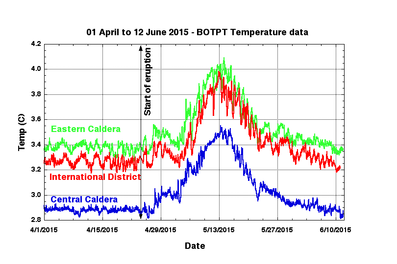
Temperature records from the 3 NANO-BPR instruments since 01 Apr 2015, showing a temperature increase starting late on 24 April. This temperature increase is evidence that lava was erupted on the seafloor somewhere nearby.
Bottom Pressure Recorder (NANO-BPR) data
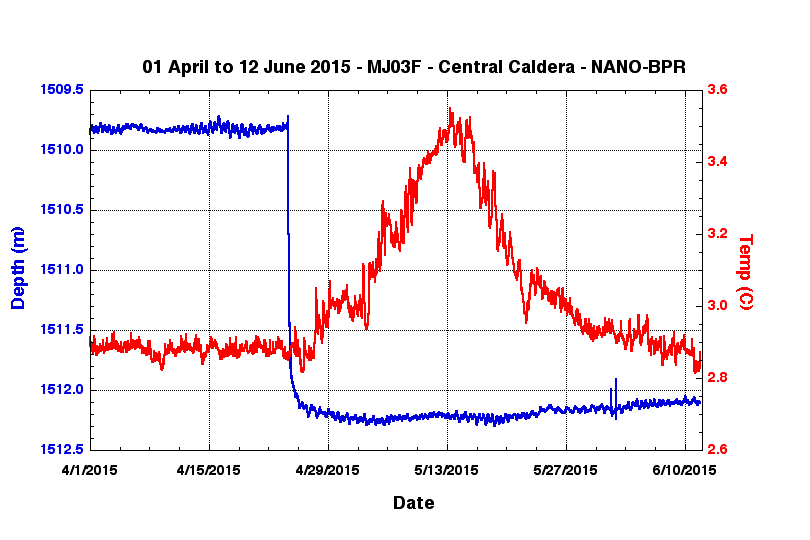
NANO-BPR data from MJ03F (Central Caldera) since 01 April 2015. The blue curve is seafloor depth in meters and the red curve is temperature (°C), both subsampled to every 15 sec. Here, the seafloor subsided over 2.4 m (about the same amount as in 2011). The start of subsidence was at 24-Apr @ 06:15.
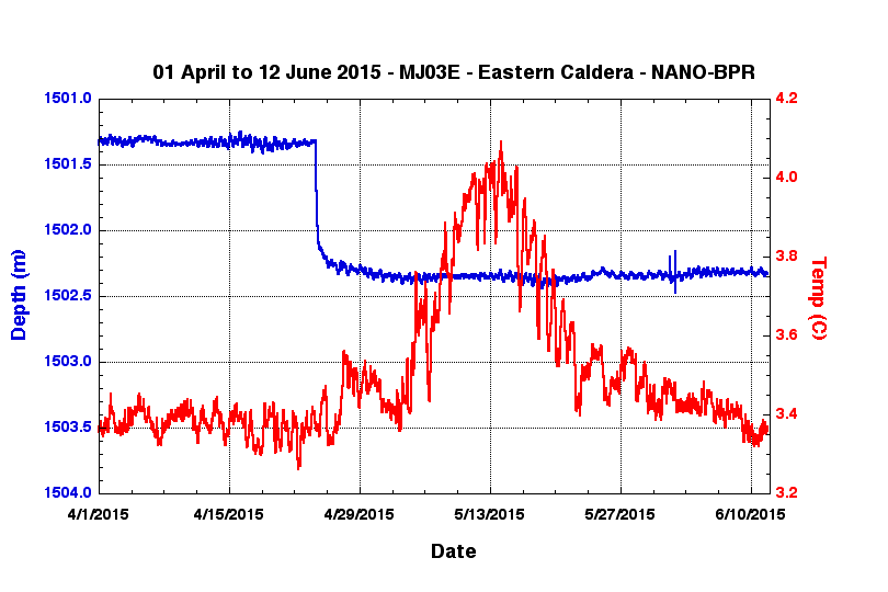
NANO-BPR data from MJ03E (Eastern Caldera) since 01 April 2015. The blue curve is seafloor depth in meters and the red curve is temperature (°C), both subsampled to every 15 sec. Here, the seafloor subsided over 1 m. The start of subsidence was at 24-Apr @ 06:00 (15 minutes earlier than at MJ03F, above). The y-axes ranges are the same in the plots to aid comparison.
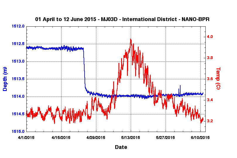
NANO-BPR data from MJ03D (International District) since 01 April 2015. The blue curve is seafloor depth in meters and the red curve is temperature (°C), both subsampled to every 15 sec. Here, the seafloor subsided 1.4 m. Unfortunately this instrument was off-line during the 24 April event. The y-axes ranges are the same in the plots to aid comparison.
Comparison of BPR data from the 2011 eruption vs. the 2015 eruption
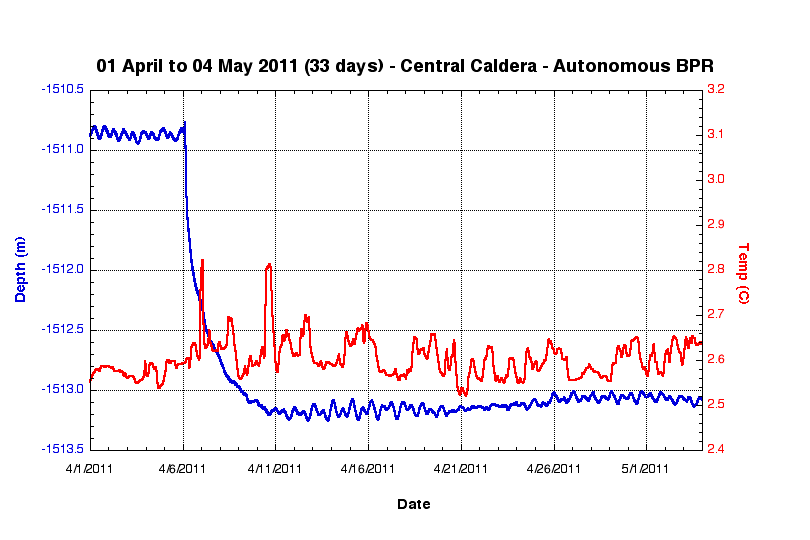
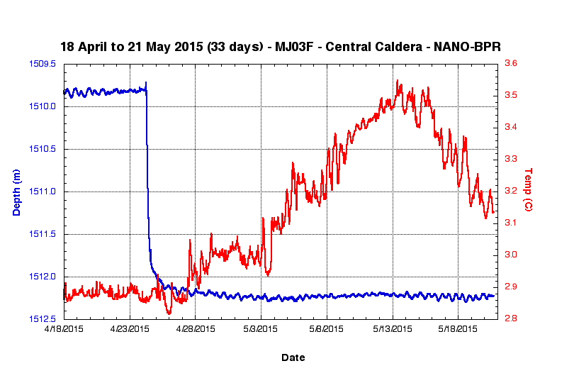
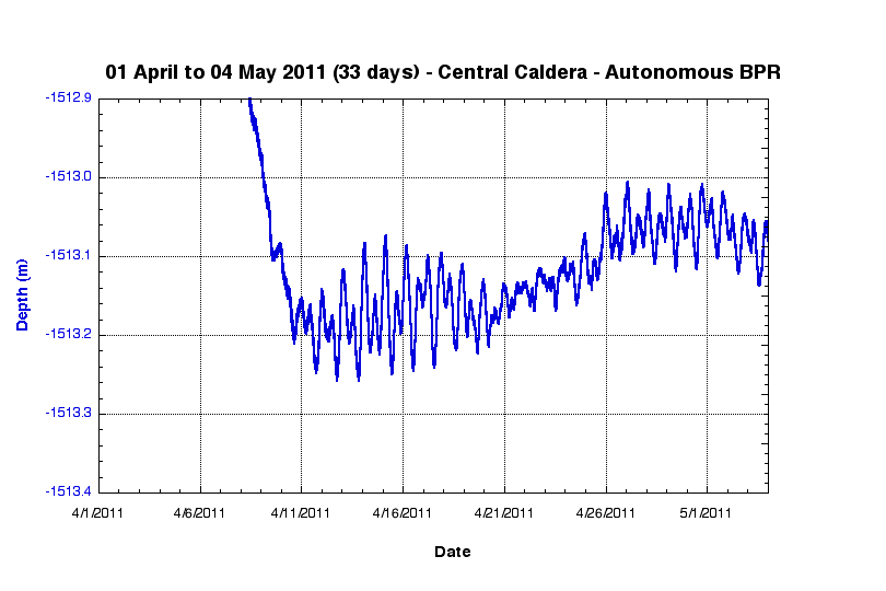
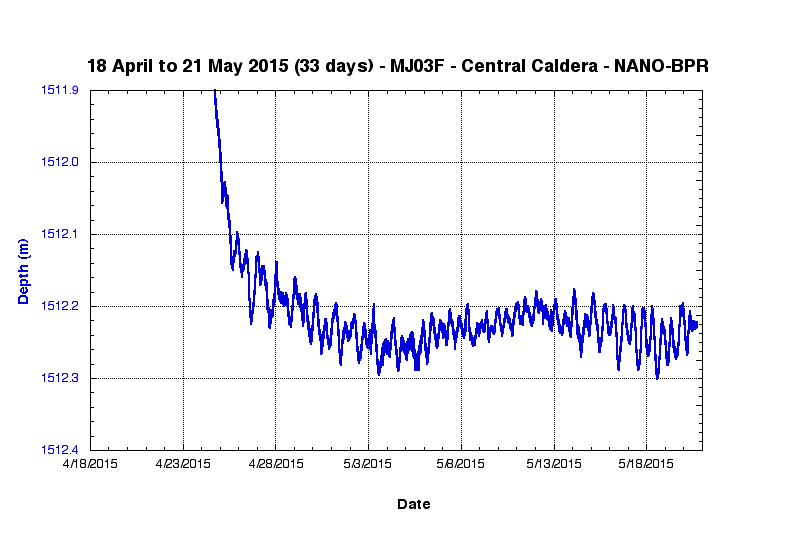
Comparison of BPR data from the 2011 eruption (left) vs. the 2015 eruption (right). These data are all from the center of the caldera (nearly the same location), but from different instruments. All the plots are over 33 days on the X-axis. The ones with temperature (upper plots) are scaled with 3 meters on the left Y-axis (depth, in blue), and 0.8°C on the right Y-axis (temperature, in red). The ones without temperature (lower plots) are zoomed in to look at the deflation/re-inflation transition and are scaled to 0.5 m depth on the Y-axis. Right-click on each plot and "save as" for larger versions of the plots.
Notes:
* The temperature rise in 2015 has been more gradual but far larger in magnitude and longer-lived than the one in 2011 (when lava flows were on the seafloor only 540 m from the instrument!). However, the temperature sensor in 2011 was inside a much larger pressure case, so not as sensitive to ambient temperature changes. What is the bigger/longer temperature increase telling us?
* The depth records (de-tided with the SPOTL predicted tides) show the amount of subsidence is almost the same from the two events, but the 2015 subsidence is much more rapid than in 2011. On the other hand, the subsidence goes on longer at a low rate after the big drop (11 days by my count), whereas in 2011 you could argue the subsidence only lasts 6 days before re-inflation kicks in (but it's hard to pinpoint the turn-around). What is this telling us? A more vigorous and longer-lived eruption in 2015?
* The rate of re-inflation appears to be lower in 2015, and it's possible we're even seeing continued deflation, but it will take more time to tell. See also the long-term rates page.
High-resolution tiltmeter (LILY) data - from 24-27 April 2015
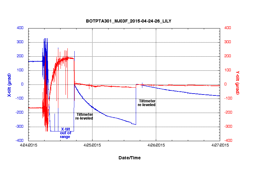
LILY tiltmeter data from MJ03F (Central Caldera) from 24-27 April 2015 with X- and Y-axis tilts in microradians (µrad). Note the X-tilt axis went off-scale during the event (@ -330 µrad). The spikes are from earthquakes.
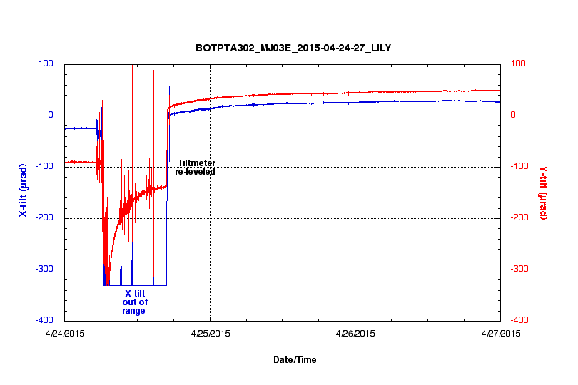
LILY tiltmeter data from MJ03E (Eastern Caldera) from 24-27 April 2015 with X- and Y-axis tilts in microradians (µrad). Note the X-tilt axis went off-scale during the event (@ -330 µrad). The spikes are from earthquakes.
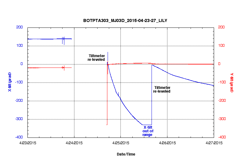
LILY tiltmeter data from MJ03D (International District) from 24-27 April 2015 with X- and Y-axis tilts in microradians (µrad). Unfortunately, this instrument was off-line during the 24 April event
Low-resolution tiltmeter (IRIS) data - from 24-27 April 2015
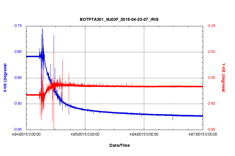
IRIS tiltmeter data from MJ03F (Central Caldera) from 24-27 April 2015 with X- and Y-axis tilts in degrees. The spikes are from earthquakes.
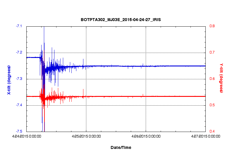
IRIS tiltmeter data from MJ03E (Eastern Caldera) from 24-27 April 2015 with X- and Y-axis tilts in degrees. The spikes are from earthquakes.
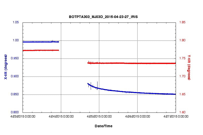
IRIS tiltmeter data from MJ03D (International District) from 23-27 April 2015 with X- and Y-axis tilts in degrees. The spikes are from earthquakes. Unfortunately, this instrument was off-line from 23 Apr @ 22:41 to 24 Apr @16.41.
More information
National Science Foundation | The Ocean Observatories Initiative | Cabled Array Observatory
Required OOI disclaimer: This is provided as pre-commissioned data intended for scientific use, and is subject to the OOI Data Policy. This data has not been through Quality Assurance checks.
Required NSF disclaimer: This material is based upon work supported by the National Science Foundation. Any opinions, findings, and conclusions or recommendations expressed in this material are those of the author(s) and do not necessarily reflect the views of the National Science Foundation.