|
 |
|
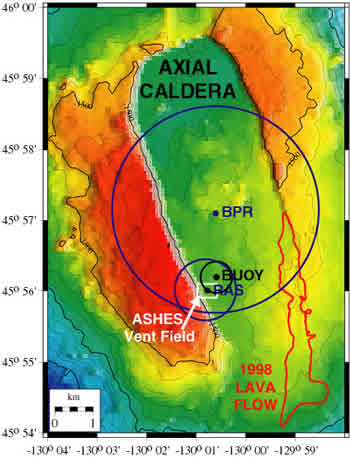
Bathymetric
map of the summit of Axial volcano, showing the caldera, the 1998 lava
flow, and the locations of the components of the NeMO Net 2002 system.
The NeMO Net surface buoy
is anchored at the black dot and its mooring keeps it within the black
watch-circle. The Bottom
Pressure Recorder (BPR) and two Remote
Access Samplers (RAS) are located on the seafloor at the blue dots.
The blue circles show the maximum range of the directional (for the RAS)
and omni-directional (for the BPR) acoustic modems. The new omni-directional
modem clearly has much greater range and therefore gives the monitoring
system much greater flexibility.
|