WHAT'S NEW:
Eruption Confirmed!
New lava (rumbleometer stuck in flow) SE rift zone
(posted 9/1/98)
BACKGROUND:
Technology (ROV, ships, etc.)
Other 1998 Axial cruise reports
EXPEDITION:
Science Objectives
Calendar
Today's Science News
Participant Perspective
Teacher Logbook
EDUCATION:
Curriculum
Teacher Observations
Questions/Answers from sea
MULTIMEDIA:
(video clips, animations, sounds)
Logbook
September 6, 1998
September 6, 1998
See
Highlights Section for the Chief Scientist's weekly report'
(includes the ROPOS video clip)
Contents:
Science Report
Daily Science Report - Sep 6
ship's location = 45 42.5N/130 21.5W
|
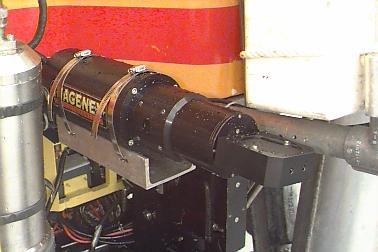
Imagenex instrument mounted on the ROPOS ROV |
ROPOS dive 467 to the Axial north rift zone (at a site about 3 miles north of the caldera) lasted 18 hours and included recovering the extensometer instruments, conducting an Imagenex sonar survey, and sampling at a previously known diffuse vent site on the north rift. What is the Imagenex sonar? It is a sonar that is mounted on ROPOS and can be used to make very detailed maps of small areas of the bottom. These maps help us "see" what the bottom looks like over a larger area than we can see on the ROPOS video, and it helps put our other observations from ROPOS into a broader context. When we are collecting Imagenex data we fly ROPOS about 25 meters above the bottom (so the control room usually clears out at that point because the video gets pretty boring). At that altitude the sonar collects bathymetric data over a width of about 70 meters. We map out a larger area by driving ROPOS in a pattern like we are "mowing the lawn". The maps we have made so far of the new eruption site show that the new lava flow, and many of the new vent sites are in the center of the flow where it is most collapsed. (see Imagenex dive maps)
We've had extraordinarily good weather so far during this cruise, but since mid-day yesterday the winds have been up around 25 knots and the seas have built up so that it is presently too rough to launch ROPOS safely. So after some additional rockcores, we will now be collecting SeaBeam sonar data until the weather settles down. SeaBeam is a sonar system that is mounted on the hull of the ship and collects bathymetric data in a swath about 2.5 miles wide as the ship drives around. This is the same basic idea as the Imagenex sonar, but the Imagenex is used very close to the bottom to get very high-resolution data over a small area, whereas SeaBeam is collected from a surface ship, and gets lower-resolution data but over a much larger area. The two systems are used to make different kinds of seafloor maps. The maps that you've probably seen elsewhere on this web site of the summit of Axial Seamount were made from previously collected SeaBeam data. Today we will be going west of Axial to an area that has never been surveyed before to extend our bathymetric coverage of this section of the Juan de Fuca Ridge.
Listing of all Science News postings
Life at Sea: Participant Perspective
Captain Dave Peterson
NOAA Ship Ronald Brown
Greetings from the Bridge of the RONALD H BROWN!
I'm Captain Dave Peterson, of the NOAA Commissioned Corps, and I am the first Commanding Officer of this fine new ship...an honor that last occurred to a NOAA Corps officer some 18 years ago. RONALD H BROWN is NOAA's first new ship in almost two decades...replacing two proud ships, DISCOVERER and MALCOLM BALDRIGE, whose accomplishments over their long and distinguished careers give this ship worthy goals to emulate.
Almost half of my NOAA Corps career has been at sea, serving on both research ships and survey ships. This is my second opportunity to serve as captain of a NOAA ship. I can say, simply and without overstatement, that command-at-sea has been, and still is, the most challenging and exciting aspect of my 25 years of service.
So, just what does the captain of NOAA's largest blue-water research ship do? My touchstones as captain are three: Safety, Mission, and Service. The safety of this ship, and the lives of all aboard, are the inescapable responsibility of the captain. Safety is a two-syllable word that, on a ship, has a two page definition. As captain, I try to ensure that "safety first" is more than just a slogan. RONALD H BROWN is a safe ship, as all who have sailed aboard it can truthfully attest.
This ship, like all NOAA ships, exists for only one reason...to serve the needs of NOAA programs, like VENTS, by providing reliable, cost-efficient, capable platforms for their oceangoing missions. On cruises, I work with the Chief Scientist, on this particular cruise, Dr. Bob Embley, to carry out the ship's research mission. The orders for each cruise, called Cruise Instructions, are issued to both the Chief Scientist and the Commanding Officer. We each have different roles to play in achieving the assigned objectives of the mission. My role is to correctly apply all the resources and capabilities of this ship to support the requirements of the science program. It often becomes a balancing act and takes equal measures of coordination and diplomacy so that all needs are met...both scientifically and operationally. It helps to see the other guy's problems and to be able to explain yours to him, so a good working relationship is really important. Bob Embley is an old hand, and an effective Chief Scientist. VENTS will have a successful cruise on BROWN this year.
The third touchstone is service...and it's really built on the other two. This ship, its crew, and its missions serve the American taxpayers. We are, collectively, instruments of NOAA's vital national role for environmental stewardship. It is my job to look at the larger picture and make sure that RONALD H BROWN makes an effective contribution to that national role. If we aren't safe, and aren't focussed on mission success, then we aren't serving anyone's interests. I take pride in the way BROWN has performed through its first two seasons. The taxpayers are getting their money's worth...and me, well, I'm having fun!
Listing of all Perspectives postings
Teacher At Sea Logbook
September 6 - 1400 hours
It has been a very quiet day on board the ship. Most of the scientists are taking advantage of the break in the dive schedule to catch up on some much needed rest. Extra movies are being shown and books are being read, or in the case of college students, studied. No one reads a Calculus book for fun! The weather is settling back sown. Winds have dropped to less than 10 knots and the barometer is rising rapidly. We expect to be putting ROPOS back into the water at about 1700 hours this afternoon.
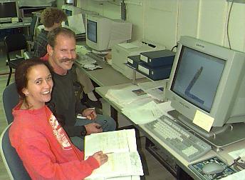
|
Ship's Senior Survey Technician, Jonathan Shannahoff and Scientist Susan Merle (Vents), operate the bathymetric mapping system (Sea Beam) during a mapping survey. The monitor shows the swath of bathymetry data as it is collected. (photo: NOAA Vents 1998) |
Meanwhile the ship time is still expensive and so we have moved north of our previous work area and are using SeaBeam to map some areas of the ocean floor that have not previously been carefully charted. Susan Merle, who has been a huge help in getting the material for these web pages put together, is responsible for much of the navigational data that is handled through the hydrolab. She and Jonathan are pictured here working with the SeaBeam. While our Imagenex system maps a swath about 70 meters wide in great detail, the SeaBeam collects data from a swath about 5000 meters wide at a much lower resolution. While collecting SeaBeam data is very important, we hope we don't end up doing too much of it because that means either ROPOS is disabled or the weather is bad.
For those of us who are infrequent visitors to the sea there is a danger of assuming that equipment and weather always cooperate as they have on this trip. Scientists who have been here often report that actually this performance by ROPOS has been absolutely spectacular, and up until the last 24 hours the weather has been superb. For those of you who have never been to sea, let me try to explain what the weather felt like this morning. If you can imagine being in your bunk with the bunk strapped to the top of a cheap carnival roller coaster for about 12 hours you have a pretty good idea of midnight to noon today. First you feel like you are nearly weightless and floating up off your bunk as the ship drops out from under you , and seconds later you are being pushed down through the mattress as the ship rides up over the next wave. All of this is accompanied by the sound of waves striking and the anchor bumping against the hull.
The science team met just a few minutes ago to go over plans for the next dive and to rough out a plan for the remaining two weeks of the expedition. The replacement pump seems to be doing its job on the fluid sampler (this was the part delivered by the Air Force), so that will be an important part of upcoming dives. We will also be returning to Ashes and, if time allows, scouting around for a new vent area of which we are seeing tantalizing hints in the analysis of water samples from out latest CTD samples. I may not have mentioned the Conductivity-Temperature-Density (CTD) sampler, but it is one of the most common tools used for sampling water.
It is nearly time for dinner, and since neither breakfast or lunch seemed like all that good an idea, I am definitely ready. If I haven't mentioned the galley staff yet, they are to be congratulated for serving excellent meals to upwards of 60 people three times a day. They are keeping us healthy and happy!
Logbook of all Teacher At Sea postings
Question/Answer of the Day
Send Your Question to NeMO
(oar.pmel.vents.webmaster@noaa.gov)
Back to Calendar