WHAT'S NEW:
Deepsea Image Galleries on Multimedia page
(posted 9/15/98)
Eruption Confirmed!
New lava (rumbleometer stuck in flow) SE rift zone
(posted 9/1/98)
BACKGROUND:
Technology (ROV, ships, etc.)
Other 1998 Axial cruise reports
EXPEDITION:
Science Objectives
Calendar
Today's Science News
Participant Perspective
Teacher Logbook
EDUCATION:
Curriculum
Teacher Observations
Questions/Answers from sea
MULTIMEDIA:
(video clips, animations, sounds)
DIVE PLAN
(VERY PRELIMINARY)
We don't know exactly what to expect after the January 1998 earthquake swarm on the summit and south rift zone of Axial. We know there has been a massive increase in thermal and chemical flux, and there is some evidence that an eruption may have taken place (possibly on the upper south rift zone in the southern part of the caldera).
The dive plan below is only preliminary, but it encompasses a complete survey of the geology, chemistry, and biology of all the known hydrothermal zones on the summit of Axial.
Since not all scientific instruments can fit onto the ROV ROPOS at the same time, scientists have made a straw plan showing what tasks can be done assuming 1 dive/day at the various locations.
| Dive # | Site | Goals |
Instrumentation
(see abbreviations) |
| 1 | ASHES | Chem/MicBi | FS/SUA |
| 2 | ASHES | Biol/Chem | BiBox/SUA/SS |
| 3 | So. Rift (Erupt. Area) | Geol./Mapping | DC/IS |
| 4 | So. Rift | Geol./Mapping | DC/IS | 5 | ASHES | Chem/MicBi | FS/SUA |
| 6 | ASHES | Biol/Chem | BiBox/SUA or SS |
| 6 | ASHES | Instrument Deploy, other | Elevator/HOBOS/LoTM/TLCam/OS |
| 7 | No. Rift | Mapping, Recover Extensometers | DC/IS/Elevator |
| 8 | ASHES/Wall | Geol./Mapping | DC/IS |
| 9 | So. Rift (Erupt. Area) | Chem/MicBi | FS/SUA |
| 10 | So. Rift (Erupt. Area) | Biol./Chem. | BioBox/SUA or SS |
| 11 | So. Rift (Erupt. Area) | Instrument Deploy, other | Elevator/HOBOS/LoTM/TLCam/OS |
| 12 | ASHES or So. Rift | Chem/MicBi | FS/SUA |
| 13 | ASHES or So. Rift | Biol./Chem | BioBox/SUA or SS |
| 14 | West Wall/Rift zone | Geol./Mapping | DC/IS |
| 15 | West Wall/Rift zone | Mapping, Geol. | DC/IS |
| 16 | West Wal/Rift zone | Chem./MicBi | FS/SUA |
| 17 | West Wall/Rift Zone | Biol./Chem | BioBox/SUA or SS |
| 18 | No. Rift | Deploy Extensometers, Map Vent | DC/IS |
| 19 | No. Rift/CASM | Mapping | DC/IS |
| 20 | ? | Chem./MicBi | FS/SUA |
| 21 | ? | Biol./Chem | BioBox/SUA or SS |
| 22 | ? | Chem./MicBi | FS/SUA |
| 23 | ? | Biol./Chem | BioBox/SUA or SS |
List of Instrument Abbreviations
| Abbreviation | Instrument | Purpose |
|---|---|---|
| FS | Fluid sampler | collects bottles of vent water for shipboard analysis |
| SUA | SUAVE chemical analyser | analyses fluid chemicals in situ |
| SS | Slurp Sampler | collects small bacterial/biological/water samples |
| OS | Osmosampler | collects small amounts of vent fluid continuosly over a year |
| BiBox | Biological Box | collection units for bringing animals to surface |
| TLCam | Time-lapse camera | deployed camera to document change over time |
| HOBOS | High-temperature probes | measures higher temperature fluids/samples |
| LoTM | Low-temperature probe | measures low-temperature fluids/samples | '
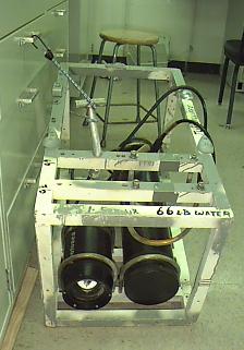
| DC | Digital Camera | camera storing images digitally |
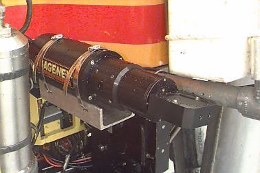
| IS | Imagenex scanning sonar | imaging system for sonar pictures of seafloor |
| Elevator | Sample elevator | mooring to transfer equipment to/from bottom |