WHAT'S NEW:
Deepsea Image Galleries on Multimedia page
(posted 9/15/98)
Eruption Confirmed!
New lava (rumbleometer stuck in flow) SE rift zone
(posted 9/1/98)
BACKGROUND:
Technology (ROV, ships, etc.)
Other 1998 Axial cruise reports
EXPEDITION:
Science Objectives
Calendar
Today's Science News
Participant Perspective
Teacher Logbook
EDUCATION:
Curriculum
Teacher Observations
Questions/Answers from sea
MULTIMEDIA:
(video clips, animations, sounds)
Logbook
September 16, 1998
September 16, 1998
Contents:
Science Report
Daily Science Report - Sep 16
ship's location = 45 55.9N/130 00.8W
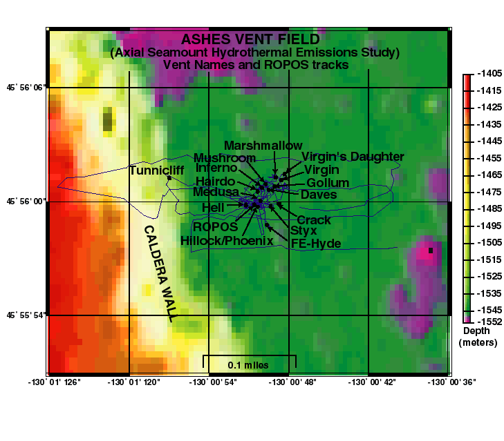
ROPOS is currently back at the ASHES vent field
(map left) on dive 479. The first
part of the dive consisted of fluid sampling of high-temperature vent fluids
(up to 293 deg C) at black smoker chimneys with names like "Hell", "Inferno",
and "Virgin Mound". This was followed by biological sampling with the
slurp sampler. We will also be finishing our
On the next dive we plan to redeploy the
acoustic extensometer instruments
on the north rift zone with the
elevator mooring, and then complete our Imagenex
sonar survey there. If time and weather permit, we may then visit a high-
temperature vent site on the north edge of Axial caldera called CASM. CASM was
the first vent site discovered on the Juan de Fuca Ridge, back in 1983 (15 years
ago!).
Listing of all Science News postings
Two weeks into my budding career with NOAA, twenty-five scientists embarked upon
the
first event response voyage to a volcanic eruption detected just north of
Axial Volcano on the Juan de Fuca ridge. Since that first cruise, one of my
duties at sea has been to aid in the navigation of vehicles, like ROPOS, along
the seafloor. You might be thinking to yourself, "Well that's easy, that's what
satellites are for!" Yeah, I used to think so too. Unfortunately, the water
acts as a barrier to such navigation, so we deploy instruments, called
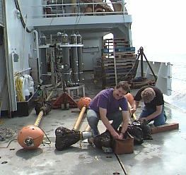
transponders (photo right shows Julia with a transponder), which are able to breach this barrier. Transponders are triggered
by and talk back with sound, and each has a unique frequency which identifies
it. Transponders look like bright yellow hard hats and are strung on a
200-meter-long tether anchored to the seafloor. Since we know the speed of
sound through water, we use the length of time the sound takes to travel through
the water and convert it into a distance, called a range.
Here's how the
process of setting up navigation on the seafloor works: First, three or more
transponders are deployed from the ship and drift down to the seafloor around
the area we wish to explore, and we call this a transponder net. Then the ship
drives around the area and ranges (sends and receives signals) to each of the
transponders and these ranges (computed from the travel time of the speed of
sound) are recorded in a special navigation program. Based on the various
ranges and knowing where the ship was when each of those ranges were received,
the program then determines where the transponders really landed on the
seafloor. Next, ROPOS is equipped with a relay transponder which can also talk
to the transponders as well as the ship. Again these travel times are converted
into distance and the navigation software triangulates these ranges to determine
the position of ROPOS within the net.
The ability to navigate instruments and
find locations on the seafloor has numerous purposes. One purpose is to do
time-series analysis. Time-series analysis in our case involves monitoring
sites on the Juan de Fuca Ridge from year to year to see how things are
changing, such as the water chemistry and temperature of hydrothermal vents, the
arrival or disappearance of new animals to an area, and the discovery of fresh
basalt. Therefore, excellent navigation helps us relocate these sites and is
crucial to the long-term study of mid-ocean ridges. Axial Volcano has been one
of those sites for many years and has proven to be a very exciting volcano to
watch!
In just a few days I will go back to Vanderbilt and continue studying
landslides on the Mid-Atlantic Ridge, but at night my dreams will most certainly
drift back to the Pacific, where a reliable crew, fantastic group of scientists
and the invincible ROPOS team once again made geologists, biologists, chemists
and physical oceanographers dreams come true.
Listing of all Perspectives postings
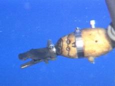
September 16 - 0900 hours
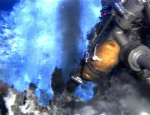
And there, firmly banded to the right arm of ROPOS is a potato. A potato?? Yes,
complete with a Mr. Potato-Head face painted on. And why, you ask, is there a
potato strapped to ROPOS this morning. We are sampling high temperature vents
this morning, and high temperature combined with high pressure equals quick
cooking. This is the principal behind every pressure cooker. Under pressure
the water reaches a higher temperature without boiling and so food cooks faster.
ROPOS has been on the bottom all night, and despite a couple of holes in the
filter system, samples are being collected from a number of very hot vents. The
chemists are concerned that the filter problems will invalidate their data for
some of the samples, but some of the information will be useful, and their
problem is now to determine which data are useful and which must be disregarded.
It's the same problem you have faced in science class when the teacher says,
"How confident are you about those results?" That's when you know you are going
to have to do something over again!.
1400 hours
ROPOS has completed the work on the bottom and will be doing
We caught some 20 knot winds in the last hour and were blown off station a
couple of times. Once ROPOS had to make a quick ascent to the cage since we
were drifting and within about 20 meters of the caldera wall. Caldera walls and
ROV's don't get along real well unless the meeting is planned. It took about
twenty minutes to put the ship back on station and then the last samples were
grabbed.
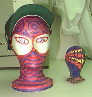
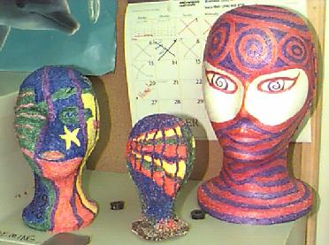
Some of you have undoubtedly figured out the head mystery. Imagine that you had
a cube of styrofoam exactly 1 inch on each side. If you were to step on that
cube and put your full weight on it, what would happen? Obviously it would be
crushed. If you weigh 140 pounds, you have just applied 140 pounds per square
inch to the styrofoam and it has collapsed. Now imagine that the pressure is
applied equally from all sides instead of just on the upper surface. Now the
styrofoam collapses equally in all directions. Instead of just being flattened,
it shrinks while maintaining roughly the shape of a cube. The ocean, at the
depths we are working, applies over one ton of pressure to each square inch of
the styrofoam head, and the head simply collapses. Since the air has been
forced out of the styrofoam, the head does not expand again as it is returned to
the surface. (photo above left)
One interesting thing that I did not notice when I photographed the heads was
the calendar on the wall behind them. (photo right) Obviously the folks in the microbiology
lab have some sort of countdown going on. It reminds me a lot of the calendar I
kept at the end of last year when I knew that retirement was 10, 9, 8, 7. .
.well, you get the idea. We are less than three days from firing up the engines
and steaming for Victoria. There is plenty of work to do between now and then,
but thoughts are definitely turning toward dry land.
We can't land until the cribbage tournament ends. Stay tuned to find out what
member of our group wasted way too much of his or her youth playing cards.
Logbook of all Teacher At Sea postings
Life at Sea: Participant Perspective
Julia Getsiv
Graduate Student,
Vanderbilt University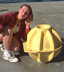 Hello! My name is Julia Getsiv and I am a graduate student working towards my
masters degree in geology at
Vanderbilt University. Although my thesis work is
in an area far, far away on a mid-ocean ridge in the Atlantic Ocean, my heart
and soul are still deeply linked to the
Juan de Fuca Ridge and
Axial Volcano. I
got my bachelors of science degree in geological oceanography five years ago and
immediately following began working for
Bob Embley as his research assistant.
Hello! My name is Julia Getsiv and I am a graduate student working towards my
masters degree in geology at
Vanderbilt University. Although my thesis work is
in an area far, far away on a mid-ocean ridge in the Atlantic Ocean, my heart
and soul are still deeply linked to the
Juan de Fuca Ridge and
Axial Volcano. I
got my bachelors of science degree in geological oceanography five years ago and
immediately following began working for
Bob Embley as his research assistant.
Teacher At Sea Logbook
 Mr. Potato-Head is being sent to the cooking pot 1550 meters below the surface
of the Pacific. I've got to say, scientists have just a bit of weird on them.
Mr. Potato-Head is being sent to the cooking pot 1550 meters below the surface
of the Pacific. I've got to say, scientists have just a bit of weird on them.
Question/Answer of the Day
Send Your Question to NeMO
(oar.pmel.vents.webmaster@noaa.gov)
Back to Calendar