NH-10
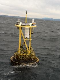
OA node at NH-10 off Newport, OR (44.6°N, 124.3°W)
The Newport Hydrographic (NH) line and NH-10 moorings are located in the northern California Current Ecosystem along the central Oregon coast. This region supports diverse and productive benthic and near shore ecosystems as well as economically important groundfish and crab fisheries. This area also experiences highly-variable biogeochemistry from Columbia River freshwater input and strong seasonal upwelling. The combination of upwelling and high productivity can lead to bottom water hypoxia, which makes this region a unique setting to track the combined impacts of ocean acidification (OA) and hypoxia on the biological system.
The OA node at NH-10 is located in the inner shelf at 85 m, within the region that experiences historical summer hypoxia. In April 2014, PMEL in collaboration with Dr. Burke Hales from Oregon State University deployed a suite of OA sensors on a surface buoy at NH-10. The OA observations at NH-10 are supported by NOAA's Ocean Acidification Program and also leveraged by existing activities on the NH line supported by the Northwest Association of Networked Ocean Observing Systems (NANOOS) and the Oceans Observatory Initiative (OOI) Endurance Array. For more information about complimentary projects at this location, see the OOI Endurance Array webpage. In June 2017 this site was discontinued and the buoy platform and sensors were moved to nearby Cape Arago, Oregon.
Finalized Data: National Centers for Environmental Information NCEI.
Plots of surface water and atmospheric CO2 and surface water pH:


