 |
COARE seacat information |
|
|||
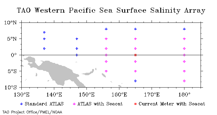
Moored Salinity Measurements during COARE Deployments typically were 6 to 12 months in length. In most cases sensors were calibrated before and after deployment. CTD casts near the moorings were also made for calibration purposes. Data quality analysis of the salinity records have indicated biases both linear and non-linear in time, which are due to electronic drift and biological fouling of the sensors. Quality indices associated with each measurement are included within the data files. Until such time as the actual quality indices can be applied, some data have been given nominal quality indices (2 for salinity and density, 1 for temperature). For the rest of the data the following indices have been used:
1 - pre-deployment calibrations used 2 - pre- and post-deployment calibration used (linearly interpolated in time) 3 - data adjusted after comparison with co-located Seacats or CTD casts 9 - other (details will be supplied) Density records have quality indices identical to those of their corresponding salinity records. Seacats measure and record instantaneous values of temperature and conductivity. The time between samples varied from 5 and 60 minutes. From these values (and the depth of the instrument) salinity and density (sigma-theta) were computed. Hourly values (made available here) were computed by averaging blocks of 1 to 12 instananeous values. Time indicated in the data files is the start of the averaging interval. At each site, separate files of hourly temperature, salinity and density are available. Header records within the files indicate number of records, time periods and depths of instruments. When the number of instruments or their depths change a new set of header records will appear. Fortran code for reading these files are also available. For more detailed information about these salinity data see the following publications:
Cronin, M. F. and M. J. McPhaden, 1998: Upper ocean salinity balance in the western equatorial Pacific. J. Geophys. Res., 103, 27,567-27587. Moorings have on occasion broken free from their anchors and drifted from their deployed location while still recording data. Daily mooring locations can be found in the corresponding TAO daily met data files which are available on the TAO Data Delivery Page. For example, to find the locations for the mooring at 0,165E, refer to the file 0n165e.met in the DailySurface category. Care should be used in the interpretation of the subsurface values during these events since the sensor depths are not accurately known. Information on buoys that have drifted is listed in the file taodata/hourly/drifters.doc.
Questions regarding data within this archive should be directed to: H. Paul Freitag,
paul.freitag at noaa.gov |
| Home | Project overview | Data display | Data delivery | El Niño & La Niña | Site map |
|
TAO
Project Office |