 |
Time-Longitude gridding |
|
|||
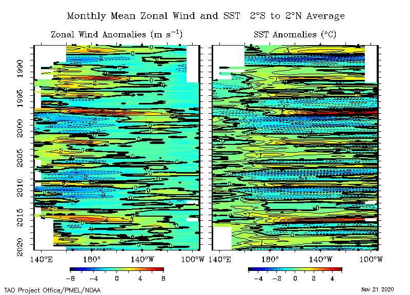
All of the fields displayed as time-longitude sections are fields of gridded 5-day or monthly means. The same gridding routine is used for all time-longitude fields. First, 5-day or monthly mean values are computed at the TAO/TRITON buoy array coordinates. Second, anomalies are computed from these by subtracting interpolated climatological averages from the data means. In the case of 5-day fields, the climatology is also interpolated linearly in time to the data times. Third, the means and anomalies are smoothed in time using a binomial (1/4 - 1/2 - 1/4) filter. Fourth, both the means and anomalies are gridded separately using the pplus routine zgrid, which uses a mixture of Laplacian and Bicubic interpolation. Finally, smoothed and gridded means and anomalies are masked using a linearly interpolated field computed from the the ungridded data. This allows liberal interpolation in longitude, but more limited interpolation in time over gaps no larger than 6 time steps. The original locations of data at the beginning and ending of the time series are shown by the little boxes on the horizontal axes, and choosing the Sampling option will show in detail what data are input into the zgrid. |
| Home | Project overview | Data display | Data delivery | El Niño & La Niña | Site map |
|
TAO
Project Office |