While many environmental features have been well documented (e.g., Schumacher and Stabeno, 1998; Stabeno et al., 2001; Hunt et al., 2002), temporal and spatial variations in the amount of solar radiation and its potential impact on ecosystem dynamics has not been well addressed, yet such variations are evident in time series of net short wave radiation (Fig. 30.3). The effect of latitude is apparent in these time series, with the northernmost station receiving approximately 19% less energy. The other two net short-wave radiation time series, which are at similar latitudes, appear coherent. The northern and the two southern time series show similar patterns of variability in 1972–1983 and 1995–2001. During the intervening period the time series appear to be out of phase by ~180 degrees with the magnitude of variability of the northern series much less than that seen in the southern time series. While the two series at approximately the same latitude are often similar in magnitude, there are some years (e.g., 1995) when they differ by more than 10 Wm![]() . Some of the longer-term variation may be due to the sun spot cycle that results in a solar flux variation of ~0.1% or ~2 Wm
. Some of the longer-term variation may be due to the sun spot cycle that results in a solar flux variation of ~0.1% or ~2 Wm![]() at sea level. It is likely, however, that regional differences in cloud cover account for the majority of this signal. It is not presently known how these differences influence ecosystem dynamics, although the latitudinal differences relate to a shorter more intense period of production over the northern shelf than exists over the southeastern shelf. This likely contributes to the observed differences in the dominant pathway of carbon cycling (pelagic versus benthic): the northern shelf is predominately a benthic system, whereas the southeastern shelf may be either pelagic or benthic depending on timing of spring blooms (Walsh and McRoy, 1986; McRoy, 1993).
at sea level. It is likely, however, that regional differences in cloud cover account for the majority of this signal. It is not presently known how these differences influence ecosystem dynamics, although the latitudinal differences relate to a shorter more intense period of production over the northern shelf than exists over the southeastern shelf. This likely contributes to the observed differences in the dominant pathway of carbon cycling (pelagic versus benthic): the northern shelf is predominately a benthic system, whereas the southeastern shelf may be either pelagic or benthic depending on timing of spring blooms (Walsh and McRoy, 1986; McRoy, 1993).
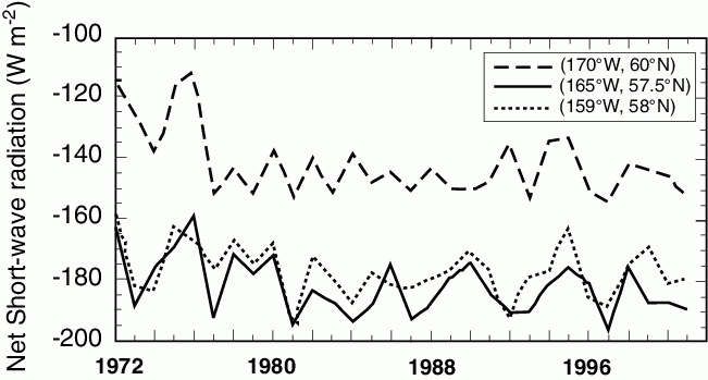
Figure 30.3: Average net short wave radiation (NSWR) from April 1–June 30 (Wm![]() ). Note negative indicates a downward flux.
). Note negative indicates a downward flux.
Recent research (e.g., Minobe, 1999, 2002; Hare and Mantua, 2000) has highlighted atmospheric variations that exist on multi-decadal time scales (typically, 10 to 70 years), which cause significant alterations throughout the ecosystem. These changes, known as regime shifts, are seen in the biological environment primarily as changes in community composition and/or biomass of a given species. The mechanisms that initiate a climate regime shift, however, are presently unknown. In a review of how climate variability impacts biota in the eastern Bering Sea, Schumacher and Alexander (1999) identify the following four candidates for forcing interdecadal signals in that region. First, changes in solar activity are correlated with temperature and pressure in the atmosphere over the North Pole (Labitzke and van Loon, 1988), and may provide a forcing mechanism for decadal oscillations in the coupled air-ice-sea system in the northern hemisphere (Ikeda, 1990). The lunar nodal cycle of the moon (period of 18.6 yrs) affects mixed layer depths and has been linked to oceanic conditions in the North Pacific Ocean (Royer, 1998; Royer et al., 2001). Third, atmospheric interactions exist between the Southern Oscillation and the Aleutian Low as proposed by Wooster and Hollowed (1995). Finally, Latif and Barnett (1994) suggest that an unstable air-sea interaction exists between circulation in the North Pacific subtropical gyre and the Aleutian Low pressure system. Since 1999, other candidates have been proposed, including changes in mid-latitude wind stress (Parrish et al., 2000), subtropical oceanic Rossby waves (Jin et al., 2001), and subsurface changes in the ocean south of the equator as part of an oscillation intrinsic to the equatorial and southern tropical Pacific Ocean (Giese et al., 2002).
The primary atmospheric pressure features influencing the Bering Sea include weather patterns in the tropical South Pacific (El Niño-Southern Oscillation: ENSO), North Pacific (Pacific-North America: PNA) and Arctic (Arctic Oscillation: AO). The mode of connectivity between these hemispheric-scale features and the regional weather appears to be mainly a perturbation in the magnitude, pathway, and frequency of storm passage along the Aleutian Island chain (Stabeno et al., 1999). The frequent migration of storms results in a statistical feature known as the Aleutian Low. During summer with its long periods of daylight and high solar radiation, the Aleutian Low is typically weak and the weather benign. During winter, a marked change occurs in atmospheric pressure fields. High sea level pressure (Siberian High) dominates Asia, while the Aleutian Low deepens and dominates weather over the North Pacific and Bering Sea. The juxtaposition of these features results in strong, frigid winds from the northeast. The frequency and intensity of storms in the southern Bering Sea decreases temporally from winter to summer, but the frequency also decreases with increasing latitude (Overland, 1981; Overland and Pease, 1982).
The physical features of the oceanic and shelf region of the eastern Bering Sea were reviewed by Schumacher and Stabeno (1998) and Stabeno et al. (1999). Over the southeastern shelf during summer, three distinct cross shelf domains exist which are characterized by water column structure, currents and biota (Cooney and Coyle, 1982; Coachman, 1986; Schumacher and Stabeno, 1998). These are the coastal (depth <50 m and characterized by weak stratification), middle shelf (50–100 m deep, characterized by a wind-mixed surface layer abutting a tidally mixed bottom layer), and outer shelf (100–180 m deep, mixed upper and lower layers separated by a layer with slowly increasing density). Over much of the southeastern shelf during summer, temperature is an excellent indicator of vertical water-column structure. The primary source of freshwater is the melting of sea ice; the sea ice is advected southward during the winter and early spring. During early spring, the combination of tidal and wind mixing tend to weaken any strong halocline. For waters <30 m deep, tidal mixing energy tends to stir the entire water column. In the deeper waters (30 < z < 90 m), there is some vertical structure in salinity, but it is typically <0.3 psu (Overland et al., 1999b). It is only in late spring and summer when the storms weaken and solar heating begins, that pronounced vertical stratification occurs over the middle domain. During winter, the domains are poorly defined since storms mix the water column to >90 m.
These summer (April-October) domains are separated by a system of transitional zones or fronts (Coachman, 1986; Iverson et al., 1979; Schumacher and Stabeno, 1998). The shelf-break front separates the outer shelf from slope waters; the broad middle shelf transition zone lies between outer and middle shelf waters; and an inner (structure) front separates the well-mixed coastal waters and the two-layered middle shelf domain. Knowledge of the characteristics of the inner front was recently refined: the inner front is wider than previously thought and its location varies by tens of kilometers (Kachel et al., 2002), rather than being relatively fixed to the 50-m isobath as earlier hypothesized. The balance of wind and tidal energy plays a major role in shaping the vertical structure of both the coastal and middle shelf domains (Schumacher and Stabeno, 1998; Coachman, 1986). The domains provide unique habitats for biota. For example, the meso-zooplankton community in the two shallower domains is comprised primarily of the small to medium-sized copepods, whereas in the outer shelf domain and oceanic region, large copepods dominate (Cooney and Coyle, 1982; Smith and Vidal, 1986).
We consider the northern shelf to be that portion of the eastern shelf north of ~62°N where changes in topography, tidal energy, and river discharge (primarily from the Yukon River) modify the boundaries between domains. The width of both the coastal and middle shelf domains increase. Nearly the entire shelf east of the Anadyr Strait has depths <50 m, and much of the Gulf of Anadyr lies in the middle domain. North of Nunivak Island, the inner front moves to the vicinity of the 30-m isobath as tidal mixing energy decreases (Schumacher and Stabeno, 1998). In the vicinity of the Yukon River delta, however, the substantial freshwater discharge can result in stratification in waters <30 m. The water column (generally <20 m) in Norton Sound typically exhibits a two-layered structure during summer as opposed to the coastal domain in the southeast, which is at most weakly stratified. During winter, strong heat and salt fluxes result in a vertically mixed water column (Muench et al., 1981).
Across the shelf south of St. Lawrence Island, three water masses exist: Alaskan Coastal, Bering Shelf, and Anadyr (Coachman et al., 1975). The accompanying regional salinity field is characterized by a zonal gradient with salinity decreasing from east to west (Coachman et al., 1975; Schumacher et al., 1983). In water where the temperature is <0°C, the salinity between ~30 to 60 m increases by 2.5 psu from east to west across the shelf. During ice-free conditions, salinity from St. Lawrence Island to the Gulf of Anadyr seldom exceeds 32.8 psu; however, during ice formation values >34.2 psu occur. In the Gulf of Anadyr, salinity during summer ranges between 33.0 and 33.5 psu. The saline waters which flow northwestward across the mouth of the Gulf of Anadyr carry relatively warm temperatures and nutrients which suggests the presence of outer shelf water. North of St. Lawrence Island, all three water masses are present and can be identified as they flow northward through Bering Strait (Coachman et al., 1975).
A system of three hydrological zones exists over the western shelf that are somewhat analogous to those found on the eastern shelf (Verkhunov, 1994). These hydrological zones (coastal, transitional and oceanic) are easily distinguished in temperature/salinity diagrams (Khen, 1999). The coastal zone has low (<31.0 psu) salinity surface water and a strong pycnocline. Due to a less pronounced halocline, the transitional zone exhibits a more weakly two-layered structure than the coastal zone. In both zones, a strong seasonal thermocline develops over summer. The oceanic zone is identified by a three-layered vertical structure with relatively warm (~1.0°C) bottom temperatures that indicate the presence of slope waters.
While there is some similarity to the hydrographic structure of the eastern shelf, fundamental differences exist. The locations of the zones over the western shelf are not stationary, although they can at times be associated with depth contours as occurs on the eastern shelf (Verkhunov, 1994). The western shelf is relatively narrow and divided by peninsulas into three separate and somewhat isolated gulfs. The immense width of the eastern shelf eliminates the direct influence of gyre circulation on all but the outer domain. Such is not the case on the western side, where the Kamchatka Current, the western boundary current of the Bering Sea gyre, has a profound impact on the location of hydrographic zones. When this current moves shoreward and flows over the continental slope, all the zones are compressed and their frontal divisions are shifted shoreward (Khen, 1999).
A schematic of the general circulation is shown in Fig. 30.4. The portion of the Alaskan Stream that flows through Aleutian passes, especially Amchitka and Amukta Passes, forms the eastward flowing Aleutian North Slope Current (ANSC: Reed and Stabeno, 1999; Stabeno et al., 1999). The ANSC provides the main source of the Bering Slope Current (BSC), which is often characterized as variable flow replete with eddies and meanders, although at times it appears as a more organized northwestward flowing current (Stabeno et al., 1999). The BSC separates from the slope, resulting in a broad weak westward flow across the basin. Along the west coast the current intensifies, forming the southward flowing Kamchatka Current. Exchange between the slope and eastern shelf likely varies depending upon which mode of the BSC is dominant. Transport in the ANSC/BSC system is highly variable ranging from ~2 × 10![]() m
m![]() s
s![]() to ~9 × 10
to ~9 × 10![]() m
m![]() s
s![]() (Stabeno et al., 1999). The importance of these slope currents to ecosystem dynamics of the eastern shelf is threefold. First, they transport material northward along the slope that can be advected onto the shelf through various onshelf mechanisms (Schumacher and Stabeno, 1994; Stabeno et al., 2001). Second, eddies, which are common seaward of the shelf break (Schumacher and Reed, 1992), apparently provide a temporary habitat that favors survival of larvae (Schumacher and Stabeno, 1994) and are regions of enhanced primary production (Mizobata et al., 2002). Finally, the vertical temperature structure of the slope current with its warm subsurface maximum is potentially important to fish stocks (Reed, 1995).
(Stabeno et al., 1999). The importance of these slope currents to ecosystem dynamics of the eastern shelf is threefold. First, they transport material northward along the slope that can be advected onto the shelf through various onshelf mechanisms (Schumacher and Stabeno, 1994; Stabeno et al., 2001). Second, eddies, which are common seaward of the shelf break (Schumacher and Reed, 1992), apparently provide a temporary habitat that favors survival of larvae (Schumacher and Stabeno, 1994) and are regions of enhanced primary production (Mizobata et al., 2002). Finally, the vertical temperature structure of the slope current with its warm subsurface maximum is potentially important to fish stocks (Reed, 1995).
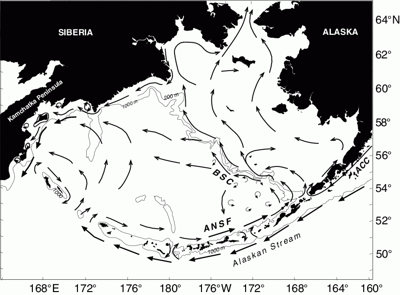
Figure 30.4: Schematic of mean circulation in the upper 40 m over the basin and shelf (from Stabeno et al., 1999). The arrows with large heads represent currents with mean speeds >50 cm s![]() . The Alaskan Stream, Aleutian North Slope Current (ANSC), Bering Slope Current (BSC) and Kamchatka Current are indicated. Depth contours indicate 1000 m isobath and in the Bering Sea the 200 m isobath.
. The Alaskan Stream, Aleutian North Slope Current (ANSC), Bering Slope Current (BSC) and Kamchatka Current are indicated. Depth contours indicate 1000 m isobath and in the Bering Sea the 200 m isobath.
Low frequency flow on the shelves is much weaker than in the basin. Over the eastern shelf, the net flow from late spring through mid autumn is northward. Enhanced, more organized flow occurs along the 100 m isobath and the 50 m isobath. Both of these coincide with frontal or transition zones on the shelf. The flow along the 50 m isobath, which we call the Bering Coastal Current (BCC), is weak (1–5 cm s![]() ). The BCC consists of waters from the Gulf of Alaska's Alaska Coastal Current (ACC) that flows through Unimak Pass with a transport of ~0.3 × 10
). The BCC consists of waters from the Gulf of Alaska's Alaska Coastal Current (ACC) that flows through Unimak Pass with a transport of ~0.3 × 10![]() m
m![]() s
s![]() (Schumacher and Stabeno, 1998; Stabeno et al., 2002). Some of this transport flows along the Alaska Peninsula and the west coast of Alaska where freshwater is added from widely distributed riverine sources. Unlike other buoyancy driven flows that are strengthened and compressed to the coastline by alongshore wind stress (e.g., the ACC; Stabeno et al., 1995), the BCC is strongest in the vicinity of the 50 m isobath, which can be more than 100 km offshore (Schumacher and Stabeno, 1998; Schumacher and Kinder, 1983). After flowing around the entire perimeter of the eastern shelf, the BCC exits the Bering Sea through Bering Strait.
(Schumacher and Stabeno, 1998; Stabeno et al., 2002). Some of this transport flows along the Alaska Peninsula and the west coast of Alaska where freshwater is added from widely distributed riverine sources. Unlike other buoyancy driven flows that are strengthened and compressed to the coastline by alongshore wind stress (e.g., the ACC; Stabeno et al., 1995), the BCC is strongest in the vicinity of the 50 m isobath, which can be more than 100 km offshore (Schumacher and Stabeno, 1998; Schumacher and Kinder, 1983). After flowing around the entire perimeter of the eastern shelf, the BCC exits the Bering Sea through Bering Strait.
While some of the transport through Unimak Pass forms the BCC, the remainder flows northwestward in the vicinity of the 100 m isobath to the Pribilof Islands. The strongest mean current over the central and southeastern shelf is found south of St. George Island, where the outer shelf narrows and the bottom slope increases and thus narrowing the flow along the 100 m isobath. Daily average currents can exceed 40 cm s![]() . The mean flow over the rest of the central and southeastern shelf is weak (generally <5 cm s
. The mean flow over the rest of the central and southeastern shelf is weak (generally <5 cm s![]() ). The currents over the northern shelf are stronger, especially the Anadyr Current which is the primary source of water flowing through Bering Strait. During winter, the flow becomes less organized over the shelf as the frontal structures break down and strong winter storms mix the water to the bottom.
). The currents over the northern shelf are stronger, especially the Anadyr Current which is the primary source of water flowing through Bering Strait. During winter, the flow becomes less organized over the shelf as the frontal structures break down and strong winter storms mix the water to the bottom.
Tidal currents are a major circulation feature of the southeastern shelf, but over the northern and western shelves their importance is greatly diminished (Schumacher and Stabeno, 1998; Stabeno et al., 1999; Kowalik and Stabeno, 1999). Over the southeastern shelf, tides are the dominant source of kinetic energy and they typically mix the coastal waters (z < ~50 m) and the lower 30–40 m of the deeper portions of the shelf. In addition, their interaction with bathymetric features can result in residual flow, particularly in canyons (Schumacher and Reed, 1992; Kowalik and Stabeno, 1999) and around islands such as the Pribilof Islands (Kowalik and Stabeno, 1999; Stabeno et al., 1999).
The eastern Bering shelf is a marginal ice zone, and sea ice markedly impacts the ecosystem. Ice-free conditions typically exist from June through October. Formation of sea ice generally begins in the polynyas of the northern shelf in November, with maximum ice extent occurring as early as January or as late as April, but more typically in March. The mechanism of ice formation for the eastern Bering Sea has been described by analogy to a "conveyor belt" (Overland and Pease, 1982). Ice is produced along leeward (south-facing) coasts of the northern shelf, and is driven southward by wind to the vicinity of its thermodynamic limit where it melts. This limit advances southward as cold northerly winds and ice-melt cool the shelf waters. The amount of production and advection of ice depends upon which storm track dominates, with greatest ice production occurring in years when the Aleutian Low is well developed and displaced eastward so that storms migrate along a primary storm track south of the Alaska Peninsula. Satellite observations of ice cover show ~40% variation about the mean (Niebauer, 1998). Using the same sea ice data set, but resolved along a longitude, Wyllie-Echeverria (1995) showed that other characteristics also exhibit large interannual variability. These characteristics include: duration of ice at its southern extent (3–15 weeks), time of retreat from the southernmost extent (between February and June), and the number of weeks that ice remained over the middle shelf (3–28 weeks, with a mean of 20).
Changes in characteristics of sea ice over the southeastern shelf (including the time of arrival, departure and persistence), indicate that the most extensive ice years coincided with the negative phase of the Pacific Decadal Oscillation (the first mode of decadal variability in sea surface temperature over the North Pacific Ocean), although considerable interannual variability occurs (Stabeno et al., 1998 and 2001). These authors characterized temporal variability in spatial patterns by dividing the time series of ice observations into three subsets according to generally agreed upon periods: 1972–76 (cold), 1977–88 (warm), and 1989–98 (weaker cold). A marked difference exists in persistence and spatial distribution of ice between the first and the latter two periods. During the cold period, ice covered the shelf out to and over the slope, and remained around St. Paul Island for more than a month. During the later years, ice did not extend as far seaward and its residence time was typically 2–4 weeks less than during the cold period. The differences between the two latter regimes are more subtle, but still evident. Between the mid-shelf and slope northwest of the Pribilof Islands, ice remained for 2–4 weeks longer during 1989–1998 than during 1977–1988. North and west of St. Lawrence Island and along the coast of Alaska north of Kuskokwim Bay, there were 1–2 less weeks of ice cover in 1989–1998 than in 1977–1988. Changes in the Arctic Oscillation and the attendant changes in wind patterns are likely the causal mechanism for these recent alterations in sea ice (Stabeno and Overland, 2001). In addition, marked differences existed in the ice distribution and extent along the Alaskan Peninsula. During the cold period, ice extended seaward nearly to Unimak Pass, whereas in the other periods contours of ice persistence were constrained or limited to inner Bristol Bay. This pattern is likely related to variations of inflow and/or temperature of shelf waters from the Gulf of Alaska, which flows through Unimak Pass onto the Bering Sea shelf (Schumacher and Stabeno, 1998).
Cold northerly winds, which advect the ice southward, and melting play a critical role in fluxes of heat and salt, and in generation of both baroclinic flow and the cold lower layer (cold pool) which persists all summer over the middle shelf domain (Schumacher and Stabeno, 1998; Wyllie-Echeverria and Ohtani, 1999). The positive buoyancy from melting ice initiates both baroclinic transport along the marginal ice zone and stratification. Cooling and mixing associated with ice-advance help to condition the entire water column over the middle shelf domain (Stabeno et al., 1998). With subsequent seasonal heating of the upper layer, the lower layer becomes insulated and temperatures often remain below 2°C (Reed, 1995). The annual area of this cold pool varies by ~2.0 × 10![]() km
km![]() between maximum and minimum extent.
between maximum and minimum extent.