U.S. Dept. of Commerce / NOAA / OAR / PMEL
/ Publications
On the temporal variability of the physical environment over the south-eastern Bering Sea
P. J. Stabeno,1 N. A. Bond,2 N. B. Kachel,2 S. A. Salo,1
and J. D. Schumacher3
1NOAA, Pacific Marine Environmental Laboratory, Seattle,
Washington, 98115
2University of Washington, JISAO, Seattle, Washington, 98195
3Two Crow Environmental Consultants, Silver City, NM, 88061
Fisheries Oceanography, 10(1), 81–98
(2001).
Copyright ©2001 by Blackwell Science Ltd. Further electronic distribution
is not allowed.
CURRENTS
Currents can be divided into high-frequency tidal currents and lower-frequency
flows. Most of the horizontal kinetic energy over the south-eastern shelf is
in the tidal currents; they play an important role in mixing and generation
of subtidal flow owing to their non-linear interaction with topographic features
(Stabeno
et al., 1999). Over the south-east shelf the dominant tidal constituent
is M , which has an amplitude of
~24 cm s
, which has an amplitude of
~24 cm s at Site 2 and ~20 cm s
at Site 3. The dominant diurnal tide is K
at Site 2 and ~20 cm s
at Site 3. The dominant diurnal tide is K with tidal speeds about half of M.
In general, the annual mean flow is <5 cm s
towards the north-west, following bathymetry (Fig. 12). The strongest flow on
the shelf occurs at the shelf break and along the Alaskan Peninsula. The mean
flow in the centre of the shelf, near Site 2, is weak. Water from the western
Gulf of Alaska enters the shelf through Unimak Pass and continues to flow along
either the 50 m or 100 m isobath. This flow accounts for about one-third of
the flow through Bering Strait (0.35 × 10
with tidal speeds about half of M.
In general, the annual mean flow is <5 cm s
towards the north-west, following bathymetry (Fig. 12). The strongest flow on
the shelf occurs at the shelf break and along the Alaskan Peninsula. The mean
flow in the centre of the shelf, near Site 2, is weak. Water from the western
Gulf of Alaska enters the shelf through Unimak Pass and continues to flow along
either the 50 m or 100 m isobath. This flow accounts for about one-third of
the flow through Bering Strait (0.35 × 10 m3 s). The flow along the 100
m isobath is enhanced by flow up Bering and Pribilof Canyons, which also provide
on-shelf transport of nutrients and salt (Stabeno
et al., 1999). A weak cross-shelf flow north of the Pribilof Islands
transports nutrient-rich waters to the inner shelf region.
m3 s). The flow along the 100
m isobath is enhanced by flow up Bering and Pribilof Canyons, which also provide
on-shelf transport of nutrients and salt (Stabeno
et al., 1999). A weak cross-shelf flow north of the Pribilof Islands
transports nutrient-rich waters to the inner shelf region.

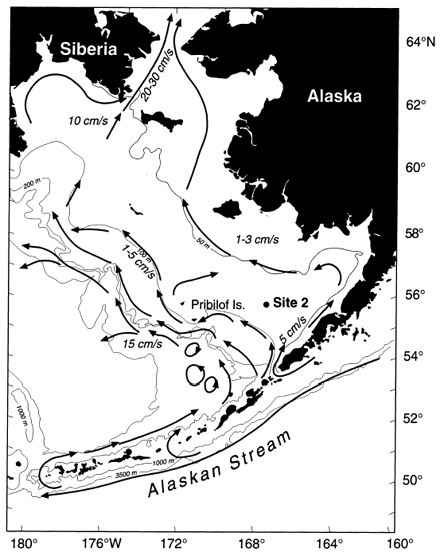
Figure 12. A schematic of flow on the eastern Bering Sea shelf in the
upper 40 m of water column generated from a synthesis of moored current meters,
satellite-tracked drift buoys and inferred geostrophic flow. Depths are in metres.
(After Schumacher
and Stabeno, 1998; Stabeno
et al., 1999).
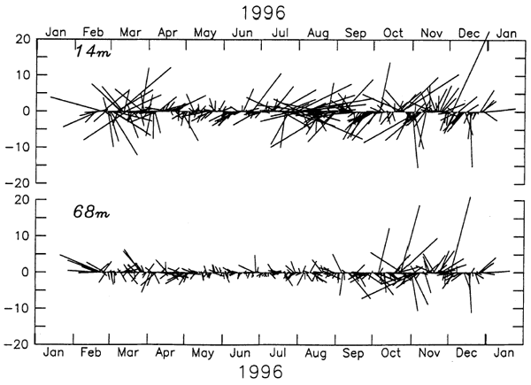
Long-term current measurements over the south-east Bering Sea shelf do not
exist, except for 34 months of noncontinuous current data at Site 2. The longest
continuous record was collected during 1996 with an acoustic Doppler current
profiler (ADCP) (Fig. 13). A 35-hour Lanczos squared filter was applied to each
of the time series to remove tidal and other high-frequency variability. Great
variations in direction and amplitude of the low-frequency currents are evident,
with stronger flow near the surface. These time series are representative of
all velocity records at this location. Statistics (Tables 2 and 3) provide the
mean monthly velocity and kinetic energy (calculated from these low-pass-filtered
data). Site 2 is in an area of weak mean currents, but currents averaged over
a shorter time scale (i.e. daily) can exceed 25 cm s. Throughout the year, the strongest flow occurred
in the upper water column, with weakest currents near the bottom. There was
a marked seasonal signal, with the most energetic currents occurring during
the winter and the weakest currents during the summer. The average velocity
over the 34 months of these records is 1.2 cm s to the west at a depth of 15 m and 0.2 cm s to the north-west at a depth of 60 m.
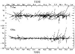
Figure 13. Time series of low-pass filtered currents as measured at
Site 2 at (a) a depth of 14 m and (b) near the bottom at a depth of 68 m.
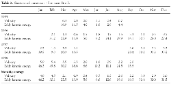
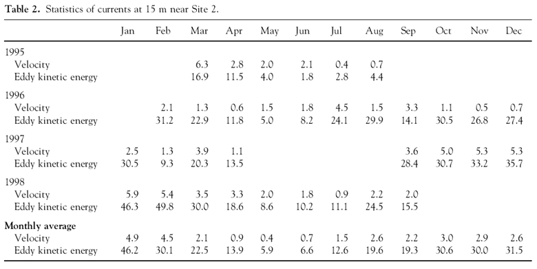
Table 2. Statistics of currents at 15 m near Site 2.
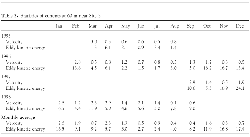
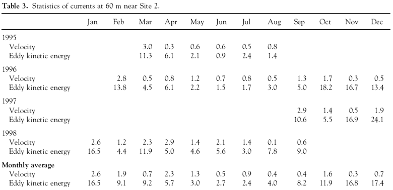
Table 3. Statistics of currents at 60 m near Site 2.
The strong winds during winter and spring 1998 forced stronger-than-average
currents on the middle shelf. This flow during the winter likely resulted in
strong cross-shelf transport of nutrients and salt, which would explain the
observations of oceanic organisms along the Alaskan coast during May and the
replenishment of salt at Site 2. In contrast, 1997 had particularly weak flows,
as evidenced by the satellite-tracked drifting buoys that were deployed in the
area during the spring and summer. Earlier research (Coachman,
1986) had concluded that because the mean flow over the middle shelf was
weak, these currents would not play a role in replenishing nutrients and salt.
Our ocean current records show that although annual and longer-term current
velocities are weak, monthly mean currents can be persistent and can easily
replenish nutrients and salt.
Return to previous section or go to the next
section
PMEL Outstanding Papers
PMEL Publications Search
PMEL Homepage