U.S. Dept. of Commerce / NOAA / OAR / PMEL / Publications
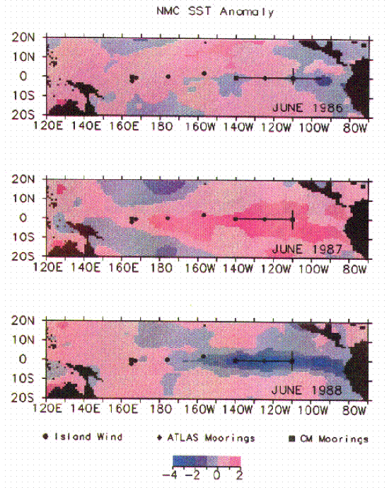
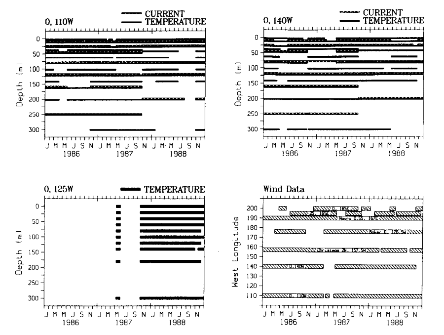
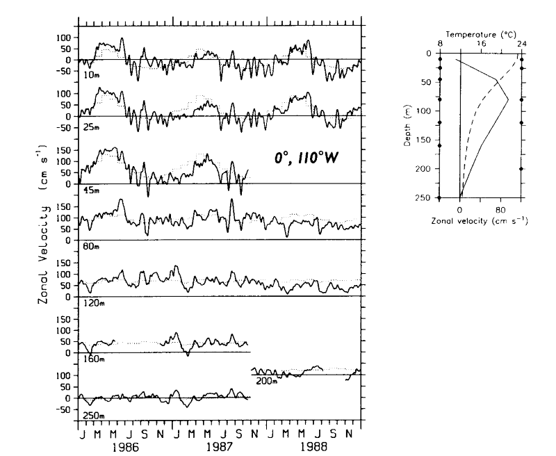
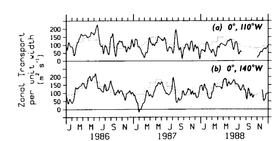
The moored time series used in this study consist of current, temperature, and wind data from the locations shown in Plate 1. These measurements were made from taut wire surface mooring at depths ranging from 3 to 5 km. The lengths of the moored time series and depths instrumented for the period 1986-1988 are shown in Figure 1. The number of depths instrumented with current meters was reduced from seven to five in boreal fall 1987 in response to changing scientific priorities. Typically, six additional depths were instrumented with SeaData temperature recorders (TRs). Data gaps during 1986-1988 were filled where appropriate according to procedures outlined in Appendix A in order to facilitate analysis. The data distribution for times prior to 1986 (used to generate Plate 2 and to compile mean seasonal cycles, as discussed in Appendix B) is given by Halpern [1987a], Halpern et al. [1988], and McPhaden and Taft [1988].
Figure 1. Record lengths of daily time series from moorings and island wind stations.
The current meter moorings were equipped with EG&G model 610 vector averaging
current meters (VACMs) and vector measuring current meters (VMCMs) in the upper
250 m. The difference between VACM and VMCM measurements is generally <5
cm s [Halpern,
1987b], so for the purposes of this study they can be considered
as interchangeable. Temperature and velocity data were recorded at 15-min intervals
and then processed to daily averages. Instrumental accuracy of the VACM and
TR temperature sensors is approximately 0.01°C and 0.05°C, respectively. SST
is measured 1 m below the surface using either a Yellow Springs Instrument (YSI)
model 44032 temperature sensor (calibrated accuracy of 0.01°C) or a YSI model
44204 temperature sensor (calibrated accuracy of 0.05°C). Additional information
on the processing of data from equatorial current meter mooring is given by
Freitag
et al. [1987].
[Halpern,
1987b], so for the purposes of this study they can be considered
as interchangeable. Temperature and velocity data were recorded at 15-min intervals
and then processed to daily averages. Instrumental accuracy of the VACM and
TR temperature sensors is approximately 0.01°C and 0.05°C, respectively. SST
is measured 1 m below the surface using either a Yellow Springs Instrument (YSI)
model 44032 temperature sensor (calibrated accuracy of 0.01°C) or a YSI model
44204 temperature sensor (calibrated accuracy of 0.05°C). Additional information
on the processing of data from equatorial current meter mooring is given by
Freitag
et al. [1987].
Winds from the equatorial current meter mooring were sampled 4 m above the
mean water line on the surface toroid with either a vector averaging wind recorder
(VAWR) or an Argos meteorological platform (AMP). The VAWR is an inverted VACM
equipped with a Climet cup model 011-2B three-cup anemometer and pivoted vane
[Freitag
et al., 1989]. The AMP was designed at Pacific Marine Environmental
Laboratory (PMEL) to transmit data in real time and is equipped with an R.M.
Young model 05103 propeller and vane. Predeployment and postdeployment calibrations
for the VAWR and AMP indicate expected instrumental errors in wind speed of
about 0.1 m s. Comparison of the two wind
systems in a field experiment near 0°, 140°W suggests that for our purposes
the cup and vane and the propeller and vane systems can be considered interchangeable
[Freitag
et al., 1989].
The 0°, 125°W and 2°S, 165°E moored data used in this study were collected with ATLAS (autonomous temperature line acquisition system) thermistor chains. ATLAS [Milburn and McClain, 1986] is a taut wire surface mooring which measures winds, air temperature, SST, and 10 subsurface temperatures to a maximum depth of 500 m. Winds are measured using an R.M. Young model 05103 propeller and vane assembly. Thermistors are calibrated prior to deployments to an accuracy of about 0.005°C; in situ comparisons with nearby conductivity-temperature-depth (CTD) casts indicate a long-term accuracy of better than 0.1°C. Data are telemetered to shore via Service Argos as 2-hour averages (or in some cases 1-hour averages). Normally, five unique data transmissions are received each day. The basic time series is taken to be daily averages of these data.
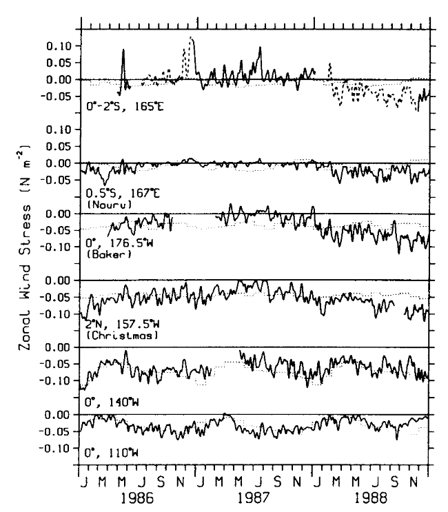
Winds are measured at Nauru (0°32 S, 166°54E),
Baker (0°12N, 176°29W),
and Christmas (1°59N, 157°29W)
islands from an R.M. Young model 05103 propeller and vane anemometer mounted
on a tower 10 m above the ground. Anemometers are replaced every 6 months to
1 year and are calibrated prior to deployment to within 0.2 m s.
Data are vector averaged for 40 min of each hour, and then three individual
hourly samples are transmitted to shore via GOES geostationary satellite. Data
are processed to daily means for this study.
S, 166°54E),
Baker (0°12N, 176°29W),
and Christmas (1°59N, 157°29W)
islands from an R.M. Young model 05103 propeller and vane anemometer mounted
on a tower 10 m above the ground. Anemometers are replaced every 6 months to
1 year and are calibrated prior to deployment to within 0.2 m s.
Data are vector averaged for 40 min of each hour, and then three individual
hourly samples are transmitted to shore via GOES geostationary satellite. Data
are processed to daily means for this study.
Nauru winds tend to underestimate the amplitude of variations at the 0°, 165°E mooring site during periods of westerlies [McPhaden et al., 1988, 1990a] when the wind sensor, located on the northeast side of the island, is in the lee of a 40-m hill. Nonetheless, there is a high correlation between daily time series at the two locations for the period December 1986 to October 1987 (0.88 for zonal winds and 0.85 for meridional winds), so that Nauru winds can be used as an index for winds at the mooring site during the ENSO event. Nauru winds are a more exact indicator of open ocean conditions during periods of easterlies as occurred during early 1986 and during 1988.
CTD data were collected from National Oceanic and Atmospheric Administration (NOAA) research vessels using a Neil Brown Instrument Systems Mark III CTD along the transacts indicated in Plate 1. Stations were occupied approximately every 5° of longitude and 1° in latitude during spring and fall cruises each year. Casts were made to at least 1000 dbar and processed to 1-dbar resolution. Lynch et al. [1988] describe the acquisition and processing of these data in greater detail.
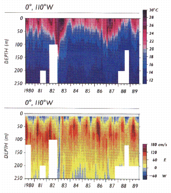
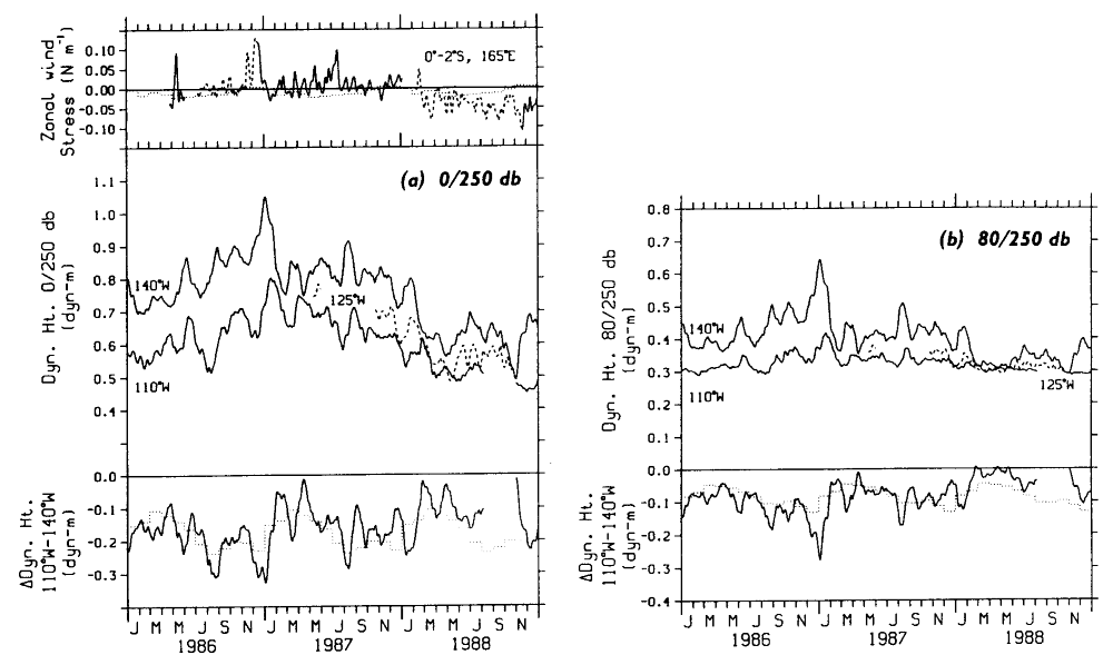
Moored temperature data were used to calculate surface dynamic height relative to 250 dbar. To estimate salinity in the dynamic height calculation, we used a mean temperature-salinity profile based on 17 CTDs at 125° and 140°W and 44 CTDs at 110°W. Figure 2 shows the dynamic height time series and individual dynamic height estimates based on eight CTD casts at 110°W and six CTD casts at 140°W. The rms difference between daily averaged dynamic heights estimated from moorings and from the hydrocast calculations is 1.0 dynamic centimeters (dyn. cm) (110°W) and 2.0 dyn. cm (140°W). These are comparable to the 0-/500-dbar rms differences found by Emery and Dewar [1982] from historical data. Also, 0-/250-dbar dynamic height variations at 110°W (140°W) were only 1% (2%) weaker than 0-/1000-dbar variations estimated from the eight (six) available CTD casts.
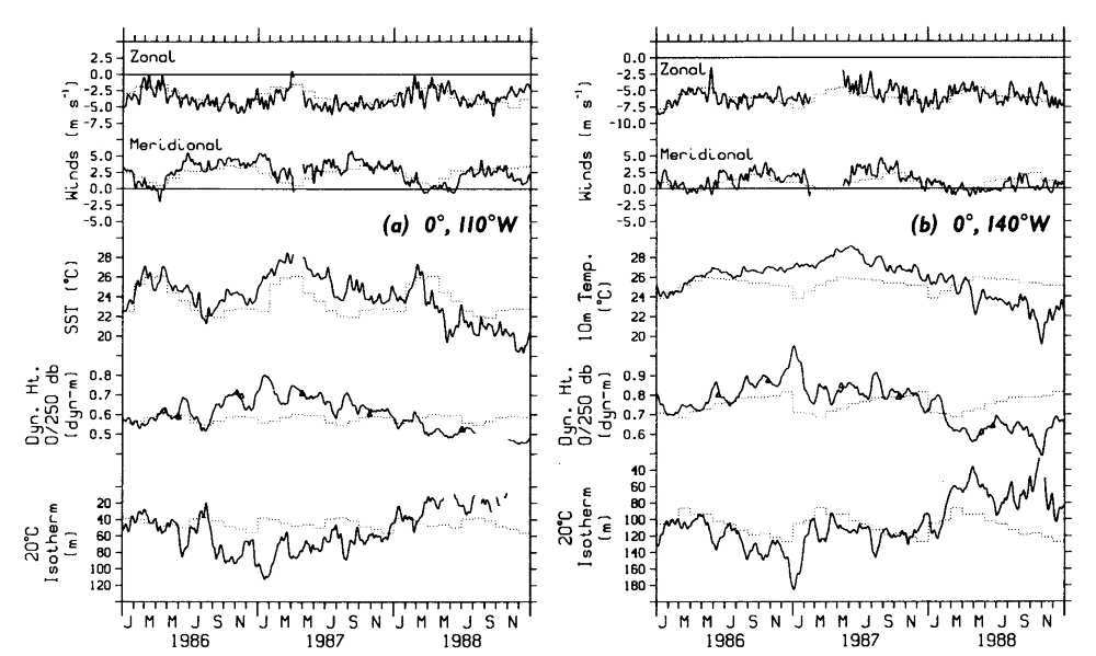
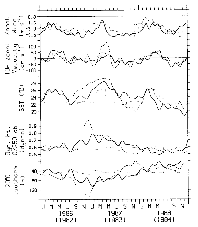
Figure 2. Zonal wind, meridional wind, sea surface temperature, dynamic height 0/250 dbar, and 20°C isotherm depth at (a)0°, 110°W and (b) 0°, 140°W. Temperature at 10 m has seen substituted for the more gappy sea surface temperature record at 140°W, since the two time series typically agree with one another to within about 0.1°C. Daily data have been smoothed with an 11-day Hanning filter. Superimposed on the time series are estimates of the monthly mean seasonal cycle based on mooring data. Dynamic heights of 0/250 dbar from CTD casts are also indicated (triangles).
Mean seasonal cycles have been estimated from monthly averaged mooring data
at 100°W and 140°W and plotted in Figures 2,
3, 4, 5,
8, and 10. Appendix
B describes the derivation and comparison of these climatologies with Reynolds'
[1988] SST climatology and Wyrtki
and Meyers' [1975] wind climatology. Uncertainties in the estimates
of climatological monthly means from the moorings are about 1°C (SST), 10 m
(20°C isotherm depth), 4 dyn. cm (dynamic height), 20 cm s
(zonal currents), and 1 m s (winds). Thus,
when discussing anomalies from the mean seasonal cycles in the following sections,
we will focus on those variations persisting longer than 1 month in excess of
the values quoted above.
Go back to Introduction or forward to next section