During the mid-1960s, Wyrtki assembled the physical picture that had been gained under the Scripps cruises and longterm ship-drift records into three partly overlapping papers (Wyrtki, 1965, 1966, 1967). These summary papers represented his own work, and also that of Cromwell (1958), Wooster and Cromwell (1958), Knauss (1960), Roden (1962), Bennett (1963) and other Scripps collaborators. The historical shipdrift data (Cromwell and Bennett, 1959) tracked the surface currents and their seasonal variations in fair detail, and a series of expeditions conducted by Scripps, by government fisheries vessels, and under the CalCOFI program (see Table 1 of Wyrtki, 1966) provided a few hundred bottle casts and a few thousand bathythermograph profiles in the region.
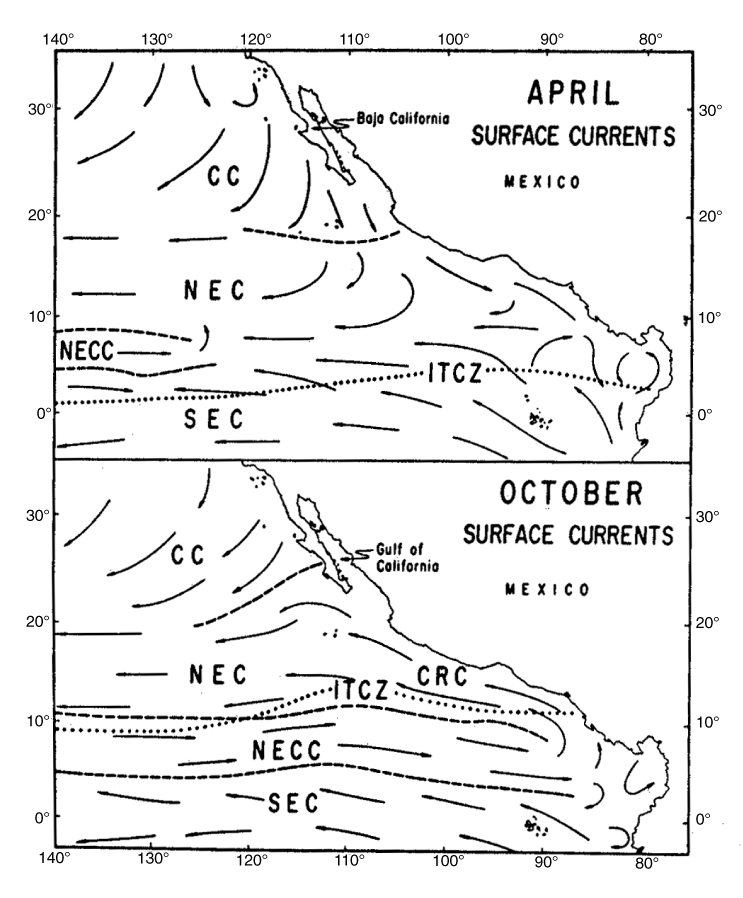
This by-modern-standards-limited dataset enabled Wyrtki to draw the schematic seasonal surface circulation shown in Fig. 3, which is in broadscale agreement with results from the picture that would be drawn from the much more comprehensive modern surface drifter data set (Fig. 4). Among the important features recognized were the winter extension of the California Current southward past Cabo San Lucas, the strengthening of the North Equatorial Countercurrent (NECC) during August–January, and its drastic weakening in the east during boreal spring (Section 4.2), the mean Costa Rica Dome and associated Costa Rica Coastal Current (CRCC) (Section 4.1), and the cyclonic circulation in the Panama Bight (Fig. 4). Roden (1962) had shown the relevance of wind-driven Sverdrup dynamics to the eastern Pacific, especially in realizing that the Peru Undercurrent must be rather strong (making the total transport southward along the Peru coast), though he was limited by the poor quality of wind datasets available. Important missing elements in the mid-1960s picture were the weakness of the South Equatorial Current (SEC) in a narrow band right at the equator (especially during March–July) (Section 4.3) and the connection between the NECC and the SEC (which is still poorly known). Although Peru upwelling was well known and equatorial upwelling was surmised (Cromwell, 1953), the three-dimensional structure of the eastern Pacific was not well understood. Wyrtki was aware of the sharp SST front bordering the north edge of the equatorial cold tongue (Cromwell, 1953), but the tropical instability waves (TIW) that distort the front on monthly timescales (Baturin and Niiler, 1997; Chelton et al., 2000) were not discovered until the advent of satellite SST in the late 1970s (Legeckis, 1977). Similarly, the strong eddies that occur under the winter winds blowing through the gaps in the Central American cordillera (Willett et al., 2006) were not described until the 1980s, although the effects of these winds on the shape of the local thermocline were described by Roden (1961). The Costa Rica Dome was an early focus because of the importance of the tuna catch there, and Wyrtki (1964) devoted an entire paper to it. However, the lack of appreciation at that time for the role of wind-driven vorticity dynamics led him to drastically underestimate the upwelling into the Dome and to misunderstand its mechanism (see Section 4.1).
Fig. 3. Annual cycle surface circulation based on ship-drift records (after Baumgartner and Christensen, 1985, which was adapted from Wyrtki, 1965). Current abbreviations are: California Current (CC), North Equatorial Current (NEC), North Equatorial Countercurrent (NECC), South Equatorial Current (SEC) and Costa Rica Coastal Current (CRC). The Intertropical Convergence Zone (ITCZ) is marked by a dotted line. Dashed lines around the NECC show its varying extent.
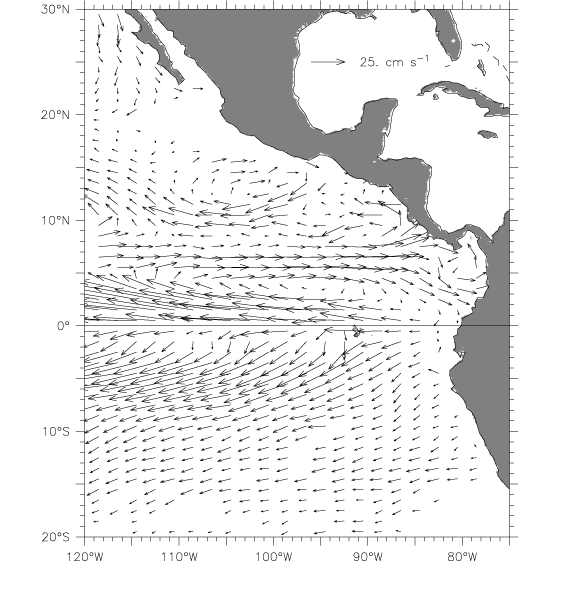
Fig. 4. Mean surface circulation from surface drifters. Vectors were left blank if either the total count of samples in that 1° × 1° box was less than 10, or if fewer than 4 months of the year were represented. The scale vector is located in the Gulf of Mexico.
A key factor that enabled a description of the circulation was the then-recent discovery of the equatorial undercurrent (EUC; Cromwell et al., 1954; also see McPhaden, 1986 and Montgomery, 1959 for historical overviews). By the time Wyrtki wrote his summary papers in the early 1960s, several expeditions had confirmed and added detail to Cromwell's discovery (Knauss, 1960), and it was obvious that the large eastward transport of the EUC must play a major role in the mass balance of the eastern Pacific. Previously, it had been hard to account for the westward growth of the SEC, which is much larger than the Humboldt Current that apparently fed it. Knauss (1960) estimated the EUC transport at 39 Sv, and Wyrtki (1966) drew a schematic circulation (reproduced here as Fig. 5a), in which about 20 Sv of EUC water went into the SEC near the Galapagos. However, though realizing that substantial EUC water must feed the SEC, Wyrtki (1966) thought that a large upwelling transport was impossible, commenting "the amount of water upwelled along the equator certainly does not exceed a few 10![]() cm
cm![]() /s [Sv], otherwise the thermal structure would break down". Therefore, he postulated that the EUC water must move into the lower levels of the SEC without rising to the surface. Wyrtki corrected himself 15 years later with a since-confirmed estimate of 50 Sv of upwelling over 170–100°W, based on the meridional divergence of Ekman and geostrophic transports (Wyrtki, 1981). A remaining item of confusion that was not cleared up until much later concerned the spreading of isotherms about the EUC (Fig. 6 and Section 4). It was thought at the time that this spreading must be a signature of vertical mixing, which seemed reasonable in such a strong current. However, turbulence measurements beginning with Gregg (1976) showed that mixing is in fact very weak at the EUC core; instead being strong in the stratified region above the current where it serves to maintain the balance between large upwelling transport and downward heat flux (see Gregg, 1998 for a review of the turbulence observations, and Fiedler and Talley, 2006 for a description of the EUC hydrography).
/s [Sv], otherwise the thermal structure would break down". Therefore, he postulated that the EUC water must move into the lower levels of the SEC without rising to the surface. Wyrtki corrected himself 15 years later with a since-confirmed estimate of 50 Sv of upwelling over 170–100°W, based on the meridional divergence of Ekman and geostrophic transports (Wyrtki, 1981). A remaining item of confusion that was not cleared up until much later concerned the spreading of isotherms about the EUC (Fig. 6 and Section 4). It was thought at the time that this spreading must be a signature of vertical mixing, which seemed reasonable in such a strong current. However, turbulence measurements beginning with Gregg (1976) showed that mixing is in fact very weak at the EUC core; instead being strong in the stratified region above the current where it serves to maintain the balance between large upwelling transport and downward heat flux (see Gregg, 1998 for a review of the turbulence observations, and Fiedler and Talley, 2006 for a description of the EUC hydrography).
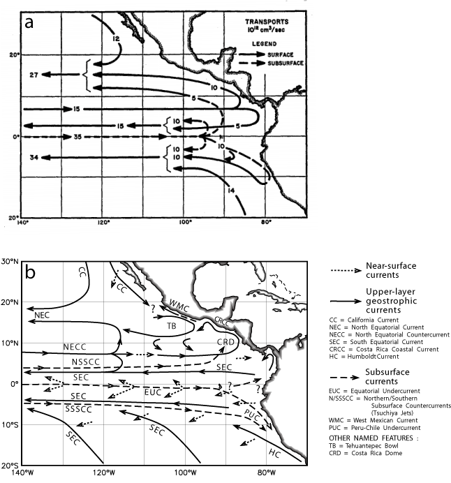
Fig. 5. Schematic three-dimensional circulation in the eastern tropical Pacific. (a) After Wyrtki (1966). (b) The circulation based on modern data. The legend at the right lists the names of currents and features referred to in the text. Several question marks indicate regions where the interconnections among the currents remain unknown (see text).
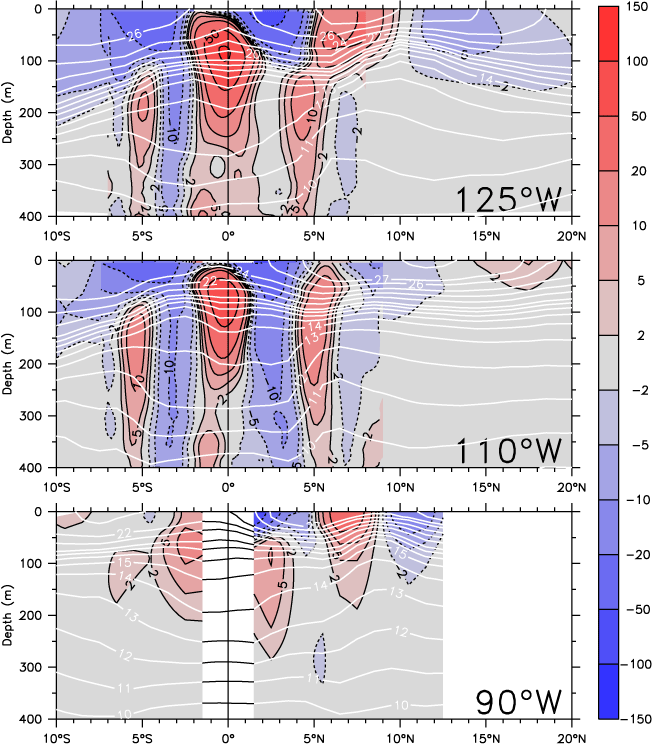
Fig. 6. Mean meridional sections of temperature (white contours) and zonal current (color shading, where red is eastward and blue westward; cm s![]() ) at the three longitudes listed in the lower right corner of each panel. At 125°W and 110°W, directly measured currents are shown within ±8° latitude (see Appendix C.1); elsewhere the currents are geostrophic.
) at the three longitudes listed in the lower right corner of each panel. At 125°W and 110°W, directly measured currents are shown within ±8° latitude (see Appendix C.1); elsewhere the currents are geostrophic.
Return to previous section or go to next section