Spurred by the valuable tuna fishery of the region, a major effort was undertaken in the late 1950s and early 1960s by the Scripps Institution of Oceanography, in collaboration with national and international fisheries research organizations, to observe the eastern tropical Pacific. Indeed, the opportunity presented by this program brought Klaus Wyrtki to Scripps in 1961 (Von Storch et al., 1999). The seminal papers describing the circulation, dynamics and water properties of the region came out of this project (Reid, 1948; Cromwell, 1958; Wooster and Cromwell, 1958; Cromwell and Bennett, 1959; Roden, 1961, 1962; Bennett, 1963; Wyrtki, 1964, 1965, 1966, 1967; Tsuchiya, 1975). Following this productive period, relatively few in situ physical observations have been made; for example more than 30% of the total modern database of hydrographic profiles in the region east of 130°W between 30°S and 30°N were taken before 1975. The literature shows a similar pattern. Until the recent interest in the eddies off Central America (see Willett et al., 2006), there was a significant fall-off in publications discussing the circulation of the region after the mid-1960s; except for an ongoing effort by researchers at CICESE (Baumgartner and Christensen, 1985; Badan-Dangon et al., 1989) and studies of equatorial dynamics based on the TAO (Tropical Atmosphere Ocean; see Hayes et al., 1991) moorings and cruises along 110°W (e.g., McPhaden and Hayes, 1990), only scattered papers were published on the low-frequency regional circulation between 1967 and 2002. Since the Wyrtki papers of the 1960s are still widely cited as the authoritative description of the regional circulation (e.g., Badan-Dangon, 1998), it seems useful to review what was known at that time and what has been learned since to confirm, supplement, update or contradict that description. The circulation reviewed here is related to the physical forcing and water mass characteristics described in reviews of the east Pacific atmosphere (Amador et al., 2006), the variability of the surface heat fluxes (Wang and Fiedler, 2006), the hydrography of the eastern Pacific (Fiedler and Talley, 2006), the regional signatures of interdecadal variations and climate change (Mestas-Nuñez and Miller, 2006), and the mesoscale eddies (Willett et al., 2006).
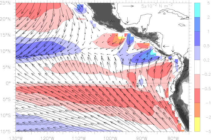
Much of the descriptive and dynamical study of the tropical Pacific from the 1970s to the 1990s focused on the long zonal scales of the central Pacific, where the winds, thermal structure and currents are nearly a function of latitude alone, and where a zonal-average meridional section is a useful approximation. By contrast, in the east the presence of the American continent is the dominant factor, producing strong meridional winds and zonal variations of forcing and properties. In addition, the necessity for the large zonal transports to be redistributed as the currents feel the coast produces a complicated three-dimensional structure. The focus of this review is on the circulation in the region where the shape of the continent and the continentally influenced winds are the dominant factor; for recent discussions of circulation in the central Pacific see McPhaden et al. (1998); Lagerloef et al. (1999); Johnson and McPhaden (1999); Johnson et al. (2002). The region affected by the continent extends as far as 2500 km west of the coast of Central America, though much less than this north of 20°N or south of the equator. A physically based way to define the region is where the southeast corner of the mean North Pacific Gyre does not reach into the large bight between central Mexico and Ecuador; this definition has the boundary stretching south from the tip of Baja California approximately along 110°W. This conforms to the eastern edge of the gyre-like winds of the North Pacific and of the zonally oriented Intertropical Convergence Zone (ITCZ) that is typical of the central Pacific (Fig. 1; see Section 4.1). The wind forcing associated with the ITCZ between the two subtropical highs produces the long ridges and troughs that bound the zonal currents of the central Pacific (South Equatorial Current (SEC), North Equatorial Countercurrent (NECC), and North Equatorial Current (NEC)). East of 110°W this ridge-trough system breaks down (Fig. 2, and see Fiedler and Talley, 2006), allowing meridional flows and strong zonal gradients of both winds and currents, with southerly cross-equatorial winds and a complex system of currents that exchange mass meridionally. The region between the tip of Baja California and the equatorial cold tongue also roughly coincides with the east Pacific warm pool (Wang and Fiedler, 2006), so it makes sense to discuss it as a distinct dynamical and climatic regime. To the south, equatorial dynamics tie the entire equatorial region firmly together, so the eastern equatorial Pacific's circulation cannot be considered in isolation. As Wyrtki (1966) noted, physical features like the cold tongue extend far out into the central Pacific and do not have a welldefined boundary on their west. In addition, Kelvin waves efficiently carry the signatures of west-central Pacific wind anomalies to the east, and determine a large fraction of east Pacific thermocline depth variations (e.g., Spillane et al., 1987; Kessler and McPhaden, 1995b). However, winds in the far eastern equatorial Pacific are distinct in being characterized by a strong southerly cross-equatorial component (Fig. 1), unlike the nearly zonal winds of the central basin, which suggests a qualitatively different dynamical regime in the east. In keeping with the definition used for the region north of the equator, we will define the eastern part of the equatorial Pacific as the longitude range where the meridional component of the wind is larger than the zonal component; this boundary is approximately at 110–105°W (Fig. 1). Much field study over the past two decades has been done in connection with the TAO mooring at 110°W, so this choice allows incorporation of that work in the review.
Fig. 1. Mean wind stress (vectors) and wind stress curl (colors) averaged over August 1999–July 2002. Blue shading shows positive curl (upwelling in the northern hemisphere) and red negative curl, in units of 10![]() Nm
Nm![]() , with (stretched) color key at right. The scale vector is in the Gulf of Mexico. Gray shading on land indicates altitudes greater than 250 m. The three mountain gaps referred to in the text are marked with arrows on the Atlantic side; from north to south these jets are denoted Tehuantepec, Papagayo, and Panama.
, with (stretched) color key at right. The scale vector is in the Gulf of Mexico. Gray shading on land indicates altitudes greater than 250 m. The three mountain gaps referred to in the text are marked with arrows on the Atlantic side; from north to south these jets are denoted Tehuantepec, Papagayo, and Panama.
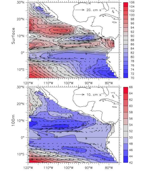
Fig. 2. Mean dynamic height and geostrophic currents relative to 400 m. Top: surface. Bottom: 100 m. Red colors indicate high dynamic heights, blue low (color scales on right). The contour interval is 2 dyn cm. The scale vector for each plot is located in the Gulf of Mexico. Geostrophic current vectors are omitted within ±3° latitude.
Return to Abstract or go to the next section