4.2. The annual cycle in the northeastern region
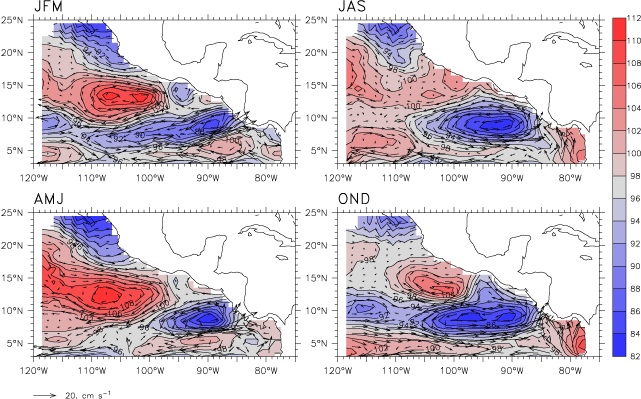
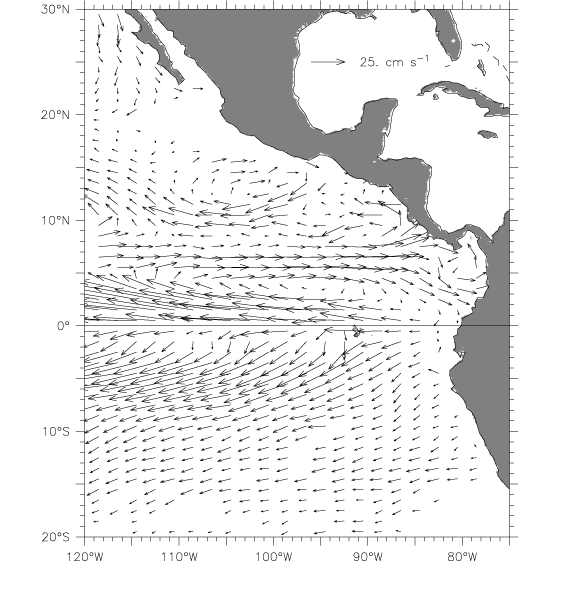
Although the mean situation in the eastern tropical Pacific is quite different from the central basin, annual cycle thermocline depth variations are similar in phase and amplitude to those much further west (Kessler, 1990). These anomalies consist of an out-of-phase relation across a line slanting from 8°N, 120°W to 3°N, 90°W, which is a continuation of a nodal line that extends along roughly 8°N to about 170°W (Kessler, 1990; and see Fig. 9b of Fiedler and Talley, 2006). These thermocline variations appear entirely consistent with that due to the wind stress curl, which also varies out of phase across 8°N from the Philippines east to 90°W, as the upwelling curl of the ITCZ moves north and south with the sun. In November, following several months in which the ITCZ is at its most northerly, the thermocline is shallow north of the line and deep south of it, and the reverse occurs in May. Since this nodal line runs roughly along the axis of the NECC, the result is to increase the thermocline slope across the NECC in November, and weaken it in May (Fig. 7). To a lesser degree, these anomalies also strengthen and weaken the NEC and SEC at the same time. During November, the NECC is strong across the basin; it flows eastward to the coast and around the Costa Rica Dome and then into the NEC (Fig. 7, lower right). Both these currents are entirely zonally oriented at this time, and appear as a continuous flow. During May, the situation is quite different. The geostrophic NECC is absent (flow in this latitude range is actually reversed) from 130°W to 100°W, and the NEC is fed instead by water coming south from the California Current and clockwise around a much-strengthened Tehuantepec Bowl, which has moved somewhat further offshore at this time of year (Fig. 7, lower left, and see the results of the Rossby wave model in Section 4.2.1). Much more southward geostrophic flow is observed in the first half of the year, weakening or reversing the surface WMC and apparently allowing water from the California Current to penetrate far into the tropics. These equatorward surface flow anomalies are also seen in altimetric sea level, extending as far north as California in boreal spring (Strub and James, 2002b). (However, subthermocline flow in the WMC appears to be less seasonally variable.) It is possible that boreal spring conditions open a window that allows water properties to communicate from the mid-latitude to the tropical eastern Pacific.
Fiedler (2002) used climatological temperatures and winds to diagnose the annual cycle of the Costa Rica Dome, and described a similar sequence as seen in Fig. 7. Fiedler's data showed that thermocline uplift begins at the coast in February–April as strong upwelling wind stress curl occurs on the south flank of the Papagayo wind jet. In May, the Papagayo winds weaken and the dome separates from the coast. During July–October, as the ITCZ moves north, upwelling curl lifts the 10°N thermocline ridge across the entire basin, including the eastern tropical Pacific, and the ridge strengthens and becomes more closely connected with the Costa Rica Dome, which appears to have lengthened to the west. During November–January, the ITCZ moves south, and northeast trade winds blow strongly over the region; the dome deepens to its weakest values by January. However, the core region of the dome, at 90°W, has relatively little annual thermocline depth variation compared to the other upwelling regions of the eastern Pacific (Fig. 9), with most of the changes seen in its westward expansion and contraction (Fig. 7), and the CRCC remains strong throughout the year. This lack of variability occurs because upwelling curl is provided not only by the Papagayo jet on the north side of the dome in winter but also by ITCZ westerlies on the south side of the dome in summer, and thus is relatively constant during the year. Further west, away from the Papagayo jet, curl variability is dominated by ITCZ migration and its annual cycle is much larger. The Tehuantepec wind jet occurs in boreal winter, which produces upwelling curl to the north of the dome; this upwelling shoals the northern edge of the dome while its center is deepening (note the northward bump on the dome in the lower right panel of Fig. 7).
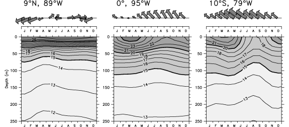
Fig. 9. Average annual cycle of wind stress vectors (top panels) and temperature (bottom panels) at the center of the Costa Rica Dome (9°N, 89°W; left), the equatorial cold tongue (0°W, 95°W; middle) and the Peru coastal upwelling (10°S, 79°W; right). Winds are the ERS scatterometer winds over 1991–2000, and both the length and thickness of the vectors increases with magnitude; the largest vector (June at the coast of Peru) has a magnitude of 5.8 N m![]() . Temperatures are from the AOML XBT data set.
. Temperatures are from the AOML XBT data set.
Fiedler's linear, wind-driven interpretation of the Costa Rica Dome annual cycle agrees with diagnoses made from much cruder data by Hofmann et al. (1981), but others have suggested that nonlinearities are also important. Umatani and Yamagata (1991) argued that cyclonic eddies produced near the coast by strong Papagayo winds "seed" the growing Costa Rica Dome and are an essential element of its formation. In the next section, we use a simple model consisting only of linear long Rossby waves to suggest that although the eastern tropical Pacific is rich with seasonal eddies, the low-frequency dynamics evolves principally according to a linear interpretation.
The Tehuantepec Bowl has a larger annual cycle amplitude than the Costa Rica Dome (Fig. 7), but has not been as well described in the literature. The bowl is nearly absent in boreal summer-fall, and grows as an isolated feature during boreal winter, with the 20 °C isotherm at least 10 m deeper than its surroundings. In spring, the thermocline trough at 15°N amplifies and appears to extend eastward as the bowl moves west, connecting the two. In the sequence of observed thermocline depth anomalies (left panels of Fig. 10), this can be seen as the deep thermocline centered at 13°N, 100°W in the JFM season that lengthens as a long trough to the west in April–May–June, then shoals (weakens) greatly in summer.
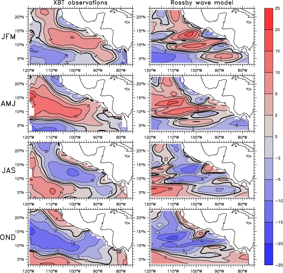
Fig. 10. Comparison of annual cycle anomalies of observed 20 °C depth (left panels) and the Rossby wave model solution (Section 4.2.1) (right panels), for four average seasons (indicated to the left of each row). The common color key is at right, with contour interval of 5 m. Positive values (red) indicate deep anomalies and negative values (blue) indicate shallow anomalies.
Winds and precipitation in the region between the equator and 10°N are strongly influenced by the large annual cycle of cold tongue SST, which is warmest in March and coolest in September (Mitchell and Wallace, 1992; Kessler et al., 1998). At minimum cold tongue SST, the temperature difference between the equator and the head of the Panama Bight is more than 6 °C, fostering the low-level southwesterly Choco jet (Poveda and Mesa, 2000; Amador et al., 2006), that feeds moisture to the west slopes of the Colombian Andes. The poleward coastal winds of the Choco jet are downwelling favorable, and Rodriguez-Rubio et al. (2003) use high-resolution satellite altimetry to argue that this produces a sea level high and anomalously anticyclonic circulation in the Bight during boreal summer-fall (though it remains unclear if the mean cyclonic gyre (Fig. 4) actually reverses or just weakens). Investigators are also beginning to explore the impact of SST variations driven by ocean dynamics on the precipitation fields on the region. Xie et al. (2005) showed that while the ITCZ stretches across the east Pacific warm pool in summer, persistently cooler SSTs above the Costa Rica Dome inhibit convection and produce a 500-km wide dry spot in the ITCZ at this time. Similarly, in winter the ITCZ moves south, drawing the Panama jet across the Isthmus and over the Pacific. Upwelling curl associated with the left (southeast) flank of this jet generates a cyclonic eddy in the Panama Bight and SST cooling in its center (Rodriguez-Rubio et al., 2003). As was seen to be the case when the ITCZ straddled the Costa Rica Dome in summer, a dry spot interrupts the convective precipitation over the Bight. The Tehuantepec jet does not have a corresponding effect because the large-scale precipitation in that region occurs in summer when the jet is inactive.
Return to previous section or go to next section