To complement the maps on neutral surfaces, two sets of meridional-vertical sections are compared and contrasted, one along 165°E, representative of the western Pacific, and another along 125°W, representative of the eastern Pacific. These sections are similar in areal extent to a set of mean sections used to discuss currents and water masses in the central Pacific (Wyrtki and Kilonsky 1984). Sections of salinity and planetary potential vorticity are displayed with neutral surfaces (referred to as isopycnals) overlaid and are discussed as tracers of the net meridional circulation and the deep cyclonic gyres.
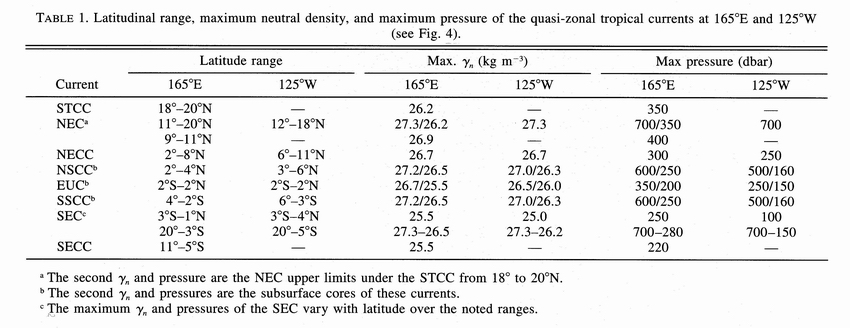
The latitude ranges, maximum densities and pressures, and core densities and pressures of the quasi-zonal tropical currents (Table 1) generally shoal with the pycnocline, tilted upward to the east by the trade winds and shift poleward from west to east. The eastward-flowing Subtropical Countercurrent (STCC), associated with northward isopycnal spreading in the STMW, and is only present at 165°E where the STMW is strong. The NEC at 125°W is poleward of its location at 165°E where its northern end flows beneath the STCC. The NECC at 125°W is also poleward and shallower than it is at 165°E. The maximum extents and cores of the SCCs are poleward, shallower, and lighter at 125°W than at 165°E. Unlike at 165°E, these currents are easily distinguished from the EUC and the NECC at 125°W. The EUC is shallower and lighter at 125°W than at 165°E. The north branch of the SEC at 125°W is shallower, lighter and extends farther north than at 165°E. The south branch of the SEC at 125°W is shallower, lighter, and stronger than at 165°E. The SECC is only evident at 165°E. These zonal shifts imply geostrophic equatorward convergence within the pycnocline and divergence below it.
Table 1. Latitudinal range, maximum neutral density, and maximum pressure of the quasi-zonal tropical currents at 165°E and 125°W (see Fig. 4).
At 165°E (Fig. 4a), the NPTW salinity maximum
at  n = 24.0 kg m
 near 20°N is reduced, partly owing to zonal flow, under the ITCZ around
8°N between the fresh surface waters and the NPIW. Here the NPIW salinity
minimum near n = 26.8 kg
m at 20°N dominates the fresh northern
water approaching the equator along serpentine routes, lightening to n
= 26.1 kg m by 1°N. This density
shift of the salinity minimum is realized because only the lightest portion
of the NPIW influence flows toward the equator in the interior and that from
the western boundary flows east in the NSCC. In the south, fresh AAIW is noticeable
at depth. The SPTW salinity maximum contrasts strongly with the fresh northern
water as both converge on the EUC. The interruption of the 35.8 isohaline at
10°S is associated with fresh eastward flow in the SECC. Around n
= 26.8 kg m a southern salty influence
can be seen within the entire deep equatorial pycnostad between 3°S and
3°N. The local meridional minimum at 5°N, the northern edge of the
NSCC, is advected eastward, as are slightly salty waters at 5°S in the
southern edge of the SSCC. Around this same density, a homogenous local vertical
maximum between 5°N to 11°N and 250 to 450 m is the result of mixing
at the center of the deep cyclonic gyre. This gyre separates the fresh waters
to the north from the saltier equatorial waters.
near 20°N is reduced, partly owing to zonal flow, under the ITCZ around
8°N between the fresh surface waters and the NPIW. Here the NPIW salinity
minimum near n = 26.8 kg
m at 20°N dominates the fresh northern
water approaching the equator along serpentine routes, lightening to n
= 26.1 kg m by 1°N. This density
shift of the salinity minimum is realized because only the lightest portion
of the NPIW influence flows toward the equator in the interior and that from
the western boundary flows east in the NSCC. In the south, fresh AAIW is noticeable
at depth. The SPTW salinity maximum contrasts strongly with the fresh northern
water as both converge on the EUC. The interruption of the 35.8 isohaline at
10°S is associated with fresh eastward flow in the SECC. Around n
= 26.8 kg m a southern salty influence
can be seen within the entire deep equatorial pycnostad between 3°S and
3°N. The local meridional minimum at 5°N, the northern edge of the
NSCC, is advected eastward, as are slightly salty waters at 5°S in the
southern edge of the SSCC. Around this same density, a homogenous local vertical
maximum between 5°N to 11°N and 250 to 450 m is the result of mixing
at the center of the deep cyclonic gyre. This gyre separates the fresh waters
to the north from the saltier equatorial waters.
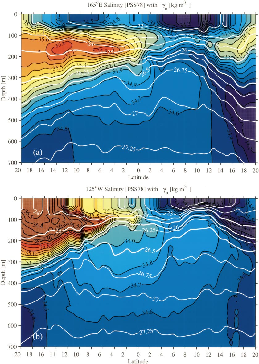
Figure 4. Mean meridional-vertical sections of salinity contoured at 0.1
intervals (PSS-78) with contours of n
at varying intervals (thick lines 25.0, 26.0, and 26.5 kg m)
overlaid in white. Color palettes follow Fig. 2. Nominal vertical exaggeration
is 5000:1. (a) 165°E. (b) 125°W.
At 125°W (Fig. 4b) the salinity minimum
is shallower and lighter than at 165°E; CCW influence at n
= 25.5 kg m near 20°N persists as
a subtle vertical minimum to 1°N at n
= 25.0 kg m, roughly following neutral
surfaces on its serpentine equatorward path. Where the pycnocline is shallowest,
around 12°N, the fresh surface influence of precipitation under the ITCZ
may augment that of the CCW. The northern deep salinity minimum is much weaker
and denser than at 165°E, reflecting an absence of NPIW influence here.
The AAIW salinity minimum around n
= 27.2 kg m at 20°S is stronger than
at 165°E, being closer to the southeast Pacific where AAIW is freshest.
Above the AAIW is the strong SPTW salinity maximum at n
= 24.5 kg m. This maximum is formed by
excess evaporation over precipitation where the neutral surface outcrops in
the southeast Pacific, which is why it is stronger here that at 165°E.
An isolated vertical maximum at 1°S, n
= 25.0 kg m (not visible in Fig.
4b, but see Fig. 2c) is SPTW advected eastward
in the EUC, where convergence creates a strong contrast with fresher northern
water. Around n = 26.5
kg m, salty southern influence is present
within the entire deep equatorial pycnostad, now between 5°S and 5°N.
Again local meridional extrema are advected eastward at the poleward edges of
the SCCs, now 6° from the equator. Around this same density, a homogenous
local vertical maximum between 7°N and 13°N is the result of mixing
within the center of the northern deep cyclonic gyre. All these deep equatorial
influences are poleward of and shallower than their locations at 165°E,
consistent with potential vorticity conservation below eastward pycnocline shoaling.
In addition, these influences are about 0.3 kg m
lighter at 125°W than at 165°E, suggestive of diapycnal mixing.
At 165°E, the pycnocline is strongest at n
= 23.5 kg m, and potential vorticity there
(Fig. 5a) is of roughly equal magnitude in both
hemispheres. STMW is evident at 20°N as a weak minimum at n
= 25.5 kg m, around the base of the STCC.
In the south, there is no corresponding vertical minimum, as 165°E is far
from the Southern Hemisphere eastern STMW source. Around n
= 26.7 kg m, the equatorial pycnostad
is manifest as a subtle local vertical minimum from about 3°S to 3°N
(not visible in Fig. 5a). Slightly denser, around
n = 27.0 kg m,
vertical minima expand poleward to 5°S (barely visible) and 11°N,
marking the equatorial influence in the deep cyclonic gyres poleward of the
SCCs. As in the property maps (Fig. 3), the
southern deep cyclonic gyre is more subtle than the northern deep cyclonic gyre.
Within these deep gyres below the pycnocline, the orthogonality of nearly vertical
isovorts and nearly horizontal isopycnals suggest an absence of significant
adiabatic meridional flows.
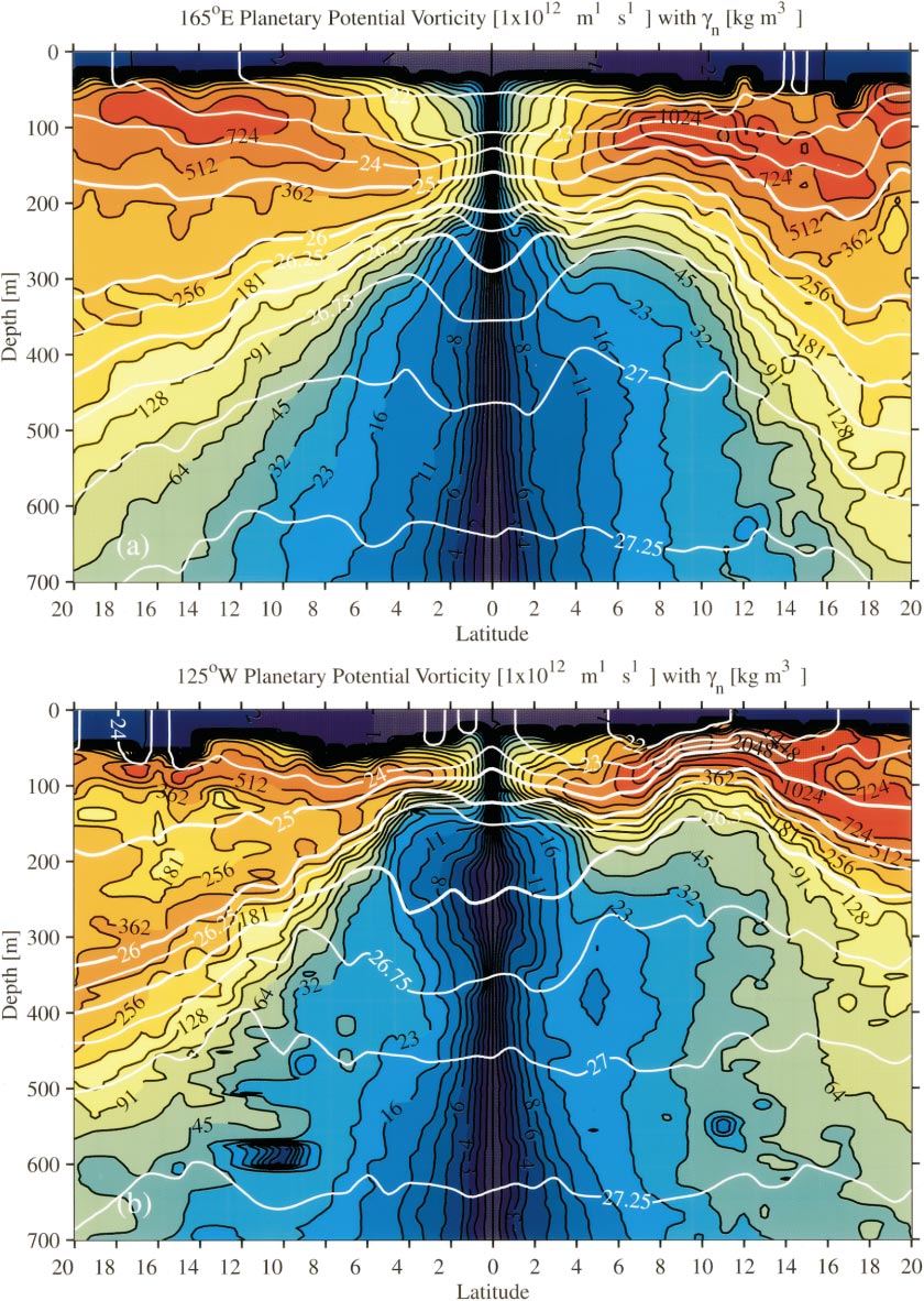
Figure 5. Mean meridional-vertical sections of planetary potential vorticity
contoured at logarithmic intervals (10 m
m s)
with contours of n at varying
intervals (thick lines 25.0, 26.0, and 26.5 kg m)
overlaid in white. Color palettes follow Fig. 2. Nominal vertical exaggeration
is 5000:1. (a) 165°E. (b) 125°W.
s)
with contours of n at varying
intervals (thick lines 25.0, 26.0, and 26.5 kg m)
overlaid in white. Color palettes follow Fig. 2. Nominal vertical exaggeration
is 5000:1. (a) 165°E. (b) 125°W.
At 125°W, potential vorticity (Fig. 5b)
is highest in magnitude within the pycnocline, around n
= 24.0 kg m, slightly denser but shallower
than at 165°E, probably because the mixed layer is lighter and deeper in
the west. Potential vorticity is high under the ITCZ from 9°N to 13°N,
where the pycnocline is closest to the surface. This maximum, much higher than
at 165°E, precludes direct meridional flow. As shown above (Fig.
3), water within the pycnocline must circumnavigate the high potential vorticity
under the ITCZ on its way from the subtropics to the equator. At 20°N,
the local vertical minimum at n
= 24.5 kg m is a signature of eastern
STMW that underlies the NPTW salinity maximum. In the Southern Hemisphere eastern
STMW is much more clearly evident as a broad vertical minimum between n
= 25.0 kg m and n
= 26.0 kg m. The meridional homogeneity
in Southern Hemisphere eastern STMW is the result of stratification increasing
linearly towards the equator to compensate the shrinking Coriolis parameter
and conserve potential vorticity. Hence in contrast to the northern pycnocline,
there is no impediment to direct meridional flow toward the equator within the
southern pycnocline. Around n
= 26.5 kg m, the deep equatorial pycnostad
is evident in the local vertical minimum from 5°S to 5°N. Slightly
denser, around n = 26.8
kg m, vertical minima expand poleward
to 10°S (barely visible) and 13°N, marking the equatorial influence
in the deep cyclonic gyres poleward of the SCCs. As in the salinity field, these
deep equatorial influences are all poleward of, lighter than, and shallower
than analogous features at 165°E. The poleward spread of low potential
vorticity below the pycnocline from west to east suggests deep interior meridional
flow is poleward in the presence of eastward zonal flow.
In summary, these two sections show the shoaling and strengthening of the pycnocline from west to east. Poleward shifts of the NEC and NECC from west to east are apparent, as are shoalings and poleward shifts of the SCCs. The salinity sections show the contrast at the equator between the strong salty SPTW in the southeast and the combined fresh northern influence of CCW in the northeast, surface water under the ITCZ, and NPIW in the northwest. Lateral extrema within the SCCs and the eastern EUC are suggestive of eastward zonal advection. The deeper homogeneity in salinity between the deep SEC and the SSCC, as well as between the deep NEC and the NSCC, suggests mixing within deep cyclonic gyres bounded by these currents. These gyres are associated with a lack of interior meridional convergence toward the equator across the Pacific in both hemispheres. The potential vorticity sections highlight the contrast between the Southern and Northern Hemisphere pycnoclines, with the ridge of high potential vorticity under the ITCZ presenting an obstacle to direct meridional flow in the northeast, but smaller barriers in the west and no such impediment in the southeast. STMWs are evident as vertical minima in potential vorticity under salinity maxima in the northwest and especially in the southeast. In addition, the low potential vorticity and high salinity within the deep cyclonic gyres in each hemisphere is consistent with a lack of equatorward convergence below the pycnocline. In fact, poleward spreading of these equatorial influences to the east between the SSCC and the deep SEC and between the deep NEC and the NSCC supports arguments for a deep poleward interior flow.
Return to previous section or go to next section