U.S. Dept. of Commerce / NOAA / OAR / PMEL
/ Publications
The Pacific Subsurface Countercurrents and an Inertial Model
Gregory C. Johnson and Dennis W. Moore
National Oceanic and Atmospheric Administration/Pacific Marine Environmental
Laboratory, Seattle, Washington
Journal of Physical Oceanography, 27, 2448-2459
Not subject to U.S. copyright. Published in 1997 by the American Meterological Society.
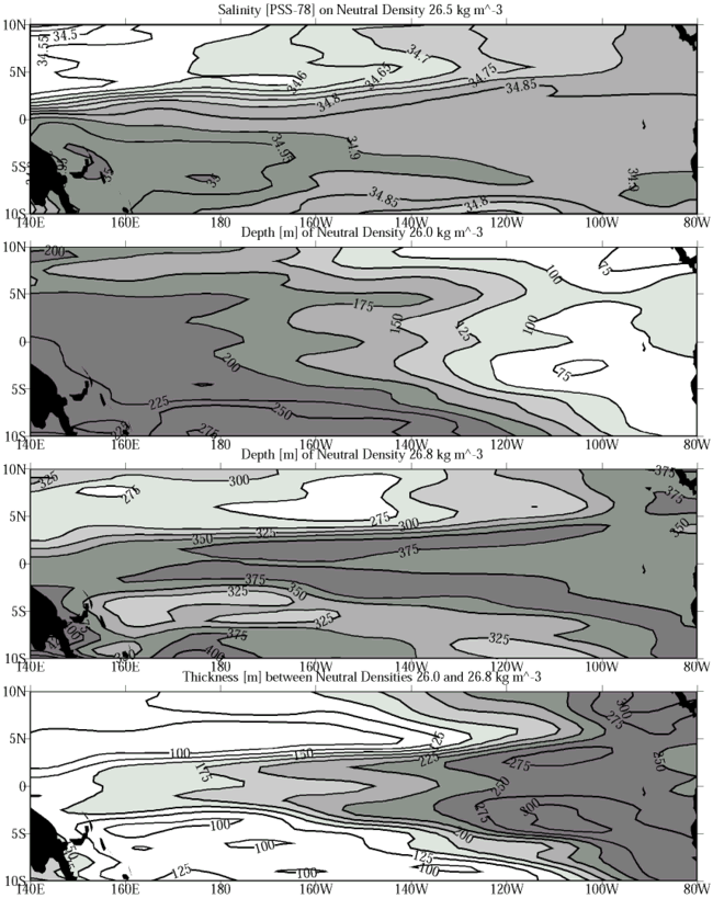
2. Data and data reduction
For this study, CTD stations within different areal bins in the tropical Pacific
are averaged to make a mean hydrographic profile for each bin (Fig.
3: the dots indicate the locations of mean hydrographic profiles near the
bin centers). In latitude, the bins are centered on every 1° from 20°S to 20°N.
Bin widths are 1° in latitude, and hence include CTD stations halfway between
integer latitudes. In longitude, the bins are centered on the TAO array mooring
longitudes (McPhaden
1993), with 85°W and 126°E added as central longitudes for the far eastern
and western Pacific. Bin widths ranging from 9° to 15° of longitude result from
bin edges located midway between these nominal longitudes. This strategy yields
13 mean meridional hydrographic sections, some better sampled than others, which
are used to make maps of properties on and between neutral density anomaly,
The CTD station data within each bin, consisting of salinity, S, and
temperature, T, as a function of pressure, P, are averaged
as a function of  n, surfaces,
and meridional property sections at 165°E, 155°W, and 110°W, the three best-sampled
longitudes. CTD stations include all high-resolution data available from the
NODC archives, as well as those in the PMEL database from PMEL and some other
cruises not yet available from NODC. Nearly 14,000 individual CTD stations are
used, located between 20.5°S and 20.5°N latitude and between 120°E and 80°W
longitude, taken from 1967 through 1996.
n, surfaces,
and meridional property sections at 165°E, 155°W, and 110°W, the three best-sampled
longitudes. CTD stations include all high-resolution data available from the
NODC archives, as well as those in the PMEL database from PMEL and some other
cruises not yet available from NODC. Nearly 14,000 individual CTD stations are
used, located between 20.5°S and 20.5°N latitude and between 120°E and 80°W
longitude, taken from 1967 through 1996.
The CTD station data within each bin, consisting of salinity S and
temperature T as a function of pressure P are averaged as
a function of n to create
mean hydrographic profiles. Averaging S, T, and P
as functions of n is more
involved than the conventional approach of averaging S, T,
and n as functions of P,
but the technique better preserves water properties in the sharp tropical pycnocline
(Gouriou
and Toole 1993). First, to reduce small-scale noise, individual CTD station
S and T profiles are filtered in P with a 10-dbar
half-width Hanning filter and subsampled at 10-dbar intervals. Then n
is computed for these subsampled data and averaged as a function of P
to obtain a mean n(P)
profile at 10-dbar resolution. Following this step, the individually filtered
and sampled profiles of S, T, and P are linearly
interpolated to each n(P)
profile value to allow averaging of the individual CTD station data as a function
of n at roughly 10-dbar
resolution. Mean profiles for S(n),
T(n), and P(n)
are then calculated. Finally the mean P(n)
profile is used to put the mean profiles of S(n)
and T(n) onto
an even 10-dbar grid and construct a final mean n
profile.
Depth and properties of the surface mixed layer, including n,
vary over time. To construct a mixed layer for the mean profiles of S(n),
T(n), and n,
the following procedure is used. First, the mixed-layer P for each
CTD station is defined as the P above which n
is less than 0.1 kg m-3 denser than the mean n
of the top 10 dbar. Mean S and T from the surface to the mixed-layer
P are calculated for each CTD station. Then these S and T
values are averaged, weighted by the individual mixed-layer P's so
that deeper mixed-layer values get more weight, to find mean mixed-layer values
for S and T. These values are used with the mean mixed-layer
P to calculate a mean mixed-layer n.
In order to avoid n inversions
in the mean profiles, the pressure of the mean mixed-layer n
in the final mean n profile
is used to define a final mean mixed-layer P. To finish, the mean mixed-layer
S, T, and n
values are substituted into the mean S(n),
T(n), and n
profiles from the mean mixed-layer P to the surface.
The resulting 10-dbar mean hydrographic profiles are used exclusively in the
analysis. The only further smoothing performed for the mean meridional sections
presented is on the square of the buoyancy frequency, N2,
which is calculated from the mean hydrographic profiles and then smoothed with
a 30-dbar half-width Hanning filter before use. Isopycnal maps are made by linearly
interpolating the 10-dbar values of each mean hydrographic profile to the appropriate
n. These values are then
objectively mapped assuming a Gaussian covariance with correlation length scales
of 1.5° lat and 18° long and an error energy of 0.04. These correlation length
scales are roughly 1.5 times the data separation, with anisotropy appropriate
for the interior of the Tropics, where zonal scales greatly exceed meridional
scales.
Return to previous section or go to next section
PMEL Outstanding Papers
PMEL Publications Search
PMEL Homepage