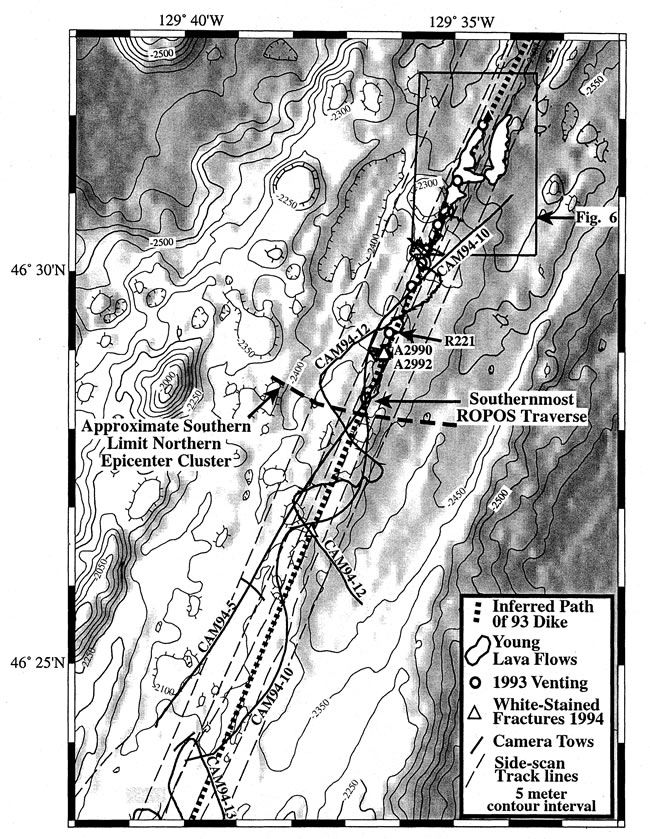
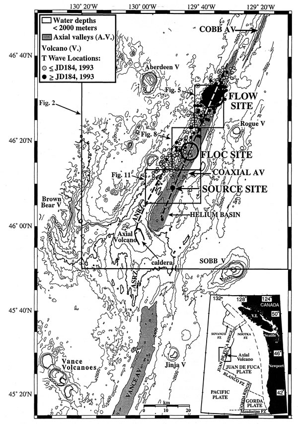
The dives made at the 1993 eruption site ("Flow site") with the ROPOS and the submersible Alvin mapped out the extent of the fresh lava flow and diffuse hydrothermal venting associated with a zone of fissures and narrow grabens extending several kilometers to its north and south [Chadwick et al., 1995; Embley et al., 1995] (Figures 5, 6, and 7). The eruption took place along an older volcanic ridge that extends north of Cage Volcano, a prominent 1-km diameter volcanic cone (Figure 6).
Figure 5. Bathymetric map of northernmost portion of CoAxial segment, including the Flow site. Bathymetry is side-lit from west with 50-m contours superimposed. Darker shades are deeper. Box shows area of Figure 6. Location on regional bathymetry shown in Figure 1.
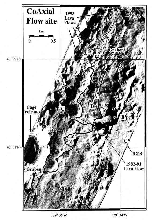
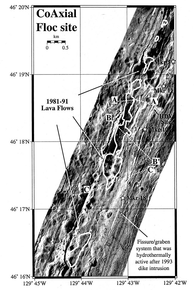
Figure 6. AMS-60 side-scan mosaic (two swaths) of 1993 and 1982–1991 lava flows at the Flow site, CoAxial segment. White lines are boundaries of young lavas determined by SeaBeam differencing anomalies and ROPOS and Alvin dives [Chadwick et al., 1995]. Dotted lines denote depth cross-section locations shown in Figure 7. Location shown in Figure 5.
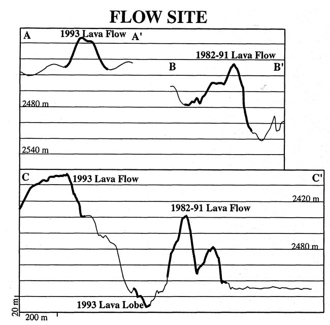
Figure 7. Depth cross-sections along submersible traverses of young lava flows at the Flow site, CoAxial segment. Young lavas are highlighted by thicker lines. Locations shown in Figure 6.
Differencing of SeaBeam bathymetric grids from surveys made in 1982, 1991,
and 1993 shows a well-defined positive depth anomaly coinciding with the glassy,
unsedimented lava observed (Figure 6 and Plates
2a and 2b) [Chadwick
et al., 1995]. One of the thicker (~30 m) portions of the lava flow
centered at 46°32.4 N (Figure
6) coincides with an area of intense hydrothermal activity observed during
ROPOS and Alvin dives in 1993 (Figure
6 and Plate 2c). Seafloor observations
made during ROPOS dives (e.g., R219, Figure
6) in August 1993 (probably less than 2 weeks after the eruption) showed
that the crestal region of the lava flow was emitting an extensive flow of warm
water up to 50°C from an area of drained-out flattened pillow lavas.
Fe-Si precipitates coated large areas of the crestal area where active venting
was taking place (Plate 2c) [Embley
et al., 1995; Juniper
et al., 1995].
N (Figure
6) coincides with an area of intense hydrothermal activity observed during
ROPOS and Alvin dives in 1993 (Figure
6 and Plate 2c). Seafloor observations
made during ROPOS dives (e.g., R219, Figure
6) in August 1993 (probably less than 2 weeks after the eruption) showed
that the crestal region of the lava flow was emitting an extensive flow of warm
water up to 50°C from an area of drained-out flattened pillow lavas.
Fe-Si precipitates coated large areas of the crestal area where active venting
was taking place (Plate 2c) [Embley
et al., 1995; Juniper
et al., 1995].
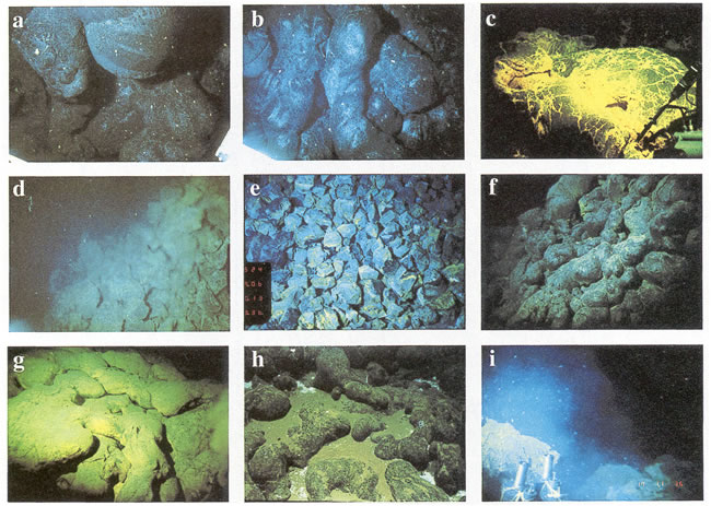
Plate 2. A series of 35-mm photographs from ROPOS (R) and Alvin (A) of lava flows and vents on CoAxial segment. Origin and year of photograph are given by, e.g., R93: (a) Lobes of pillow lavas on east flank of 1993 flow. Darker bands on pillow (~0.75 m diameter) in upper middle right are very delicate veneer of glass which sloughed off on contact. White particles are fallout in water column (Figure 6, ROPOS Dive 219, R93). (b) Sediment-free glassy tubes and pillows on east flank of 1993 eruption mound (R93). Pillow tube in center is ~0.5 m across (Figure 6, ROPOS Dive 219, R93). (c) Crest of 1993 lava flow showing extensive coating of Fe-Si deposit probably precipitated by Fe-oxidizing bacteria. Temperature probe (~1 m long) at lower right measured exit vent fluid temperatures as high as 51°C in the vicinity of this site (R93). (d) Extensive venting along fissure south of 1993 eruption (R93). (e) Brecciated zone along path of venting south of 1993 eruption site (Figure 7, Alvin Dive 2990, A95). Pieces are ~0.25 m across. (f) Flank of 1982–91 lava site lying 500 m east of the 1993 flow (A93). (g) Crest of the 1982–1991 lava flow; note duller color than Plate 2c (A93). (h) "Floc" drifts amidst older pillow lavas (note thick sediment pockets) along center of axial valley at about 46°19.4N (R93). (i) Turbid vent fluid rising out of fissure near Huge Diffuse Vent (HDV) at Floc site (Figure 9) (A93). Fissure is ~1 m wide.
High-resolution near-bottom bathymetric surveys using an AMS-60 deep-towed side-scan sonar and a Mesotech scanning sonar mounted on Alvin mapped well-defined narrow (~20 m wide) grabens at both the southern and northern ends of the 1993 lava flow (Figure 6). Chadwick and Embley [1998] propose that these structures formed above the 1993 dike that fed the eruption. In this paper we use the terms "fissure" and "graben" as by Chadwick and Embley [1998]. A fissure is a fracture whose walls have moved apart by pure extension. A graben is a linear topographic depression created by subsidence along inward facing normal faults. Small grabens are distinguished from fissures in that they have a well-defined downdropped center block.
Surveys and seafloor observations using the ROPOS and Alvin mapped
at least three small patches of lava north of the main lava flow (the northernmost
is at 46°32.5N) that erupted out of
narrow grabens. Low-level diffuse venting was observed within the northern graben
in August 1993, but none was observed in July 1994. An Alvin dive within
the graben at the southern end of the main lava flow (Figure
6) in October 1993 found extensive diffuse hydrothermal venting and bacterial
mats along its eastern wall, but venting had ceased by September 1995. Extensive
venting was also found southwest of the 1993 flow on the plateau south of Cage
Volcano in August 1993 at sites extending for 5 km SSW (~N202°E)
of the main lava flow (Figure 5 and Plate
2d). All six ROPOS transects, including the southernmost one at 46°28.4N,
crossed a narrow zone of venting associated with small grabens and or fissures
that cut through pre-1993 lavas (Figure 5). No
recently erupted lava was observed on any transect south of the main lava flow.
Camera tows in 1994 and Alvin dives in 1995 (Figure
5) did not detect any active hydrothermal venting south of the lava flow
where ROPOS observed it in 1993, but Alvin transects at two sites
revealed "fresh" appearing fissures and small grabens characterized by bright
white and yellow staining on the broken rock faces (Figure
5). At 46°29N, Alvin (dives
2990 and 2992) encountered a very unusual fractured zone characterized by brecciated,
pervasively stained basalt lying within a shallow graben up to 10 m wide (Plate
2e). Careful observation from Alvin's viewports confirmed that this
rubble was generated in situ, not tectonic talus generated from a nearby scarp.
The zone appeared to be continuous for at least 500 m along strike and located
along the line of (apparent) continuous venting observed by ROPOS in
1993.
In summary, the 1993 CoAxial eruption site consists of a 3.8-km-long, (up to) 500-m-wide lava flow, a zone of grabens and fissures extending at least 1 km northward which fed several small eruptions, and a zone extending at least ~4.5 km to the south characterized by grabens, fractured seafloor, and extensive diffuse venting (in 1993), but no fresh lavas. This entire active zone is at least 8.4 km in length. A plot of the T wave epicenters (Figure 1) shows that the events in the second half of the swarm(s) (after JD184) form a "bulls-eye" pattern at the eruption site that has the same diameter (~ 8 km) as the length of known along-axis venting and eruption (southern limit shown on Figure 5). The character and geometry of these structures as well as the short duration of hydrothermal venting along them are all consistent with the interpretation that they formed directly above the 1993 dike and thus reveal the path that the dike took along this section of the CoAxial segment. There is no evidence for any other 1993 eruption sites, but repeat SeaBeam surveys and camera tows have identified two pre-1993 eruption sites along the CoAxial segment, which are described in sections 6 and 8.
Return to previous section or go to next section
Return to Outstanding Publications Page
Return to PMEL Publications Page
Return to PMEL Home Page