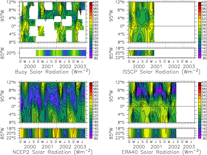
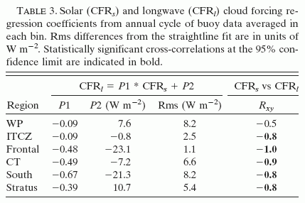
a. Surface downwelling radiation time series
Despite the fact that the sun is directly overhead twice per year, incident solar (Fig. 2) and longwave (Fig. 3) radiation both show strong annual cycles due to the presence of clouds. While the NWP radiation fields also show a strong annual cycle, the magnitude and latitudinal structure differ from the satellite and buoy benchmark datasets. In particular, both NWP-based analyses have too little incident solar radiation on and north of the equator and too much solar radiation and too little longwave radiation incident in the stratus deck region at 20°S, 85°W. In the following subsections, we will analyze these discrepancies in terms of cloud effects and background clear-sky radiative effects.
FIG. 2. Monthly averaged solar radiation incident on the surface along 95°W from 8°S to 12°N and at 20°S, 85°W from (top left) buoy measurements, (top right) ISCCP, (bottom left) NCEP2 reanalysis, and (bottom right) ERA-40. Solar radiation has units of W m![]() .
.
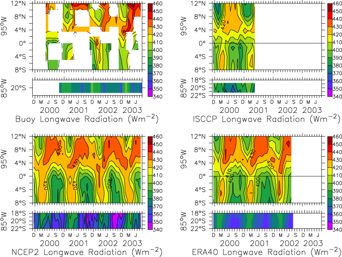
FIG. 3. Same as in Fig. 2 but for monthly averaged longwave radiation incident on the surface.
b. Surface cloud forcing time series
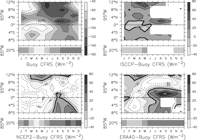
Solar cloud forcing (Fig. 4) and longwave cloud forcing (Fig. 5) evaluated from the four sources (buoy, ISCCP, NCEP2, and ERA-40) show qualitatively similar features. As expected, deep convection associated with the ITCZ results in large solar cloud forcing (reduction in downwelling solar radiation) with a strong seasonal cycle. In particular, the shadowing effect of the deep convection has a seasonal migration similar to the ITCZ (Mitchell and Wallace 1992), with a blanket of large solar cloud forcing over nearly all Northern Hemisphere sites during June–October and then maximum solar cloud forcing migrating equatorward during October–January. All fields show large solar cloud forcing between 4°S and 8°S in March, consistent with formation of a short-lived Southern Hemisphere ITCZ.
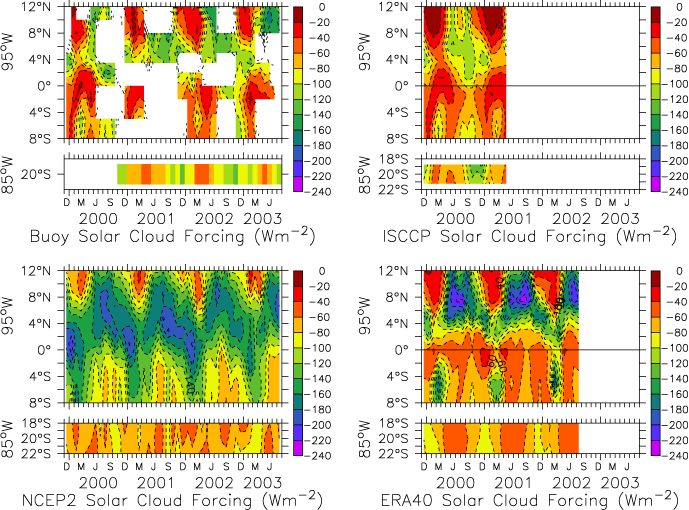
FIG. 4. Same as in Fig. 2 but for monthly averaged solar cloud forcing at the surface along 95°W from 8°S to 12°N and at 20°S, 85°W. Solar cloud forcing is defined by (1) and has units of W m![]() .
.
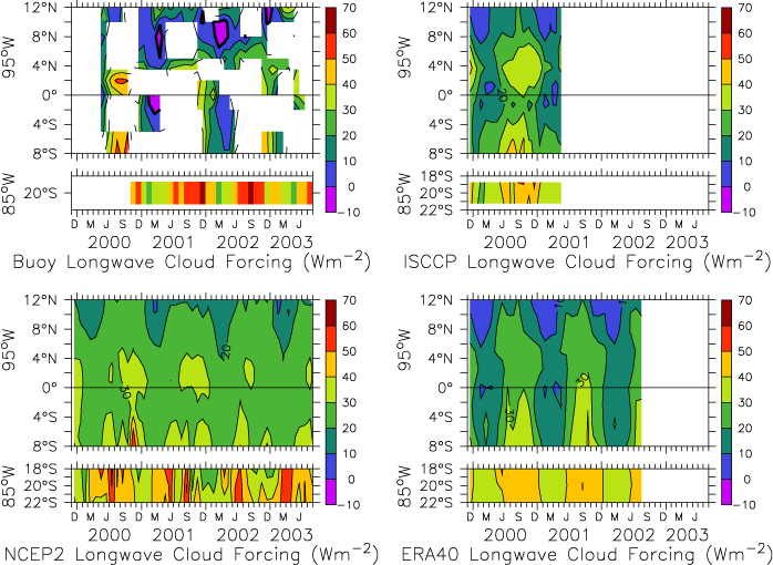
FIG. 5. Same as in Fig. 4 but for longwave cloud forcing. Longwave cloud forcing is defined by (1) and has units of W m![]() .
.
The greatest solar cloud forcing extends from about 10°N to 2°N (from the deep convection of the ITCZ to the SST front). In contrast, the greatest longwave cloud forcing is found in the Southern Hemisphere, with maximum values found at 20°S during the latter half of the year when a stratus cloud deck often extends to the equator (Klein and Hartmann 1993). Periods of relatively clear skies (e.g., January–March north of 5°N, and near the equator) are seen in both solar and longwave cloud forcing (as near zero). Weakly negative longwave cloud forcing values are nonphysical and represent errors in the buoy estimates.
While the four sets (buoy, ISCCP, NCEP2, and ERA-40) have many similarities, there are also some notable differences, which are apparent when the buoy cloud forcing is differenced from each of the other three products. In the comparisons shown in Figs. 6–8, the nonbuoy fields are interpolated to the buoy sites, and the annual cycle is computed from the difference field. Although ISCCP and buoy cloud forcing have the best agreement, solar cloud forcing is weaker in the ISCCP field than the buoy field, with an overall mean difference of 12 W m![]() along 95°W. Both NWP fields show too much solar cloud forcing relative to the buoys in the ITCZ region and near the equator during the warm season from December through July. In particular, NCEP2 solar cloud forcing had discrepancies of more than -100 W m
along 95°W. Both NWP fields show too much solar cloud forcing relative to the buoys in the ITCZ region and near the equator during the warm season from December through July. In particular, NCEP2 solar cloud forcing had discrepancies of more than -100 W m![]() in the equatorial region from December through April, consistent with a tendency for this analysis to include too much deep convection on the equator during the warm season (Fig. 9). Although ERA-40 solar cloud forcing exhibits smaller errors than NCEP2, ERA-40 has relatively large errors (more than 60 W m
in the equatorial region from December through April, consistent with a tendency for this analysis to include too much deep convection on the equator during the warm season (Fig. 9). Although ERA-40 solar cloud forcing exhibits smaller errors than NCEP2, ERA-40 has relatively large errors (more than 60 W m![]() ) in the frontal zone when the cold tongue is well developed. At 20°S (and during the cool season from August through November south of the equator), both ERA-40 and NCEP2 have too little solar cloud forcing (too much incident solar radiation) with mean discrepancies of 18 W m
) in the frontal zone when the cold tongue is well developed. At 20°S (and during the cool season from August through November south of the equator), both ERA-40 and NCEP2 have too little solar cloud forcing (too much incident solar radiation) with mean discrepancies of 18 W m![]() for NCEP2 and 19 W m
for NCEP2 and 19 W m![]() for ERA-40.
for ERA-40.
The various longwave cloud forcing fields compared more favorably than their counterparts for solar cloud forcing. Although deviations from the buoy values were typically less than ±20 W m![]() , a few patterns can be seen in Fig. 7: All three nonbuoy fields show positive deviations in the ITCZ region and during the warm season (January–June) at and south of the equator, and negative deviations in the stratus region at 20°S and extending north to 4°N during the cold season (August–December). Part of the positive deviations during January–June are likely due to the weakly negative buoy values, which are nonphysical and within the error estimates of the buoy measurements. In contrast, the negative deviations during the latter half of the year imply that the buoys observed more longwave radiation emitted from the clouds. This is consistent with low-level cloud coverage being underestimated in the NWP fields during July–December.
, a few patterns can be seen in Fig. 7: All three nonbuoy fields show positive deviations in the ITCZ region and during the warm season (January–June) at and south of the equator, and negative deviations in the stratus region at 20°S and extending north to 4°N during the cold season (August–December). Part of the positive deviations during January–June are likely due to the weakly negative buoy values, which are nonphysical and within the error estimates of the buoy measurements. In contrast, the negative deviations during the latter half of the year imply that the buoys observed more longwave radiation emitted from the clouds. This is consistent with low-level cloud coverage being underestimated in the NWP fields during July–December.
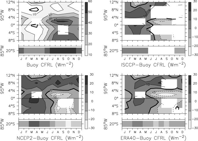
FIG. 7. Same as in Fig. 6 but for surface longwave cloud forcing.
The results shown here are consistent with the discrepancies in total cloud cover shown in Fig. 9: Too much cloud cover results in too much cloud forcing in the ITCZ region and during the warm season south to 8°S (Figs. 6–7), while too thin cloud cover results in too little cloud forcing under the stratus cloud deck at 20°S and during the cold season north to the equator. These comparisons show that solar cloud forcing dominates the total cloud forcing and that its error dominates the bias. Consequently, the net result of the solar and longwave cloud forcing discrepancies is that these NWP products have too little radiative warming in the ITCZ and southward to 8°S during the warm season and too much radiative warming in the stratus deck region at 20°S and northward to the equator during the cold season (Fig. 8).
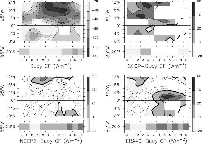
FIG. 8. Same as in Fig. 6 but for total surface cloud forcing, defined as the sum of solar and longwave cloud forcing.
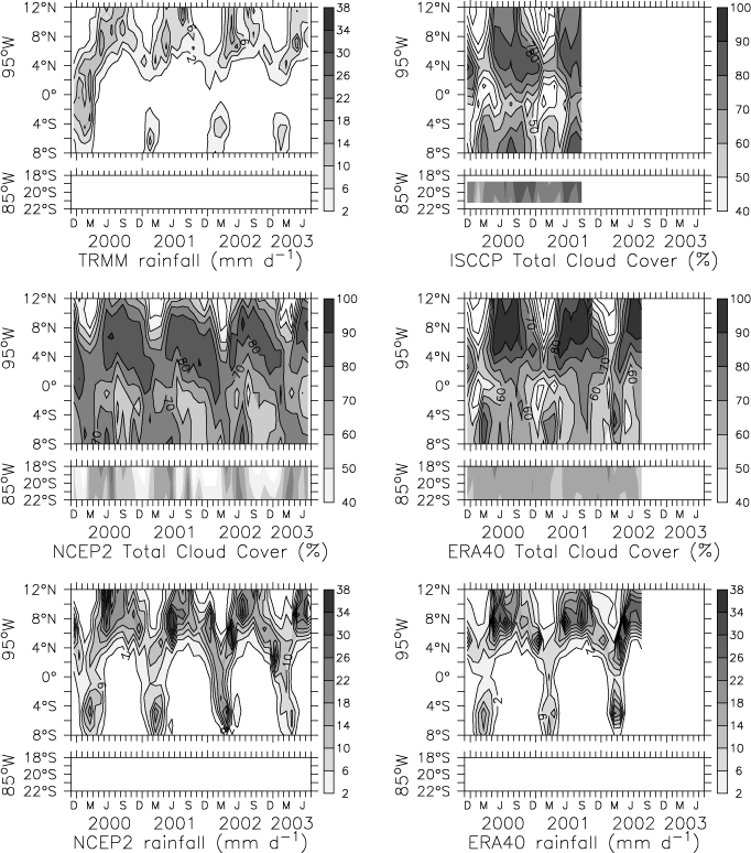
FIG. 9. Monthly averaged precipitation and total cloud cover (TCC) along 95°W from 8°S to 12°N and at 20°S, 85°W: (top left) TRMM rain rate, (top right) ISCCP TCC, (middle left) NCEP2 TCC, (middle right) ERA-40 TCC, (bottom left) NCEP2 rain rate, and (bottom right) ERA-40 rain rate. Precipitation units of mm day![]() ; TCC is unitless and scales from 0 (no clouds) to 1 (full cloud coverage).
; TCC is unitless and scales from 0 (no clouds) to 1 (full cloud coverage).
c. Radiative properties of precipitating and nonprecipitating clouds
Because emission of longwave radiation by clouds is strongly dependent on temperature, different cloud types have a different ratio of solar to longwave cloud forcing. The subcloud water vapor concentrations also affect IR flux more than solar flux; thus, conditions with similar cloud base heights may have different longwave (IR) forcing. More humid boundary layers will tend to have lower IR cloud forcing (Stephens and Webster 1981). Thus, to diagnose the radiative properties across the stratus deck/cold tongue/ITCZ complex, the ratio of the longwave to solar cloud forcing (CFR![]() /CFR
/CFR![]() ) is computed for six different regions. These regions are as follows: stratus deck (~20°S, 85°W), southern (9°S–3.5°S), cold tongue (3.5°S–1°N), frontal (1°N–6.5°N), ITCZ (6.5°N–11°N), and northeast Pacific warm pool (11°N–13°N).
) is computed for six different regions. These regions are as follows: stratus deck (~20°S, 85°W), southern (9°S–3.5°S), cold tongue (3.5°S–1°N), frontal (1°N–6.5°N), ITCZ (6.5°N–11°N), and northeast Pacific warm pool (11°N–13°N).
In the previous section, fields were presented as contoured plots and pixel time series. Because data gaps were not filled through interpolation, sites with gaps in adjacent sites could not be contoured. In contrast, in scatterplots, all data can be shown. In Figs. 10 and 11, scatterplots of CFR![]() versus CFR
versus CFR![]() for each region are shown for months when the region had significant rainfall and months when the region had no significant monthly averaged rain as determined by the TRMM rainfall product for the buoy and ISCCP satellite fields and by the corresponding precipitation field for the NWP fields. For the TRMM rainfall, significance was determined based upon the error level provided by the TRMM product. Along 95°W from 8°S to 12°N, the mean error was 1.68 mm day
for each region are shown for months when the region had significant rainfall and months when the region had no significant monthly averaged rain as determined by the TRMM rainfall product for the buoy and ISCCP satellite fields and by the corresponding precipitation field for the NWP fields. For the TRMM rainfall, significance was determined based upon the error level provided by the TRMM product. Along 95°W from 8°S to 12°N, the mean error was 1.68 mm day![]() ; at 20°S, 85°W, the mean error was 0.48 mm day
; at 20°S, 85°W, the mean error was 0.48 mm day![]() . These values were used as significance levels for the NWP precipitation. None of the rain products had significant rainfall at 20°S, 85°W.
. These values were used as significance levels for the NWP precipitation. None of the rain products had significant rainfall at 20°S, 85°W.
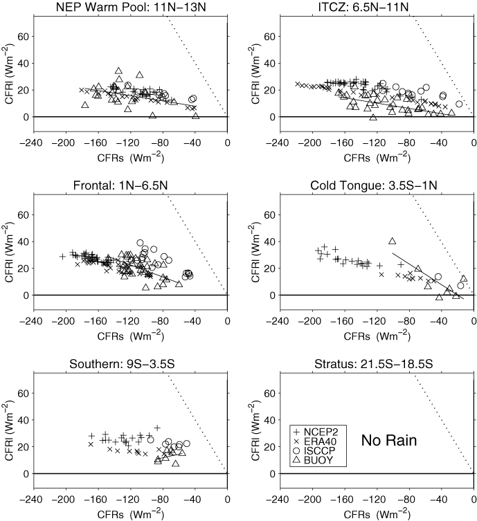
FIG. 10. Scatterplots of monthly averaged longwave cloud forcing vs solar cloud forcing for precipitating clouds in six latitudinal bands defined as northeast Pacific warm pool (11°–13°N, 95°W), ITCZ (6.5°–11°N, 95°W), frontal (1°–6.5°N, 95°W), cold tongue (3.5°S–1°N, 95°W), southern (9°–3.5°S, 95°W), and stratus (21.5°–18.5°S, 85°W). As shown in the legend in the lower left, buoy values are indicated by ![]() , NCEP2 by +, ERA40 by ×, and ISCCP by o. The negative 1–1 line is indicated by a dotted line. A thick black line extending over the range of the buoy solar cloud forcing shows the least squares straightline fit of the buoy cloud forcing values. Significant rainfall was determined by TRMM rainfall within each latitudinal bin.
, NCEP2 by +, ERA40 by ×, and ISCCP by o. The negative 1–1 line is indicated by a dotted line. A thick black line extending over the range of the buoy solar cloud forcing shows the least squares straightline fit of the buoy cloud forcing values. Significant rainfall was determined by TRMM rainfall within each latitudinal bin.
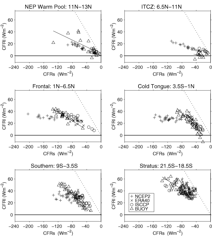
FIG. 11. Same as in Fig. 10 but for months with no significant rainfall.
As shown in Figs. 10 and 11, the slope of longwave to solar cloud forcing is closest to -1 in the cold tongue, southern, and stratus deck regions under nonprecipitating conditions. Note that a value of -1 implies that IR and solar cloud forcing cancel and there is no net effect of clouds on the surface energy budget. This, however, was never observed. At the surface, longwave cloud forcing is always less than the solar cloud forcing for all regions in this study. The flattest slopes (indicating clouds that have a marginal effect on downwelling longwave radiation but are relatively opaque to solar radiation) were in the ITCZ region under significant rainfall. Both the warm pool and ITCZ regions have extremely large ranges in monthly averaged solar cloud forcing (~157–165 W m![]() ). In contrast, the range of longwave cloud forcing in the ITCZ was about half that found elsewhere. The most dramatic discrepancy is in the cold tongue region, where NCEP2 clouds have ITCZ-type radiative properties rather than Southern Hemisphere stratus deck (closer to -1) properties. To provide a benchmark for models, the slope and intercept of the least squares straight line fit to the buoy CFR
). In contrast, the range of longwave cloud forcing in the ITCZ was about half that found elsewhere. The most dramatic discrepancy is in the cold tongue region, where NCEP2 clouds have ITCZ-type radiative properties rather than Southern Hemisphere stratus deck (closer to -1) properties. To provide a benchmark for models, the slope and intercept of the least squares straight line fit to the buoy CFR![]() to CFR
to CFR![]() scatter is shown in Tables 1 and 2 for precipitating and nonprecipitating conditions, and for all cloud types in each region in Fig. 12 and Table 3. Overall, the cold tongue region has the most well defined CFR
scatter is shown in Tables 1 and 2 for precipitating and nonprecipitating conditions, and for all cloud types in each region in Fig. 12 and Table 3. Overall, the cold tongue region has the most well defined CFR![]() to CFR
to CFR![]() seasonal cycle relation, while the warm pool region has the most scatter (Table 3).
seasonal cycle relation, while the warm pool region has the most scatter (Table 3).
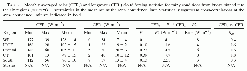
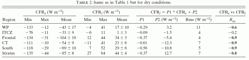
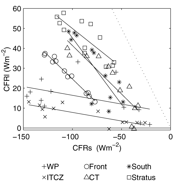
FIG. 12. Scatterplots of longwave cloud forcing mean annual cycle vs solar cloud forcing mean annual cycle from buoy data in six latitudinal bands listed in Fig. 10 for all cloud types.
d. Clear-sky background radiation
The relative effectiveness of clouds to emit longwave radiation and transmit solar radiation depends not only on the cloud properties, but also upon the background emission and transmission properties of the lower troposphere. For example, longwave cloud forcing tends to be weaker in a moist region than in a dry region, all else being the same. Because cloud forcing depends upon a modeled estimate of the expected radiation under clear skies, errors in the modeled clear-sky radiation could bias the solar and longwave cloud forcing estimates. As shown in Figs. 13 and 14, in addition to a mean bias, deviations in the solar clear-sky radiation at all sites and IR clear-sky radiation south of 2°N have a seasonal cycle with a 10 W m![]() amplitude. Mean deviations in solar clear-sky radiation were largest at 20°S, while mean deviations for longwave clear-sky radiation were largest at and north of the ITCZ. It is uncertain if the solar and longwave clear-sky radiation are modeled better in the buoy or nonbuoy fields. The important point, however, is that clear-sky discrepancies are small when compared to the differences of 20–100 W m
amplitude. Mean deviations in solar clear-sky radiation were largest at 20°S, while mean deviations for longwave clear-sky radiation were largest at and north of the ITCZ. It is uncertain if the solar and longwave clear-sky radiation are modeled better in the buoy or nonbuoy fields. The important point, however, is that clear-sky discrepancies are small when compared to the differences of 20–100 W m![]() between the buoy and NWP solar cloud forcing. Hence, outside of the stratus deck region, the principal sources of the error in the NWP surface cloud forcing and incident radiation appear to be specification of cloud type and coverage and location of the ITCZ.
between the buoy and NWP solar cloud forcing. Hence, outside of the stratus deck region, the principal sources of the error in the NWP surface cloud forcing and incident radiation appear to be specification of cloud type and coverage and location of the ITCZ.
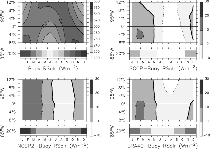
FIG. 13. Same as in Fig. 6 but for clear-sky solar radiation at the surface.
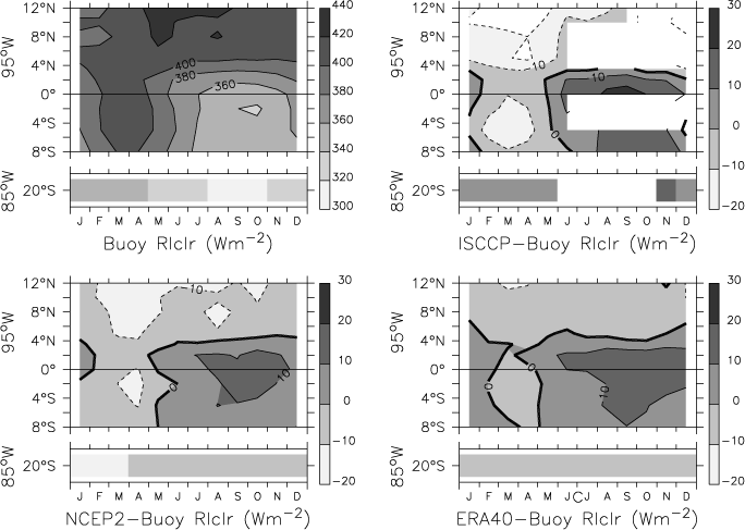
FIG. 14. Same as in Fig. 6 but for clear-sky longwave radiation at the surface.
Return to previous section or go to next section