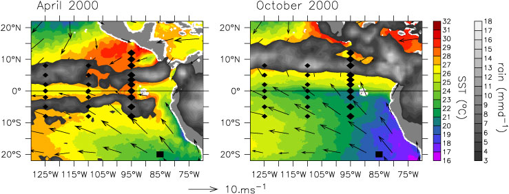
FIG. 1. EPIC mooring array shown in relation to (left) April 2000 and (right) October 2000 TRMM Microwave Imager (TMI) sea surface temperature, TRMM rain rate, and Quick Scatterometer (QuikSCAT) surface winds. Diamonds indicate TAO buoys. Large diamonds indicate EPIC-enhanced 95°W TAO buoys. The Woods Hole IMET buoy is indicated by a large square.
Clouds have both a cooling and warming effect on the earth's surface. Because clouds reflect solar radiation back to space, shortwave (solar) cloud forcing acts as a cooling effect, a reduction in the solar radiation that warms the earth's surface. But clouds also have a warming effect through their emission of longwave infrared (terrestrial) radiation, thereby increasing downwelling longwave radiation at the earth's surface. The relative amount of surface warming and cooling by clouds (i.e., relative amount of longwave and shortwave surface cloud forcing) depends upon many factors including cloud-base height, cloud thickness, background moisture, and aerosol distributions. It is thus not surprising that models have difficulties obtaining realistic radiative properties (Cess et al. 1989, 1990, 1996; Weare 1997; Siebesma et al. 2004.). Indeed, both the Intergovernmental Panel on Climate Change (IPCC) second and third assessment reports state that "the single largest uncertainty in determining the climate sensitivity to either natural or anthropogenic changes are clouds and their effects on radiation and their role in the hydrological cycle" (Kattenberg et al. 1996, p. 345; Moore et al. 2001, p. 776). Both assessments call for comparisons of model simulations with observations.
In this analysis we use surface shortwave and longwave cloud forcing measurements from 11 moorings in the far eastern tropical Pacific to provide benchmarks for satellite, numerical weather prediction models, and atmospheric climate models. The eastern tropical Pacific near the Pan-American landmass is characterized by a complicated meridional cloud structure, with a persistent stratus deck shading the cool Southern Hemisphere waters and deep convection in the intertropical convergence zone (ITCZ) over the warm surface waters north of the equator. Along the equator, upwelling causes a "cold tongue" of water to extend westward from the coast, with a sharp sea surface temperature (SST) front on its northern flank. Because the planetary boundary layer (PBL) tends to be capped by a strong temperature inversion over the cold tongue and to be destabilized over the warm water, the SST front tends to induce a front in the cloud structure (Hashizume et al. 2002; Chelton et al. 2001; Xie et al. 1998; deSzoeke et al. 2005).
The stratus deck/cold tongue/ITCZ complex has a strong seasonal cycle, as illustrated by Fig. 1: When the trade winds weaken during January–March, the cold tongue recedes and a double ITCZ straddling the equator often forms (Lietzke et al. 2001; Zhang 2001). These changes have substantial impacts on fractional cloud cover and type. The eastern tropical Pacific also experiences significant interannual variability, especially in association with El Niño-Southern Oscillation (ENSO). During El Niño warm events, deep convection can occur near the equator and the meridional asymmetry of the cloud structure is weakened (Wallace et al. 1998).
General circulation models (GCMs), although steadily improving, are not able to reproduce much of this structure and variability. Common problems include a warm SST bias in the stratocumulus region, a cool SST bias in the equatorial cold tongue, and a persistent double ITCZ (Mechoso et al. 1995; Lau et al. 1996; Latif et al. 2001; Davey et al. 2002). Poor cloud parameterizations that cause improper cloud formation and/ or clouds with incorrect radiative properties are often suspected of causing many of these biases. In particular, Philander et al. (1996) found that the eastern Pacific ITCZs were sensitive to the parameterization of low-level stratus clouds in the coupled GCM. In a concerted effort to improve these GCMs, a 5-yr experiment, the Eastern Pacific Investigation of Climate Studies (EPIC), was initiated in 1999. As part of enhanced monitoring for EPIC, 11 surface moorings in the far eastern tropical Pacific were equipped with a suite of instrumentation, including shortwave and longwave radiometers. Although some of the moorings suffered losses from fishing-related vandalism, nearly four years of solar and longwave cloud forcing measurements were obtained.
In this paper we use data from the EPIC mooring array to analyze the structure and variability of surface cloud forcing in the eastern tropical Pacific. These in situ radiation fields are compared to the more traditional benchmark radiation dataset from the International Satellite Cloud Climatology Project (ISCCP) and to radiation fields from commonly used numerical weather prediction (NWP) reanalyses, namely the 40-yr European Centre for Medium-Range Weather Forecasting (ECMWF) Re-Analysis (ERA-40) and the National Centers for Environmental Prediction Reanalysis 2 (NCEP2). Discrepancies in the cloud forcing fields from benchmark datasets are analyzed using the corresponding total cloud cover and precipitation fields to identify the prevalence of precipitating and nonprecipitating clouds and the radiative properties of precipitating and nonprecipitating clouds
Return to Abstract or go to the next section