U.S. Dept. of Commerce / NOAA / OAR / PMEL / Publications
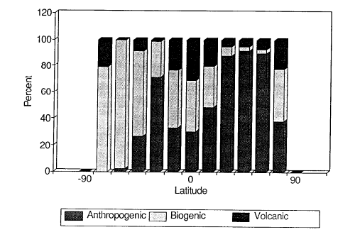
The biogenic sulfur emissions calculated above are summarized by latitude in Table 6 and Figure 3. By comparing these values with estimates of anthropogenic sulfur emissions, we can begin to assess the magnitude of the anthropogenic perturbation to the natural atmospheric sulfur cycle. Hameed and Dignon (1990) estimate anthropogenic sulfur emissions for fossil fuel burning at 2.0 Tmol S for the year 1986. This is an update of their earlier 1980 estimates (Hameed and Dignon, 1988; Dignon and Hameed, 1989). Varhelyi (1985) has made sulfur emission estimates for the industrial sector of 2.5 Tmol S/a with 78% emitted in the northern hemisphere and 22% in the southern hemisphere. The estimates of Varhelyi can be scaled latitudinally with the fossil fuel source of Hameed and Dignon (1990) to create a global mapping of anthropogenic sulfur emissions (Dignon, 1990). In Table 6 the global anthropogenic source of 2.5 Tmol S/a is presented by latitude.
Fig. 3. Global emissions of anthropogenic (includes biomass burning), biogenic (marine and terrestrial), and volcanic sulfur.
| Region | Oceanic | Terrest- | Vol- | biomass | Anthro- | Biogenic/ | Natural/ | |
|---|---|---|---|---|---|---|---|---|
| rial | canic | burning | pogenic | totalą | total˛ | |||
| 80°–65°N | 4 | 0.02 | 2 | 0.4 | 3 | 40% | 62% | |
| 65°–50°N | 19 | 0.40 | 43 | 2.3 | 534 | 3 | 10 | |
| 50°–35°N | 31 | 0.95 | 53 | 3.3 | 942 | 3 | 8 | |
| 35°–20°N | 46 | 2.05 | 37 | 7.1 | 598 | 7 | 12 | |
| 20°–5°N | 79 | 2.52 | 54 | 20.7 | 106 | 31 | 52 | |
| 5°N–0° | 26 | 1.14 | 17 | 4.2 | 18 | 41 | 67 | |
| 0°–5°S | 25 | 1.10 | 27 | 3.6 | 16 | 36 | 73 | |
| 5°–20°S | 82 | 2.11 | 45 | 17.3 | 47 | 44 | 67 | |
| 20°–35°S | 60 | 0.86 | 2 | 9.2 | 153 | 27 | 28 | |
| 35°–50°S | 60 | 0.08 | 8 | 0.7 | 24 | 65 | 73 | |
| 50°–65°S | 50 | 0.00 | 0 | 0.2 | 1 | 98 | 98 | |
| 65°–80°S | 4 | 0.00 | 1 | 0.0 | 0 | 79 | 100 | |
| N. Hemisphere | 200 | 7.1 | 210 | 38 | 2200 | 8 | 16 | |
| S. Hemisphere | 280 | 4.1 | 83 | 31 | 240 | 45 | 58 | |
| Global | 480 | 11. | 290 | 69 | 2400 | 15 | 24 | |
| ą (Marine + Terrestrial) * 100 / (Marine + Terrestrial + Volcanic + Anthropogenic + Biomass burning). | ||||||||
| ˛ (Marine + Terrestrial + Volcanic) * 100 / (Marine + Terrestrial
+ Volcanic + Anthropogenic + Biomass burning). |
||||||||
The biomass burning source is presented by latitude in Table 6 and is based on the 1 × 1 degree vegetation map of Matthews (1982) and the biomass burning inventories of Dignon and Penner (1990) and Logan et al. (1990). Volcanic sources have been apportioned by latitude based on the eruption data between 1975 and 1985 (McClelland et al., 1989). During this period there were 149 erupting volcanoes and for the purposes of this latitudinal comparison, we assume that the number of volcanoes which erupted in each region between 1975-1985 is directly proportional to the sulfur emitted by active volcanoes in these regions.
It is clear from these data that the region between 35° and 50°N is seriously impacted by anthropogenic emissions with only 8% of the total sulfur emissions coming from natural sources. Natural sulfur emissions are still a significant fraction (30-100%) of the total sulfur emissions in the tropical latitudes of the northern hemisphere (0-20°N) and in all latitude belts of the southern hemisphere. Although there are certainly smaller regions in the southern hemisphere where anthropogenic sulfur emissions dominate over natural emissions, 90% of the anthropogenic sulfur emissions occur in the northern hemisphere while natural sulfur emissions are more evenly divided between the two hemispheres.
Terrestrial biogenic sulfur emissions may be important in localized regions (Andreae and Andreae, 1988), but are insignificant on the latitudinal scales compiled here. Volcanic and oceanic emissions, however, are a significant fraction of the total sulfur flux to the atmosphere and make up 58% of the total sulfur emissions in the southern hemisphere.
These data provide both seasonal and latitudinal distributions of the major sources of sulfur to the atmosphere. Although the latitudinal comparisons of the various sources provide an insight into the magnitude of the anthropogenic perturbations to the natural cycle, it is difficult to assess the climatic impacts of these perturbations with the data presented here since the lifetimes of the various sulfur species are too short to mix the sulfur species throughout the latitudinal bands. However, these data do provide input for global circulation-climate models and studies of the climatic effect of sulfur emissions (Charlson et al., 1987; Charlson et al., 1990; Erickson et al., 1990; Penner, 1990). These modelling efforts are certainly limited by available data and critically need further field studies of both sulfur emissions and the processes that drive the atmospheric biogeochemical sulfur cycle.
Acknowledgments. We thank G. Allwine and M. Maring for the terrestrial sulfur calculations, H. Berresheim for comments on volcanic emissions, F. Fehsenfeld for his encouragement to write this manuscript, and the NOAA National Acid Precipitation Assessment Program (NAPAP) for support. This is contribution 1229 from the Pacific Marine Environmental Laboratory.
Go back to previous section or forward to next section
 mol/a
mol/a