Sunke Schmidtko, Gregory C. Johnson, John M. Lyman
This site has a European analogue.
About MIMOCMIMOC (Monthly Isopycnal / Mixed-layer Ocean Climatology) is a trio of global monthly ocean property maps from 80°S to 90°N at 0.5° lateral resolution, all available for download. Products include mixed layer and select interior ocean isopycnal maps. These maps are combined into a third set of maps on 81 standard pressure levels from the surface (0 dbar) to 1950 dbar (approximately 1925 m). The maps are based mostly on Argo CTD data, supplemented by shipboard and Ice-Tethered Profiler CTD data. The maps mostly reflect the modern ocean state, although they relax back to historic data from as early as the 1970s when no recent data are available for a region or season. The supported data format is netCDF and additional geotiff images for the mixed-layer (for use in e.g. ESRI-ArcGIS). Please contact us if you have problems reading these data files and would like to request a different format. We anticipate updating MIMOC to include pressures exceeding 1950 dbar, improving error estimates, and so on, in the future. Attention: The current website is preliminary - and will be improved over time. The current version of MIMOC is 2.2. Please send us an email if you want to be notified when MIMOC is updated. Download the data files below, or have a look at the gallery. |
Seasonal tropical variability in 65dbar: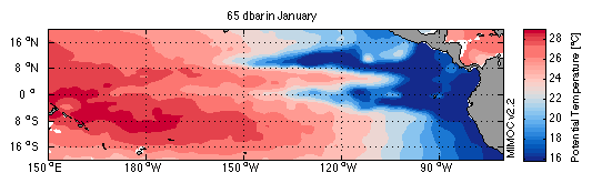 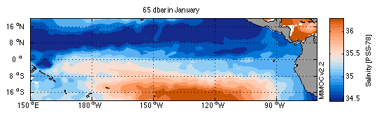 This way to the MIMOC gallery |
Description:
MIMOC is described and compared with some existing ocean climatologies in the manuscript just below. Please click on the title for a link to the latest version of this manuscript:
Schmidtko, S., G. C. Johnson and J. M. Lyman, 2013. MIMOC: A Global Monthly Isopycnal Upper-Ocean Climatology with Mixed Layers. Journal of Geophysical Research, 118, in press, doi: 10.1002/jgrc.20122.
Disclaimer:
We have constructed MIMOC carefully and examined the maps for errors, but please let us know if you find artifacts. Feel free to use MIMOC for any non commercial purposes, but do so at your own risk, we cannot take any liability on the use of MIMOC.
Acknowledging use:
Please cite Schmidtko, Johnson, and Lyman (2013) when using MIMOC. We would like to maintain a bibliography of publications using MIMOC, so please e-mail us details of your published analyses using MIMOC. We would love to hear about all uses of MIMOC, or even if you find MIMOC was not useful, so please keep in touch.
Downloading MIMOC:
Pressure-gridded global monthly x 0.5° x 0.5° netCDF files including pressure, longitude, and latitude vectors as well as data matrices for salinity and temperature (always absolute salinity and conservative temperature, and sometimes also practical salinity and potential temperature) are available below. Similarly, files for mixed layer maps with data matrices for salinity, temperature, and maximum mixed layer pressure are available. Files for maps on potential isopycnals with data matrices for pressure, temperature, and are also available. Each zipped file is on the order of 75MB for the pressure grid, 77MB for the isopycnal maps, and 3MB for the mixed layer maps. Weighted mean maps are smoother than objective maps, and may be useful for model initialization or calculation requiring smoother fields. While maps have already been screened for data quality, the summed weighted number of observations for each grid point is provided for further assessment, along with the mapped year of the data. Error fields and mapped residuals are anticipated in future releases.
Download MIMOC files:
Variables in files
PT = Potential Temperature (IPTS-90)S = Practical Salinity (PSS-78)
CT = Conservative Temperature (TEOS-10)
SA = Absolute Salinity (TEOS-10)
P = Pressure
MLP = Mixed layer pressure (in dbar)
Yr = mapped year of grid point
W = sum of raw data weights used for grid point
File types:
ML = Mixed layer filez-grid = file pressure gridded onto 81 standard pressure levels
sig-grid = file gridded on 75 sigma0 surfaces
vX.Y = version number of MIMOC
01-12 = climatological month
Files with a 'wm' after the version number contain the smoother weighted mean fields. All other files contain the optimal interpolated fields.
optimal interpolated 0-1950dbar monthly MIMOC netCDF files:
optimal interpolated mixed-layer monthly MIMOC:
| Potential Temperature & Salinity & Mixed Layer Depth | Conservative Temperature & Absolute Salinity & Mixed Layer Depth | |
| January-December | MIMOC v2.2 ML PT S MLP 01-12 | MIMOC v2.2 ML CT SA MLP 01-12 |
weighted mean 0-1950dbar monthly MIMOC files
(Please keep in mind that historic data are not downweighted in the weighted mean fields, thus these maps are less likely to represent the modern state of the ocean than the optimal interpolated maps.)
weighted mean mixed-layer monthly MIMOC:
| Potential Temperature & Salinity & Mixed Layer Depth | Conservative Temperature & Absolute Salinity & Mixed Layer Depth | |
| January-December | MIMOC v2.2wm ML PT S MLP 01-12 | MIMOC v2.2wm ML CT SA MLP 01-12 |
geotiff images of Mixed-layer monthly MIMOC:
(Please keep in mind that historic data are not downweighted in the weighted mean fields, thus these maps are less likely to represent the modern state of the ocean than the optimal interpolated maps.)
| Weighted mean Fields | Objective Analyzed fields | |
| January-December | MIMOC v2.2wm ML CT SA PT S MLP 01-12 | MIMOC v2.2 ML CT SA PT S MLP 01-12 |
We would be happy to list any publications using this climatology. If your research results in a publication please send us the citation.
Publications using above climatology:
Johnson, G. C., S. Schmidtko, and J. M. Lyman, 2012: Relative contributions of temperature and salinity to seasonal mixed layer density changes and late-winter horizontal density gradients. Journal of Geophysical Research, vol. 117, C04015, 13 PP. doi:10.1029/2011JC007651