[Thread Prev][Thread Next][Index]

Re: [ferret_users] Sverdrup Streamfunction - indefinite integral withirregular boarders


The Sverdrup relation (Beta*V=Curl[tau]) only describes the interior circulation of an ocean, integrated west from the eastern boundary to just inside the western boundary. It explicitly does not encompass the western boundary currents, because as a westward integral it does not include the physics of the boundary layer, which must involve some other dynamics (in various models lateral friction, nonlinearity, eastward-propagating short Rossby waves). The calculation you are attempting does not make sense physically.

This problem was solved by Stuart Godfrey, in what I think is one of the most elegant results of dynamical oceanography, the "Island Rule" (Godfrey, J.S., 1989: A Sverdrup model of the depth-integrated flow for the world ocean allowing for island circulations. Geophys.Astrophys.Fluid Dyn., 45, 89-112; also see subsequent papers by Roxana Wajsowicz).

Physically, the requirement is that the streamfunction is constant along a land boundary. That means transport across a closed ocean basin (say the northern Indian Ocean) must be zero. The western boundary current must exactly balance the interior transport from the Sverdrup relation. If Bering Strait is considered closed, and a starting point (just to pick a constant of integration) is chosen at Cape Horn, then the streamfunction is zero along the west coast of the Americas, continuing entirely around East and South Asia (i.e. through the Indonesian Throughflow), around Africa and Europe, around the Arctic Ocean if it is included, and down the east coast of the Americas back to Cape Horn. Notably omitted from this requirement are Australia, New Zealand and Madagascar.

Some parts of this CAN be found in Ferret: start from zero along the west coast of the Americas north of the equator (so as not to involve Australia/New Guinea), integrate the curl westward to Asia. Or start from Africa-Europe, integrate to the Americas. The Sverdrup relation gives the interior transport, and the assumption that the streamfunction is zero along those western boundaries completes the solution. Note that this does not say anything about the details of the western boundary layer, just its total transport, which in steady state must exactly balance the interior (Sverdrup) transport.

The above does not give the solution in the South Pacific or the Indian Ocean south of the Throughflow. That is the problem Godfrey solved. Elegantly, and with no information but the wind. It is a little too involved to write in an e-mail, but I urge you to read his paper (perhaps more clearly explained in Wajsowicz (1993 JPO, 1470-1484)). Godfrey realized that the vertically-integrated pressure difference between the south and north tips of an island can be found two ways from the momentum eqns: One, integrating the stress along a path from the south point (e.g. Tasmania) east to South America, north along the coast to the equator, and west along the equator to New Guinea; Two, integrating the stress along the west coast of Australia from Tasmania to New Guinea. These two integrals must give the same value, and the constant that resolves this is the net meridional transport through the South Pacific (or equivalently through the Indonesian Throughflow). That gives the streamfunction value at Australia, which is not zero. Spectacularly, that gives the transport of the ITF, which conforms well to the observed value. Knowing the value of the streamfunction along the coast of Australia, one can then integrate west across the Indian Ocean, do the same procedure for Madagascar, and have a complete Sverdrup streamfunction for the world ocean north of Drake Passage. (Refinements are to include New Zealand and some of the larger islands of the Pacific, which provide important details).

See the attached figure for an example (or many details at http:// www.pmel.noaa.gov/~kessler/sverdrup/islandrule/islandrule.html). The values in the subtitle give the streamfunction values at the various islands.

As far as I can tell this calculation must be done in fortran, because it requires working north along coasts to specified points, then west, then restarting again at the south points of islands. It is something of a pain! The algorithm is described in Godfrey (1989).

This method does not deal with the Southern Ocean, for which the Sverdrup streamfunction is not defined because there is no eastern boundary; some other dynamics must be involved, and this remains a subject of debate (see papers by Steve Rintoul, among others).

A further refinement is to include non-linear terms in a Sverdrup- like solution, which makes important improvements in the equatorial current systems (see Kessler et al, 2003, available at http:// www.pmel.noaa.gov/~kessler/kjm01-abstract.html).

Billy K

GIF image


On Apr 3, 2006, at 2:45 AM, Dr. Theodor Yemenis wrote:

Hi Ansley,

thanks for your answer but something doesnt work properly.

my curl_tau is missing over land, so I don't need the land-mask.

if I define PSI like:

LET PSI = IF curl_tau[x=150E:0] THEN (1/(beta*rho_ocean))*( (-1) *curl_tau[x=150E:0@iin] + curl_tau[x=150E:0@din] )/1E06

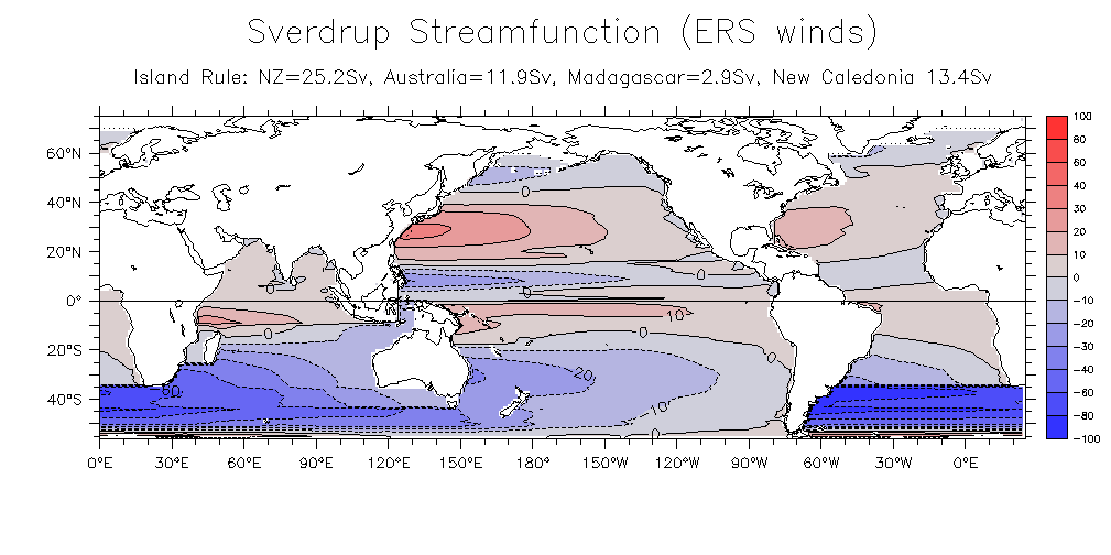
the result looks like in the attached image.

The calculation breaks at the boundaries and behind missing values (islands).
I think @iin doesnt like missing values but I dont know how to filter them out
so that the integration would be executed only over non-missing values.


best regards
Theodor

Ansley Manke wrote:


Hi Theodor,
I admit to looking at this just briefly, so I may be missing something. Is your variable curl_tau missing over land? In that case, in your definition of psi you should leave off the ELSE 0. The result will be missing wherever the expresssion curl_tau [x=160E:0@iin] is false. On this kind of definition there is an implied "ELSE missing"

Otherwise you need to apply a mask to the data as outlined in this FAQ about doing integration or averaging over irregular fields by applying a mask;
http://www.ferret.noaa.gov/Ferret/FAQ/analysis/avg_integ_irreg.html

For your case the mask would be a field which is 1 over water and missing over land.You could make such a variable from one of the topography data sets, choosing one which has a resolution similar to the grid your data is on

yes? use etopo20 yes? let mask = IF rose[d=etopo20,gxy=curl_tau [d=1]] LT 0 then 1
yes? shade mask ! Look at the plot to check the definition

Dr. Theodor Yemenis wrote:


I am trying to calculate and plot with FERRET the Sverdrup Streamfunction from the wind stress curl curl_tau

acording to the formel:

Psi = 1/beta Int_xlim(y) ^x curl(tau)dx, xlim (y) is the longitude of the boundary at each latitude.

I use the following definition (for the pacific ocean):

LET PSI = IF curl_tau[x=160E:0@iin] THEN (1/(beta*rho_ocean))* ( (-1)*curl_tau[x=160E:0@iin] + curl_tau[x=160E:0@din] )/1E06 ELSE 0

fill PSI ; go land

the result is as in the attached GIF-image, but it is not sutisfing. I have the following problem:

- the islands(Hawaii, New Zeland, ...) and the Continent (Australia) disdurb the calculation (no streamfunction behind the land-boarders).
The problem is computing an indefinite integral in an area with irregular boundaries.
How can I solve this? Can someone help?

best regards
Theodor


-------------------------------------------------------------------- ----


--
--------------------------------------
Dr. Theodoros Yemenis
Center for Marine and Atmospheric Research
University of Hamburg
Institute of Oceanography
Bundesstrasse 53
D-20146 Hamburg
Germany
---------------------------------------

phone:   +49 40 42838 6104
 fax:   +49 40 42838 7063
        +49 40 36 801 801
email:   yemenis@ifm.zmaw.de   ---------------------------------------


<Streamfunction.test.gif>


[Thread Prev][Thread Next][Index]

Dept of Commerce / NOAA / OAR / PMEL / TMAP

Contact Us | Privacy Policy | Disclaimer | Accessibility Statement